Bridge Statistics for Newburgh, New York (NY)
Condition, Traffic, Stress, Structural Evaluation, Project Costs
- National Bridge Inventory (NBI) Statistics
- 21Number of bridges
- 144ft / 43.8mTotal length
- $54,681,000Total costs
- 100,280Total average daily traffic
- 4,481Total average daily truck traffic
- National Bridge Inventory (NBI) Registered Bridges for Newburgh
- No street view available for this location
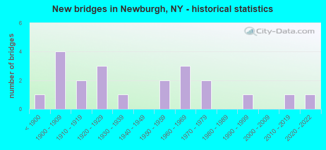
- New bridges - historical statistics
- 1Before 1900
- 41900-1909
- 21910-1919
- 31920-1929
- 11930-1939
- 21950-1959
- 31960-1969
- 21970-1979
- 11990-1999
- 12010-2019
- 12020-2022
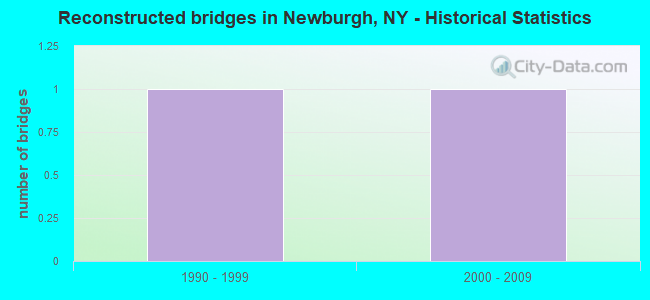
- Reconstructed bridges - Historical Statistics
- 11990-1999
- 12000-2009
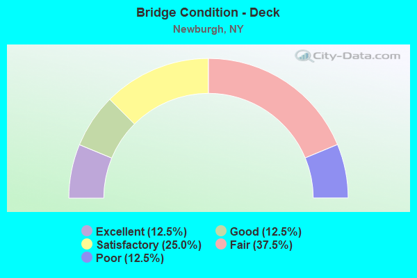
- Bridge Condition - Deck
- 12.5%Excellent
- 12.5%Good
- 25.0%Satisfactory
- 37.5%Fair
- 12.5%Poor
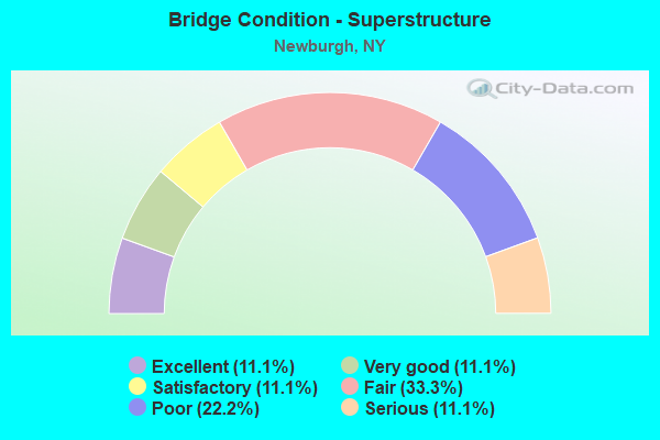
- Bridge Condition - Superstructure
- 11.1%Excellent
- 11.1%Very good
- 11.1%Satisfactory
- 33.3%Fair
- 22.2%Poor
- 11.1%Serious
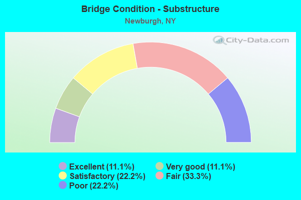
- Bridge Condition - Substructure
- 11.1%Excellent
- 11.1%Very good
- 22.2%Satisfactory
- 33.3%Fair
- 22.2%Poor
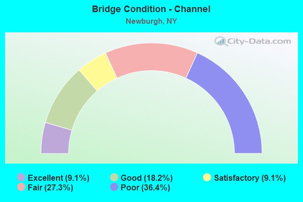
- Bridge Condition - Channel
- 9.1%Excellent
- 18.2%Good
- 9.1%Satisfactory
- 27.3%Fair
- 36.4%Poor
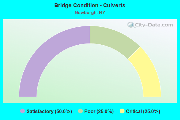
- Bridge Condition - Culverts
- 50.0%Satisfactory
- 25.0%Poor
- 25.0%Critical
Find on map >> Show street view
Structure Number: 100728, Location: JCT US 9W & QUASSAICK CRK (Lat: 41.491272, Lng: -74.021867), Route carried "on" structure: US 9W, Year Built: 1952, Year Reconstructed: 2013, Status: Posted for load-capacity, Structure Length: 17.50m (57.41ft), Average Daily Traffic: 9,504 (year 2020), Truck Traffic: 7%, Average Future Daily Traffic: 9,548 (year 2040), Design Load: H 20, Features Intersected: CSX TRANS/NWBG IT, QUASS
Minimum Vertical Clearance: 30+ m (98+ ft), Kilometerpoint: 25.808, Lanes on structure: 4, Base Highway Network: Yes, Owner: State Highway Agency, Approaching Roadway Width: 13.4m (44.0ft), Skew: 3 degrees, Material/Design: Steel, Design/Construction: Stringer/Multi-beam, Number Of Spans In Main Unit: 10, Length of Maximum Span: 21.9m (71.9ft), Curb or Sidewalk Widths: Left: 1.5m (4.9ft), Right: 1.5m (4.9ft), Curb-To-Curb Width: 13.4m (44.0ft), Out-to-Out Width: 17.1m (56.1ft)
Condition: Deck: Fair, Superstructure: Fair, Substructure: Satisfactory, Channel: Fair, Operating Rating: 34.5 metric tons, Method Used To Determine Operating Rating: Load Factor (LF), Inventory Rating: 29.0 metric tons, Method Used To Determine Inventory Rating: Load Factor (LF), Structural Evaluation: Somewhat better than minimum adequacy, Deck Geometry: High priority of replacement, Underclear: Meets minimum limits, Waterway Adequacy: Meets minimum limits, Approach Roadway Alignment: Meets minimum limits, Length Of Structure Improvement: 17.49m (57.38ft), Designated Inspection Frequency: Every 24 months, Inspection Date: September 2021, Bridge Improvement Cost: $11,611,000, Roadway Improvement Cost: $6,800,000, Total Project Cost: $18,411,000 ( Estimate for 2021), Deck Structure Type: Concrete Cast-file-Place, Wearing Surface/Protective System: Wearing Surface: Bituminous, Membrane: Other
Find on map >> Show street view
Structure Number: 101453, Location: 1.5 MI E JCT RTS 17K+I87 (Lat: 41.502653, Lng: -74.047800), Route carried "on" structure: State highway 17K, Year Built: 1959, Year Reconstructed: 1995, Status: Open, Structure Length: 1.13m (3.71ft), Average Daily Traffic: 14,026 (year 2019), Truck Traffic: 5%, Average Future Daily Traffic: 14,091 (year 2040), Design Load: H 20, Features Intersected: QUASSAIC CREEK
Minimum Vertical Clearance: 30+ m (98+ ft), Kilometerpoint: 33.886, Lanes on structure: 4, Base Highway Network: Yes, Owner: State Highway Agency, Approaching Roadway Width: 11.3m (37.1ft), Skew: 1 degrees, Material/Design: Concrete continuous, Design/Construction: Culvert, Number Of Spans In Main Unit: 2, Length of Maximum Span: 5.2m (17.1ft), Curb or Sidewalk Widths: Left: 1.5m (4.9ft), Right: 1.5m (4.9ft)
Condition: Channel: Good, Culverts: Satisfactory, Operating Rating: 59.0 metric tons, Method Used To Determine Operating Rating: Load Factor (LF), Inventory Rating: 35.4 metric tons, Method Used To Determine Inventory Rating: Load Factor (LF), Structural Evaluation: Equal to present minimum criteria, Waterway Adequacy: Somewhat better than minimum adequacy, Approach Roadway Alignment: Equal to present desirable criteria, Length Of Structure Improvement: 1.12m (3.67ft), Designated Inspection Frequency: Every 24 months, Inspection Date: July 2021, Bridge Improvement Cost: $1,591,000, Roadway Improvement Cost: $931,000, Total Project Cost: $2,522,000 ( Estimate for 2021)
Find on map >> Show street view
Structure Number: 105018, Location: IN CITY OF NEWBURGH (Lat: 41.507342, Lng: -74.017728), Route carried "on" structure: City street , Year Built: 1962, Status: Open, Structure Length: 2.10m (6.89ft), Average Daily Traffic: 1,512 (year 2015), Truck Traffic: 2%, Average Future Daily Traffic: 1,870 (year 2040), Design Load: HS 20, Features Intersected: SOUTH STREET, Facility Carried by Structure: CARPENTER AVENUE
Minimum Vertical Clearance: 30+ m (98+ ft), Kilometerpoint: 0.708, Lanes on structure: 2, Lanes under structure: 2, Owner: State Highway Agency, Approaching Roadway Width: 9.1m (29.9ft), Material/Design: Concrete, Design/Construction: Frame, Number Of Spans In Main Unit: 1, Length of Maximum Span: 19.5m (64.0ft), Curb or Sidewalk Widths: Left: 1.5m (4.9ft), Right: 1.5m (4.9ft), Curb-To-Curb Width: 11.0m (36.1ft), Out-to-Out Width: 14.0m (45.9ft)
Condition: Deck: Satisfactory, Superstructure: Satisfactory, Substructure: Satisfactory, Operating Rating: 59.9 metric tons, Method Used To Determine Operating Rating: Load Factor (LF), Inventory Rating: 35.4 metric tons, Method Used To Determine Inventory Rating: Load Factor (LF), Structural Evaluation: Equal to present minimum criteria, Deck Geometry: Equal to present minimum criteria, Underclear: Somewhat better than minimum adequacy, Approach Roadway Alignment: Equal to present desirable criteria, Length Of Structure Improvement: 2.10m (6.89ft), Designated Inspection Frequency: Every 24 months, Inspection Date: June 2020, Bridge Improvement Cost: $2,420,000, Roadway Improvement Cost: $1,417,000, Total Project Cost: $3,838,000 ( Estimate for 2021), Wearing Surface/Protective System: Wearing Surface: Bituminous, Membrane: Other
Find on map >> Show street view
Structure Number: 10504, Location: 0. MIEJCTRTS9W+94 RIV RD (Lat: 41.488258, Lng: -74.009556), Route carried "on" structure: State highway 967, Year Built: 1929, Status: Open, Structure Length: 2.19m (7.19ft), Average Daily Traffic: 10,832 (year 2017), Truck Traffic: 3%, Average Future Daily Traffic: 13,158 (year 2040), Design Load: HS 20, Features Intersected: QUASSAIC CREEK
Minimum Vertical Clearance: 30+ m (98+ ft), Kilometerpoint: 2.462, Lanes on structure: 2, Base Highway Network: Yes, Owner: State Highway Agency, Approaching Roadway Width: 11.6m (38.1ft), Skew: 20 degrees, Material/Design: Concrete, Design/Construction: Tee Beam, Number Of Spans In Main Unit: 2, Length of Maximum Span: 10.7m (35.1ft), Curb or Sidewalk Widths: Left: 0.0m, Right: 1.4m (4.6ft), Curb-To-Curb Width: 11.7m (38.4ft), Out-to-Out Width: 13.9m (45.6ft)
Condition: Deck: Poor, Superstructure: Poor, Substructure: Fair, Channel: Poor, Operating Rating: 48.1 metric tons, Method Used To Determine Operating Rating: Load Factor (LF), Inventory Rating: 29.0 metric tons, Method Used To Determine Inventory Rating: Load Factor (LF), Structural Evaluation: Meets minimum limits, Deck Geometry: Somewhat better than minimum adequacy, Waterway Adequacy: Meets minimum limits, Approach Roadway Alignment: Equal to present desirable criteria, Length Of Structure Improvement: 2.19m (7.19ft), Designated Inspection Frequency: Every 24 months, Inspection Date: May 2021, Bridge Improvement Cost: $915,000, Roadway Improvement Cost: $536,000, Total Project Cost: $1,451,000 ( Estimate for 2021), Deck Structure Type: Concrete Cast-file-Place, Wearing Surface/Protective System: Wearing Surface: Monolithic Concrete
Find on map >> Show street view
Structure Number: 202226, Location: IN NEWBURGH (Lat: 41.494964, Lng: -74.030561), Route carried "on" structure: State highway 32, Year Built: 1973, Status: Closed, Structure Length: 1.25m (4.10ft), Average Daily Traffic: 13,701 (year 2018), Truck Traffic: 6%, Average Future Daily Traffic: 13,765 (year 2040), Features Intersected: QUASSIAC CREEK
Minimum Vertical Clearance: 30+ m (98+ ft), Kilometerpoint: 23.427, Lanes on structure: 2, Base Highway Network: Yes, Owner: City or Municipal Highway Agency, Approaching Roadway Width: 14.6m (47.9ft), Material/Design: Steel, Design/Construction: Culvert, Number Of Spans In Main Unit: 1, Length of Maximum Span: 10.0m (32.8ft), Curb or Sidewalk Widths: Left: 3.4m (11.2ft), Right: 1.9m (6.2ft)
Condition: Channel: Poor, Culverts: Critical, Waterway Adequacy: High priority of corrective action, Approach Roadway Alignment: Equal to present desirable criteria, Bridge Posting: Required (Relationship of Operating Rating to Maximum Legal Load: > 39.9% below), Length Of Structure Improvement: 1.24m (4.07ft), Designated Inspection Frequency: Every 12 months, Inspection Date: June 2021, Bridge Improvement Cost: $515,000, Roadway Improvement Cost: $302,000, Total Project Cost: $817,000 ( Estimate for 2021)
Find on map >> Show street view
Structure Number: 202226T, Location: Newburgh (Lat: 41.495072, Lng: -74.030472), Route carried "on" structure: State highway 32, Year Built: 2014, Status: Open, Structure Length: 1.89m (6.20ft), Average Daily Traffic: 13,701 (year 2018), Truck Traffic: 6%, Average Future Daily Traffic: 13,765 (year 2040), Design Load: HS 25 or greater, Features Intersected: Quassaic Crk
Minimum Vertical Clearance: 30+ m (98+ ft), Kilometerpoint: 23.443, Lanes on structure: 2, Owner: City or Municipal Highway Agency, Approaching Roadway Width: 7.3m (24.0ft), Material/Design: Steel, Design/Construction: Truss - Thru, Number Of Spans In Main Unit: 1, Length of Maximum Span: 18.6m (61.0ft), Curb-To-Curb Width: 7.4m (24.3ft), Out-to-Out Width: 8.1m (26.6ft)
Condition: Deck: Good, Superstructure: Very good, Substructure: Very good, Channel: Poor, Operating Rating: 25.9 metric tons, Method Used To Determine Operating Rating: Load and Resistance Factor Rating (LRFR) rating reported by rating factor(RF) method using HL-93 loadings, Inventory Rating: 20.1 metric tons, Method Used To Determine Inventory Rating: Load and Resistance Factor Rating (LRFR) rating reported by rating factor(RF) method using HL-93 loadings, Structural Evaluation: Somewhat better than minimum adequacy, Deck Geometry: High priority of replacement, Waterway Adequacy: Equal to present minimum criteria, Approach Roadway Alignment: Somewhat better than minimum adequacy, Length Of Structure Improvement: 1.88m (6.17ft), Designated Inspection Frequency: Every 24 months, Inspection Date: March 2021, Bridge Improvement Cost: $969,000, Roadway Improvement Cost: $568,000, Total Project Cost: $1,537,000 ( Estimate for 2021), Deck Structure Type: Steel plate, Wearing Surface/Protective System: Wearing Surface: Other
Find on map >> Show street view
Structure Number: 204045, Location: AT NEWBURGH (Lat: 41.500883, Lng: -74.039608), Route carried "on" structure: Business City street 207, Year Built: 1991, Status: Open, Structure Length: 0.70m (2.30ft), Average Daily Traffic: 7,690 (year 2016), Truck Traffic: 4%, Average Future Daily Traffic: 10,766 (year 2036), Design Load: HS 20, Features Intersected: QUASSAIC CREEK
Minimum Vertical Clearance: 30+ m (98+ ft), Kilometerpoint: 30.523, Lanes on structure: 2, Base Highway Network: Yes, Owner: City or Municipal Highway Agency, Approaching Roadway Width: 6.4m (21.0ft), Material/Design: Concrete, Design/Construction: Culvert, Number Of Spans In Main Unit: 2, Length of Maximum Span: 3.0m (9.8ft), Curb or Sidewalk Widths: Left: 1.5m (4.9ft), Right: 1.5m (4.9ft)
Condition: Channel: Good, Culverts: Satisfactory, Operating Rating: 74.5 metric tons, Method Used To Determine Operating Rating: Field evaluation and documented engineering judgment, Inventory Rating: 29.4 metric tons, Method Used To Determine Inventory Rating: Field evaluation and documented engineering judgment, Structural Evaluation: Equal to present minimum criteria, Waterway Adequacy: Somewhat better than minimum adequacy, Approach Roadway Alignment: Equal to present desirable criteria, Length Of Structure Improvement: 0.70m (2.30ft), Designated Inspection Frequency: Every 24 months, Inspection Date: July 2021, Bridge Improvement Cost: $208,000, Roadway Improvement Cost: $122,000, Total Project Cost: $329,000 ( Estimate for 2021)
Find on map >> Show street view
Structure Number: 222361, Location: IN NEWBURGH (Lat: 41.491306, Lng: -74.020819), Route carried "on" structure: City street , Year Built: 1883, Status: Open, Structure Length: 10.36m (33.99ft), Average Daily Traffic: 4,507 (year 2017), Truck Traffic: 3%, Average Future Daily Traffic: 4,552 (year 2038), Features Intersected: QUASSAICK CREEK, Facility Carried by Structure: MILL STREET
Minimum Vertical Clearance: 30+ m (98+ ft), Kilometerpoint: 0.000, Lanes on structure: 2, Owner: City or Municipal Highway Agency, Approaching Roadway Width: 7.6m (24.9ft), Material/Design: Masonry, Design/Construction: Arch - Deck, Number Of Spans In Main Unit: 6, Length of Maximum Span: 17.0m (55.8ft), Curb or Sidewalk Widths: Left: 1.7m (5.6ft), Right: 1.7m (5.6ft), Curb-To-Curb Width: 7.6m (24.9ft), Out-to-Out Width: 12.9m (42.3ft)
Condition: Superstructure: Poor, Substructure: Fair, Channel: Satisfactory, Operating Rating: 37.6 metric tons, Method Used To Determine Operating Rating: Field evaluation and documented engineering judgment, Inventory Rating: 10.1 metric tons, Method Used To Determine Inventory Rating: Field evaluation and documented engineering judgment, Structural Evaluation: High priority of corrective action, Deck Geometry: High priority of replacement, Waterway Adequacy: Superior to present desirable criteria, Approach Roadway Alignment: Somewhat better than minimum adequacy, Length Of Structure Improvement: 10.36m (33.99ft), Designated Inspection Frequency: Every 24 months, Inspection Date: December 2020, Bridge Improvement Cost: $12,399,000, Roadway Improvement Cost: $7,261,000, Total Project Cost: $19,660,000 ( Estimate for 2021)
Find on map >> Show street view
Structure Number: 222362, Location: AT NEWBURGH (Lat: 41.492608, Lng: -74.028289), Route carried "on" structure: City street , Year Built: 1960, Status: Posted for load, Structure Length: 1.16m (3.81ft), Average Daily Traffic: 2,302 (year 2019), Truck Traffic: 4%, Average Future Daily Traffic: 3,223 (year 2039), Features Intersected: QUASSAICK CREEK, Facility Carried by Structure: WALSH ROAD
Minimum Vertical Clearance: 30+ m (98+ ft), Kilometerpoint: 0.499, Lanes on structure: 2, Owner: City or Municipal Highway Agency, Approaching Roadway Width: 6.7m (22.0ft), Material/Design: Steel, Design/Construction: Stringer/Multi-beam, Number Of Spans In Main Unit: 1, Length of Maximum Span: 9.4m (30.8ft), Curb or Sidewalk Widths: Left: 1.1m (3.6ft), Right: 0.0m, Curb-To-Curb Width: 7.3m (24.0ft), Out-to-Out Width: 8.9m (29.2ft)
Condition: Deck: Satisfactory, Superstructure: Serious, Substructure: Poor, Channel: Poor, Operating Rating: 25.9 metric tons, Method Used To Determine Operating Rating: Load and Resistance Factor Rating (LRFR) rating reported by rating factor(RF) method using HL-93 loadings, Inventory Rating: 19.8 metric tons, Method Used To Determine Inventory Rating: Load and Resistance Factor Rating (LRFR) rating reported by rating factor(RF) method using HL-93 loadings, Structural Evaluation: High priority of corrective action, Deck Geometry: High priority of replacement, Waterway Adequacy: Superior to present desirable criteria, Approach Roadway Alignment: Somewhat better than minimum adequacy, Bridge Posting: Required (Relationship of Operating Rating to Maximum Legal Load: > 39.9% below), Length Of Structure Improvement: 1.15m (3.77ft), Designated Inspection Frequency: Every 12 months, Underwater Inspection Frequency: Every 60 months, Inspection Date: September 2021, Underwater Inspection Date: September 2018, Bridge Improvement Cost: $766,000, Roadway Improvement Cost: $449,000, Total Project Cost: $1,215,000 ( Estimate for 2021), Deck Structure Type: Concrete Cast-file-Place, Wearing Surface/Protective System: Wearing Surface: Bituminous
Find on map >> Show street view
Structure Number: 222363, Location: AT NEWBURGH (Lat: 41.498706, Lng: -74.029000), Route carried "on" structure: City street , Year Built: 2021, Status: Open, Structure Length: 1.22m (4.00ft), Average Daily Traffic: 1,680 (year 2019), Truck Traffic: 4%, Average Future Daily Traffic: 2,352 (year 2039), Features Intersected: QUASSAIC CREEK, Facility Carried by Structure: LAKE DRIVE
Minimum Vertical Clearance: 30+ m (98+ ft), Kilometerpoint: 1.158, Lanes on structure: 2, Owner: City or Municipal Highway Agency, Approaching Roadway Width: 9.1m (29.9ft), Material/Design: Concrete, Design/Construction: Frame, Number Of Spans In Main Unit: 1, Length of Maximum Span: 12.2m (40.0ft), Curb or Sidewalk Widths: Left: 0.0m, Right: 1.5m (4.9ft), Curb-To-Curb Width: 9.1m (29.9ft), Out-to-Out Width: 12.2m (40.0ft)
Condition: Deck: Excellent, Superstructure: Excellent, Substructure: Excellent, Channel: Excellent, Operating Rating: 97.2 metric tons, Method Used To Determine Operating Rating: Load and Resistance Factor Rating (LRFR) rating reported by rating factor(RF) method using HL-93 loadings, Inventory Rating: 97.2 metric tons, Method Used To Determine Inventory Rating: Load and Resistance Factor Rating (LRFR) rating reported by rating factor(RF) method using HL-93 loadings, Structural Evaluation: Superior to present desirable criteria, Deck Geometry: Somewhat better than minimum adequacy, Waterway Adequacy: Equal to present desirable criteria, Approach Roadway Alignment: Equal to present desirable criteria, Length Of Structure Improvement: 1.15m (3.77ft), Designated Inspection Frequency: Every 24 months, Inspection Date: June 2021, Bridge Improvement Cost: $298,000, Roadway Improvement Cost: $175,000, Total Project Cost: $473,000 ( Estimate for 2021), Deck Structure Type: Concrete Cast-file-Place, Wearing Surface/Protective System: Wearing Surface: Bituminous, Membrane: Preformed Fabric
Find on map >> Show street view
Structure Number: 222364, Location: AT NEWBURGH (Lat: 41.499767, Lng: -74.032575), Route carried "on" structure: City street , Year Built: 1975, Status: Open, Structure Length: 2.44m (8.01ft), Average Daily Traffic: 8,303 (year 2020), Truck Traffic: 2%, Average Future Daily Traffic: 10,086 (year 2040), Features Intersected: QUASSAIC CREEK, Facility Carried by Structure: LITTLE BRITAIN RD
Minimum Vertical Clearance: 30+ m (98+ ft), Kilometerpoint: 0.595, Lanes on structure: 2, Owner: City or Municipal Highway Agency, Approaching Roadway Width: 9.1m (29.9ft), Skew: 4 degrees, Material/Design: Steel, Design/Construction: Culvert, Number Of Spans In Main Unit: 2, Length of Maximum Span: 11.2m (36.7ft), Curb or Sidewalk Widths: Left: 3.0m (9.8ft), Right: 3.7m (12.1ft), Curb-To-Curb Width: 9.1m (29.9ft), Out-to-Out Width: 18.0m (59.1ft)
Condition: Channel: Fair, Culverts: Poor, Operating Rating: 77.4 metric tons, Method Used To Determine Operating Rating: Field evaluation and documented engineering judgment, Inventory Rating: 19.6 metric tons, Method Used To Determine Inventory Rating: Field evaluation and documented engineering judgment, Structural Evaluation: Meets minimum limits, Deck Geometry: High priority of corrective action, Waterway Adequacy: Equal to present desirable criteria, Approach Roadway Alignment: Better than present minimum criteria, Length Of Structure Improvement: 2.43m (7.97ft), Designated Inspection Frequency: Every 24 months, Inspection Date: May 2020, Bridge Improvement Cost: $1,505,000, Roadway Improvement Cost: $881,000, Total Project Cost: $2,387,000 ( Estimate for 2021), Wearing Surface/Protective System: Wearing Surface: Bituminous
Find on map >> Show street view
Structure Number: 222367, Location: AT NEWBURGH (Lat: 41.491772, Lng: -74.020761), Route carried "on" structure: City street , Year Built: 1930, Status: Open, Structure Length: 1.13m (3.71ft), Average Daily Traffic: 4,507 (year 2017), Truck Traffic: 3%, Average Future Daily Traffic: 4,552 (year 2038), Design Load: HS 20, Features Intersected: CSX MP QRW 17.66, Facility Carried by Structure: MILL STREET
Minimum Vertical Clearance: 30+ m (98+ ft), Kilometerpoint: 0.000, Lanes on structure: 2, Owner: Railroad, Maintenance Responsibility: City or Municipal Highway Agency, Approaching Roadway Width: 7.6m (24.9ft), Material/Design: Prestressed concrete, Design/Construction: Box Beam or Girders - Multiple, Number Of Spans In Main Unit: 1, Length of Maximum Span: 10.9m (35.8ft), Curb or Sidewalk Widths: Left: 1.5m (4.9ft), Right: 1.5m (4.9ft), Curb-To-Curb Width: 7.6m (24.9ft), Out-to-Out Width: 13.3m (43.6ft)
Condition: Deck: Fair, Superstructure: Fair, Substructure: Poor, Operating Rating: 79.6 metric tons, Method Used To Determine Operating Rating: Field evaluation and documented engineering judgment, Inventory Rating: 29.4 metric tons, Method Used To Determine Inventory Rating: Field evaluation and documented engineering judgment, Structural Evaluation: Meets minimum limits, Deck Geometry: High priority of replacement, Underclear: High priority of corrective action, Approach Roadway Alignment: Better than present minimum criteria, Length Of Structure Improvement: 1.12m (3.67ft), Designated Inspection Frequency: Every 24 months, Inspection Date: June 2020, Bridge Improvement Cost: $886,000, Roadway Improvement Cost: $519,000, Total Project Cost: $1,405,000 ( Estimate for 2021), Wearing Surface/Protective System: Wearing Surface: Bituminous
Find on map >> Show street view
Structure Number: 226565, Location: IN NEWBURGH (Lat: 41.505569, Lng: -74.039025), Route carried "on" structure: City street , Year Built: 1925, Status: Open, Structure Length: 0.73m (2.40ft), Average Daily Traffic: 2,664 (year 2020), Truck Traffic: 4%, Average Future Daily Traffic: 3,236 (year 2040), Features Intersected: GIDNEYTOWN CREEK, Facility Carried by Structure: DUPONT AVENUE
Minimum Vertical Clearance: 30+ m (98+ ft), Kilometerpoint: 0.708, Lanes on structure: 2, Owner: City or Municipal Highway Agency, Approaching Roadway Width: 8.8m (28.9ft), Material/Design: Concrete, Design/Construction: Slab, Number Of Spans In Main Unit: 1, Length of Maximum Span: 6.4m (21.0ft), Curb or Sidewalk Widths: Left: 2.8m (9.2ft), Right: 2.8m (9.2ft), Curb-To-Curb Width: 8.8m (28.9ft), Out-to-Out Width: 15.2m (49.9ft)
Condition: Deck: Fair, Superstructure: Fair, Substructure: Fair, Channel: Fair, Operating Rating: 50.2 metric tons, Method Used To Determine Operating Rating: Field evaluation and documented engineering judgment, Inventory Rating: 14.7 metric tons, Method Used To Determine Inventory Rating: Field evaluation and documented engineering judgment, Structural Evaluation: Meets minimum limits, Deck Geometry: High priority of corrective action, Waterway Adequacy: Equal to present desirable criteria, Approach Roadway Alignment: Equal to present desirable criteria, Length Of Structure Improvement: 0.73m (2.40ft), Designated Inspection Frequency: Every 24 months, Inspection Date: April 2020, Bridge Improvement Cost: $401,000, Roadway Improvement Cost: $235,000, Total Project Cost: $636,000 ( Estimate for 2021), Wearing Surface/Protective System: Wearing Surface: Bituminous
Find on map >> Show street view
Structure Number: 105018, Location: IN CITY OF NEWBURGH (Lat: 41.507342, Lng: -74.017728), Route carried "under" structure: Alternate State highway , Year Built: 1962, Structure Length: 0. m, Average Daily Traffic: 2,000 (year 1980), Features Intersected: SOUTH STREET, Facility Carried by Structure: CARPENTER AVENUE
Minimum Vertical Clearance: 7.99m (26.21ft), Kilometerpoint: 1.770, Lanes on structure: 2, Lanes under structure: 2, Material/Design: Concrete, Design/Construction: Frame, Length of Maximum Span: 19.5m (64.0ft)
Find on map >> Show street view
Structure Number: 771218, Location: AT NEWBURGH (Lat: 41.492867, Lng: -74.028347), Route carried "under" structure: City street , Year Built: 1914, Structure Length: 0. m, Average Daily Traffic: 2,302 (year 2019), Truck Traffic: 4%, Features Intersected: WALSH ROAD, Facility Carried by Structure: CSX TRANSPRTATION
Minimum Vertical Clearance: 3.99m (13.09ft), Kilometerpoint: 0.499, Lanes under structure: 2, Material/Design: Steel, Design/Construction: Girder and Floorbeam System, Length of Maximum Span: 7.9m (25.9ft)
Find on map >> Show street view
Structure Number: 771232, Location: AT NEWBURGH (Lat: 41.490922, Lng: -74.008944), Route carried "under" structure: City street , Year Built: 1927, Structure Length: 0. m, Average Daily Traffic: 500 (year 1982), Features Intersected: SOUTH WATER STRET, CSX T, Facility Carried by Structure: CSX TRANSPRTATION
Minimum Vertical Clearance: 4.99m (16.37ft), Kilometerpoint: 0.000, Lanes under structure: 2, Material/Design: Steel, Design/Construction: Stringer/Multi-beam, Length of Maximum Span: 17.6m (57.7ft)
Find on map >> Show street view
Structure Number: 771233, Location: AT NEWBURGH (Lat: 41.494158, Lng: -74.007531), Route carried "under" structure: City street , Year Built: 1916, Structure Length: 0. m, Average Daily Traffic: 100 (year 2021), Features Intersected: RENWICK STREET, Facility Carried by Structure: CSX TRANSPRTATION
Minimum Vertical Clearance: 5.99m (19.65ft), Kilometerpoint: 0.000, Lanes under structure: 2, Material/Design: Steel, Design/Construction: Stringer/Multi-beam, Length of Maximum Span: 11.5m (37.7ft)
Find on map >> Show street view
Structure Number: 771235, Location: AT NEWBURGH (Lat: 41.502567, Lng: -74.005953), Route carried "under" structure: City street , Year Built: 1903, Structure Length: 0. m, Average Daily Traffic: 449 (year 2015), Truck Traffic: 4%, Features Intersected: CARPENTER STREET, Facility Carried by Structure: CSXT RIVER LINE
Minimum Vertical Clearance: 3.99m (13.09ft), Kilometerpoint: 0.000, Lanes under structure: 2, Material/Design: Steel, Design/Construction: Girder and Floorbeam System, Length of Maximum Span: 8.5m (27.9ft)
Find on map >> Show street view
Structure Number: 771236, Location: AT NEWBURGH (Lat: 41.503103, Lng: -74.005878), Route carried "under" structure: City street , Year Built: 1903, Structure Length: 0. m, Truck Traffic: 4%, Features Intersected: SECOND STREET, Facility Carried by Structure: CSXT RIVER LINE
Minimum Vertical Clearance: 4.99m (16.37ft), Kilometerpoint: 0.000, Lanes under structure: 2, Material/Design: Steel, Design/Construction: Girder and Floorbeam System, Length of Maximum Span: 12.4m (40.7ft)
Find on map >> Show street view
Structure Number: 771237, Location: AT NEWBURGH (Lat: 41.503681, Lng: -74.005803), Route carried "under" structure: City street , Year Built: 1903, Structure Length: 0. m, Features Intersected: THIRD STREET, Facility Carried by Structure: CSXT RIVER LINE
Minimum Vertical Clearance: 6.99m (22.93ft), Kilometerpoint: 0.000, Lanes under structure: 2, Material/Design: Steel, Design/Construction: Girder and Floorbeam System, Length of Maximum Span: 12.8m (42.0ft)
Find on map >> Show street view
Structure Number: 771238, Location: AT NEWBURGH (Lat: 41.504625, Lng: -74.005678), Route carried "under" structure: City street , Year Built: 1903, Structure Length: 0. m, Features Intersected: FOURTH STREET, Facility Carried by Structure: CSXT RIVER LINE
Minimum Vertical Clearance: 6.99m (22.93ft), Kilometerpoint: 0.000, Lanes under structure: 2, Material/Design: Steel, Design/Construction: Girder and Floorbeam System, Length of Maximum Span: 10.0m (32.8ft)