Bridge Statistics for New Ulm, Minnesota (MN)
Condition, Traffic, Stress, Structural Evaluation, Project Costs
- National Bridge Inventory (NBI) Statistics
- 16Number of bridges
- 390ft / 119mTotal length
- $1,000Total costs
- 68,520Total average daily traffic
- 3,838Total average daily truck traffic
- National Bridge Inventory (NBI) Registered Bridges for New Ulm
- No street view available for this location
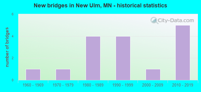
- New bridges - historical statistics
- 11960-1969
- 11970-1979
- 41980-1989
- 41990-1999
- 12000-2009
- 52010-2019
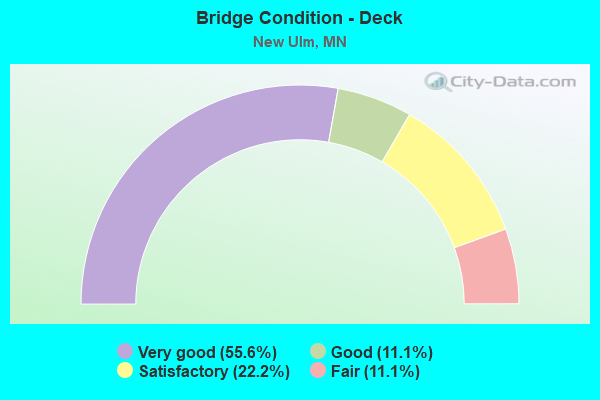
- Bridge Condition - Deck
- 55.6%Very good
- 11.1%Good
- 22.2%Satisfactory
- 11.1%Fair
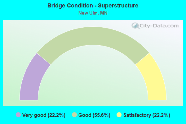
- Bridge Condition - Superstructure
- 22.2%Very good
- 55.6%Good
- 22.2%Satisfactory

- Bridge Condition - Substructure
- 33.3%Very good
- 55.6%Good
- 11.1%Fair
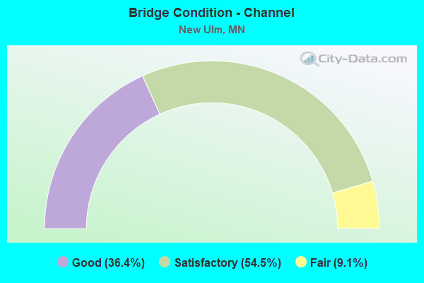
- Bridge Condition - Channel
- 36.4%Good
- 54.5%Satisfactory
- 9.1%Fair
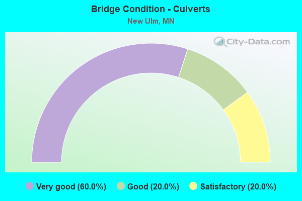
- Bridge Condition - Culverts
- 60.0%Very good
- 20.0%Good
- 20.0%Satisfactory
Find on map >> Show street view
Structure Number: 801, Location: 3.1 MI S OF W JCT TH 14 (Lat: 44.282275, Lng: -94.435622), Route carried "on" structure: State highway 15, Year Built: 1983, Status: Open, Structure Length: 15.51m (50.89ft), Average Daily Traffic: 6,226 (year 2019), Truck Traffic: 11%, Average Future Daily Traffic: 6,200 (year 2039), Design Load: HS 20, Features Intersected: COTTONWOOD RIVER
Minimum Vertical Clearance: 30+ m (98+ ft), Kilometerpoint: 0.000, Lanes on structure: 3, Base Highway Network: Yes, Owner: State Highway Agency, Approaching Roadway Width: 15.9m (52.2ft), Material/Design: Prestressed concrete, Design/Construction: Stringer/Multi-beam, Number Of Spans In Main Unit: 4, Length of Maximum Span: 38.6m (126.6ft), Curb or Sidewalk Widths: Left: 0.0m, Right: 1.9m (6.2ft), Curb-To-Curb Width: 16.7m (54.8ft), Out-to-Out Width: 19.8m (65.0ft)
Condition: Deck: Fair, Superstructure: Satisfactory, Substructure: Fair, Channel: Fair, Operating Rating: 81.3 metric tons, Method Used To Determine Operating Rating: Load Factor (LF), Inventory Rating: 34.9 metric tons, Method Used To Determine Inventory Rating: Load Factor (LF), Structural Evaluation: Somewhat better than minimum adequacy, Deck Geometry: Superior to present desirable criteria, Waterway Adequacy: Superior to present desirable criteria, Approach Roadway Alignment: Equal to present desirable criteria, Designated Inspection Frequency: Every 24 months, Underwater Inspection Frequency: Every 60 months, Inspection Date: June 2021, Underwater Inspection Date: October 2020, Deck Structure Type: Concrete Cast-file-Place, Wearing Surface/Protective System: Wearing Surface: Low Slump Concrete, Deck Protection: Epoxy Coated Reinforcing
Find on map >> Show street view
Structure Number: 8016, Location: 0.8 MI E OF S JCT TH 15 (Lat: 44.324800, Lng: -94.453600), Route carried "on" structure: US 14, Year Built: 2019, Status: Open, Structure Length: 17.20m (56.43ft), Average Daily Traffic: 8,637 (year 2019), Truck Traffic: 6%, Average Future Daily Traffic: 10,650 (year 2039), Design Load: HL 93, Features Intersected: MINNESOTA RIVER
Minimum Vertical Clearance: 30+ m (98+ ft), Kilometerpoint: 0.000, Lanes on structure: 2, Base Highway Network: Yes, Owner: State Highway Agency, Approaching Roadway Width: 12.2m (40.0ft), Material/Design: Prestressed concrete, Design/Construction: Stringer/Multi-beam, Number Of Spans In Main Unit: 5, Length of Maximum Span: 34.2m (112.2ft), Curb or Sidewalk Widths: Left: 3.7m (12.1ft), Right: 0.0m, Curb-To-Curb Width: 12.2m (40.0ft), Out-to-Out Width: 17.2m (56.4ft)
Condition: Deck: Good, Superstructure: Good, Substructure: Very good, Channel: Satisfactory, Operating Rating: 47.6 metric tons, Method Used To Determine Operating Rating: Load and Resistance Factor Rating (LRFR) rating reported by rating factor(RF) method using HL-93 loadings, Inventory Rating: 36.9 metric tons, Method Used To Determine Inventory Rating: Load and Resistance Factor Rating (LRFR) rating reported by rating factor(RF) method using HL-93 loadings, Structural Evaluation: Better than present minimum criteria, Deck Geometry: Somewhat better than minimum adequacy, Waterway Adequacy: Superior to present desirable criteria, Approach Roadway Alignment: Equal to present desirable criteria, Designated Inspection Frequency: Every 24 months, Underwater Inspection Frequency: Every 60 months, Inspection Date: August 2021, Underwater Inspection Date: October 2020, Deck Structure Type: Concrete Cast-file-Place, Wearing Surface/Protective System: Wearing Surface: Monolithic Concrete, Deck Protection: Epoxy Coated Reinforcing
Find on map >> Show street view
Structure Number: 8017, Location: 0.4 MI NE OF JCT TH 15 (Lat: 44.322425, Lng: -94.461036), Route carried "on" structure: US 14, Year Built: 2018, Status: Open, Structure Length: 19.09m (62.63ft), Average Daily Traffic: 8,637 (year 2019), Truck Traffic: 6%, Average Future Daily Traffic: 8,600 (year 2039), Design Load: HL 93, Features Intersected: FRONT ST; CP RR
Minimum Vertical Clearance: 30+ m (98+ ft), Kilometerpoint: 0.000, Lanes on structure: 2, Lanes under structure: 2, Base Highway Network: Yes, Owner: State Highway Agency, Approaching Roadway Width: 12.2m (40.0ft), Material/Design: Prestressed concrete, Design/Construction: Stringer/Multi-beam, Number Of Spans In Main Unit: 5, Length of Maximum Span: 44.0m (144.4ft), Curb or Sidewalk Widths: Left: 3.7m (12.1ft), Right: 0.0m, Curb-To-Curb Width: 12.2m (40.0ft), Out-to-Out Width: 17.2m (56.4ft)
Condition: Deck: Very good, Superstructure: Good, Substructure: Very good, Operating Rating: 49.9 metric tons, Method Used To Determine Operating Rating: Load and Resistance Factor Rating (LRFR) rating reported by rating factor(RF) method using HL-93 loadings, Inventory Rating: 36.3 metric tons, Method Used To Determine Inventory Rating: Load and Resistance Factor Rating (LRFR) rating reported by rating factor(RF) method using HL-93 loadings, Structural Evaluation: Better than present minimum criteria, Deck Geometry: Somewhat better than minimum adequacy, Underclear: Equal to present desirable criteria, Approach Roadway Alignment: Equal to present desirable criteria, Designated Inspection Frequency: Every 24 months, Inspection Date: October 2020, Deck Structure Type: Concrete Cast-file-Place, Wearing Surface/Protective System: Wearing Surface: Monolithic Concrete, Deck Protection: Epoxy Coated Reinforcing
Find on map >> Show street view
Structure Number: 8512, Location: 0.3 MI S OF JCT CSAH 26 (Lat: 44.292975, Lng: -94.481972), Route carried "on" structure: County highway 13, Year Built: 1969, Status: Open, Structure Length: 9.79m (32.12ft), Average Daily Traffic: 2,200 (year 2014), Average Future Daily Traffic: 2,200 (year 2039), Design Load: H 20, Features Intersected: BIG COTTONWOOD RIVER
Minimum Vertical Clearance: 30+ m (98+ ft), Kilometerpoint: 0.000, Lanes on structure: 2, Owner: County Highway Agency, Approaching Roadway Width: 9.8m (32.2ft), Skew: 2 degrees, Material/Design: Prestressed concrete, Design/Construction: Stringer/Multi-beam, Number Of Spans In Main Unit: 4, Length of Maximum Span: 24.1m (79.1ft), Curb-To-Curb Width: 11.0m (36.1ft), Out-to-Out Width: 12.3m (40.4ft)
Condition: Deck: Very good, Superstructure: Good, Substructure: Good, Channel: Good, Operating Rating: 46.3 metric tons, Method Used To Determine Operating Rating: Load and Resistance Factor Rating (LRFR) rating reported by rating factor(RF) method using HL-93 loadings, Inventory Rating: 31.4 metric tons, Method Used To Determine Inventory Rating: Load and Resistance Factor Rating (LRFR) rating reported by rating factor(RF) method using HL-93 loadings, Structural Evaluation: Better than present minimum criteria, Deck Geometry: Somewhat better than minimum adequacy, Approach Roadway Alignment: Equal to present desirable criteria, Designated Inspection Frequency: Every 24 months, Inspection Date: November 2020, Deck Structure Type: Concrete Cast-file-Place, Wearing Surface/Protective System: Wearing Surface: Monolithic Concrete
Find on map >> Show street view
Structure Number: 852, Location: 600 EAST OF VALLEY ST (Lat: 44.297011, Lng: -94.433511), Route carried "on" structure: City street 110, Year Built: 1978, Year Reconstructed: 2015, Status: Open, Structure Length: 17.50m (57.41ft), Average Daily Traffic: 6,924 (year 2015), Average Future Daily Traffic: 5,700 (year 2029), Design Load: HS 20, Features Intersected: MINNESOTA RIVER
Minimum Vertical Clearance: 30+ m (98+ ft), Kilometerpoint: 0.000, Lanes on structure: 4, Owner: City or Municipal Highway Agency, Approaching Roadway Width: 14.6m (47.9ft), Material/Design: Steel continuous, Design/Construction: Stringer/Multi-beam, Number Of Spans In Main Unit: 4, Length of Maximum Span: 48.2m (158.1ft), Curb or Sidewalk Widths: Left: 1.8m (5.9ft), Right: 0.0m, Curb-To-Curb Width: 16.2m (53.1ft), Out-to-Out Width: 19.0m (62.3ft)
Condition: Deck: Very good, Superstructure: Good, Substructure: Good, Channel: Satisfactory, Operating Rating: 64.9 metric tons, Method Used To Determine Operating Rating: Load Factor (LF), Inventory Rating: 38.8 metric tons, Method Used To Determine Inventory Rating: Load Factor (LF), Structural Evaluation: Better than present minimum criteria, Deck Geometry: Meets minimum limits, Waterway Adequacy: Equal to present desirable criteria, Approach Roadway Alignment: Equal to present desirable criteria, Designated Inspection Frequency: Every 24 months, Underwater Inspection Frequency: Every 60 months, Inspection Date: September 2021, Underwater Inspection Date: October 2020, Deck Structure Type: Concrete Cast-file-Place, Wearing Surface/Protective System: Wearing Surface: Monolithic Concrete
Find on map >> Show street view
Structure Number: 8527, Location: AT N CO LINE (Lat: 44.361611, Lng: -94.498153), Route carried "on" structure: County highway 14, Year Built: 1987, Status: Open, Structure Length: 18.25m (59.88ft), Average Daily Traffic: 1,850 (year 2011), Average Future Daily Traffic: 1,850 (year 2039), Design Load: HS 20, Features Intersected: MINNESOTA RIVER
Minimum Vertical Clearance: 30+ m (98+ ft), Kilometerpoint: 0.000, Lanes on structure: 2, Owner: County Highway Agency, Approaching Roadway Width: 12.2m (40.0ft), Material/Design: Steel continuous, Design/Construction: Stringer/Multi-beam, Number Of Spans In Main Unit: 8, Length of Maximum Span: 44.2m (145.0ft), Curb-To-Curb Width: 12.2m (40.0ft), Out-to-Out Width: 13.2m (43.3ft)
Condition: Deck: Satisfactory, Superstructure: Good, Substructure: Good, Channel: Satisfactory, Operating Rating: 44.8 metric tons, Method Used To Determine Operating Rating: Load Factor (LF), Inventory Rating: 26.8 metric tons, Method Used To Determine Inventory Rating: Load Factor (LF), Structural Evaluation: Equal to present minimum criteria, Deck Geometry: Better than present minimum criteria, Approach Roadway Alignment: Equal to present desirable criteria, Designated Inspection Frequency: Every 24 months, Underwater Inspection Frequency: Every 60 months, Inspection Date: November 2020, Underwater Inspection Date: October 2020, Deck Structure Type: Concrete Cast-file-Place, Wearing Surface/Protective System: Wearing Surface: Monolithic Concrete, Deck Protection: Epoxy Coated Reinforcing
Find on map >> Show street view
Structure Number: 8529, Location: 0.1 MI SW OF JCT TH 15 (Lat: 44.289258, Lng: -94.439111), Route carried "on" structure: City street 165, Year Built: 1994, Status: Open, Structure Length: 5.78m (18.96ft), Average Daily Traffic: 201 (year 1994), Average Future Daily Traffic: 201 (year 2029), Design Load: HS 25 or greater, Features Intersected: COTTONWOOD RIVER
Minimum Vertical Clearance: 30+ m (98+ ft), Kilometerpoint: 0.000, Lanes on structure: 2, Owner: City or Municipal Highway Agency, Approaching Roadway Width: 12.2m (40.0ft), Material/Design: Prestressed concrete, Design/Construction: Stringer/Multi-beam, Number Of Spans In Main Unit: 3, Length of Maximum Span: 19.3m (63.3ft), Curb or Sidewalk Widths: Left: 0.0m, Right: 1.8m (5.9ft), Curb-To-Curb Width: 12.2m (40.0ft), Out-to-Out Width: 14.9m (48.9ft)
Condition: Deck: Very good, Superstructure: Very good, Substructure: Good, Channel: Good, Operating Rating: 68.6 metric tons, Method Used To Determine Operating Rating: Load Factor (LF), Inventory Rating: 41.2 metric tons, Method Used To Determine Inventory Rating: Load Factor (LF), Structural Evaluation: Better than present minimum criteria, Deck Geometry: Superior to present desirable criteria, Waterway Adequacy: Meets minimum limits, Approach Roadway Alignment: Equal to present desirable criteria, Designated Inspection Frequency: Every 24 months, Inspection Date: September 2021, Deck Structure Type: Concrete Cast-file-Place, Wearing Surface/Protective System: Wearing Surface: Monolithic Concrete, Deck Protection: Epoxy Coated Reinforcing
Find on map >> Show street view
Structure Number: 8533, Location: 0.8 MI SE OF JCT CSAH 12 (Lat: 44.338600, Lng: -94.507806), Route carried "on" structure: County highway 29, Year Built: 1988, Status: Open, Structure Length: 7.46m (24.48ft), Average Daily Traffic: 5,300 (year 2014), Average Future Daily Traffic: 5,300 (year 2039), Design Load: HS 20, Features Intersected: DM E RR
Minimum Vertical Clearance: 30+ m (98+ ft), Kilometerpoint: 0.000, Lanes on structure: 2, Owner: County Highway Agency, Approaching Roadway Width: 12.2m (40.0ft), Skew: 6 degrees, Material/Design: Steel continuous, Design/Construction: Stringer/Multi-beam, Number Of Spans In Main Unit: 3, Length of Maximum Span: 27.4m (89.9ft), Curb-To-Curb Width: 12.2m (40.0ft), Out-to-Out Width: 13.2m (43.3ft)
Condition: Deck: Satisfactory, Superstructure: Satisfactory, Substructure: Good, Operating Rating: 64.9 metric tons, Method Used To Determine Operating Rating: Load Factor (LF), Inventory Rating: 38.8 metric tons, Method Used To Determine Inventory Rating: Load Factor (LF), Structural Evaluation: Equal to present minimum criteria, Deck Geometry: Somewhat better than minimum adequacy, Underclear: Equal to present desirable criteria, Approach Roadway Alignment: Equal to present desirable criteria, Designated Inspection Frequency: Every 24 months, Inspection Date: November 2020, Deck Structure Type: Concrete Cast-file-Place, Wearing Surface/Protective System: Wearing Surface: Monolithic Concrete, Deck Protection: Epoxy Coated Reinforcing
Find on map >> Show street view
Structure Number: 52016, Location: AT JCT TH 14 AND TH 15 (Lat: 44.324969, Lng: -94.441017), Route carried "on" structure: State highway 15, Year Built: 2019, Status: Open, Structure Length: 3.62m (11.88ft), Average Daily Traffic: 5,683 (year 2019), Truck Traffic: 10%, Average Future Daily Traffic: 4,150 (year 2035), Design Load: HL 93, Features Intersected: US 14
Minimum Vertical Clearance: 30+ m (98+ ft), Kilometerpoint: 0.000, Lanes on structure: 2, Lanes under structure: 2, Base Highway Network: Yes, Owner: State Highway Agency, Approaching Roadway Width: 13.4m (44.0ft), Skew: 23 degrees, Material/Design: Prestressed concrete, Design/Construction: Stringer/Multi-beam, Number Of Spans In Main Unit: 1, Length of Maximum Span: 34.4m (112.9ft), Curb-To-Curb Width: 13.4m (44.0ft), Out-to-Out Width: 14.4m (47.2ft)
Condition: Deck: Very good, Superstructure: Very good, Substructure: Very good, Operating Rating: 43.4 metric tons, Method Used To Determine Operating Rating: Load and Resistance Factor Rating (LRFR) rating reported by rating factor(RF) method using HL-93 loadings, Inventory Rating: 33.4 metric tons, Method Used To Determine Inventory Rating: Load and Resistance Factor Rating (LRFR) rating reported by rating factor(RF) method using HL-93 loadings, Structural Evaluation: Equal to present desirable criteria, Deck Geometry: Equal to present minimum criteria, Underclear: Equal to present minimum criteria, Approach Roadway Alignment: Equal to present desirable criteria, Designated Inspection Frequency: Every 24 months, Inspection Date: August 2021, Deck Structure Type: Concrete Cast-file-Place, Wearing Surface/Protective System: Wearing Surface: Monolithic Concrete, Deck Protection: Epoxy Coated Reinforcing
Find on map >> Show street view
Structure Number: 52J17, Location: 0.7 MI S OF JCT CSAH 5 (Lat: 44.356278, Lng: -94.431600), Route carried "on" structure: County highway 76, Year Built: 2004, Status: Open, Structure Length: 1.22m (4.00ft), Average Daily Traffic: 50 (year 2004), Average Future Daily Traffic: 50 (year 2029), Design Load: HS 25 or greater, Features Intersected: FRITSCHE CREEK
Minimum Vertical Clearance: 30+ m (98+ ft), Kilometerpoint: 0.000, Lanes on structure: 2, Owner: Town or Township Highway Agency, Approaching Roadway Width: 7.3m (24.0ft), Material/Design: Concrete, Design/Construction: Culvert, Number Of Spans In Main Unit: 3, Length of Maximum Span: 3.7m (12.1ft)
Condition: Channel: Satisfactory, Culverts: Very good, Operating Rating: 58.8 metric tons, Method Used To Determine Operating Rating: Assigned rating based on Load Factor Design (LFD) reported in metric tons, Inventory Rating: 39.2 metric tons, Method Used To Determine Inventory Rating: Assigned rating based on Load Factor Design (LFD) reported in metric tons, Structural Evaluation: Equal to present desirable criteria, Waterway Adequacy: Equal to present desirable criteria, Approach Roadway Alignment: Equal to present desirable criteria, Length Of Structure Improvement: 0.52m (1.71ft), Designated Inspection Frequency: Every 48 months, Inspection Date: November 2019, Bridge Improvement Cost: $134,000,000, Roadway Improvement Cost: $1,000, Total Project Cost: $1,000
Find on map >> Show street view
Structure Number: 9592, Location: 2.9 MI NW OF JCT TH 15 (Lat: 44.355511, Lng: -94.479728), Route carried "on" structure: County highway 21, Year Built: 1996, Status: Open, Structure Length: 0.90m (2.95ft), Average Daily Traffic: 960 (year 2011), Average Future Daily Traffic: 960 (year 2039), Design Load: HS 25 or greater, Features Intersected: HUELSKAMP CREEK
Minimum Vertical Clearance: 30+ m (98+ ft), Kilometerpoint: 0.000, Lanes on structure: 2, Owner: County Highway Agency, Approaching Roadway Width: 12.2m (40.0ft), Skew: 3 degrees, Material/Design: Concrete, Design/Construction: Culvert, Number Of Spans In Main Unit: 2, Length of Maximum Span: 3.5m (11.5ft)
Condition: Channel: Good, Culverts: Very good, Operating Rating: 58.8 metric tons, Method Used To Determine Operating Rating: Assigned rating based on Load Factor Design (LFD) reported in metric tons, Inventory Rating: 39.2 metric tons, Method Used To Determine Inventory Rating: Assigned rating based on Load Factor Design (LFD) reported in metric tons, Structural Evaluation: Equal to present desirable criteria, Waterway Adequacy: Equal to present desirable criteria, Approach Roadway Alignment: Equal to present desirable criteria, Designated Inspection Frequency: Every 48 months, Inspection Date: October 2021
Find on map >> Show street view
Structure Number: 96175, Location: 0.4 MI E OF JCT TH 14 (Lat: 44.304603, Lng: -94.415364), Route carried "on" structure: County highway 92, Year Built: 1988, Status: Open, Structure Length: 0.76m (2.49ft), Average Daily Traffic: 55 (year 1988), Average Future Daily Traffic: 55 (year 2029), Design Load: HS 20, Features Intersected: HEYMANS CREEK (CD #83)
Minimum Vertical Clearance: 30+ m (98+ ft), Kilometerpoint: 0.000, Lanes on structure: 2, Owner: Town or Township Highway Agency, Approaching Roadway Width: 7.3m (24.0ft), Material/Design: Concrete, Design/Construction: Culvert, Number Of Spans In Main Unit: 2, Length of Maximum Span: 3.0m (9.8ft)
Condition: Channel: Good, Culverts: Very good, Operating Rating: 68.6 metric tons, Method Used To Determine Operating Rating: Assigned rating based on Load Factor Design (LFD) reported in metric tons, Inventory Rating: 40.8 metric tons, Method Used To Determine Inventory Rating: Assigned rating based on Load Factor Design (LFD) reported in metric tons, Structural Evaluation: Equal to present desirable criteria, Waterway Adequacy: Equal to present desirable criteria, Approach Roadway Alignment: Equal to present desirable criteria, Designated Inspection Frequency: Every 48 months, Inspection Date: November 2019
Find on map >> Show street view
Structure Number: 96916, Location: 2.6 MI E OF N JCT TH 15 (Lat: 44.293444, Lng: -94.413881), Route carried "on" structure: US 14, Year Built: 1990, Status: Open, Structure Length: 0.74m (2.43ft), Average Daily Traffic: 8,600 (year 2019), Truck Traffic: 12%, Average Future Daily Traffic: 7,500 (year 2039), Design Load: HS 25 or greater, Features Intersected: HEYMANS CREEK
Minimum Vertical Clearance: 30+ m (98+ ft), Kilometerpoint: 0.000, Lanes on structure: 2, Base Highway Network: Yes, Owner: State Highway Agency, Approaching Roadway Width: 12.2m (40.0ft), Skew: 2 degrees, Material/Design: Concrete, Design/Construction: Culvert, Number Of Spans In Main Unit: 2, Length of Maximum Span: 3.2m (10.5ft)
Condition: Channel: Satisfactory, Culverts: Satisfactory, Operating Rating: 39.2 metric tons, Method Used To Determine Operating Rating: Assigned rating based on Load Factor Design (LFD) reported in metric tons, Inventory Rating: 29.4 metric tons, Method Used To Determine Inventory Rating: Assigned rating based on Load Factor Design (LFD) reported in metric tons, Structural Evaluation: Equal to present minimum criteria, Waterway Adequacy: Superior to present desirable criteria, Approach Roadway Alignment: Equal to present desirable criteria, Designated Inspection Frequency: Every 24 months, Inspection Date: September 2020
Find on map >> Show street view
Structure Number: 97767, Location: 2.0 MI NW OF JCT TH 15 (Lat: 44.347131, Lng: -94.464408), Route carried "on" structure: County highway 21, Year Built: 1994, Status: Open, Structure Length: 0.78m (2.56ft), Average Daily Traffic: 960 (year 2011), Average Future Daily Traffic: 960 (year 2039), Design Load: HS 25 or greater, Features Intersected: FRITSCHE CREEK
Minimum Vertical Clearance: 30+ m (98+ ft), Kilometerpoint: 0.000, Lanes on structure: 2, Owner: County Highway Agency, Approaching Roadway Width: 12.2m (40.0ft), Material/Design: Concrete, Design/Construction: Culvert, Number Of Spans In Main Unit: 2, Length of Maximum Span: 3.0m (9.8ft)
Condition: Channel: Satisfactory, Culverts: Good, Operating Rating: 58.8 metric tons, Method Used To Determine Operating Rating: Assigned rating based on Load Factor Design (LFD) reported in metric tons, Inventory Rating: 39.2 metric tons, Method Used To Determine Inventory Rating: Assigned rating based on Load Factor Design (LFD) reported in metric tons, Structural Evaluation: Better than present minimum criteria, Waterway Adequacy: Equal to present desirable criteria, Approach Roadway Alignment: Equal to present desirable criteria, Designated Inspection Frequency: Every 48 months, Inspection Date: October 2021
Find on map >> Show street view
Structure Number: 8017, Location: 0.4 MI NE OF JCT TH 15 (Lat: 44.322425, Lng: -94.461036), Route carried "under" structure: City street 111, Year Built: 2018, Structure Length: 0. m, Average Daily Traffic: 3,600 (year 2010), Features Intersected: FRONT ST; CP RR, Facility Carried by Structure: US 14
Minimum Vertical Clearance: 11.34m (37.20ft), Kilometerpoint: 0.000, Lanes under structure: 2, Material/Design: Prestressed concrete, Design/Construction: Stringer/Multi-beam, Length of Maximum Span: 44.0m (144.4ft)
Find on map >> Show street view
Structure Number: 52016, Location: AT JCT TH 14 AND TH 15 (Lat: 44.324969, Lng: -94.441017), Route carried "under" structure: US 14, Year Built: 2019, Structure Length: 0. m, Average Daily Traffic: 8,637 (year 2019), Truck Traffic: 6%, Features Intersected: US 14, Facility Carried by Structure: MN 15
Minimum Vertical Clearance: 5.12m (16.80ft), Kilometerpoint: 0.000, Lanes under structure: 2, Material/Design: Prestressed concrete, Design/Construction: Stringer/Multi-beam, Length of Maximum Span: 34.4m (112.9ft)