Bridge Statistics for Naugatuck, Connecticut (CT)
Condition, Traffic, Stress, Structural Evaluation, Project Costs
- National Bridge Inventory (NBI) Statistics
- 42Number of bridges
- 433ft / 132mTotal length
- 633,664Total average daily traffic
- 38,008Total average daily truck traffic
- National Bridge Inventory (NBI) Registered Bridges for Naugatuck
- No street view available for this location
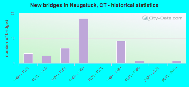
- New bridges - historical statistics
- 41930-1939
- 31940-1949
- 61950-1959
- 181960-1969
- 91980-1989
- 11990-1999
- 12010-2019

- Reconstructed bridges - Historical Statistics
- 51980-1989
- 61990-1999
- 22000-2009
- 12010-2019


- Bridge Condition - Deck
- 11.1%Very good
- 55.6%Good
- 33.3%Satisfactory

- Bridge Condition - Superstructure
- 3.3%Very good
- 50.0%Good
- 30.0%Satisfactory
- 16.7%Fair

- Bridge Condition - Substructure
- 66.7%Good
- 26.7%Satisfactory
- 6.7%Fair

- Bridge Condition - Channel
- 8.3%Very good
- 16.7%Good
- 54.2%Satisfactory
- 20.8%Fair

- Bridge Condition - Culverts
- 33.3%Good
- 66.7%Satisfactory
Find on map >> Show street view
Structure Number: 212, Location: 0.5 MI N OF US ROUTE 1 (Lat: 41.288406, Lng: -72.626333), Route carried "on" structure: City street , Year Built: 1957, Status: Open, Structure Length: 4.75m (15.58ft), Average Daily Traffic: 3,927 (year 2019), Truck Traffic: 5%, Average Future Daily Traffic: 5,835 (year 2039), Design Load: HS 20, Features Intersected: INTERSTATE-95, Facility Carried by Structure: MUNGERTOWN ROAD
Minimum Vertical Clearance: 30+ m (98+ ft), Kilometerpoint: 0.917, Lanes on structure: 2, Lanes under structure: 4, Owner: State Highway Agency, Approaching Roadway Width: 12.2m (40.0ft), Material/Design: Steel, Design/Construction: Stringer/Multi-beam, Number Of Spans In Main Unit: 2, Length of Maximum Span: 22.9m (75.1ft), Curb or Sidewalk Widths: Left: 1.5m (4.9ft), Right: 0.5m (1.6ft), Curb-To-Curb Width: 12.2m (40.0ft), Out-to-Out Width: 15.0m (49.2ft)
Condition: Deck: Satisfactory, Superstructure: Satisfactory, Substructure: Good, Operating Rating: 47.0 metric tons, Method Used To Determine Operating Rating: Load and Resistance Factor Rating (LRFR) rating reported by rating factor(RF) method using HL-93 loadings, Inventory Rating: 36.3 metric tons, Method Used To Determine Inventory Rating: Load and Resistance Factor Rating (LRFR) rating reported by rating factor(RF) method using HL-93 loadings, Structural Evaluation: Equal to present minimum criteria, Deck Geometry: Equal to present minimum criteria, Underclear: High priority of corrective action, Approach Roadway Alignment: Better than present minimum criteria, Designated Inspection Frequency: Every 24 months, Inspection Date: August 2020, Deck Structure Type: Concrete Cast-file-Place, Wearing Surface/Protective System: Wearing Surface: Bituminous, Membrane: Preformed Fabric
Find on map >> Show street view
Structure Number: 213, Location: 0.9 MI S OF ROUTE 79 (Lat: 41.288186, Lng: -72.619839), Route carried "on" structure: Interstate 95, Year Built: 1957, Status: Open, Structure Length: 0.64m (2.10ft), Average Daily Traffic: 72,100 (year 2017), Truck Traffic: 10%, Average Future Daily Traffic: 107,133 (year 2037), Design Load: H 20, Features Intersected: NECK RIVER
Minimum Vertical Clearance: 30+ m (98+ ft), Kilometerpoint: 102.692, Lanes on structure: 4, Base Highway Network: Yes, Owner: State Highway Agency, Approaching Roadway Width: 29.6m (97.1ft), Skew: 30 degrees, Material/Design: Concrete continuous, Design/Construction: Culvert, Number Of Spans In Main Unit: 2, Length of Maximum Span: 3.0m (9.8ft)
Condition: Channel: Good, Culverts: Good, Operating Rating: 45.4 metric tons, Method Used To Determine Operating Rating: Load and Resistance Factor Rating (LRFR) rating reported by rating factor(RF) method using HL-93 loadings, Inventory Rating: 35.0 metric tons, Method Used To Determine Inventory Rating: Load and Resistance Factor Rating (LRFR) rating reported by rating factor(RF) method using HL-93 loadings, Structural Evaluation: Better than present minimum criteria, Waterway Adequacy: Better than present minimum criteria, Approach Roadway Alignment: Equal to present desirable criteria, Designated Inspection Frequency: Every 48 months, Inspection Date: April 2021
Find on map >> Show street view
Structure Number: 59, Location: 1.2 MI NO BEACON FALLS TL (Lat: 41.485642, Lng: -73.051256), Route carried "on" structure: State highway 8, Year Built: 1960, Year Reconstructed: 1990, Status: Open, Structure Length: 2.07m (6.79ft), Average Daily Traffic: 42,400 (year 2018), Truck Traffic: 6%, Average Future Daily Traffic: 63,002 (year 2038), Design Load: HS 20, Features Intersected: ROUTE 63
Minimum Vertical Clearance: 30+ m (98+ ft), Kilometerpoint: 40.668, Lanes on structure: 4, Lanes under structure: 4, Base Highway Network: Yes, Owner: State Highway Agency, Approaching Roadway Width: 22.6m (74.1ft), Skew: 31 degrees, Material/Design: Steel, Design/Construction: Stringer/Multi-beam, Number Of Spans In Main Unit: 1, Length of Maximum Span: 19.2m (63.0ft), Curb-To-Curb Width: 22.6m (74.1ft), Out-to-Out Width: 24.9m (81.7ft)
Condition: Deck: Good, Superstructure: Satisfactory, Substructure: Good, Operating Rating: 56.1 metric tons, Method Used To Determine Operating Rating: Load and Resistance Factor Rating (LRFR) rating reported by rating factor(RF) method using HL-93 loadings, Inventory Rating: 43.1 metric tons, Method Used To Determine Inventory Rating: Load and Resistance Factor Rating (LRFR) rating reported by rating factor(RF) method using HL-93 loadings, Structural Evaluation: Equal to present minimum criteria, Deck Geometry: Superior to present desirable criteria, Underclear: High priority of corrective action, Approach Roadway Alignment: Equal to present desirable criteria, Designated Inspection Frequency: Every 24 months, Inspection Date: September 2021, Deck Structure Type: Concrete Cast-file-Place, Wearing Surface/Protective System: Wearing Surface: Bituminous, Membrane: Preformed Fabric, Deck Protection: Epoxy Coated Reinforcing
Find on map >> Show street view
Structure Number: 592A, Location: ROUTE 8 EXIT 27 (Lat: 41.490692, Lng: -73.051472), Route carried "on" structure: State highway 8, Year Built: 1960, Year Reconstructed: 1990, Status: Open, Structure Length: 25.69m (84.28ft), Average Daily Traffic: 51,500 (year 2018), Truck Traffic: 6%, Average Future Daily Traffic: 76,524 (year 2038), Design Load: HS 20, Features Intersected: MAPLE & OAK ST, RAMP 063
Minimum Vertical Clearance: 30+ m (98+ ft), Kilometerpoint: 41.087, Lanes on structure: 4, Lanes under structure: 5, Base Highway Network: Yes, Owner: State Highway Agency, Approaching Roadway Width: 22.6m (74.1ft), Skew: 30 degrees, Material/Design: Steel, Design/Construction: Stringer/Multi-beam, Number Of Spans In Main Unit: 10, Length of Maximum Span: 26.2m (86.0ft), Curb-To-Curb Width: 19.2m (63.0ft), Out-to-Out Width: 21.1m (69.2ft)
Condition: Deck: Satisfactory, Superstructure: Fair, Substructure: Fair, Operating Rating: 69.8 metric tons, Method Used To Determine Operating Rating: Load Factor (LF), Inventory Rating: 41.7 metric tons, Method Used To Determine Inventory Rating: Load Factor (LF), Structural Evaluation: Somewhat better than minimum adequacy, Deck Geometry: Somewhat better than minimum adequacy, Underclear: High priority of corrective action, Approach Roadway Alignment: Equal to present desirable criteria, Designated Inspection Frequency: Every 24 months, Critical Feature Inspection Frequency: Every 24 months, Inspection Date: May 2021, Critical Feature Inspection Date: May 2021, Deck Structure Type: Concrete Cast-file-Place, Wearing Surface/Protective System: Wearing Surface: Bituminous, Membrane: Preformed Fabric, Deck Protection: Epoxy Coated Reinforcing
Find on map >> Show street view
Structure Number: 592B, Location: EXIT 27, ROUTE 8 S.B. (Lat: 41.491075, Lng: -73.051494), Route carried "on" structure: Ramp State highway 8, Year Built: 1960, Year Reconstructed: 1990, Status: Open, Structure Length: 16.58m (54.40ft), Average Daily Traffic: 6,283 (year 2021), Truck Traffic: 6%, Average Future Daily Traffic: 9,336 (year 2041), Design Load: HS 20, Features Intersected: NAUGATUCK RIVER FLOOD PL
Minimum Vertical Clearance: 30+ m (98+ ft), Kilometerpoint: 42.503, Lanes on structure: 1, Owner: State Highway Agency, Approaching Roadway Width: 7.3m (24.0ft), Material/Design: Steel, Design/Construction: Stringer/Multi-beam, Number Of Spans In Main Unit: 7, Length of Maximum Span: 24.7m (81.0ft), Curb or Sidewalk Widths: Left: 1.4m (4.6ft), Right: 0.0m, Curb-To-Curb Width: 7.3m (24.0ft), Out-to-Out Width: 10.1m (33.1ft)
Condition: Deck: Good, Superstructure: Satisfactory, Substructure: Fair, Operating Rating: 91.0 metric tons, Method Used To Determine Operating Rating: Load Factor (LF), Inventory Rating: 54.6 metric tons, Method Used To Determine Inventory Rating: Load Factor (LF), Structural Evaluation: Somewhat better than minimum adequacy, Deck Geometry: Better than present minimum criteria, Approach Roadway Alignment: Equal to present minimum criteria, Designated Inspection Frequency: Every 24 months, Inspection Date: May 2021, Deck Structure Type: Concrete Cast-file-Place, Wearing Surface/Protective System: Wearing Surface: Bituminous, Membrane: Preformed Fabric, Deck Protection: Epoxy Coated Reinforcing
Find on map >> Show street view
Structure Number: 594, Location: AT EXIT 28 (Lat: 41.501372, Lng: -73.047736), Route carried "on" structure: State highway 8, Year Built: 1960, Year Reconstructed: 1989, Status: Open, Structure Length: 1.68m (5.51ft), Average Daily Traffic: 51,400 (year 2018), Truck Traffic: 5%, Average Future Daily Traffic: 76,375 (year 2038), Design Load: HS 20, Features Intersected: ROUTE 8 SB ON RAMP
Minimum Vertical Clearance: 30+ m (98+ ft), Kilometerpoint: 42.535, Lanes on structure: 4, Lanes under structure: 1, Base Highway Network: Yes, Owner: State Highway Agency, Approaching Roadway Width: 22.6m (74.1ft), Skew: 34 degrees, Material/Design: Steel, Design/Construction: Stringer/Multi-beam, Number Of Spans In Main Unit: 1, Length of Maximum Span: 15.2m (49.9ft), Curb-To-Curb Width: 22.5m (73.8ft), Out-to-Out Width: 24.6m (80.7ft)
Condition: Deck: Satisfactory, Superstructure: Good, Substructure: Satisfactory, Operating Rating: 78.9 metric tons, Method Used To Determine Operating Rating: Load Factor (LF), Inventory Rating: 47.2 metric tons, Method Used To Determine Inventory Rating: Load Factor (LF), Structural Evaluation: Equal to present minimum criteria, Deck Geometry: Superior to present desirable criteria, Underclear: High priority of corrective action, Approach Roadway Alignment: Equal to present desirable criteria, Designated Inspection Frequency: Every 24 months, Inspection Date: June 2020, Deck Structure Type: Concrete Cast-file-Place, Wearing Surface/Protective System: Wearing Surface: Bituminous, Membrane: Preformed Fabric, Deck Protection: Epoxy Coated Reinforcing
Find on map >> Show street view
Structure Number: 596, Location: RT 68 OVER RTE 8,METRO N. (Lat: 41.502633, Lng: -73.047525), Route carried "on" structure: State highway 68, Year Built: 1960, Year Reconstructed: 2018, Status: Open, Structure Length: 17.01m (55.81ft), Average Daily Traffic: 14,100 (year 2018), Truck Traffic: 6%, Average Future Daily Traffic: 20,951 (year 2038), Design Load: HL 93, Features Intersected: NAUG RV,RTE 8,MNRR,SR710
Minimum Vertical Clearance: 30+ m (98+ ft), Kilometerpoint: 0.724, Lanes on structure: 2, Lanes under structure: 6, Owner: State Highway Agency, Approaching Roadway Width: 15.2m (49.9ft), Material/Design: Steel continuous, Design/Construction: Stringer/Multi-beam, Number Of Spans In Main Unit: 6, Length of Maximum Span: 30.5m (100.1ft), Curb or Sidewalk Widths: Left: 1.5m (4.9ft), Right: 1.5m (4.9ft), Curb-To-Curb Width: 15.5m (50.9ft), Out-to-Out Width: 19.7m (64.6ft)
Condition: Deck: Good, Superstructure: Good, Substructure: Good, Channel: Very good, Operating Rating: 52.2 metric tons, Method Used To Determine Operating Rating: Load and Resistance Factor Rating (LRFR) rating reported by rating factor(RF) method using HL-93 loadings, Inventory Rating: 40.2 metric tons, Method Used To Determine Inventory Rating: Load and Resistance Factor Rating (LRFR) rating reported by rating factor(RF) method using HL-93 loadings, Structural Evaluation: Better than present minimum criteria, Deck Geometry: Superior to present desirable criteria, Underclear: High priority of corrective action, Waterway Adequacy: Superior to present desirable criteria, Approach Roadway Alignment: Equal to present desirable criteria, Designated Inspection Frequency: Every 24 months, Inspection Date: March 2020, Deck Structure Type: Concrete Cast-file-Place, Wearing Surface/Protective System: Wearing Surface: Bituminous, Membrane: Built-up, Deck Protection: Epoxy Coated Reinforcing
Find on map >> Show street view
Structure Number: 775, Location: 2.3 MI S OF ROUTE 10 (Lat: 41.352231, Lng: -72.961769), Route carried "on" structure: City street , Year Built: 1949, Year Reconstructed: 1990, Status: Open, Structure Length: 4.51m (14.80ft), Average Daily Traffic: 6,000 (year 2018), Truck Traffic: 4%, Average Future Daily Traffic: 8,915 (year 2038), Design Load: HS 20, Features Intersected: ROUTE 15, Facility Carried by Structure: WOODIN STREET
Minimum Vertical Clearance: 30+ m (98+ ft), Kilometerpoint: 0.257, Lanes on structure: 2, Lanes under structure: 4, Owner: State Highway Agency, Approaching Roadway Width: 13.4m (44.0ft), Skew: 1 degrees, Material/Design: Steel continuous, Design/Construction: Stringer/Multi-beam, Number Of Spans In Main Unit: 2, Length of Maximum Span: 21.9m (71.9ft), Curb-To-Curb Width: 13.5m (44.3ft), Out-to-Out Width: 14.6m (47.9ft)
Condition: Deck: Satisfactory, Superstructure: Satisfactory, Substructure: Satisfactory, Operating Rating: 35.6 metric tons, Method Used To Determine Operating Rating: Load and Resistance Factor Rating (LRFR) rating reported by rating factor(RF) method using HL-93 loadings, Inventory Rating: 27.5 metric tons, Method Used To Determine Inventory Rating: Load and Resistance Factor Rating (LRFR) rating reported by rating factor(RF) method using HL-93 loadings, Structural Evaluation: Equal to present minimum criteria, Deck Geometry: Superior to present desirable criteria, Underclear: High priority of corrective action, Approach Roadway Alignment: Better than present minimum criteria, Designated Inspection Frequency: Every 24 months, Inspection Date: July 2021, Deck Structure Type: Concrete Cast-file-Place, Wearing Surface/Protective System: Wearing Surface: Bituminous, Membrane: Built-up, Deck Protection: Epoxy Coated Reinforcing
Find on map >> Show street view
Structure Number: 1034, Location: 0.1 MI N OF RTE 8 EXIT 26 (Lat: 41.484464, Lng: -73.053903), Route carried "on" structure: State highway 63, Year Built: 2011, Status: Open, Structure Length: 17.96m (58.92ft), Average Daily Traffic: 18,900 (year 2018), Truck Traffic: 6%, Average Future Daily Traffic: 28,084 (year 2038), Design Load: HS 20, Features Intersected: NAUGATUCK RV, MNRR & ELM
Minimum Vertical Clearance: 30+ m (98+ ft), Kilometerpoint: 23.335, Lanes on structure: 4, Lanes under structure: 2, Base Highway Network: Yes, Owner: State Highway Agency, Approaching Roadway Width: 15.9m (52.2ft), Material/Design: Steel continuous, Design/Construction: Stringer/Multi-beam, Number Of Spans In Main Unit: 4, Length of Maximum Span: 61.0m (200.1ft), Curb or Sidewalk Widths: Left: 1.8m (5.9ft), Right: 0.0m, Curb-To-Curb Width: 15.9m (52.2ft), Out-to-Out Width: 18.6m (61.0ft)
Condition: Deck: Good, Superstructure: Good, Substructure: Good, Channel: Very good, Operating Rating: 74.8 metric tons, Method Used To Determine Operating Rating: Load and Resistance Factor Rating (LRFR) rating reported by rating factor(RF) method using HL-93 loadings, Inventory Rating: 57.7 metric tons, Method Used To Determine Inventory Rating: Load and Resistance Factor Rating (LRFR) rating reported by rating factor(RF) method using HL-93 loadings, Structural Evaluation: Better than present minimum criteria, Deck Geometry: Meets minimum limits, Underclear: Meets minimum limits, Waterway Adequacy: Equal to present desirable criteria, Approach Roadway Alignment: Equal to present minimum criteria, Designated Inspection Frequency: Every 24 months, Inspection Date: May 2021, Deck Structure Type: Concrete Cast-file-Place, Wearing Surface/Protective System: Wearing Surface: Bituminous, Membrane: Preformed Fabric, Deck Protection: Epoxy Coated Reinforcing
Find on map >> Show street view
Structure Number: 1035, Location: 0.5 MILE SOUTH OF ROUTE 8 (Lat: 41.486308, Lng: -73.057783), Route carried "on" structure: State highway 63, Year Built: 1961, Year Reconstructed: 2000, Status: Open, Structure Length: 1.01m (3.31ft), Average Daily Traffic: 14,200 (year 2018), Truck Traffic: 4%, Average Future Daily Traffic: 21,100 (year 2038), Design Load: HS 20, Features Intersected: LONG MEADOW BROOK
Minimum Vertical Clearance: 30+ m (98+ ft), Kilometerpoint: 23.915, Lanes on structure: 2, Base Highway Network: Yes, Owner: State Highway Agency, Approaching Roadway Width: 12.2m (40.0ft), Material/Design: Concrete, Design/Construction: Slab, Number Of Spans In Main Unit: 1, Length of Maximum Span: 9.1m (29.9ft), Curb or Sidewalk Widths: Left: 1.8m (5.9ft), Right: 1.8m (5.9ft), Curb-To-Curb Width: 12.2m (40.0ft), Out-to-Out Width: 16.6m (54.5ft)
Condition: Deck: Good, Superstructure: Fair, Substructure: Good, Channel: Satisfactory, Operating Rating: 59.7 metric tons, Method Used To Determine Operating Rating: Load Factor (LF), Inventory Rating: 35.8 metric tons, Method Used To Determine Inventory Rating: Load Factor (LF), Structural Evaluation: Somewhat better than minimum adequacy, Deck Geometry: Somewhat better than minimum adequacy, Waterway Adequacy: Equal to present minimum criteria, Approach Roadway Alignment: Better than present minimum criteria, Designated Inspection Frequency: Every 24 months, Inspection Date: October 2021, Deck Structure Type: Concrete Cast-file-Place, Wearing Surface/Protective System: Wearing Surface: Bituminous, Membrane: Preformed Fabric
Find on map >> Show street view
Structure Number: 1068, Location: 1.0 MI E OF ROUTE 63 (Lat: 41.502192, Lng: -73.038683), Route carried "on" structure: State highway 68, Year Built: 1933, Status: Open, Structure Length: 0.85m (2.79ft), Average Daily Traffic: 12,300 (year 2018), Truck Traffic: 3%, Average Future Daily Traffic: 18,277 (year 2038), Design Load: H 20, Features Intersected: FULLING MILL BROOK
Minimum Vertical Clearance: 30+ m (98+ ft), Kilometerpoint: 1.625, Lanes on structure: 2, Owner: State Highway Agency, Approaching Roadway Width: 9.8m (32.2ft), Skew: 3 degrees, Material/Design: Steel, Design/Construction: Stringer/Multi-beam, Number Of Spans In Main Unit: 1, Length of Maximum Span: 7.6m (24.9ft), Curb or Sidewalk Widths: Left: 0.3m (1.0ft), Right: 0.3m (1.0ft), Curb-To-Curb Width: 9.1m (29.9ft), Out-to-Out Width: 10.7m (35.1ft)
Condition: Deck: Satisfactory, Superstructure: Satisfactory, Substructure: Satisfactory, Channel: Good, Operating Rating: 76.9 metric tons, Method Used To Determine Operating Rating: Load Factor (LF), Inventory Rating: 46.2 metric tons, Method Used To Determine Inventory Rating: Load Factor (LF), Structural Evaluation: Equal to present minimum criteria, Deck Geometry: High priority of corrective action, Waterway Adequacy: Equal to present minimum criteria, Approach Roadway Alignment: Better than present minimum criteria, Designated Inspection Frequency: Every 24 months, Inspection Date: September 2020, Deck Structure Type: Concrete Cast-file-Place, Wearing Surface/Protective System: Wearing Surface: Bituminous, Membrane: Preformed Fabric
Find on map >> Show street view
Structure Number: 1069, Location: 1.3 MI E OF ROUTE 63 (Lat: 41.504428, Lng: -73.034347), Route carried "on" structure: State highway 68, Year Built: 1933, Status: Open, Structure Length: 0.79m (2.59ft), Average Daily Traffic: 12,300 (year 2018), Truck Traffic: 3%, Average Future Daily Traffic: 18,277 (year 2038), Design Load: H 20, Features Intersected: FULLING MILL BROOK
Minimum Vertical Clearance: 30+ m (98+ ft), Kilometerpoint: 2.060, Lanes on structure: 2, Owner: State Highway Agency, Approaching Roadway Width: 9.1m (29.9ft), Skew: 2 degrees, Material/Design: Concrete, Design/Construction: Slab, Number Of Spans In Main Unit: 1, Length of Maximum Span: 7.3m (24.0ft), Curb or Sidewalk Widths: Left: 0.3m (1.0ft), Right: 0.3m (1.0ft), Curb-To-Curb Width: 9.1m (29.9ft), Out-to-Out Width: 10.7m (35.1ft)
Condition: Deck: Satisfactory, Superstructure: Satisfactory, Substructure: Satisfactory, Channel: Satisfactory, Operating Rating: 75.8 metric tons, Method Used To Determine Operating Rating: Load Factor (LF), Inventory Rating: 45.5 metric tons, Method Used To Determine Inventory Rating: Load Factor (LF), Structural Evaluation: Equal to present minimum criteria, Deck Geometry: High priority of corrective action, Waterway Adequacy: Equal to present minimum criteria, Approach Roadway Alignment: Better than present minimum criteria, Designated Inspection Frequency: Every 24 months, Inspection Date: September 2020, Deck Structure Type: Concrete Cast-file-Place, Wearing Surface/Protective System: Wearing Surface: Bituminous, Membrane: Preformed Fabric
Find on map >> Show street view
Structure Number: 1636, Location: 150 FT SOUTH OF ROUTE 68 (Lat: 41.501731, Lng: -73.046086), Route carried "on" structure: State highway 723, Year Built: 1959, Year Reconstructed: 1992, Status: Open, Structure Length: 1.22m (4.00ft), Average Daily Traffic: 10,200 (year 2011), Truck Traffic: 3%, Average Future Daily Traffic: 15,156 (year 2031), Design Load: HS 20, Features Intersected: FULLING MILL BROOK
Minimum Vertical Clearance: 30+ m (98+ ft), Kilometerpoint: 0.080, Lanes on structure: 3, Owner: State Highway Agency, Approaching Roadway Width: 11.0m (36.1ft), Skew: 3 degrees, Material/Design: Steel, Design/Construction: Stringer/Multi-beam, Number Of Spans In Main Unit: 1, Length of Maximum Span: 10.4m (34.1ft), Curb or Sidewalk Widths: Left: 1.7m (5.6ft), Right: 1.7m (5.6ft), Curb-To-Curb Width: 11.0m (36.1ft), Out-to-Out Width: 15.1m (49.5ft)
Condition: Deck: Good, Superstructure: Good, Substructure: Good, Channel: Satisfactory, Operating Rating: 49.6 metric tons, Method Used To Determine Operating Rating: Load and Resistance Factor Rating (LRFR) rating reported by rating factor(RF) method using HL-93 loadings, Inventory Rating: 38.2 metric tons, Method Used To Determine Inventory Rating: Load and Resistance Factor Rating (LRFR) rating reported by rating factor(RF) method using HL-93 loadings, Structural Evaluation: Better than present minimum criteria, Deck Geometry: High priority of replacement, Waterway Adequacy: Equal to present desirable criteria, Approach Roadway Alignment: Equal to present desirable criteria, Designated Inspection Frequency: Every 24 months, Inspection Date: October 2020, Deck Structure Type: Concrete Cast-file-Place, Wearing Surface/Protective System: Wearing Surface: Latex Concrete, Deck Protection: Cathodic Protection
Find on map >> Show street view
Structure Number: 1657, Location: 0.04 MI SO. OF EXIT 28 SB (Lat: 41.502081, Lng: -73.046850), Route carried "on" structure: State highway 710, Year Built: 1998, Status: Open, Structure Length: 0.91m (2.99ft), Average Daily Traffic: 4,400 (year 2018), Truck Traffic: 3%, Average Future Daily Traffic: 6,538 (year 2038), Design Load: HS 20, Features Intersected: FULLING MILL BROOK
Minimum Vertical Clearance: 30+ m (98+ ft), Kilometerpoint: 0.064, Lanes on structure: 2, Owner: State Highway Agency, Approaching Roadway Width: 11.9m (39.0ft), Material/Design: Prestressed concrete, Design/Construction: Slab, Number Of Spans In Main Unit: 1, Length of Maximum Span: 8.2m (26.9ft), Curb or Sidewalk Widths: Left: 1.5m (4.9ft), Right: 1.5m (4.9ft), Curb-To-Curb Width: 11.9m (39.0ft), Out-to-Out Width: 15.5m (50.9ft)
Condition: Deck: Very good, Superstructure: Good, Substructure: Good, Channel: Satisfactory, Operating Rating: 83.7 metric tons, Method Used To Determine Operating Rating: Load Factor (LF), Inventory Rating: 53.8 metric tons, Method Used To Determine Inventory Rating: Load Factor (LF), Structural Evaluation: Better than present minimum criteria, Deck Geometry: Somewhat better than minimum adequacy, Waterway Adequacy: Equal to present minimum criteria, Approach Roadway Alignment: Equal to present desirable criteria, Designated Inspection Frequency: Every 24 months, Inspection Date: October 2021, Deck Structure Type: Other, Wearing Surface/Protective System: Wearing Surface: Bituminous, Membrane: Built-up, Deck Protection: Epoxy Coated Reinforcing
Find on map >> Show street view
Structure Number: 3175, Location: 0.1 MILE NORTH OF EXIT 29 (Lat: 41.513342, Lng: -73.048672), Route carried "on" structure: State highway 8, Year Built: 1965, Year Reconstructed: 1995, Status: Open, Structure Length: 7.35m (24.11ft), Average Daily Traffic: 50,700 (year 2018), Truck Traffic: 6%, Average Future Daily Traffic: 75,335 (year 2038), Design Load: HS 20, Features Intersected: SR 847 - SOUTH MAIN ST.
Minimum Vertical Clearance: 30+ m (98+ ft), Kilometerpoint: 43.919, Lanes on structure: 4, Lanes under structure: 3, Base Highway Network: Yes, Owner: State Highway Agency, Approaching Roadway Width: 25.6m (84.0ft), Skew: 35 degrees, Material/Design: Steel, Design/Construction: Stringer/Multi-beam, Number Of Spans In Main Unit: 3, Length of Maximum Span: 40.8m (133.9ft), Curb or Sidewalk Widths: Left: 0.5m (1.6ft), Right: 0.5m (1.6ft), Curb-To-Curb Width: 25.7m (84.3ft), Out-to-Out Width: 27.9m (91.5ft)
Condition: Deck: Satisfactory, Superstructure: Satisfactory, Substructure: Good, Operating Rating: 46.3 metric tons, Method Used To Determine Operating Rating: Load and Resistance Factor Rating (LRFR) rating reported by rating factor(RF) method using HL-93 loadings, Inventory Rating: 35.6 metric tons, Method Used To Determine Inventory Rating: Load and Resistance Factor Rating (LRFR) rating reported by rating factor(RF) method using HL-93 loadings, Structural Evaluation: Equal to present minimum criteria, Deck Geometry: Superior to present desirable criteria, Underclear: Somewhat better than minimum adequacy, Approach Roadway Alignment: Equal to present desirable criteria, Designated Inspection Frequency: Every 24 months, Inspection Date: June 2020, Deck Structure Type: Concrete Cast-file-Place, Wearing Surface/Protective System: Wearing Surface: Bituminous, Membrane: Preformed Fabric
Find on map >> Show street view
Structure Number: 3595, Location: 0.7 MI WEST OF BOLTON T.L (Lat: 41.768014, Lng: -72.480733), Route carried "on" structure: Interstate 384, Year Built: 1968, Status: Open, Structure Length: 4.05m (13.29ft), Average Daily Traffic: 15,850 (year 2018), Truck Traffic: 14%, Average Future Daily Traffic: 23,552 (year 2038), Design Load: HS 20, Features Intersected: SR 534 (CAMP MEETING RD)
Minimum Vertical Clearance: 30+ m (98+ ft), Kilometerpoint: 10.235, Lanes on structure: 3, Lanes under structure: 2, Base Highway Network: Yes, Owner: State Highway Agency, Approaching Roadway Width: 16.8m (55.1ft), Skew: 5 degrees, Material/Design: Steel, Design/Construction: Stringer/Multi-beam, Number Of Spans In Main Unit: 1, Length of Maximum Span: 37.8m (124.0ft), Curb or Sidewalk Widths: Left: 0.2m (0.7ft), Right: 0.2m (0.7ft), Curb-To-Curb Width: 16.8m (55.1ft), Out-to-Out Width: 17.8m (58.4ft)
Condition: Deck: Satisfactory, Superstructure: Satisfactory, Substructure: Good, Inventory Rating: 64.5 metric tons, Method Used To Determine Inventory Rating: Load Factor (LF), Structural Evaluation: Equal to present minimum criteria, Deck Geometry: Equal to present minimum criteria, Underclear: Equal to present minimum criteria, Approach Roadway Alignment: Equal to present desirable criteria, Designated Inspection Frequency: Every 24 months, Inspection Date: June 2020, Deck Structure Type: Concrete Cast-file-Place, Wearing Surface/Protective System: Wearing Surface: Bituminous, Membrane: Preformed Fabric
Find on map >> Show street view
Structure Number: 4388, Location: AT EXIT 25 (Lat: 41.468956, Lng: -73.051339), Route carried "on" structure: State highway 8, Year Built: 1981, Status: Open, Structure Length: 3.99m (13.09ft), Average Daily Traffic: 45,300 (year 2015), Truck Traffic: 5%, Average Future Daily Traffic: 67,311 (year 2035), Design Load: HS 20, Features Intersected: CROSS ROAD
Minimum Vertical Clearance: 30+ m (98+ ft), Kilometerpoint: 38.721, Lanes on structure: 4, Lanes under structure: 2, Base Highway Network: Yes, Owner: State Highway Agency, Approaching Roadway Width: 29.3m (96.1ft), Skew: 31 degrees, Material/Design: Steel, Design/Construction: Stringer/Multi-beam, Number Of Spans In Main Unit: 1, Length of Maximum Span: 38.4m (126.0ft), Curb-To-Curb Width: 29.3m (96.1ft), Out-to-Out Width: 31.0m (101.7ft)
Condition: Deck: Good, Superstructure: Good, Substructure: Good, Operating Rating: 92.5 metric tons, Method Used To Determine Operating Rating: Load Factor (LF), Inventory Rating: 55.3 metric tons, Method Used To Determine Inventory Rating: Load Factor (LF), Structural Evaluation: Better than present minimum criteria, Deck Geometry: Superior to present desirable criteria, Underclear: Somewhat better than minimum adequacy, Approach Roadway Alignment: Equal to present desirable criteria, Designated Inspection Frequency: Every 24 months, Inspection Date: January 2021, Deck Structure Type: Concrete Cast-file-Place, Wearing Surface/Protective System: Wearing Surface: Bituminous, Membrane: Preformed Fabric
Find on map >> Show street view
Structure Number: 4389, Location: AT EXIT 25, RTE 8 (Lat: 41.468489, Lng: -73.051372), Route carried "on" structure: State highway 8, Year Built: 1981, Status: Open, Structure Length: 1.28m (4.20ft), Average Daily Traffic: 45,300 (year 2015), Truck Traffic: 5%, Average Future Daily Traffic: 67,311 (year 2035), Features Intersected: BEACON HILL BROOK
Minimum Vertical Clearance: 30+ m (98+ ft), Kilometerpoint: 38.721, Lanes on structure: 6, Base Highway Network: Yes, Owner: State Highway Agency, Approaching Roadway Width: 45.7m (149.9ft), Skew: 39 degrees, Material/Design: Concrete continuous, Design/Construction: Culvert, Number Of Spans In Main Unit: 2, Length of Maximum Span: 5.2m (17.1ft)
Condition: Channel: Satisfactory, Culverts: Satisfactory, Structural Evaluation: Equal to present minimum criteria, Waterway Adequacy: Equal to present minimum criteria, Approach Roadway Alignment: Equal to present desirable criteria, Designated Inspection Frequency: Every 24 months, Inspection Date: November 2021
Find on map >> Show street view
Structure Number: 4901, Location: AT MIDDLEBURY - OXFORD TL (Lat: 41.489286, Lng: -73.104253), Route carried "on" structure: City street , Year Built: 1960, Status: Open, Structure Length: 0.73m (2.40ft), Average Daily Traffic: 955 (year 2012), Truck Traffic: 4%, Average Future Daily Traffic: 1,419 (year 2032), Features Intersected: LONG MEADOW POND BROOK, Facility Carried by Structure: GUNTOWN ROAD
Minimum Vertical Clearance: 30+ m (98+ ft), Kilometerpoint: 0.000, Lanes on structure: 2, Owner: Town or Township Highway Agency, Approaching Roadway Width: 7.6m (24.9ft), Skew: 4 degrees, Material/Design: Steel, Design/Construction: Arch - Deck, Number Of Spans In Main Unit: 1, Length of Maximum Span: 7.3m (24.0ft), Curb-To-Curb Width: 7.5m (24.6ft), Out-to-Out Width: 9.0m (29.5ft)
Condition: Superstructure: Fair, Substructure: Satisfactory, Channel: Satisfactory, Operating Rating: 97.2 metric tons, Method Used To Determine Operating Rating: Load and Resistance Factor Rating (LRFR) rating reported by rating factor(RF) method using HL-93 loadings, Inventory Rating: 97.2 metric tons, Method Used To Determine Inventory Rating: Load and Resistance Factor Rating (LRFR) rating reported by rating factor(RF) method using HL-93 loadings, Structural Evaluation: Somewhat better than minimum adequacy, Deck Geometry: Meets minimum limits, Waterway Adequacy: Better than present minimum criteria, Approach Roadway Alignment: Equal to present desirable criteria, Designated Inspection Frequency: Every 24 months, Inspection Date: October 2020
Find on map >> Show street view
Structure Number: 4902, Location: .1 MI SOUTH OF RUBBER AVE (Lat: 41.486364, Lng: -73.055064), Route carried "on" structure: City street , Year Built: 1955, Status: Open, Structure Length: 1.28m (4.20ft), Average Daily Traffic: 1,825 (year 2012), Truck Traffic: 2%, Average Future Daily Traffic: 2,712 (year 2032), Features Intersected: LONG MEADOW POND BROOK, Facility Carried by Structure: ELM STREET
Minimum Vertical Clearance: 30+ m (98+ ft), Kilometerpoint: 0.000, Lanes on structure: 2, Owner: Town or Township Highway Agency, Approaching Roadway Width: 9.1m (29.9ft), Material/Design: Steel, Design/Construction: Arch - Deck, Number Of Spans In Main Unit: 2, Length of Maximum Span: 6.1m (20.0ft), Curb or Sidewalk Widths: Left: 1.8m (5.9ft), Right: 0.0m, Curb-To-Curb Width: 9.8m (32.2ft), Out-to-Out Width: 12.1m (39.7ft)
Condition: Superstructure: Fair, Substructure: Satisfactory, Channel: Fair, Operating Rating: 54.4 metric tons, Method Used To Determine Operating Rating: Field evaluation and documented engineering judgment, Inventory Rating: 32.7 metric tons, Method Used To Determine Inventory Rating: Field evaluation and documented engineering judgment, Structural Evaluation: Somewhat better than minimum adequacy, Deck Geometry: Somewhat better than minimum adequacy, Waterway Adequacy: Better than present minimum criteria, Approach Roadway Alignment: Equal to present desirable criteria, Designated Inspection Frequency: Every 24 months, Inspection Date: October 2020
Find on map >> Show street view
Structure Number: 4903, Location: .1 MI EAST OF ROUTE 63 (Lat: 41.505911, Lng: -73.058308), Route carried "on" structure: City street , Year Built: 1940, Year Reconstructed: 2002, Status: Open, Structure Length: 1.68m (5.51ft), Average Daily Traffic: 2,920 (year 2012), Truck Traffic: 2%, Average Future Daily Traffic: 4,339 (year 2032), Design Load: HS 20, Features Intersected: HOP BROOK, Facility Carried by Structure: PORTER AVENUE
Minimum Vertical Clearance: 30+ m (98+ ft), Kilometerpoint: 0.000, Lanes on structure: 2, Owner: Town or Township Highway Agency, Approaching Roadway Width: 8.5m (27.9ft), Material/Design: Concrete, Design/Construction: Arch - Deck, Number Of Spans In Main Unit: 1, Length of Maximum Span: 16.8m (55.1ft), Curb or Sidewalk Widths: Left: 0.0m, Right: 2.6m (8.5ft), Curb-To-Curb Width: 8.5m (27.9ft), Out-to-Out Width: 13.0m (42.7ft)
Condition: Superstructure: Satisfactory, Substructure: Good, Channel: Good, Operating Rating: 82.3 metric tons, Method Used To Determine Operating Rating: Load Factor (LF), Inventory Rating: 49.3 metric tons, Method Used To Determine Inventory Rating: Load Factor (LF), Structural Evaluation: Equal to present minimum criteria, Deck Geometry: Meets minimum limits, Waterway Adequacy: Equal to present minimum criteria, Approach Roadway Alignment: Equal to present desirable criteria, Designated Inspection Frequency: Every 24 months, Inspection Date: October 2020, Wearing Surface/Protective System: Wearing Surface: Bituminous, Membrane: Built-up
Find on map >> Show street view
Structure Number: 4907, Location: OVER LONG MEADOW POND BRK (Lat: 41.496781, Lng: -73.089078), Route carried "on" structure: City street , Year Built: 1956, Year Reconstructed: 2007, Status: Open, Structure Length: 1.62m (5.31ft), Average Daily Traffic: 3,142 (year 2010), Truck Traffic: 4%, Average Future Daily Traffic: 4,669 (year 2030), Design Load: HS 20, Features Intersected: LONG MEADOW POND BROOK, Facility Carried by Structure: RUBBER AVENUE EXT.
Minimum Vertical Clearance: 30+ m (98+ ft), Kilometerpoint: 0.306, Lanes on structure: 2, Owner: Town or Township Highway Agency, Approaching Roadway Width: 9.8m (32.2ft), Skew: 4 degrees, Material/Design: Prestressed concrete, Design/Construction: Box Beam or Girders - Multiple, Number Of Spans In Main Unit: 1, Length of Maximum Span: 15.5m (50.9ft), Curb or Sidewalk Widths: Left: 0.0m, Right: 1.8m (5.9ft), Curb-To-Curb Width: 9.8m (32.2ft), Out-to-Out Width: 12.6m (41.3ft)
Condition: Deck: Good, Superstructure: Good, Substructure: Good, Channel: Good, Operating Rating: 98.3 metric tons, Method Used To Determine Operating Rating: Load Factor (LF), Inventory Rating: 58.9 metric tons, Method Used To Determine Inventory Rating: Load Factor (LF), Structural Evaluation: Better than present minimum criteria, Deck Geometry: Meets minimum limits, Waterway Adequacy: Superior to present desirable criteria, Approach Roadway Alignment: Equal to present minimum criteria, Designated Inspection Frequency: Every 48 months, Inspection Date: October 2018, Deck Structure Type: Other, Wearing Surface/Protective System: Wearing Surface: Bituminous, Membrane: Built-up, Deck Protection: Epoxy Coated Reinforcing
Find on map >> Show street view
Structure Number: 5245, Location: JCT HOADLEY ST &RUBBER AV (Lat: 41.489158, Lng: -73.068172), Route carried "on" structure: City street , Year Built: 1983, Status: Open, Structure Length: 1.07m (3.51ft), Average Daily Traffic: 14,600 (year 2012), Truck Traffic: 5%, Average Future Daily Traffic: 21,694 (year 2032), Design Load: HS 20, Features Intersected: LONG MEADOW POND BROOK, Facility Carried by Structure: RUBBER AVENUE
Minimum Vertical Clearance: 30+ m (98+ ft), Kilometerpoint: 0.000, Lanes on structure: 2, Owner: Town or Township Highway Agency, Approaching Roadway Width: 14.6m (47.9ft), Skew: 1 degrees, Material/Design: Prestressed concrete, Design/Construction: Slab, Number Of Spans In Main Unit: 1, Length of Maximum Span: 10.4m (34.1ft), Curb or Sidewalk Widths: Left: 1.5m (4.9ft), Right: 2.1m (6.9ft), Curb-To-Curb Width: 14.7m (48.2ft), Out-to-Out Width: 18.4m (60.4ft)
Condition: Deck: Satisfactory, Superstructure: Good, Substructure: Good, Channel: Fair, Operating Rating: 91.6 metric tons, Method Used To Determine Operating Rating: Load Factor (LF), Inventory Rating: 54.4 metric tons, Method Used To Determine Inventory Rating: Load Factor (LF), Structural Evaluation: Better than present minimum criteria, Deck Geometry: Superior to present desirable criteria, Waterway Adequacy: Better than present minimum criteria, Approach Roadway Alignment: Equal to present desirable criteria, Designated Inspection Frequency: Every 24 months, Inspection Date: September 2020, Deck Structure Type: Other, Wearing Surface/Protective System: Wearing Surface: Bituminous
Find on map >> Show street view
Structure Number: 5246, Location: AT NAUGATUCK HIGH SCHOOL (Lat: 41.490494, Lng: -73.073658), Route carried "on" structure: City street , Year Built: 1983, Status: Open, Structure Length: 1.31m (4.30ft), Average Daily Traffic: 6,900 (year 2009), Truck Traffic: 5%, Average Future Daily Traffic: 10,253 (year 2029), Design Load: HS 20, Features Intersected: LONG MEADOW POND BROOK, Facility Carried by Structure: RUBBER AVENUE
Minimum Vertical Clearance: 30+ m (98+ ft), Kilometerpoint: 0.000, Lanes on structure: 3, Owner: Town or Township Highway Agency, Approaching Roadway Width: 10.4m (34.1ft), Skew: 3 degrees, Material/Design: Prestressed concrete, Design/Construction: Slab, Number Of Spans In Main Unit: 1, Length of Maximum Span: 11.3m (37.1ft), Curb or Sidewalk Widths: Left: 1.5m (4.9ft), Right: 1.5m (4.9ft), Curb-To-Curb Width: 14.7m (48.2ft), Out-to-Out Width: 18.4m (60.4ft)
Condition: Deck: Good, Superstructure: Good, Substructure: Good, Channel: Satisfactory, Operating Rating: 68.0 metric tons, Method Used To Determine Operating Rating: Load Factor (LF), Inventory Rating: 40.8 metric tons, Method Used To Determine Inventory Rating: Load Factor (LF), Structural Evaluation: Better than present minimum criteria, Deck Geometry: Somewhat better than minimum adequacy, Waterway Adequacy: Better than present minimum criteria, Approach Roadway Alignment: Equal to present desirable criteria, Designated Inspection Frequency: Every 48 months, Inspection Date: October 2018, Deck Structure Type: Other, Wearing Surface/Protective System: Wearing Surface: Bituminous
Find on map >> Show street view
Structure Number: 5247, Location: AT NEUMANN STREET (Lat: 41.493533, Lng: -73.081156), Route carried "on" structure: City street , Year Built: 1983, Status: Open, Structure Length: 1.98m (6.50ft), Average Daily Traffic: 3,500 (year 2012), Truck Traffic: 5%, Average Future Daily Traffic: 5,201 (year 2032), Design Load: HS 20, Features Intersected: LONG MEADOW POND BROOK, Facility Carried by Structure: RUBBER AVENUE
Minimum Vertical Clearance: 30+ m (98+ ft), Kilometerpoint: 0.000, Lanes on structure: 3, Owner: Town or Township Highway Agency, Approaching Roadway Width: 12.2m (40.0ft), Skew: 6 degrees, Material/Design: Prestressed concrete, Design/Construction: Box Beam or Girders - Multiple, Number Of Spans In Main Unit: 1, Length of Maximum Span: 19.2m (63.0ft), Curb or Sidewalk Widths: Left: 1.5m (4.9ft), Right: 1.5m (4.9ft), Curb-To-Curb Width: 14.8m (48.6ft), Out-to-Out Width: 18.7m (61.4ft)
Condition: Deck: Good, Superstructure: Fair, Substructure: Good, Channel: Fair, Operating Rating: 95.9 metric tons, Method Used To Determine Operating Rating: Load Factor (LF), Inventory Rating: 55.0 metric tons, Method Used To Determine Inventory Rating: Load Factor (LF), Structural Evaluation: Somewhat better than minimum adequacy, Deck Geometry: Equal to present minimum criteria, Waterway Adequacy: Equal to present minimum criteria, Approach Roadway Alignment: Better than present minimum criteria, Designated Inspection Frequency: Every 24 months, Inspection Date: October 2020, Deck Structure Type: Other, Wearing Surface/Protective System: Wearing Surface: Bituminous
Find on map >> Show street view
Structure Number: 5248, Location: 0.1 MI WEST OF ROUTE 63 (Lat: 41.466889, Lng: -73.016908), Route carried "on" structure: City street , Year Built: 1982, Status: Open, Structure Length: 1.37m (4.49ft), Average Daily Traffic: 979 (year 2010), Truck Traffic: 7%, Average Future Daily Traffic: 1,455 (year 2030), Design Load: HS 20, Features Intersected: BEACON HILL BROOK, Facility Carried by Structure: SCHMITZ AVENUE
Minimum Vertical Clearance: 30+ m (98+ ft), Kilometerpoint: 9.045, Lanes on structure: 2, Owner: Town or Township Highway Agency, Approaching Roadway Width: 7.3m (24.0ft), Skew: 3 degrees, Material/Design: Prestressed concrete, Design/Construction: Slab, Number Of Spans In Main Unit: 1, Length of Maximum Span: 13.1m (43.0ft), Curb or Sidewalk Widths: Left: 1.0m (3.3ft), Right: 2.4m (7.9ft), Curb-To-Curb Width: 7.3m (24.0ft), Out-to-Out Width: 11.5m (37.7ft)
Condition: Deck: Good, Superstructure: Good, Substructure: Good, Channel: Satisfactory, Operating Rating: 41.8 metric tons, Method Used To Determine Operating Rating: Load and Resistance Factor Rating (LRFR) rating reported by rating factor(RF) method using HL-93 loadings, Inventory Rating: 31.4 metric tons, Method Used To Determine Inventory Rating: Load and Resistance Factor Rating (LRFR) rating reported by rating factor(RF) method using HL-93 loadings, Structural Evaluation: Better than present minimum criteria, Deck Geometry: Meets minimum limits, Waterway Adequacy: Better than present minimum criteria, Approach Roadway Alignment: Equal to present desirable criteria, Designated Inspection Frequency: Every 48 months, Inspection Date: October 2018, Deck Structure Type: Other, Wearing Surface/Protective System: Wearing Surface: Bituminous
Find on map >> Show street view
Structure Number: 5249, Location: 350' SO OF ROUTE 63 (Lat: 41.467994, Lng: -73.027119), Route carried "on" structure: City street , Year Built: 1982, Status: Open, Structure Length: 1.31m (4.30ft), Average Daily Traffic: 1,200 (year 2012), Truck Traffic: 4%, Average Future Daily Traffic: 1,783 (year 2032), Design Load: HS 20, Features Intersected: BEACON HILL BROOK, Facility Carried by Structure: BEACON VALLEY RD 1
Minimum Vertical Clearance: 30+ m (98+ ft), Kilometerpoint: 0.000, Lanes on structure: 2, Owner: Town or Township Highway Agency, Approaching Roadway Width: 7.3m (24.0ft), Skew: 2 degrees, Material/Design: Prestressed concrete, Design/Construction: Slab, Number Of Spans In Main Unit: 1, Length of Maximum Span: 12.5m (41.0ft), Curb or Sidewalk Widths: Left: 0.0m, Right: 1.5m (4.9ft), Curb-To-Curb Width: 9.2m (30.2ft), Out-to-Out Width: 11.7m (38.4ft)
Condition: Deck: Very good, Superstructure: Good, Substructure: Good, Channel: Satisfactory, Operating Rating: 53.5 metric tons, Method Used To Determine Operating Rating: Load Factor (LF), Inventory Rating: 31.7 metric tons, Method Used To Determine Inventory Rating: Load Factor (LF), Structural Evaluation: Better than present minimum criteria, Deck Geometry: Somewhat better than minimum adequacy, Waterway Adequacy: Better than present minimum criteria, Approach Roadway Alignment: Equal to present minimum criteria, Designated Inspection Frequency: Every 24 months, Inspection Date: October 2020, Deck Structure Type: Other, Wearing Surface/Protective System: Wearing Surface: Bituminous, Membrane: Preformed Fabric
Find on map >> Show street view
Structure Number: 525, Location: AT JCT OF RUBBER AVE&ARCH (Lat: 41.486392, Lng: -73.059464), Route carried "on" structure: City street , Year Built: 1982, Status: Open, Structure Length: 1.07m (3.51ft), Average Daily Traffic: 1,560 (year 2012), Truck Traffic: 2%, Average Future Daily Traffic: 2,318 (year 2032), Design Load: H 20, Features Intersected: LONG MEADOW POND BROOK, Facility Carried by Structure: ARCH STREET
Minimum Vertical Clearance: 30+ m (98+ ft), Kilometerpoint: 0.000, Lanes on structure: 2, Owner: Town or Township Highway Agency, Approaching Roadway Width: 9.1m (29.9ft), Material/Design: Prestressed concrete, Design/Construction: Slab, Number Of Spans In Main Unit: 1, Length of Maximum Span: 9.8m (32.2ft), Curb or Sidewalk Widths: Left: 1.4m (4.6ft), Right: 1.5m (4.9ft), Curb-To-Curb Width: 9.1m (29.9ft), Out-to-Out Width: 13.0m (42.7ft)
Condition: Deck: Very good, Superstructure: Very good, Substructure: Good, Channel: Fair, Inventory Rating: 68.0 metric tons, Method Used To Determine Inventory Rating: Load Factor (LF), Structural Evaluation: Better than present minimum criteria, Deck Geometry: Somewhat better than minimum adequacy, Waterway Adequacy: Better than present minimum criteria, Approach Roadway Alignment: Equal to present minimum criteria, Designated Inspection Frequency: Every 24 months, Inspection Date: October 2020, Deck Structure Type: Other, Wearing Surface/Protective System: Wearing Surface: Bituminous
Find on map >> Show street view
Structure Number: 5503, Location: 500' SO OF ROUTE 63 JCT (Lat: 41.466500, Lng: -73.008739), Route carried "on" structure: City street , Year Built: 1982, Status: Open, Structure Length: 1.71m (5.61ft), Average Daily Traffic: 660 (year 2010), Truck Traffic: 3%, Average Future Daily Traffic: 981 (year 2030), Design Load: HS 20, Features Intersected: BEACON HILL BROOK, Facility Carried by Structure: BOWMAN DRIVE
Minimum Vertical Clearance: 30+ m (98+ ft), Kilometerpoint: 0.080, Lanes on structure: 2, Owner: Town or Township Highway Agency, Approaching Roadway Width: 9.1m (29.9ft), Skew: 4 degrees, Material/Design: Prestressed concrete, Design/Construction: Box Beam or Girders - Multiple, Number Of Spans In Main Unit: 1, Length of Maximum Span: 13.4m (44.0ft), Curb or Sidewalk Widths: Left: 0.0m, Right: 1.0m (3.3ft), Curb-To-Curb Width: 9.1m (29.9ft), Out-to-Out Width: 11.1m (36.4ft)
Condition: Deck: Good, Superstructure: Good, Substructure: Good, Channel: Satisfactory, Operating Rating: 94.3 metric tons, Method Used To Determine Operating Rating: Load Factor (LF), Inventory Rating: 56.2 metric tons, Method Used To Determine Inventory Rating: Load Factor (LF), Structural Evaluation: Better than present minimum criteria, Deck Geometry: Equal to present minimum criteria, Waterway Adequacy: Better than present minimum criteria, Approach Roadway Alignment: Equal to present desirable criteria, Designated Inspection Frequency: Every 48 months, Inspection Date: October 2018, Deck Structure Type: Other, Wearing Surface/Protective System: Wearing Surface: Bituminous, Membrane: Preformed Fabric
Find on map >> Show street view
Structure Number: 5538, Location: 200 FT SO JCT RUBBER AVE (Lat: 41.486878, Lng: -73.062911), Route carried "on" structure: City street , Year Built: 1931, Year Reconstructed: 1986, Status: Open, Structure Length: 0.94m (3.08ft), Average Daily Traffic: 4,080 (year 2012), Truck Traffic: 5%, Average Future Daily Traffic: 6,062 (year 2032), Design Load: HS 20, Features Intersected: LONG MEADOW POND BROOK, Facility Carried by Structure: ANDREW AVENUE
Minimum Vertical Clearance: 30+ m (98+ ft), Kilometerpoint: 0.000, Lanes on structure: 2, Owner: Town or Township Highway Agency, Approaching Roadway Width: 8.5m (27.9ft), Material/Design: Prestressed concrete, Design/Construction: Slab, Number Of Spans In Main Unit: 1, Length of Maximum Span: 9.1m (29.9ft), Curb or Sidewalk Widths: Left: 1.2m (3.9ft), Right: 0.0m, Curb-To-Curb Width: 8.4m (27.6ft), Out-to-Out Width: 9.7m (31.8ft)
Condition: Deck: Good, Superstructure: Good, Substructure: Satisfactory, Channel: Satisfactory, Operating Rating: 38.2 metric tons, Method Used To Determine Operating Rating: Load and Resistance Factor Rating (LRFR) rating reported by rating factor(RF) method using HL-93 loadings, Inventory Rating: 29.5 metric tons, Method Used To Determine Inventory Rating: Load and Resistance Factor Rating (LRFR) rating reported by rating factor(RF) method using HL-93 loadings, Structural Evaluation: Equal to present minimum criteria, Deck Geometry: High priority of corrective action, Waterway Adequacy: Better than present minimum criteria, Approach Roadway Alignment: Equal to present desirable criteria, Designated Inspection Frequency: Every 24 months, Inspection Date: October 2020, Deck Structure Type: Other, Wearing Surface/Protective System: Wearing Surface: Bituminous
Find on map >> Show street view
Structure Number: 5539, Location: AT TOWN DPW (Lat: 41.489358, Lng: -73.072114), Route carried "on" structure: City street , Year Built: 1955, Year Reconstructed: 1986, Status: Open, Structure Length: 0.85m (2.79ft), Average Daily Traffic: 1,165 (year 2012), Truck Traffic: 3%, Average Future Daily Traffic: 1,731 (year 2032), Design Load: H 20, Features Intersected: LONG MEADOW POND BROOK, Facility Carried by Structure: BROOKSIDE AVENUE
Minimum Vertical Clearance: 30+ m (98+ ft), Kilometerpoint: 0.000, Lanes on structure: 2, Owner: Town or Township Highway Agency, Approaching Roadway Width: 9.1m (29.9ft), Skew: 2 degrees, Material/Design: Prestressed concrete, Design/Construction: Slab, Number Of Spans In Main Unit: 1, Length of Maximum Span: 8.2m (26.9ft), Curb or Sidewalk Widths: Left: 1.4m (4.6ft), Right: 1.4m (4.6ft), Curb-To-Curb Width: 9.3m (30.5ft), Out-to-Out Width: 12.7m (41.7ft)
Condition: Deck: Good, Superstructure: Good, Substructure: Good, Channel: Satisfactory, Operating Rating: 41.8 metric tons, Method Used To Determine Operating Rating: Load and Resistance Factor Rating (LRFR) rating reported by rating factor(RF) method using HL-93 loadings, Inventory Rating: 32.1 metric tons, Method Used To Determine Inventory Rating: Load and Resistance Factor Rating (LRFR) rating reported by rating factor(RF) method using HL-93 loadings, Structural Evaluation: Better than present minimum criteria, Deck Geometry: Somewhat better than minimum adequacy, Waterway Adequacy: Better than present minimum criteria, Approach Roadway Alignment: Equal to present desirable criteria, Designated Inspection Frequency: Every 24 months, Inspection Date: October 2020, Deck Structure Type: Other, Wearing Surface/Protective System: Wearing Surface: Bituminous
Find on map >> Show street view
Structure Number: 5709, Location: AT JUNCTION WITH ROUTE 63 (Lat: 41.499514, Lng: -73.054994), Route carried "on" structure: State highway 68, Year Built: 1933, Year Reconstructed: 1989, Status: Open, Structure Length: 1.46m (4.79ft), Average Daily Traffic: 10,700 (year 2018), Truck Traffic: 4%, Average Future Daily Traffic: 15,899 (year 2038), Design Load: HS 20, Features Intersected: HOP BROOK
Minimum Vertical Clearance: 30+ m (98+ ft), Kilometerpoint: 0.016, Lanes on structure: 3, Owner: State Highway Agency, Approaching Roadway Width: 8.5m (27.9ft), Material/Design: Prestressed concrete, Design/Construction: Box Beam or Girders - Multiple, Number Of Spans In Main Unit: 1, Length of Maximum Span: 14.0m (45.9ft), Curb or Sidewalk Widths: Left: 2.2m (7.2ft), Right: 2.2m (7.2ft), Curb-To-Curb Width: 11.6m (38.1ft), Out-to-Out Width: 16.8m (55.1ft)
Condition: Deck: Good, Superstructure: Good, Substructure: Satisfactory, Channel: Satisfactory, Operating Rating: 67.3 metric tons, Method Used To Determine Operating Rating: Load Factor (LF), Inventory Rating: 40.4 metric tons, Method Used To Determine Inventory Rating: Load Factor (LF), Structural Evaluation: Equal to present minimum criteria, Deck Geometry: High priority of replacement, Waterway Adequacy: Equal to present desirable criteria, Approach Roadway Alignment: Equal to present desirable criteria, Designated Inspection Frequency: Every 24 months, Inspection Date: January 2022, Deck Structure Type: Other, Wearing Surface/Protective System: Wearing Surface: Bituminous, Membrane: Built-up, Deck Protection: Epoxy Coated Reinforcing
Find on map >> Show street view
Structure Number: 6913, Location: .13 mi. north of Route 63 (Lat: 41.469750, Lng: -73.009139), Route carried "on" structure: City street , Year Built: 1940, Status: Open, Structure Length: 0.79m (2.59ft), Average Daily Traffic: 3,100 (year 2012), Truck Traffic: 2%, Average Future Daily Traffic: 4,606 (year 2032), Features Intersected: MARKS BROOK, Facility Carried by Structure: HORTON HILL RD.
Minimum Vertical Clearance: 30+ m (98+ ft), Kilometerpoint: 0.209, Lanes on structure: 2, Owner: Town or Township Highway Agency, Approaching Roadway Width: 8.8m (28.9ft), Skew: 3 degrees, Material/Design: Steel, Design/Construction: Culvert, Number Of Spans In Main Unit: 3, Length of Maximum Span: 2.1m (6.9ft), Curb-To-Curb Width: 9.0m (29.5ft), Out-to-Out Width: 18.3m (60.0ft)
Condition: Channel: Fair, Culverts: Satisfactory, Inventory Rating: 70.5 metric tons, Method Used To Determine Inventory Rating: No rating analysis performed, Structural Evaluation: Equal to present minimum criteria, Deck Geometry: Meets minimum limits, Waterway Adequacy: Better than present minimum criteria, Approach Roadway Alignment: Better than present minimum criteria, Designated Inspection Frequency: Every 24 months, Inspection Date: October 2020, Wearing Surface/Protective System: Wearing Surface: Bituminous
Find on map >> Show street view
Structure Number: 59, Location: 1.2 MI NO BEACON FALLS TL (Lat: 41.485642, Lng: -73.051256), Route carried "under" structure: State highway 63, Year Built: 1960, Structure Length: 0. m, Average Daily Traffic: 16,300 (year 2018), Truck Traffic: 6%, Features Intersected: ROUTE 63, Facility Carried by Structure: ROUTE 8
Minimum Vertical Clearance: 4.52m (14.83ft), Kilometerpoint: 23.175, Lanes on structure: 4, Lanes under structure: 4, Material/Design: Steel, Design/Construction: Stringer/Multi-beam, Length of Maximum Span: 19.2m (63.0ft)
Find on map >> Show street view
Structure Number: 591, Location: AT EXIT 26 ROUTE 8 SB. (Lat: 41.487211, Lng: -73.051728), Route carried "under" structure: ServiceState highway 709, Year Built: 1960, Structure Length: 0. m, Average Daily Traffic: 6,100 (year 2018), Truck Traffic: 5%, Features Intersected: SR 709 SOUTH MAIN STREET, Facility Carried by Structure: ROUTE 8
Minimum Vertical Clearance: 4.32m (14.17ft), Kilometerpoint: 0.161, Lanes on structure: 5, Lanes under structure: 2, Material/Design: Steel, Design/Construction: Stringer/Multi-beam, Length of Maximum Span: 32.9m (107.9ft)
Find on map >> Show street view
Structure Number: 592A, Location: ROUTE 8 EXIT 27 (Lat: 41.490692, Lng: -73.051472), Route carried "under" structure: Ramp State highway 8, Year Built: 1960, Structure Length: 0. m, Average Daily Traffic: 4,300 (year 2018), Truck Traffic: 6%, Features Intersected: MAPLE & OAK ST, RAMP 063
Minimum Vertical Clearance: 4.32m (14.17ft), Kilometerpoint: 0.064, Lanes on structure: 4, Lanes under structure: 1, Material/Design: Steel, Design/Construction: Stringer/Multi-beam, Length of Maximum Span: 26.2m (86.0ft)
Find on map >> Show street view
Structure Number: 593, Location: ROUTE 8 EXIT NO. 27 (Lat: 41.494789, Lng: -73.051122), Route carried "under" structure: Ramp State highway 8, Year Built: 1960, Structure Length: 0. m, Average Daily Traffic: 796 (year 2020), Truck Traffic: 3%, Features Intersected: ROUTE 8 RAMP 064
Minimum Vertical Clearance: 4.42m (14.50ft), Kilometerpoint: 0.257, Lanes on structure: 4, Lanes under structure: 2, Material/Design: Steel, Design/Construction: Stringer/Multi-beam, Length of Maximum Span: 27.1m (88.9ft)
Find on map >> Show street view
Structure Number: 594, Location: AT EXIT 28 (Lat: 41.501372, Lng: -73.047736), Route carried "under" structure: Ramp State highway 8, Year Built: 1960, Structure Length: 0. m, Average Daily Traffic: 4,712 (year 2020), Truck Traffic: 6%, Features Intersected: ROUTE 8 SB ON RAMP
Minimum Vertical Clearance: 4.72m (15.49ft), Kilometerpoint: 0.048, Lanes on structure: 4, Lanes under structure: 1, Material/Design: Steel, Design/Construction: Stringer/Multi-beam, Length of Maximum Span: 15.2m (49.9ft)
Find on map >> Show street view
Structure Number: 596, Location: RT 68 OVER RTE 8,METRO N. (Lat: 41.502633, Lng: -73.047525), Route carried "under" structure: State highway 8, Year Built: 1960, Structure Length: 0. m, Average Daily Traffic: 51,400 (year 2018), Truck Traffic: 6%, Features Intersected: NAUG RV,RTE 8,MNRR,SR710
Minimum Vertical Clearance: 5.87m (19.26ft), Kilometerpoint: 42.648, Lanes on structure: 2, Lanes under structure: 4, Material/Design: Steel continuous, Design/Construction: Stringer/Multi-beam, Length of Maximum Span: 30.5m (100.1ft)
Find on map >> Show street view
Structure Number: 596, Location: RT 68 OVER RTE 8,METRO N. (Lat: 41.502633, Lng: -73.047525), Route carried "under" structure: Ramp State highway 710, Year Built: 1960, Structure Length: 0. m, Average Daily Traffic: 4,400 (year 2018), Truck Traffic: 6%, Features Intersected: NAUG RV,RTE 8,MNRR,SR710, Facility Carried by Structure: ROUTE 68
Minimum Vertical Clearance: 7.34m (24.08ft), Kilometerpoint: 0.097, Lanes on structure: 2, Lanes under structure: 2, Material/Design: Steel continuous, Design/Construction: Stringer/Multi-beam, Length of Maximum Span: 30.5m (100.1ft)
Find on map >> Show street view
Structure Number: 597, Location: EXIT 28 ROUTE 8 SB (Lat: 41.505572, Lng: -73.045675), Route carried "under" structure: Ramp State highway 8, Year Built: 1960, Structure Length: 0. m, Average Daily Traffic: 5,010 (year 2021), Truck Traffic: 6%, Features Intersected: ROUTE 8 RAMP 069
Minimum Vertical Clearance: 4.45m (14.60ft), Kilometerpoint: 0.499, Lanes on structure: 4, Lanes under structure: 1, Material/Design: Steel, Design/Construction: Stringer/Multi-beam, Length of Maximum Span: 18.0m (59.1ft)
Find on map >> Show street view
Structure Number: 3175, Location: 0.1 MILE NORTH OF EXIT 29 (Lat: 41.513342, Lng: -73.048672), Route carried "under" structure: Business State highway 847, Year Built: 1965, Structure Length: 0. m, Average Daily Traffic: 6,200 (year 2018), Truck Traffic: 6%, Features Intersected: SR 847 - SOUTH MAIN ST., Facility Carried by Structure: ROUTE 8
Minimum Vertical Clearance: 4.80m (15.75ft), Kilometerpoint: 0.209, Lanes on structure: 4, Lanes under structure: 3, Material/Design: Steel, Design/Construction: Stringer/Multi-beam, Length of Maximum Span: 40.8m (133.9ft)