Bridge Statistics for Natick, Massachusetts (MA)
Condition, Traffic, Stress, Structural Evaluation, Project Costs
- National Bridge Inventory (NBI) Statistics
- 32Number of bridges
- 207ft / 63.1mTotal length
- $49,488,000Total costs
- 888,222Total average daily traffic
- 44,419Total average daily truck traffic
- National Bridge Inventory (NBI) Registered Bridges for Natick
- No street view available for this location
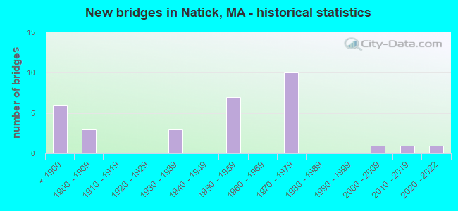
- New bridges - historical statistics
- 6Before 1900
- 31900-1909
- 31930-1939
- 71950-1959
- 101970-1979
- 12000-2009
- 12010-2019
- 12020-2022

- Reconstructed bridges - Historical Statistics
- 11910-1919
- 01920-1929
- 01930-1939
- 11940-1949
- 01950-1959
- 11960-1969
- 01970-1979
- 51980-1989
- 31990-1999
- 02000-2009
- 12010-2019


- Bridge Condition - Deck
- 16.7%Very good
- 11.1%Good
- 27.8%Satisfactory
- 38.9%Fair
- 5.6%Poor

- Bridge Condition - Superstructure
- 15.0%Very good
- 10.0%Good
- 35.0%Satisfactory
- 30.0%Fair
- 10.0%Poor

- Bridge Condition - Substructure
- 5.0%Very good
- 35.0%Good
- 40.0%Satisfactory
- 20.0%Fair

- Bridge Condition - Channel
- 25.0%Very good
- 25.0%Good
- 50.0%Satisfactory

- Bridge Condition - Culverts
- 50.0%Good
- 50.0%Poor
Find on map >> Show street view
Structure Number: N0300224QMUNNBI, Location: .3MI S. OF STATE 16 (Lat: 42.269753, Lng: -71.313872), Route carried "on" structure: City street , Year Built: 1904, Year Reconstructed: 1999, Status: Open, Structure Length: 0.62m (2.03ft), Average Daily Traffic: 13,247 (year 2017), Truck Traffic: 4%, Average Future Daily Traffic: 19,583 (year 2032), Design Load: HS 20, Features Intersected: WATER SEWER CANAL, Facility Carried by Structure: HWY PLEASANT ST
Minimum Vertical Clearance: 30+ m (98+ ft), Kilometerpoint: 0.998, Lanes on structure: 2, Owner: Town or Township Highway Agency, Approaching Roadway Width: 9.8m (32.2ft), Skew: 1 degrees, Material/Design: Steel, Design/Construction: Culvert, Number Of Spans In Main Unit: 3, Length of Maximum Span: 2.1m (6.9ft), Curb or Sidewalk Widths: Left: 1.6m (5.2ft), Right: 1.6m (5.2ft), Curb-To-Curb Width: 9.8m (32.2ft), Out-to-Out Width: 14.2m (46.6ft)
Condition: Channel: Satisfactory, Culverts: Poor, Structural Evaluation: Meets minimum limits, Deck Geometry: Meets minimum limits, Waterway Adequacy: Better than present minimum criteria, Approach Roadway Alignment: Better than present minimum criteria, Length Of Structure Improvement: 1.10m (3.61ft), Designated Inspection Frequency: Every 12 months, Other Special Inspection Frequency: Every 12 months, Inspection Date: November 2021, Other Special Inspection Date: November 2021, Bridge Improvement Cost: $259,000, Roadway Improvement Cost: $26,000, Total Project Cost: $389,000 ( Estimate for 2022)
Find on map >> Show street view
Structure Number: N0300329TDOTNBI, Location: 0.3 MI N RT 135 (Lat: 42.287219, Lng: -71.337908), Route carried "on" structure: City street , Year Built: 1896, Year Reconstructed: 2018, Status: Open, Structure Length: 2.59m (8.50ft), Average Daily Traffic: 6,100 (year 2012), Truck Traffic: 3%, Average Future Daily Traffic: 9,634 (year 2031), Design Load: HL 93, Features Intersected: RR MBTA/CSX, Facility Carried by Structure: HWY MARION ST
Minimum Vertical Clearance: 30+ m (98+ ft), Kilometerpoint: 0.322, Lanes on structure: 2, Owner: State Highway Agency, Approaching Roadway Width: 7.9m (25.9ft), Skew: 4 degrees, Material/Design: Steel, Design/Construction: Stringer/Multi-beam, Number Of Spans In Main Unit: 1, Length of Maximum Span: 25.9m (85.0ft), Curb or Sidewalk Widths: Left: 1.8m (5.9ft), Right: 0.0m, Curb-To-Curb Width: 7.9m (25.9ft), Out-to-Out Width: 10.6m (34.8ft)
Condition: Deck: Very good, Superstructure: Very good, Substructure: Good, Operating Rating: 58.3 metric tons, Method Used To Determine Operating Rating: Load and Resistance Factor Rating (LRFR) rating reported by rating factor(RF) method using HL-93 loadings, Inventory Rating: 45.4 metric tons, Method Used To Determine Inventory Rating: Load and Resistance Factor Rating (LRFR) rating reported by rating factor(RF) method using HL-93 loadings, Structural Evaluation: Better than present minimum criteria, Deck Geometry: High priority of replacement, Underclear: High priority of corrective action, Approach Roadway Alignment: Better than present minimum criteria, Designated Inspection Frequency: Every 24 months, Inspection Date: July 2020, Deck Structure Type: Concrete Cast-file-Place, Wearing Surface/Protective System: Wearing Surface: Bituminous, Membrane: Built-up, Deck Protection: Epoxy Coated Reinforcing
Find on map >> Show street view
Structure Number: N0300429RDOT634, Location: .1 MI. E. OF ST-27 (Lat: 42.285828, Lng: -71.346556), Route carried "on" structure: City street , Year Built: 1895, Year Reconstructed: 1987, Status: Open, Structure Length: 2.77m (9.09ft), Average Daily Traffic: 1,300 (year 2014), Truck Traffic: 4%, Average Future Daily Traffic: 2,053 (year 2031), Design Load: H 20, Features Intersected: RR MBTA/CSX, Facility Carried by Structure: HWY WASHNGTON ST
Minimum Vertical Clearance: 30+ m (98+ ft), Kilometerpoint: 0.000, Lanes on structure: 2, Owner: State Highway Agency, Approaching Roadway Width: 8.6m (28.2ft), Material/Design: Prestressed concrete, Design/Construction: Box Beam or Girders - Multiple, Number Of Spans In Main Unit: 1, Length of Maximum Span: 25.0m (82.0ft), Curb or Sidewalk Widths: Left: 2.2m (7.2ft), Right: 2.2m (7.2ft), Curb-To-Curb Width: 8.6m (28.2ft), Out-to-Out Width: 13.0m (42.7ft)
Condition: Deck: Fair, Superstructure: Fair, Substructure: Good, Operating Rating: 76.5 metric tons, Method Used To Determine Operating Rating: Load Factor (LF), Inventory Rating: 45.7 metric tons, Method Used To Determine Inventory Rating: Load Factor (LF), Structural Evaluation: Somewhat better than minimum adequacy, Deck Geometry: Somewhat better than minimum adequacy, Underclear: High priority of corrective action, Approach Roadway Alignment: Better than present minimum criteria, Length Of Structure Improvement: 2.80m (9.19ft), Designated Inspection Frequency: Every 24 months, Inspection Date: May 2020, Bridge Improvement Cost: $1,430,000, Roadway Improvement Cost: $144,000, Total Project Cost: $2,146,000 ( Estimate for 2022), Deck Structure Type: Concrete Precast Panels, Wearing Surface/Protective System: Wearing Surface: Bituminous, Membrane: Preformed Fabric, Deck Protection: Epoxy Coated Reinforcing
Find on map >> Show street view
Structure Number: N0300629PDOT634, Location: 0.2 MI. N. OF RT-135 (Lat: 42.285600, Lng: -71.348061), Route carried "on" structure: State highway 27, Year Built: 1895, Year Reconstructed: 1995, Status: Open, Structure Length: 2.53m (8.30ft), Average Daily Traffic: 23,000 (year 2014), Truck Traffic: 10%, Average Future Daily Traffic: 36,324 (year 2031), Design Load: HS 20, Features Intersected: RR MBTA/CSX
Minimum Vertical Clearance: 30+ m (98+ ft), Kilometerpoint: 74.995, Lanes on structure: 2, Base Highway Network: Yes, Owner: State Highway Agency, Approaching Roadway Width: 13.4m (44.0ft), Skew: 3 degrees, Material/Design: Steel, Design/Construction: Stringer/Multi-beam, Number Of Spans In Main Unit: 1, Length of Maximum Span: 21.0m (68.9ft), Curb or Sidewalk Widths: Left: 2.4m (7.9ft), Right: 2.4m (7.9ft), Curb-To-Curb Width: 13.4m (44.0ft), Out-to-Out Width: 19.0m (62.3ft)
Condition: Deck: Good, Superstructure: Very good, Substructure: Good, Operating Rating: 74.2 metric tons, Method Used To Determine Operating Rating: Allowable Stress (AS), Inventory Rating: 54.4 metric tons, Method Used To Determine Inventory Rating: Allowable Stress (AS), Structural Evaluation: Better than present minimum criteria, Deck Geometry: Equal to present minimum criteria, Underclear: High priority of corrective action, Approach Roadway Alignment: Better than present minimum criteria, Length Of Structure Improvement: 2.60m (8.53ft), Designated Inspection Frequency: Every 24 months, Inspection Date: May 2020, Bridge Improvement Cost: $195,000, Roadway Improvement Cost: $20,000, Total Project Cost: $293,000 ( Estimate for 2022), Deck Structure Type: Concrete Cast-file-Place, Wearing Surface/Protective System: Wearing Surface: Bituminous, Membrane: Built-up, Deck Protection: Epoxy Coated Reinforcing
Find on map >> Show street view
Structure Number: N0300829MDOT634, Location: 0.4 MI SW OF RT 27 (Lat: 42.284953, Lng: -71.352858), Route carried "on" structure: City street , Year Built: 1895, Year Reconstructed: 1995, Status: Open, Structure Length: 2.05m (6.73ft), Average Daily Traffic: 4,500 (year 2017), Truck Traffic: 6%, Average Future Daily Traffic: 7,107 (year 2033), Design Load: HS 20, Features Intersected: RR MBTA/CSX, Facility Carried by Structure: HWY WASHNGTON AV
Minimum Vertical Clearance: 30+ m (98+ ft), Kilometerpoint: 0.241, Lanes on structure: 2, Owner: State Highway Agency, Approaching Roadway Width: 7.9m (25.9ft), Material/Design: Prestressed concrete, Design/Construction: Box Beam or Girders - Multiple, Number Of Spans In Main Unit: 1, Length of Maximum Span: 19.1m (62.7ft), Curb or Sidewalk Widths: Left: 1.8m (5.9ft), Right: 1.8m (5.9ft), Curb-To-Curb Width: 7.9m (25.9ft), Out-to-Out Width: 12.5m (41.0ft)
Condition: Deck: Satisfactory, Superstructure: Satisfactory, Substructure: Satisfactory, Operating Rating: 57.0 metric tons, Method Used To Determine Operating Rating: Load Factor (LF), Inventory Rating: 34.0 metric tons, Method Used To Determine Inventory Rating: Load Factor (LF), Structural Evaluation: Equal to present minimum criteria, Deck Geometry: High priority of corrective action, Underclear: High priority of corrective action, Approach Roadway Alignment: Equal to present minimum criteria, Length Of Structure Improvement: 2.10m (6.89ft), Designated Inspection Frequency: Every 24 months, Inspection Date: Febuary 2022, Bridge Improvement Cost: $1,089,000, Roadway Improvement Cost: $109,000, Total Project Cost: $1,634,000 ( Estimate for 2022), Deck Structure Type: Concrete Precast Panels, Wearing Surface/Protective System: Wearing Surface: Bituminous, Membrane: Built-up, Deck Protection: Epoxy Coated Reinforcing
Find on map >> Show street view
Structure Number: N0300929WDOT634, Location: 0.2 MI.WST.OF ST.27 (Lat: 42.286053, Lng: -71.350206), Route carried "on" structure: City street , Year Built: 1896, Year Reconstructed: 1994, Status: Open, Structure Length: 1.16m (3.81ft), Average Daily Traffic: 1,300 (year 2018), Truck Traffic: 3%, Average Future Daily Traffic: 2,053 (year 2031), Design Load: HS 20, Features Intersected: OTHER COCHITUATE RAIL TR, Facility Carried by Structure: HWY COCHTUATE ST
Minimum Vertical Clearance: 30+ m (98+ ft), Kilometerpoint: 0.322, Lanes on structure: 2, Owner: State Highway Agency, Approaching Roadway Width: 7.3m (24.0ft), Skew: 1 degrees, Material/Design: Prestressed concrete, Design/Construction: Slab, Number Of Spans In Main Unit: 1, Length of Maximum Span: 10.7m (35.1ft), Curb or Sidewalk Widths: Left: 1.5m (4.9ft), Right: 1.5m (4.9ft), Curb-To-Curb Width: 7.3m (24.0ft), Out-to-Out Width: 11.1m (36.4ft)
Condition: Deck: Good, Superstructure: Good, Substructure: Good, Operating Rating: 76.5 metric tons, Method Used To Determine Operating Rating: Allowable Stress (AS), Inventory Rating: 45.9 metric tons, Method Used To Determine Inventory Rating: Allowable Stress (AS), Structural Evaluation: Better than present minimum criteria, Deck Geometry: Meets minimum limits, Underclear: High priority of corrective action, Approach Roadway Alignment: Better than present minimum criteria, Length Of Structure Improvement: 1.20m (3.94ft), Designated Inspection Frequency: Every 24 months, Inspection Date: May 2020, Bridge Improvement Cost: $691,000, Roadway Improvement Cost: $70,000, Total Project Cost: $1,037,000 ( Estimate for 2022), Deck Structure Type: Concrete Precast Panels, Wearing Surface/Protective System: Wearing Surface: Bituminous, Membrane: Preformed Fabric, Deck Protection: Epoxy Coated Reinforcing
Find on map >> Show street view
Structure Number: N0301029UDOT634, Location: 0.1 MI NORTH OF RT 135 (Lat: 42.283811, Lng: -71.375367), Route carried "on" structure: City street , Year Built: 1900, Year Reconstructed: 1954, Status: Open, Structure Length: 3.29m (10.79ft), Average Daily Traffic: 14,500 (year 2021), Truck Traffic: 4%, Average Future Daily Traffic: 25,901 (year 2033), Design Load: H 20, Features Intersected: RR MBTA/CSX, Facility Carried by Structure: HWY SPEEN ST
Minimum Vertical Clearance: 30+ m (98+ ft), Kilometerpoint: 1.770, Lanes on structure: 3, Owner: State Highway Agency, Approaching Roadway Width: 12.2m (40.0ft), Skew: 1 degrees, Material/Design: Steel, Design/Construction: Stringer/Multi-beam, Number Of Spans In Main Unit: 1, Number Of Approach Spans: 2, Length of Maximum Span: 18.9m (62.0ft), Curb or Sidewalk Widths: Left: 2.0m (6.6ft), Right: 2.0m (6.6ft), Curb-To-Curb Width: 12.2m (40.0ft), Out-to-Out Width: 16.3m (53.5ft)
Condition: Deck: Poor, Superstructure: Fair, Substructure: Fair, Operating Rating: 49.3 metric tons, Method Used To Determine Operating Rating: Load Factor (LF), Inventory Rating: 29.5 metric tons, Method Used To Determine Inventory Rating: Load Factor (LF), Structural Evaluation: Somewhat better than minimum adequacy, Deck Geometry: Meets minimum limits, Underclear: High priority of corrective action, Approach Roadway Alignment: Better than present minimum criteria, Length Of Structure Improvement: 3.30m (10.83ft), Designated Inspection Frequency: Every 12 months, Other Special Inspection Frequency: Every 12 months, Inspection Date: December 2021, Other Special Inspection Date: December 2021, Bridge Improvement Cost: $2,113,000, Roadway Improvement Cost: $212,000, Total Project Cost: $3,170,000 ( Estimate for 2022), Deck Structure Type: Concrete Cast-file-Place, Wearing Surface/Protective System: Wearing Surface: Bituminous
Find on map >> Show street view
Structure Number: N0301129VDOT634, Location: 0.1 MI N OF RT 135 (Lat: 42.283567, Lng: -71.381036), Route carried "on" structure: City street , Year Built: 1900, Year Reconstructed: 1968, Status: Open, Structure Length: 2.10m (6.89ft), Average Daily Traffic: 7,930 (year 2013), Truck Traffic: 5%, Average Future Daily Traffic: 12,524 (year 2032), Design Load: H 20, Features Intersected: RR MBTA/CSX, Facility Carried by Structure: HWY MILL ST
Minimum Vertical Clearance: 30+ m (98+ ft), Kilometerpoint: 0.000, Lanes on structure: 2, Owner: State Highway Agency, Approaching Roadway Width: 9.1m (29.9ft), Skew: 1 degrees, Material/Design: Steel, Design/Construction: Stringer/Multi-beam, Number Of Spans In Main Unit: 1, Length of Maximum Span: 18.9m (62.0ft), Curb or Sidewalk Widths: Left: 0.0m, Right: 1.9m (6.2ft), Curb-To-Curb Width: 9.1m (29.9ft), Out-to-Out Width: 12.3m (40.4ft)
Condition: Deck: Satisfactory, Superstructure: Fair, Substructure: Good, Operating Rating: 53.6 metric tons, Method Used To Determine Operating Rating: Load Factor (LF), Inventory Rating: 32.1 metric tons, Method Used To Determine Inventory Rating: Load Factor (LF), Structural Evaluation: Somewhat better than minimum adequacy, Deck Geometry: High priority of corrective action, Underclear: High priority of corrective action, Approach Roadway Alignment: Equal to present minimum criteria, Length Of Structure Improvement: 2.20m (7.22ft), Designated Inspection Frequency: Every 24 months, Inspection Date: December 2021, Bridge Improvement Cost: $1,063,000, Roadway Improvement Cost: $107,000, Total Project Cost: $1,595,000 ( Estimate for 2022), Deck Structure Type: Concrete Cast-file-Place, Wearing Surface/Protective System: Wearing Surface: Bituminous, Membrane: Built-up
Find on map >> Show street view
Structure Number: N0301229LDOT634, Location: 0.1 MI N OF RT 135 (Lat: 42.283169, Lng: -71.391322), Route carried "on" structure: Other road , Year Built: 2020, Status: Open, Structure Length: 2.04m (6.69ft), Average Future Daily Traffic: 2,053 (year 2032), Design Load: Pedestrian, Features Intersected: RR MBTA/CSX, Facility Carried by Structure: OTHER PED@BODEN LN
Minimum Vertical Clearance: 2.26m (7.41ft), Kilometerpoint: 0.161, Owner: State Highway Agency, Approaching Roadway Width: 6.1m (20.0ft), Skew: 2 degrees, Material/Design: Steel, Design/Construction: Truss - Thru, Number Of Spans In Main Unit: 1, Length of Maximum Span: 19.8m (65.0ft), Curb-To-Curb Width: 2.3m (7.5ft), Out-to-Out Width: 3.6m (11.8ft)
Condition: Deck: Very good, Superstructure: Good, Substructure: Good, Operating Rating: 30.8 metric tons, Method Used To Determine Operating Rating: Load Factor (LF), Inventory Rating: 18.5 metric tons, Method Used To Determine Inventory Rating: Load Factor (LF), Structural Evaluation: Somewhat better than minimum adequacy, Underclear: High priority of corrective action, Approach Roadway Alignment: Equal to present minimum criteria, Bridge Posting: Required (Relationship of Operating Rating to Maximum Legal Load: 0.1 - 9.9% below), Designated Inspection Frequency: Every 24 months, Critical Feature Inspection Frequency: Every 24 months, Inspection Date: January 2021, Critical Feature Inspection Date: January 2021, Deck Structure Type: Wood or Timber, Wearing Surface/Protective System: Wearing Surface: Wood or Timber
Find on map >> Show street view
Structure Number: N0301624RMUNNBI, Location: .1 MI SOUTH OF ST. 16 (Lat: 42.271742, Lng: -71.315200), Route carried "on" structure: City street , Year Built: 1861, Year Reconstructed: 1910, Status: Open, Structure Length: 3.44m (11.29ft), Average Daily Traffic: 9,000 (year 2013), Truck Traffic: 6%, Average Future Daily Traffic: 14,214 (year 2032), Features Intersected: WATER CHARLES RIVER, Facility Carried by Structure: HWY PLEASANT ST
Minimum Vertical Clearance: 30+ m (98+ ft), Kilometerpoint: 1.336, Lanes on structure: 2, Owner: Town or Township Highway Agency, Approaching Roadway Width: 7.3m (24.0ft), Material/Design: Masonry, Design/Construction: Arch - Deck, Number Of Spans In Main Unit: 4, Length of Maximum Span: 7.6m (24.9ft), Curb or Sidewalk Widths: Left: 0.0m, Right: 1.6m (5.2ft), Curb-To-Curb Width: 7.8m (25.6ft), Out-to-Out Width: 10.5m (34.4ft)
Condition: Superstructure: Satisfactory, Substructure: Satisfactory, Channel: Satisfactory, Inventory Rating: 67.5 metric tons, Method Used To Determine Inventory Rating: Allowable Stress (AS), Structural Evaluation: Equal to present minimum criteria, Deck Geometry: High priority of replacement, Waterway Adequacy: Better than present minimum criteria, Approach Roadway Alignment: Better than present minimum criteria, Length Of Structure Improvement: 3.50m (11.48ft), Designated Inspection Frequency: Every 24 months, Underwater Inspection Frequency: Every 36 months, Inspection Date: October 2021, Underwater Inspection Date: May 2021, Bridge Improvement Cost: $1,848,000, Roadway Improvement Cost: $185,000, Total Project Cost: $2,773,000 ( Estimate for 2022)
Find on map >> Show street view
Structure Number: N0302028QDOTNBI, Location: AT JCT OF RTES 9 & 27 (Lat: 42.299989, Lng: -71.359931), Route carried "on" structure: State highway 27, Year Built: 1931, Status: Open, Structure Length: 3.00m (9.84ft), Average Daily Traffic: 28,000 (year 2014), Truck Traffic: 10%, Average Future Daily Traffic: 44,220 (year 2033), Design Load: H 20, Features Intersected: ST 9 WORCESTER ST
Minimum Vertical Clearance: 30+ m (98+ ft), Kilometerpoint: 77.584, Lanes on structure: 3, Lanes under structure: 6, Base Highway Network: Yes, Owner: State Highway Agency, Approaching Roadway Width: 12.2m (40.0ft), Skew: 1 degrees, Material/Design: Steel continuous, Design/Construction: Stringer/Multi-beam, Number Of Spans In Main Unit: 2, Length of Maximum Span: 13.7m (44.9ft), Curb or Sidewalk Widths: Left: 1.5m (4.9ft), Right: 1.5m (4.9ft), Curb-To-Curb Width: 12.2m (40.0ft), Out-to-Out Width: 16.1m (52.8ft)
Condition: Deck: Fair, Superstructure: Fair, Substructure: Fair, Operating Rating: 79.2 metric tons, Method Used To Determine Operating Rating: Load Factor (LF), Inventory Rating: 48.3 metric tons, Method Used To Determine Inventory Rating: Load Factor (LF), Structural Evaluation: Somewhat better than minimum adequacy, Deck Geometry: Meets minimum limits, Underclear: High priority of corrective action, Approach Roadway Alignment: Better than present minimum criteria, Length Of Structure Improvement: 3.10m (10.17ft), Designated Inspection Frequency: Every 24 months, Inspection Date: January 2022, Bridge Improvement Cost: $1,961,000, Roadway Improvement Cost: $197,000, Total Project Cost: $2,942,000 ( Estimate for 2022), Deck Structure Type: Concrete Cast-file-Place, Wearing Surface/Protective System: Wearing Surface: Bituminous
Find on map >> Show street view
Structure Number: N030218RGDOTNBI, Location: 0.6 MI W OF JCT RTE 9 &27 (Lat: 42.298819, Lng: -71.372481), Route carried "on" structure: State highway 9, Year Built: 2007, Status: Open, Structure Length: 1.63m (5.35ft), Average Daily Traffic: 74,031 (year 2018), Truck Traffic: 10%, Average Future Daily Traffic: 99,496 (year 2032), Design Load: HS 20, Features Intersected: WATER LAKE COCHITUATE
Minimum Vertical Clearance: 30+ m (98+ ft), Kilometerpoint: 192.311, Lanes on structure: 4, Owner: State Highway Agency, Approaching Roadway Width: 21.4m (70.2ft), Skew: 30 degrees, Material/Design: Prestressed concrete, Design/Construction: Box Beam or Girders - Single/Spread, Number Of Spans In Main Unit: 1, Length of Maximum Span: 15.3m (50.2ft), Curb or Sidewalk Widths: Left: 2.1m (6.9ft), Right: 2.1m (6.9ft), Curb-To-Curb Width: 21.4m (70.2ft), Out-to-Out Width: 27.5m (90.2ft)
Condition: Deck: Very good, Superstructure: Very good, Substructure: Very good, Channel: Very good, Operating Rating: 76.3 metric tons, Method Used To Determine Operating Rating: Load Factor (LF), Inventory Rating: 45.7 metric tons, Method Used To Determine Inventory Rating: Load Factor (LF), Structural Evaluation: Equal to present desirable criteria, Deck Geometry: Superior to present desirable criteria, Waterway Adequacy: Equal to present desirable criteria, Approach Roadway Alignment: Equal to present desirable criteria, Length Of Structure Improvement: 1.70m (5.58ft), Designated Inspection Frequency: Every 24 months, Inspection Date: October 2021, Bridge Improvement Cost: $113,000, Roadway Improvement Cost: $12,000, Total Project Cost: $170,000 ( Estimate for 2022), Deck Structure Type: Concrete Cast-file-Place, Wearing Surface/Protective System: Wearing Surface: Bituminous, Membrane: Preformed Fabric, Deck Protection: Epoxy Coated Reinforcing
Find on map >> Show street view
Structure Number: N030267Q0MUNNBI, Location: @ ST.135 AND SPEEN ST (Lat: 42.282278, Lng: -71.375922), Route carried "on" structure: City street , Year Built: 2011, Status: Open, Structure Length: 0.68m (2.23ft), Average Daily Traffic: 14,500 (year 2000), Design Load: HS 20, Features Intersected: WATER FISKE POND, Facility Carried by Structure: HWY SPEEN ST
Minimum Vertical Clearance: 30+ m (98+ ft), Kilometerpoint: 0.000, Lanes on structure: 2, Base Highway Network: Yes, Owner: Town or Township Highway Agency, Approaching Roadway Width: 7.7m (25.3ft), Material/Design: Concrete, Design/Construction: Culvert, Number Of Spans In Main Unit: 2, Length of Maximum Span: 3.1m (10.2ft), Curb or Sidewalk Widths: Left: 2.3m (7.5ft), Right: 0.0m, Curb-To-Curb Width: 7.7m (25.3ft), Out-to-Out Width: 13.4m (44.0ft)
Condition: Channel: Good, Culverts: Good, Operating Rating: 45.4 metric tons, Method Used To Determine Operating Rating: Load and Resistance Factor Rating (LRFR) rating reported by rating factor(RF) method using HL-93 loadings, Inventory Rating: 35.6 metric tons, Method Used To Determine Inventory Rating: Load and Resistance Factor Rating (LRFR) rating reported by rating factor(RF) method using HL-93 loadings, Structural Evaluation: Better than present minimum criteria, Deck Geometry: High priority of replacement, Waterway Adequacy: Equal to present desirable criteria, Approach Roadway Alignment: Equal to present desirable criteria, Length Of Structure Improvement: 0.60m (1.97ft), Designated Inspection Frequency: Every 24 months, Underwater Inspection Frequency: Every 48 months, Inspection Date: September 2020, Underwater Inspection Date: November 2018, Bridge Improvement Cost: $386,000, Roadway Improvement Cost: $39,000, Total Project Cost: $580,000 ( Estimate for 2022), Wearing Surface/Protective System: Wearing Surface: Bituminous
Find on map >> Show street view
Structure Number: N03032278DOTNBI, Location: 0.9 MI WEST RTS 27 & 9 (Lat: 42.299381, Lng: -71.379394), Route carried "on" structure: Ramp State highway , Year Built: 1977, Status: Open, Structure Length: 4.18m (13.71ft), Average Daily Traffic: 8,200 (year 2013), Truck Traffic: 10%, Average Future Daily Traffic: 12,950 (year 2032), Design Load: HS 20, Features Intersected: ST 9 & RAMP A, Facility Carried by Structure: HWY RAMP B
Minimum Vertical Clearance: 30+ m (98+ ft), Kilometerpoint: 0.000, Lanes on structure: 1, Lanes under structure: 5, Base Highway Network: Yes, Owner: State Highway Agency, Approaching Roadway Width: 9.1m (29.9ft), Material/Design: Steel, Design/Construction: Stringer/Multi-beam, Number Of Spans In Main Unit: 3, Length of Maximum Span: 11.0m (36.1ft), Curb-To-Curb Width: 9.8m (32.2ft), Out-to-Out Width: 10.6m (34.8ft)
Condition: Deck: Fair, Superstructure: Satisfactory, Substructure: Fair, Operating Rating: 61.4 metric tons, Method Used To Determine Operating Rating: Load Factor (LF), Inventory Rating: 36.8 metric tons, Method Used To Determine Inventory Rating: Load Factor (LF), Structural Evaluation: Somewhat better than minimum adequacy, Deck Geometry: Superior to present desirable criteria, Underclear: High priority of corrective action, Approach Roadway Alignment: High priority of corrective action, Length Of Structure Improvement: 4.20m (13.78ft), Designated Inspection Frequency: Every 24 months, Inspection Date: November 2021, Bridge Improvement Cost: $1,749,000, Roadway Improvement Cost: $175,000, Total Project Cost: $2,624,000 ( Estimate for 2022), Deck Structure Type: Concrete Cast-file-Place, Wearing Surface/Protective System: Wearing Surface: Latex Concrete
Find on map >> Show street view
Structure Number: N03033291DOTNBI, Location: 0.9 MI W OF RT 27 (Lat: 42.299364, Lng: -71.379067), Route carried "on" structure: City street , Year Built: 1977, Status: Temporarily open, Structure Length: 5.09m (16.70ft), Average Daily Traffic: 20,000 (year 2013), Truck Traffic: 6%, Average Future Daily Traffic: 31,586 (year 2032), Design Load: HS 20, Features Intersected: ST 9 & RAMP A, Facility Carried by Structure: HWY SPEEN ST SB
Minimum Vertical Clearance: 30+ m (98+ ft), Kilometerpoint: 3.220, Lanes on structure: 3, Lanes under structure: 5, Base Highway Network: Yes, Owner: State Highway Agency, Approaching Roadway Width: 12.2m (40.0ft), Skew: 2 degrees, Material/Design: Steel, Design/Construction: Stringer/Multi-beam, Number Of Spans In Main Unit: 3, Length of Maximum Span: 15.8m (51.8ft), Curb or Sidewalk Widths: Left: 2.4m (7.9ft), Right: 0.0m, Curb-To-Curb Width: 12.2m (40.0ft), Out-to-Out Width: 15.7m (51.5ft)
Condition: Deck: Fair, Superstructure: Poor, Substructure: Satisfactory, Operating Rating: 67.4 metric tons, Method Used To Determine Operating Rating: Load Factor (LF), Inventory Rating: 40.4 metric tons, Method Used To Determine Inventory Rating: Load Factor (LF), Structural Evaluation: Meets minimum limits, Deck Geometry: Meets minimum limits, Underclear: High priority of corrective action, Approach Roadway Alignment: Equal to present desirable criteria, Length Of Structure Improvement: 5.10m (16.73ft), Designated Inspection Frequency: Every 12 months, Other Special Inspection Frequency: Every 12 months, Inspection Date: November 2021, Other Special Inspection Date: November 2021, Bridge Improvement Cost: $3,146,000, Roadway Improvement Cost: $315,000, Total Project Cost: $4,720,000 ( Estimate for 2022), Deck Structure Type: Concrete Cast-file-Place, Wearing Surface/Protective System: Wearing Surface: Monolithic Concrete, Deck Protection: Cathodic Protection
Find on map >> Show street view
Structure Number: N03034292DOTNBI, Location: 0.8 MI WEST RTS 9 & 27 (Lat: 42.298750, Lng: -71.376944), Route carried "on" structure: City street , Year Built: 1977, Status: Open, Structure Length: 3.18m (10.43ft), Average Daily Traffic: 15,000 (year 2013), Truck Traffic: 6%, Average Future Daily Traffic: 23,690 (year 2032), Design Load: HS 20, Features Intersected: HWY RAMPS D & G, Facility Carried by Structure: HWY SPEEN ST NB
Minimum Vertical Clearance: 30+ m (98+ ft), Kilometerpoint: 3.220, Lanes on structure: 2, Lanes under structure: 1, Base Highway Network: Yes, Owner: State Highway Agency, Approaching Roadway Width: 9.1m (29.9ft), Skew: 5 degrees, Material/Design: Steel, Design/Construction: Stringer/Multi-beam, Number Of Spans In Main Unit: 1, Length of Maximum Span: 27.7m (90.9ft), Curb or Sidewalk Widths: Left: 0.2m (0.7ft), Right: 1.8m (5.9ft), Curb-To-Curb Width: 9.1m (29.9ft), Out-to-Out Width: 12.0m (39.4ft)
Condition: Deck: Fair, Superstructure: Satisfactory, Substructure: Satisfactory, Operating Rating: 42.1 metric tons, Method Used To Determine Operating Rating: Load Factor (LF), Inventory Rating: 25.2 metric tons, Method Used To Determine Inventory Rating: Load Factor (LF), Structural Evaluation: Equal to present minimum criteria, Deck Geometry: Meets minimum limits, Underclear: High priority of corrective action, Approach Roadway Alignment: Better than present minimum criteria, Length Of Structure Improvement: 3.20m (10.50ft), Designated Inspection Frequency: Every 24 months, Inspection Date: November 2021, Bridge Improvement Cost: $1,509,000, Roadway Improvement Cost: $151,000, Total Project Cost: $2,264,000 ( Estimate for 2022), Deck Structure Type: Concrete Cast-file-Place, Wearing Surface/Protective System: Wearing Surface: Bituminous, Membrane: Built-up
Find on map >> Show street view
Structure Number: N03035293DOTNBI, Location: 0.8 MI W OF RT-27 (Lat: 42.299344, Lng: -71.376697), Route carried "on" structure: City street , Year Built: 1977, Status: Open, Structure Length: 3.08m (10.10ft), Average Daily Traffic: 21,600 (year 2013), Truck Traffic: 6%, Average Future Daily Traffic: 34,113 (year 2032), Design Load: HS 20, Features Intersected: ST 9 WORCESTER ST, Facility Carried by Structure: HWY SPEEN ST NB
Minimum Vertical Clearance: 30+ m (98+ ft), Kilometerpoint: 0.000, Lanes on structure: 3, Lanes under structure: 4, Owner: State Highway Agency, Approaching Roadway Width: 12.8m (42.0ft), Skew: 8 degrees, Material/Design: Steel, Design/Construction: Stringer/Multi-beam, Number Of Spans In Main Unit: 2, Length of Maximum Span: 14.6m (47.9ft), Curb or Sidewalk Widths: Left: 0.0m, Right: 1.8m (5.9ft), Curb-To-Curb Width: 12.8m (42.0ft), Out-to-Out Width: 15.8m (51.8ft)
Condition: Deck: Fair, Superstructure: Poor, Substructure: Satisfactory, Operating Rating: 84.2 metric tons, Method Used To Determine Operating Rating: Load Factor (LF), Inventory Rating: 50.4 metric tons, Method Used To Determine Inventory Rating: Load Factor (LF), Structural Evaluation: Meets minimum limits, Deck Geometry: Meets minimum limits, Underclear: High priority of corrective action, Approach Roadway Alignment: Better than present minimum criteria, Length Of Structure Improvement: 3.10m (10.17ft), Designated Inspection Frequency: Every 12 months, Other Special Inspection Frequency: Every 12 months, Inspection Date: November 2021, Other Special Inspection Date: November 2021, Bridge Improvement Cost: $1,924,000, Roadway Improvement Cost: $193,000, Total Project Cost: $2,887,000 ( Estimate for 2022), Deck Structure Type: Concrete Cast-file-Place, Wearing Surface/Protective System: Wearing Surface: Bituminous, Membrane: Built-up
Find on map >> Show street view
Structure Number: N030364PQDOTNBI, Location: .5 MI. E. OF SPEEN ST. (Lat: 42.311267, Lng: -71.374294), Route carried "on" structure: Interstate 90, Year Built: 1957, Year Reconstructed: 1993, Status: Open, Structure Length: 8.78m (28.81ft), Average Daily Traffic: 15,000 (year 2014), Truck Traffic: 12%, Average Future Daily Traffic: 23,690 (year 2031), Design Load: H 20, Features Intersected: I 90, Facility Carried by Structure: ST 30 COMM RD
Minimum Vertical Clearance: 30+ m (98+ ft), Kilometerpoint: 188.771, Lanes on structure: 2, Lanes under structure: 6, Base Highway Network: Yes, Owner: State Highway Agency, Approaching Roadway Width: 13.4m (44.0ft), Skew: 3 degrees, Material/Design: Steel, Design/Construction: Stringer/Multi-beam, Number Of Spans In Main Unit: 4, Length of Maximum Span: 29.2m (95.8ft), Curb or Sidewalk Widths: Left: 1.8m (5.9ft), Right: 1.8m (5.9ft), Curb-To-Curb Width: 13.4m (44.0ft), Out-to-Out Width: 18.0m (59.1ft)
Condition: Deck: Satisfactory, Superstructure: Satisfactory, Substructure: Fair, Operating Rating: 48.0 metric tons, Method Used To Determine Operating Rating: Load Factor (LF), Inventory Rating: 28.7 metric tons, Method Used To Determine Inventory Rating: Load Factor (LF), Structural Evaluation: Somewhat better than minimum adequacy, Deck Geometry: Equal to present minimum criteria, Underclear: High priority of corrective action, Approach Roadway Alignment: Equal to present desirable criteria, Length Of Structure Improvement: 8.80m (28.87ft), Designated Inspection Frequency: Every 24 months, Inspection Date: March 2020, Bridge Improvement Cost: $6,222,000, Roadway Improvement Cost: $623,000, Total Project Cost: $9,334,000 ( Estimate for 2022), Deck Structure Type: Concrete Cast-file-Place, Wearing Surface/Protective System: Wearing Surface: Bituminous, Membrane: Built-up, Deck Protection: Epoxy Coated Reinforcing
Find on map >> Show street view
Structure Number: N030374PUDOTNBI, Location: 117.9 MM RT. 90 (Lat: 42.314356, Lng: -71.360614), Route carried "on" structure: Interstate 90, Year Built: 1957, Year Reconstructed: 1989, Status: Open, Structure Length: 4.45m (14.60ft), Average Daily Traffic: 67,087 (year 2018), Truck Traffic: 15%, Average Future Daily Traffic: 105,813 (year 2032), Design Load: HS 20, Features Intersected: ST 27 N MAIN ST
Minimum Vertical Clearance: 30+ m (98+ ft), Kilometerpoint: 189.736, Lanes on structure: 3, Lanes under structure: 2, Base Highway Network: Yes, Toll: On toll road, Owner: State Highway Agency, Approaching Roadway Width: 18.9m (62.0ft), Material/Design: Steel, Design/Construction: Stringer/Multi-beam, Number Of Spans In Main Unit: 3, Length of Maximum Span: 20.0m (65.6ft), Curb-To-Curb Width: 18.9m (62.0ft), Out-to-Out Width: 19.8m (65.0ft)
Condition: Deck: Fair, Superstructure: Fair, Substructure: Good, Operating Rating: 55.5 metric tons, Method Used To Determine Operating Rating: Load Factor (LF), Inventory Rating: 33.2 metric tons, Method Used To Determine Inventory Rating: Load Factor (LF), Structural Evaluation: Somewhat better than minimum adequacy, Deck Geometry: Superior to present desirable criteria, Underclear: High priority of corrective action, Approach Roadway Alignment: Equal to present desirable criteria, Length Of Structure Improvement: 4.50m (14.76ft), Designated Inspection Frequency: Every 24 months, Inspection Date: April 2021, Bridge Improvement Cost: $3,500,000, Roadway Improvement Cost: $351,000, Total Project Cost: $5,251,000 ( Estimate for 2022), Deck Structure Type: Concrete Cast-file-Place, Wearing Surface/Protective System: Wearing Surface: Bituminous, Membrane: Built-up, Deck Protection: Epoxy Coated Reinforcing
Find on map >> Show street view
Structure Number: N030374PVDOTNBI, Location: I-90 MM 117.9 (Lat: 42.314461, Lng: -71.360808), Route carried "on" structure: Interstate 90, Year Built: 1957, Year Reconstructed: 1989, Status: Open, Structure Length: 4.45m (14.60ft), Average Daily Traffic: 47,529 (year 2020), Truck Traffic: 8%, Average Future Daily Traffic: 105,813 (year 2032), Design Load: HS 20, Features Intersected: ST 27 N MAIN ST
Minimum Vertical Clearance: 30+ m (98+ ft), Kilometerpoint: 189.736, Lanes on structure: 3, Lanes under structure: 2, Base Highway Network: Yes, Toll: On toll road, Owner: State Highway Agency, Approaching Roadway Width: 18.9m (62.0ft), Material/Design: Steel, Design/Construction: Stringer/Multi-beam, Number Of Spans In Main Unit: 3, Length of Maximum Span: 20.0m (65.6ft), Curb-To-Curb Width: 18.9m (62.0ft), Out-to-Out Width: 19.8m (65.0ft)
Condition: Deck: Satisfactory, Superstructure: Fair, Substructure: Satisfactory, Operating Rating: 55.5 metric tons, Method Used To Determine Operating Rating: Load Factor (LF), Inventory Rating: 33.2 metric tons, Method Used To Determine Inventory Rating: Load Factor (LF), Structural Evaluation: Somewhat better than minimum adequacy, Deck Geometry: Superior to present desirable criteria, Underclear: High priority of corrective action, Approach Roadway Alignment: Equal to present desirable criteria, Length Of Structure Improvement: 4.50m (14.76ft), Designated Inspection Frequency: Every 24 months, Inspection Date: April 2021, Bridge Improvement Cost: $3,500,000, Roadway Improvement Cost: $351,000, Total Project Cost: $5,251,000 ( Estimate for 2022), Deck Structure Type: Concrete Cast-file-Place, Wearing Surface/Protective System: Wearing Surface: Bituminous, Membrane: Built-up, Deck Protection: Epoxy Coated Reinforcing
Find on map >> Show street view
Structure Number: N030384PRDOTNBI, Location: I-90 MILE MARKER 119.8 (Lat: 42.328494, Lng: -71.329392), Route carried "on" structure: Interstate 90, Year Built: 1957, Status: Open, Structure Length: 0.99m (3.25ft), Average Daily Traffic: 94,069 (year 2020), Truck Traffic: 6%, Average Future Daily Traffic: 98,706 (year 2032), Design Load: HS 20, Features Intersected: HWY INDIAN ROCK ROAD
Minimum Vertical Clearance: 30+ m (98+ ft), Kilometerpoint: 192.794, Lanes on structure: 3, Lanes under structure: 2, Base Highway Network: Yes, Toll: On toll road, Owner: State Highway Agency, Approaching Roadway Width: 16.9m (55.4ft), Skew: 3 degrees, Material/Design: Concrete, Design/Construction: Frame, Number Of Spans In Main Unit: 1, Length of Maximum Span: 8.9m (29.2ft), Curb-To-Curb Width: 16.9m (55.4ft), Out-to-Out Width: 18.4m (60.4ft)
Condition: Superstructure: Satisfactory, Substructure: Satisfactory, Operating Rating: 79.6 metric tons, Method Used To Determine Operating Rating: Load Factor (LF), Inventory Rating: 46.3 metric tons, Method Used To Determine Inventory Rating: Load Factor (LF), Structural Evaluation: Equal to present minimum criteria, Deck Geometry: Equal to present minimum criteria, Underclear: High priority of corrective action, Approach Roadway Alignment: Equal to present desirable criteria, Length Of Structure Improvement: 1.00m (3.28ft), Designated Inspection Frequency: Every 24 months, Inspection Date: April 2021, Bridge Improvement Cost: $142,000, Roadway Improvement Cost: $15,000, Total Project Cost: $214,000 ( Estimate for 2022), Wearing Surface/Protective System: Wearing Surface: Bituminous, Membrane: Built-up
Find on map >> Show street view
Structure Number: N030384PTDOTNBI, Location: I-90 MM 119.8 (Lat: 42.328700, Lng: -71.329386), Route carried "on" structure: Interstate 90, Year Built: 1957, Status: Open, Structure Length: 0.99m (3.25ft), Average Daily Traffic: 47,529 (year 2020), Truck Traffic: 8%, Average Future Daily Traffic: 98,706 (year 2032), Design Load: HS 20, Features Intersected: HWY INDIAN ROCK ROAD
Minimum Vertical Clearance: 30+ m (98+ ft), Kilometerpoint: 192.794, Lanes on structure: 3, Lanes under structure: 2, Base Highway Network: Yes, Toll: On toll road, Owner: State Highway Agency, Approaching Roadway Width: 16.9m (55.4ft), Skew: 3 degrees, Material/Design: Concrete, Design/Construction: Frame, Number Of Spans In Main Unit: 1, Length of Maximum Span: 8.9m (29.2ft), Curb-To-Curb Width: 16.9m (55.4ft), Out-to-Out Width: 18.4m (60.4ft)
Condition: Deck: Satisfactory, Superstructure: Satisfactory, Substructure: Satisfactory, Operating Rating: 80.0 metric tons, Method Used To Determine Operating Rating: Load Factor (LF), Inventory Rating: 48.0 metric tons, Method Used To Determine Inventory Rating: Load Factor (LF), Structural Evaluation: Equal to present minimum criteria, Deck Geometry: Equal to present minimum criteria, Underclear: High priority of corrective action, Approach Roadway Alignment: Equal to present desirable criteria, Length Of Structure Improvement: 1.00m (3.28ft), Designated Inspection Frequency: Every 24 months, Inspection Date: April 2021, Bridge Improvement Cost: $142,000, Roadway Improvement Cost: $15,000, Total Project Cost: $214,000 ( Estimate for 2022), Wearing Surface/Protective System: Wearing Surface: Bituminous, Membrane: Built-up
Find on map >> Show street view
Structure Number: N0302028QDOTNBI, Location: RT 27 AT RT 9 (Lat: 42.300000, Lng: -71.366667), Route carried "under" structure: State highway 9, Year Built: 1931, Structure Length: 0. m, Average Daily Traffic: 30,000 (year 0000), Features Intersected: ST 9 EB, Facility Carried by Structure: ST 27
Minimum Vertical Clearance: 4.29m (14.07ft), Kilometerpoint: 0.000, Lanes on structure: 2, Lanes under structure: 2, Material/Design: Steel, Design/Construction: Stringer/Multi-beam, Length of Maximum Span: 13.7m (44.9ft)
Find on map >> Show street view
Structure Number: N0302028QDOTNBI, Location: RT 27 AT RT 9 (Lat: 42.300000, Lng: -71.366667), Route carried "under" structure: State highway 9, Year Built: 1931, Structure Length: 0. m, Average Daily Traffic: 30,000 (year 0000), Features Intersected: ST 9 WB, Facility Carried by Structure: ST 27
Minimum Vertical Clearance: 4.29m (14.07ft), Kilometerpoint: 0.000, Lanes on structure: 2, Lanes under structure: 2, Material/Design: Steel, Design/Construction: Stringer/Multi-beam, Length of Maximum Span: 13.7m (44.9ft)
Find on map >> Show street view
Structure Number: N03032278DOTNBI, Location: 0.9 MI WEST RTS 27 & 9 (Lat: 42.283333, Lng: -71.383333), Route carried "under" structure: State highway 9, Year Built: 1977, Structure Length: 0. m, Average Daily Traffic: 30,000 (year 0000), Features Intersected: ST 9 EB
Minimum Vertical Clearance: 4.57m (14.99ft), Kilometerpoint: 0.000, Lanes on structure: 2, Lanes under structure: 3, Material/Design: Steel, Design/Construction: Stringer/Multi-beam, Length of Maximum Span: 11.0m (36.1ft)
Find on map >> Show street view
Structure Number: N03032278DOTNBI, Location: 0.9 MI WEST RTS 27 & 9 (Lat: 42.300000, Lng: -71.383333), Route carried "under" structure: Ramp State highway 9, Year Built: 1977, Structure Length: 0. m, Average Daily Traffic: 30,000 (year 0000), Features Intersected: ST 9 WB
Minimum Vertical Clearance: 4.57m (14.99ft), Kilometerpoint: 0.000, Lanes on structure: 2, Lanes under structure: 2, Material/Design: Steel, Design/Construction: Stringer/Multi-beam, Length of Maximum Span: 11.0m (36.1ft)
Find on map >> Show street view
Structure Number: N03033291DOTNBI, Location: 000079 STATUTORY (Lat: 42.300000, Lng: -71.383333), Route carried "under" structure: State highway 9, Year Built: 1977, Structure Length: 0. m, Average Daily Traffic: 35,000 (year 0000), Features Intersected: ST 9 EB, Facility Carried by Structure: HWY SPEEN ST SB
Minimum Vertical Clearance: 5.38m (17.65ft), Kilometerpoint: 0.000, Lanes on structure: 3, Lanes under structure: 3, Material/Design: Steel, Design/Construction: Stringer/Multi-beam, Length of Maximum Span: 15.8m (51.8ft)
Find on map >> Show street view
Structure Number: N03033291DOTNBI, Location: 000079 STATUTORY (Lat: 42.300000, Lng: -71.383333), Route carried "under" structure: State highway 9, Year Built: 1977, Structure Length: 0. m, Average Daily Traffic: 35,000 (year 0000), Features Intersected: ST 9 WB, Facility Carried by Structure: HWY SPEEN ST SB
Minimum Vertical Clearance: 5.38m (17.65ft), Kilometerpoint: 0.000, Lanes on structure: 3, Lanes under structure: 2, Material/Design: Steel, Design/Construction: Stringer/Multi-beam, Length of Maximum Span: 15.8m (51.8ft)
Find on map >> Show street view
Structure Number: N03035293DOTNBI, Location: 000079 STATUTORY (Lat: 42.300000, Lng: -71.383333), Route carried "under" structure: State highway 9, Year Built: 1978, Structure Length: 0. m, Average Daily Traffic: 35,000 (year 0000), Features Intersected: ST 9 EB, Facility Carried by Structure: HWY SPEEN ST NB
Minimum Vertical Clearance: 4.62m (15.16ft), Kilometerpoint: 0.000, Lanes on structure: 3, Lanes under structure: 4, Material/Design: Steel, Design/Construction: Stringer/Multi-beam, Length of Maximum Span: 14.6m (47.9ft)
Find on map >> Show street view
Structure Number: N03035293DOTNBI, Location: 000079 STATUTORY (Lat: 42.300000, Lng: -71.383333), Route carried "under" structure: State highway 9, Year Built: 1979, Structure Length: 0. m, Average Daily Traffic: 35,000 (year 0000), Features Intersected: ST 9 WB, Facility Carried by Structure: HWY SPEEN ST SB
Minimum Vertical Clearance: 4.62m (15.16ft), Kilometerpoint: 0.000, Lanes on structure: 3, Lanes under structure: 4, Material/Design: Steel, Design/Construction: Stringer/Multi-beam, Length of Maximum Span: 14.6m (47.9ft)
Find on map >> Show street view
Structure Number: N030364PQDOTNBI, Location: AT MILE 117.3 (Lat: 42.316667, Lng: -71.383333), Route carried "under" structure: Interstate 90, Year Built: 1957, Structure Length: 0. m, Average Daily Traffic: 47,400 (year 0000), Features Intersected: I 90 WB, Facility Carried by Structure: ST 30 COMM RD
Minimum Vertical Clearance: 4.39m (14.40ft), Kilometerpoint: 188.771, Lanes on structure: 3, Lanes under structure: 2, Toll: On toll road, Material/Design: Steel, Design/Construction: Stringer/Multi-beam, Length of Maximum Span: 27.4m (89.9ft)
Find on map >> Show street view
Structure Number: N030364PQDOTNBI, Location: AT MILE 117.3 (Lat: 42.316667, Lng: -71.383333), Route carried "under" structure: Interstate 90, Year Built: 1957, Structure Length: 0. m, Average Daily Traffic: 47,400 (year 0000), Features Intersected: I 90 EB, Facility Carried by Structure: ST 30 COMM RD
Minimum Vertical Clearance: 4.39m (14.40ft), Kilometerpoint: 188.771, Lanes on structure: 3, Lanes under structure: 2, Toll: On toll road, Material/Design: Steel, Design/Construction: Stringer/Multi-beam, Length of Maximum Span: 27.4m (89.9ft)