Bridge Statistics for Montague, Massachusetts (MA)
Condition, Traffic, Stress, Structural Evaluation, Project Costs
- National Bridge Inventory (NBI) Statistics
- 18Number of bridges
- 151ft / 45.6mTotal length
- $34,855,000Total costs
- 46,019Total average daily traffic
- 2,729Total average daily truck traffic
- 60,296Total future (year 2031) average daily traffic
- National Bridge Inventory (NBI) Registered Bridges for Montague
- No street view available for this location
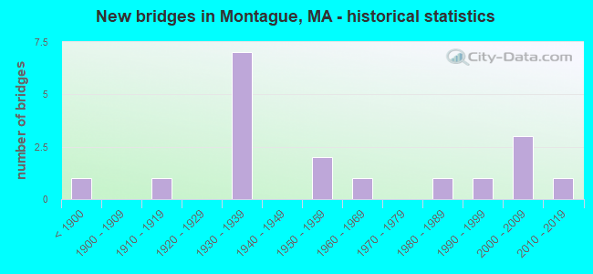
- New bridges - historical statistics
- 1Before 1900
- 11910-1919
- 71930-1939
- 21950-1959
- 11960-1969
- 11980-1989
- 11990-1999
- 32000-2009
- 12010-2019

- Reconstructed bridges - Historical Statistics
- 11970-1979
- 21980-1989
- 21990-1999


- Bridge Condition - Deck
- 5.9%Very good
- 35.3%Good
- 23.5%Satisfactory
- 29.4%Fair
- 5.9%Poor

- Bridge Condition - Superstructure
- 16.7%Very good
- 5.6%Good
- 38.9%Satisfactory
- 16.7%Fair
- 11.1%Poor
- 11.1%Serious

- Bridge Condition - Substructure
- 16.7%Very good
- 16.7%Good
- 38.9%Satisfactory
- 22.2%Fair
- 5.6%Poor

- Bridge Condition - Channel
- 46.2%Good
- 38.5%Satisfactory
- 15.4%Fair
Find on map >> Show street view
Structure Number: M2800614DDOT634, Location: 100' N JCT HIGHLAND AVE. (Lat: 42.573228, Lng: -72.497958), Route carried "on" structure: State highway 63, Year Built: 1935, Year Reconstructed: 1998, Status: Open, Structure Length: 3.62m (11.88ft), Average Daily Traffic: 3,400 (year 2002), Truck Traffic: 9%, Average Future Daily Traffic: 5,370 (year 2031), Design Load: HS 20, Features Intersected: RR BMRR & NECRR
Minimum Vertical Clearance: 30+ m (98+ ft), Kilometerpoint: 20.277, Lanes on structure: 2, Base Highway Network: Yes, Owner: State Highway Agency, Approaching Roadway Width: 12.2m (40.0ft), Skew: 3 degrees, Material/Design: Prestressed concrete, Design/Construction: Box Beam or Girders - Multiple, Number Of Spans In Main Unit: 2, Length of Maximum Span: 19.6m (64.3ft), Curb or Sidewalk Widths: Left: 1.7m (5.6ft), Right: 0.0m, Curb-To-Curb Width: 12.2m (40.0ft), Out-to-Out Width: 14.6m (47.9ft)
Condition: Deck: Satisfactory, Superstructure: Satisfactory, Substructure: Fair, Operating Rating: 69.8 metric tons, Method Used To Determine Operating Rating: Load Factor (LF), Inventory Rating: 41.8 metric tons, Method Used To Determine Inventory Rating: Load Factor (LF), Structural Evaluation: Somewhat better than minimum adequacy, Deck Geometry: Equal to present minimum criteria, Underclear: Somewhat better than minimum adequacy, Approach Roadway Alignment: Better than present minimum criteria, Length Of Structure Improvement: 3.70m (12.14ft), Designated Inspection Frequency: Every 24 months, Inspection Date: July 2020, Bridge Improvement Cost: $2,122,000, Roadway Improvement Cost: $213,000, Total Project Cost: $3,184,000 ( Estimate for 2022), Deck Structure Type: Concrete Precast Panels, Wearing Surface/Protective System: Wearing Surface: Bituminous, Membrane: Preformed Fabric
Find on map >> Show street view
Structure Number: M2800814ADOT634, Location: 100' N JCT SWAMP RD. (Lat: 42.544322, Lng: -72.534394), Route carried "on" structure: City street , Year Built: 1966, Status: Open, Structure Length: 1.51m (4.95ft), Average Daily Traffic: 4,000 (year 2006), Truck Traffic: 6%, Average Future Daily Traffic: 3,677 (year 2031), Design Load: H 20, Features Intersected: RR BMRR, Facility Carried by Structure: HWY TURNERS FLLS
Minimum Vertical Clearance: 30+ m (98+ ft), Kilometerpoint: 0.000, Lanes on structure: 2, Owner: State Highway Agency, Approaching Roadway Width: 7.3m (24.0ft), Material/Design: Prestressed concrete, Design/Construction: Slab, Number Of Spans In Main Unit: 1, Length of Maximum Span: 14.6m (47.9ft), Curb or Sidewalk Widths: Left: 0.3m (1.0ft), Right: 1.5m (4.9ft), Curb-To-Curb Width: 7.3m (24.0ft), Out-to-Out Width: 9.1m (29.9ft)
Condition: Deck: Fair, Superstructure: Fair, Substructure: Good, Operating Rating: 67.4 metric tons, Method Used To Determine Operating Rating: Allowable Stress (AS), Inventory Rating: 29.7 metric tons, Method Used To Determine Inventory Rating: Allowable Stress (AS), Structural Evaluation: Somewhat better than minimum adequacy, Deck Geometry: High priority of replacement, Underclear: High priority of corrective action, Approach Roadway Alignment: Better than present minimum criteria, Length Of Structure Improvement: 1.60m (5.25ft), Designated Inspection Frequency: Every 24 months, Inspection Date: July 2020, Bridge Improvement Cost: $572,000, Roadway Improvement Cost: $58,000, Total Project Cost: $859,000 ( Estimate for 2022), Deck Structure Type: Concrete Precast Panels, Wearing Surface/Protective System: Wearing Surface: Bituminous, Membrane: Built-up
Find on map >> Show street view
Structure Number: M2801512TDOTNBI, Location: 100' E CONN RIVER (Lat: 42.608383, Lng: -72.560528), Route carried "on" structure: City street , Year Built: 1954, Year Reconstructed: 1992, Status: Open, Structure Length: 4.12m (13.52ft), Average Daily Traffic: 14,483 (year 2019), Truck Traffic: 6%, Average Future Daily Traffic: 22,742 (year 2032), Design Load: HS 20, Features Intersected: WATER UTILITY CANAL, Facility Carried by Structure: HWY FIFTH ST
Minimum Vertical Clearance: 30+ m (98+ ft), Kilometerpoint: 87.707, Lanes on structure: 2, Owner: State Highway Agency, Approaching Roadway Width: 7.9m (25.9ft), Material/Design: Steel, Design/Construction: Truss - Thru, Number Of Spans In Main Unit: 1, Length of Maximum Span: 40.7m (133.5ft), Curb or Sidewalk Widths: Left: 0.5m (1.6ft), Right: 0.5m (1.6ft), Curb-To-Curb Width: 7.9m (25.9ft), Out-to-Out Width: 8.7m (28.5ft)
Condition: Deck: Fair, Superstructure: Poor, Substructure: Fair, Channel: Satisfactory, Operating Rating: 43.3 metric tons, Method Used To Determine Operating Rating: Load Factor (LF), Inventory Rating: 26.0 metric tons, Method Used To Determine Inventory Rating: Load Factor (LF), Structural Evaluation: Meets minimum limits, Deck Geometry: High priority of replacement, Waterway Adequacy: Equal to present desirable criteria, Approach Roadway Alignment: Better than present minimum criteria, Length Of Structure Improvement: 5.10m (16.73ft), Designated Inspection Frequency: Every 12 months, Critical Feature Inspection Frequency: Every 24 months, Other Special Inspection Frequency: Every 12 months, Inspection Date: September 2021, Critical Feature Inspection Date: September 2021, Other Special Inspection Date: September 2021, Bridge Improvement Cost: $3,794,000, Roadway Improvement Cost: $380,000, Total Project Cost: $5,692,000 ( Estimate for 2022), Deck Structure Type: Closed Grating, Wearing Surface/Protective System: Wearing Surface: Epoxy Overlay, Deck Protection: Epoxy Coated Reinforcing
Find on map >> Show street view
Structure Number: M280170R4MUNNBI, Location: 250' W INT MONT CTY RD (Lat: 42.602392, Lng: -72.564456), Route carried "on" structure: City street , Year Built: 1915, Year Reconstructed: 1996, Status: Posted for load, Structure Length: 6.14m (20.14ft), Average Daily Traffic: 2,500 (year 2004), Truck Traffic: 2%, Average Future Daily Traffic: 3,948 (year 2031), Design Load: H 15, Features Intersected: WATER UTILITY CANAL, Facility Carried by Structure: HWY ELEVENTH ST
Minimum Vertical Clearance: 30+ m (98+ ft), Kilometerpoint: 0.097, Lanes on structure: 2, Owner: Town or Township Highway Agency, Approaching Roadway Width: 10.7m (35.1ft), Material/Design: Steel, Design/Construction: Truss - Thru, Number Of Spans In Main Unit: 1, Number Of Approach Spans: 2, Length of Maximum Span: 50.8m (166.7ft), Curb or Sidewalk Widths: Left: 1.8m (5.9ft), Right: 1.8m (5.9ft), Curb-To-Curb Width: 7.3m (24.0ft), Out-to-Out Width: 7.9m (25.9ft)
Condition: Deck: Good, Superstructure: Satisfactory, Substructure: Fair, Channel: Good, Operating Rating: 35.9 metric tons, Method Used To Determine Operating Rating: Load Factor (LF), Inventory Rating: 21.5 metric tons, Method Used To Determine Inventory Rating: Load Factor (LF), Structural Evaluation: Somewhat better than minimum adequacy, Deck Geometry: High priority of replacement, Waterway Adequacy: Superior to present desirable criteria, Approach Roadway Alignment: Better than present minimum criteria, Length Of Structure Improvement: 6.20m (20.34ft), Designated Inspection Frequency: Every 24 months, Critical Feature Inspection Frequency: Every 24 months, Inspection Date: September 2020, Critical Feature Inspection Date: September 2020, Bridge Improvement Cost: $1,924,000, Roadway Improvement Cost: $193,000, Total Project Cost: $2,887,000 ( Estimate for 2022), Deck Structure Type: Concrete Cast-file-Place, Wearing Surface/Protective System: Wearing Surface: Latex Concrete, Deck Protection: Epoxy Coated Reinforcing
Find on map >> Show street view
Structure Number: M28018149DOT634, Location: AT JCT S PROSPECT ST. (Lat: 42.576944, Lng: -72.493528), Route carried "on" structure: City street , Year Built: 1897, Year Reconstructed: 1994, Status: Open, Structure Length: 2.95m (9.68ft), Average Daily Traffic: 1,164 (year 2018), Truck Traffic: 6%, Average Future Daily Traffic: 2,042 (year 2031), Design Load: HS 20, Features Intersected: RR BMRR & NECRR, Facility Carried by Structure: HWY BRIDGE ST
Minimum Vertical Clearance: 4.36m (14.30ft), Kilometerpoint: 0.000, Lanes on structure: 2, Owner: State Highway Agency, Approaching Roadway Width: 5.8m (19.0ft), Material/Design: Steel, Design/Construction: Truss - Thru, Number Of Spans In Main Unit: 1, Length of Maximum Span: 29.0m (95.1ft), Curb-To-Curb Width: 5.7m (18.7ft), Out-to-Out Width: 6.3m (20.7ft)
Condition: Deck: Satisfactory, Superstructure: Satisfactory, Substructure: Good, Operating Rating: 51.0 metric tons, Method Used To Determine Operating Rating: Load Factor (LF), Inventory Rating: 30.6 metric tons, Method Used To Determine Inventory Rating: Load Factor (LF), Structural Evaluation: Equal to present minimum criteria, Deck Geometry: High priority of replacement, Underclear: Meets minimum limits, Approach Roadway Alignment: Equal to present minimum criteria, Length Of Structure Improvement: 3.00m (9.84ft), Designated Inspection Frequency: Every 24 months, Critical Feature Inspection Frequency: Every 24 months, Inspection Date: September 2020, Critical Feature Inspection Date: September 2020, Bridge Improvement Cost: $743,000, Roadway Improvement Cost: $75,000, Total Project Cost: $1,115,000 ( Estimate for 2022), Deck Structure Type: Concrete Cast-file-Place, Wearing Surface/Protective System: Wearing Surface: Epoxy Overlay, Deck Protection: Epoxy Coated Reinforcing
Find on map >> Show street view
Structure Number: M28022AGHMUNNBI, Location: 0.1 KM N JCT. MEADOW RD. (Lat: 42.542617, Lng: -72.549219), Route carried "on" structure: City street , Year Built: 2002, Status: Open, Structure Length: 1.92m (6.30ft), Average Daily Traffic: 517 (year 2018), Truck Traffic: 6%, Average Future Daily Traffic: 158 (year 2031), Design Load: HS 20, Features Intersected: WATER SAWMILL RIVER, Facility Carried by Structure: HWY S FERRY RD
Minimum Vertical Clearance: 30+ m (98+ ft), Kilometerpoint: 0.241, Lanes on structure: 2, Owner: Town or Township Highway Agency, Approaching Roadway Width: 6.1m (20.0ft), Skew: 1 degrees, Material/Design: Prestressed concrete, Design/Construction: Box Beam or Girders - Multiple, Number Of Spans In Main Unit: 1, Length of Maximum Span: 18.3m (60.0ft), Curb or Sidewalk Widths: Left: 1.5m (4.9ft), Right: 0.0m, Curb-To-Curb Width: 6.1m (20.0ft), Out-to-Out Width: 8.4m (27.6ft)
Condition: Deck: Good, Superstructure: Very good, Substructure: Very good, Channel: Good, Operating Rating: 62.2 metric tons, Method Used To Determine Operating Rating: Load Factor (LF), Inventory Rating: 34.1 metric tons, Method Used To Determine Inventory Rating: Load Factor (LF), Structural Evaluation: Equal to present desirable criteria, Deck Geometry: High priority of corrective action, Waterway Adequacy: Superior to present desirable criteria, Approach Roadway Alignment: Equal to present desirable criteria, Length Of Structure Improvement: 2.00m (6.56ft), Designated Inspection Frequency: Every 24 months, Inspection Date: May 2020, Bridge Improvement Cost: $1,151,000, Roadway Improvement Cost: $116,000, Total Project Cost: $1,727,000 ( Estimate for 2022), Deck Structure Type: Concrete Cast-file-Place, Wearing Surface/Protective System: Wearing Surface: Bituminous, Membrane: Preformed Fabric, Deck Protection: Epoxy Coated Reinforcing
Find on map >> Show street view
Structure Number: M28023AGJMUNNBI, Location: 200' W OF GREENFIELD RD (Lat: 42.539139, Lng: -72.539417), Route carried "on" structure: City street , Year Built: 2002, Status: Open, Structure Length: 2.45m (8.04ft), Average Daily Traffic: 388 (year 2019), Truck Traffic: 1%, Average Future Daily Traffic: 816 (year 2032), Design Load: HS 20, Features Intersected: WATER SAWMILL RIVER, Facility Carried by Structure: HWY MEADOW RD
Minimum Vertical Clearance: 30+ m (98+ ft), Kilometerpoint: 5.182, Lanes on structure: 2, Owner: Town or Township Highway Agency, Approaching Roadway Width: 6.0m (19.7ft), Material/Design: Steel, Design/Construction: Stringer/Multi-beam, Number Of Spans In Main Unit: 1, Length of Maximum Span: 22.7m (74.5ft), Curb or Sidewalk Widths: Left: 0.0m, Right: 1.5m (4.9ft), Curb-To-Curb Width: 6.1m (20.0ft), Out-to-Out Width: 8.4m (27.6ft)
Condition: Deck: Good, Superstructure: Satisfactory, Substructure: Good, Channel: Good, Operating Rating: 60.3 metric tons, Method Used To Determine Operating Rating: Load Factor (LF), Inventory Rating: 36.0 metric tons, Method Used To Determine Inventory Rating: Load Factor (LF), Structural Evaluation: Equal to present minimum criteria, Deck Geometry: Meets minimum limits, Waterway Adequacy: Equal to present desirable criteria, Approach Roadway Alignment: Equal to present minimum criteria, Length Of Structure Improvement: 2.50m (8.20ft), Designated Inspection Frequency: Every 24 months, Inspection Date: December 2021, Bridge Improvement Cost: $1,155,000, Roadway Improvement Cost: $116,000, Total Project Cost: $1,733,000 ( Estimate for 2022), Deck Structure Type: Concrete Cast-file-Place, Wearing Surface/Protective System: Wearing Surface: Latex Concrete, Deck Protection: Epoxy Coated Reinforcing
Find on map >> Show street view
Structure Number: M280240MBMUNNBI, Location: AT JCT OF GFLD RD (Lat: 42.537542, Lng: -72.536389), Route carried "on" structure: City street , Year Built: 1990, Status: Open, Structure Length: 3.29m (10.79ft), Average Daily Traffic: 5,043 (year 2017), Truck Traffic: 5%, Average Future Daily Traffic: 5,719 (year 2032), Design Load: HS 20, Features Intersected: WATER SAWMILL RIVER, Facility Carried by Structure: HWY MAIN ST
Minimum Vertical Clearance: 30+ m (98+ ft), Kilometerpoint: 0.274, Lanes on structure: 2, Owner: Town or Township Highway Agency, Approaching Roadway Width: 9.8m (32.2ft), Skew: 2 degrees, Material/Design: Prestressed concrete, Design/Construction: Stringer/Multi-beam, Number Of Spans In Main Unit: 1, Length of Maximum Span: 32.0m (105.0ft), Curb or Sidewalk Widths: Left: 0.2m (0.7ft), Right: 1.5m (4.9ft), Curb-To-Curb Width: 9.8m (32.2ft), Out-to-Out Width: 12.3m (40.4ft)
Condition: Deck: Good, Superstructure: Satisfactory, Substructure: Satisfactory, Channel: Good, Operating Rating: 65.1 metric tons, Method Used To Determine Operating Rating: Load Factor (LF), Inventory Rating: 34.7 metric tons, Method Used To Determine Inventory Rating: Load Factor (LF), Structural Evaluation: Equal to present minimum criteria, Deck Geometry: Meets minimum limits, Waterway Adequacy: Superior to present desirable criteria, Approach Roadway Alignment: Equal to present minimum criteria, Length Of Structure Improvement: 3.30m (10.83ft), Designated Inspection Frequency: Every 24 months, Inspection Date: November 2021, Bridge Improvement Cost: $1,121,000, Roadway Improvement Cost: $113,000, Total Project Cost: $1,682,000 ( Estimate for 2022), Deck Structure Type: Concrete Cast-file-Place, Wearing Surface/Protective System: Wearing Surface: Bituminous, Membrane: Built-up, Deck Protection: Epoxy Coated Reinforcing
Find on map >> Show street view
Structure Number: M280250MCMUNNBI, Location: 0.2 MI W OF ST 63 (Lat: 42.535669, Lng: -72.526331), Route carried "on" structure: City street , Year Built: 1937, Status: Posted for load, Structure Length: 1.06m (3.48ft), Average Daily Traffic: 517 (year 2019), Truck Traffic: 5%, Average Future Daily Traffic: 948 (year 2031), Features Intersected: WATER SAWMILL RIVER, Facility Carried by Structure: HWY CENTER ST
Minimum Vertical Clearance: 30+ m (98+ ft), Kilometerpoint: 0.644, Lanes on structure: 2, Owner: Town or Township Highway Agency, Approaching Roadway Width: 7.3m (24.0ft), Material/Design: Steel, Design/Construction: Stringer/Multi-beam, Number Of Spans In Main Unit: 1, Length of Maximum Span: 9.6m (31.5ft), Curb or Sidewalk Widths: Left: 1.8m (5.9ft), Right: 0.2m (0.7ft), Curb-To-Curb Width: 7.3m (24.0ft), Out-to-Out Width: 10.0m (32.8ft)
Condition: Deck: Fair, Superstructure: Serious, Substructure: Satisfactory, Channel: Satisfactory, Operating Rating: 1.2 metric tons, Method Used To Determine Operating Rating: Load Factor (LF), Inventory Rating: 0.7 metric tons, Method Used To Determine Inventory Rating: Load Factor (LF), Structural Evaluation: High priority of replacement, Deck Geometry: Meets minimum limits, Waterway Adequacy: Somewhat better than minimum adequacy, Approach Roadway Alignment: Meets minimum limits, Bridge Posting: Required (Relationship of Operating Rating to Maximum Legal Load: > 39.9% below), Length Of Structure Improvement: 1.80m (5.91ft), Designated Inspection Frequency: Every 6 months, Underwater Inspection Frequency: Every 36 months, Other Special Inspection Frequency: Every 6 months, Inspection Date: October 2020, Underwater Inspection Date: Febuary 2020, Other Special Inspection Date: October 2021, Bridge Improvement Cost: $1,405,000, Roadway Improvement Cost: $141,000, Total Project Cost: $2,108,000 ( Estimate for 2022), Deck Structure Type: Concrete Cast-file-Place, Wearing Surface/Protective System: Wearing Surface: Bituminous
Find on map >> Show street view
Structure Number: M280260R6MUNNBI, Location: 0.2 MI W OF ST 63 (Lat: 42.530919, Lng: -72.529336), Route carried "on" structure: City street , Year Built: 1938, Status: Temporarily open, Structure Length: 1.36m (4.46ft), Average Daily Traffic: 647 (year 2019), Truck Traffic: 6%, Average Future Daily Traffic: 1,027 (year 2032), Design Load: H 15, Features Intersected: WATER SAWMILL RIVER, Facility Carried by Structure: HWY SOUTH ST
Minimum Vertical Clearance: 30+ m (98+ ft), Kilometerpoint: 0.225, Lanes on structure: 2, Owner: Town or Township Highway Agency, Approaching Roadway Width: 6.4m (21.0ft), Skew: 1 degrees, Material/Design: Steel, Design/Construction: Stringer/Multi-beam, Number Of Spans In Main Unit: 1, Length of Maximum Span: 12.8m (42.0ft), Curb or Sidewalk Widths: Left: 0.2m (0.7ft), Right: 0.2m (0.7ft), Curb-To-Curb Width: 6.1m (20.0ft), Out-to-Out Width: 7.3m (24.0ft)
Condition: Deck: Satisfactory, Superstructure: Poor, Substructure: Satisfactory, Channel: Fair, Structural Evaluation: High priority of replacement, Deck Geometry: High priority of corrective action, Waterway Adequacy: Meets minimum limits, Approach Roadway Alignment: Equal to present desirable criteria, Bridge Posting: Required (Relationship of Operating Rating to Maximum Legal Load: > 39.9% below), Length Of Structure Improvement: 2.10m (6.89ft), Designated Inspection Frequency: Every 12 months, Underwater Inspection Frequency: Every 36 months, Other Special Inspection Frequency: Every 12 months, Inspection Date: October 2021, Underwater Inspection Date: Febuary 2020, Other Special Inspection Date: October 2021, Bridge Improvement Cost: $1,474,000, Roadway Improvement Cost: $148,000, Total Project Cost: $2,212,000 ( Estimate for 2022), Deck Structure Type: Concrete Cast-file-Place, Wearing Surface/Protective System: Wearing Surface: Bituminous
Find on map >> Show street view
Structure Number: M28028AQ9MUNNBI, Location: AT E. END 6TH ST. (Lat: 42.605481, Lng: -72.554931), Route carried "on" structure: City street , Year Built: 2010, Status: Open, Structure Length: 2.63m (8.63ft), Average Daily Traffic: 400 (year 1997), Average Future Daily Traffic: 632 (year 2031), Design Load: HS 25 or greater, Features Intersected: HWY SPRING ST, Facility Carried by Structure: HWY PROSPECT ST
Minimum Vertical Clearance: 30+ m (98+ ft), Kilometerpoint: 0.225, Lanes on structure: 2, Lanes under structure: 2, Owner: Town or Township Highway Agency, Approaching Roadway Width: 7.3m (24.0ft), Material/Design: Prestressed concrete, Design/Construction: Box Beam or Girders - Single/Spread, Number Of Spans In Main Unit: 1, Length of Maximum Span: 25.0m (82.0ft), Curb or Sidewalk Widths: Left: 0.0m, Right: 1.8m (5.9ft), Curb-To-Curb Width: 7.3m (24.0ft), Out-to-Out Width: 9.9m (32.5ft)
Condition: Deck: Very good, Superstructure: Very good, Substructure: Very good, Operating Rating: 83.5 metric tons, Method Used To Determine Operating Rating: Load Factor (LF), Inventory Rating: 61.7 metric tons, Method Used To Determine Inventory Rating: Load Factor (LF), Structural Evaluation: Equal to present desirable criteria, Deck Geometry: Somewhat better than minimum adequacy, Underclear: Superior to present desirable criteria, Approach Roadway Alignment: Equal to present desirable criteria, Length Of Structure Improvement: 2.70m (8.86ft), Designated Inspection Frequency: Every 24 months, Inspection Date: October 2020, Bridge Improvement Cost: $937,000, Roadway Improvement Cost: $94,000, Total Project Cost: $1,406,000 ( Estimate for 2022), Deck Structure Type: Concrete Cast-file-Place, Wearing Surface/Protective System: Wearing Surface: Bituminous, Membrane: Preformed Fabric, Deck Protection: Epoxy Coated Reinforcing
Find on map >> Show street view
Structure Number: M2803214BDOT634, Location: AT SUNDERLAND T.L. (Lat: 42.509931, Lng: -72.527131), Route carried "on" structure: State highway 63, Year Built: 1938, Status: Open, Structure Length: 3.96m (12.99ft), Average Daily Traffic: 4,525 (year 2018), Truck Traffic: 2%, Average Future Daily Traffic: 4,901 (year 2032), Design Load: H 20, Features Intersected: RR NECRR
Minimum Vertical Clearance: 30+ m (98+ ft), Kilometerpoint: 12.524, Lanes on structure: 2, Base Highway Network: Yes, Owner: State Highway Agency, Approaching Roadway Width: 12.2m (40.0ft), Skew: 3 degrees, Material/Design: Steel continuous, Design/Construction: Stringer/Multi-beam, Number Of Spans In Main Unit: 3, Length of Maximum Span: 14.2m (46.6ft), Curb or Sidewalk Widths: Left: 0.2m (0.7ft), Right: 1.4m (4.6ft), Curb-To-Curb Width: 12.2m (40.0ft), Out-to-Out Width: 15.3m (50.2ft)
Condition: Deck: Poor, Superstructure: Fair, Substructure: Satisfactory, Operating Rating: 57.4 metric tons, Method Used To Determine Operating Rating: Load Factor (LF), Inventory Rating: 34.4 metric tons, Method Used To Determine Inventory Rating: Load Factor (LF), Structural Evaluation: Somewhat better than minimum adequacy, Deck Geometry: Equal to present minimum criteria, Underclear: High priority of corrective action, Approach Roadway Alignment: Better than present minimum criteria, Length Of Structure Improvement: 4.00m (13.12ft), Designated Inspection Frequency: Every 12 months, Other Special Inspection Frequency: Every 12 months, Inspection Date: September 2021, Other Special Inspection Date: September 2021, Bridge Improvement Cost: $2,404,000, Roadway Improvement Cost: $241,000, Total Project Cost: $3,607,000 ( Estimate for 2022), Deck Structure Type: Concrete Cast-file-Place, Wearing Surface/Protective System: Wearing Surface: Monolithic Concrete, Membrane: Other
Find on map >> Show street view
Structure Number: M280330W4DOTNBI, Location: JCT. ST 47 (Lat: 42.518503, Lng: -72.528217), Route carried "on" structure: State highway 63, Year Built: 1935, Status: Open, Structure Length: 1.04m (3.41ft), Average Daily Traffic: 4,655 (year 2018), Truck Traffic: 9%, Average Future Daily Traffic: 5,370 (year 2031), Design Load: H 20, Features Intersected: WATER SAWMILL RIVER
Minimum Vertical Clearance: 30+ m (98+ ft), Kilometerpoint: 13.518, Lanes on structure: 2, Base Highway Network: Yes, Owner: State Highway Agency, Approaching Roadway Width: 12.2m (40.0ft), Skew: 2 degrees, Material/Design: Concrete, Design/Construction: Tee Beam, Number Of Spans In Main Unit: 1, Length of Maximum Span: 8.5m (27.9ft), Curb or Sidewalk Widths: Left: 0.2m (0.7ft), Right: 1.5m (4.9ft), Curb-To-Curb Width: 12.2m (40.0ft), Out-to-Out Width: 14.6m (47.9ft)
Condition: Deck: Satisfactory, Superstructure: Fair, Substructure: Fair, Channel: Fair, Operating Rating: 80.6 metric tons, Method Used To Determine Operating Rating: Load Factor (LF), Inventory Rating: 48.3 metric tons, Method Used To Determine Inventory Rating: Load Factor (LF), Structural Evaluation: Somewhat better than minimum adequacy, Deck Geometry: Equal to present minimum criteria, Waterway Adequacy: Equal to present desirable criteria, Approach Roadway Alignment: Equal to present desirable criteria, Length Of Structure Improvement: 1.10m (3.61ft), Designated Inspection Frequency: Every 24 months, Inspection Date: October 2020, Bridge Improvement Cost: $631,000, Roadway Improvement Cost: $64,000, Total Project Cost: $947,000 ( Estimate for 2022), Deck Structure Type: Concrete Cast-file-Place, Wearing Surface/Protective System: Wearing Surface: Bituminous, Membrane: Built-up
Find on map >> Show street view
Structure Number: M280340MDMUNNBI, Location: 0.2 MI E OF SPLDNG BRK RD (Lat: 42.512881, Lng: -72.503644), Route carried "on" structure: City street , Year Built: 1939, Status: Posted for load, Structure Length: 1.37m (4.49ft), Average Daily Traffic: 2,844 (year 2019), Truck Traffic: 10%, Average Future Daily Traffic: 1,429 (year 2032), Design Load: H 20, Features Intersected: WATER SAWMILL RIVER, Facility Carried by Structure: HWY N LEVERET RD
Minimum Vertical Clearance: 30+ m (98+ ft), Kilometerpoint: 2.253, Lanes on structure: 2, Owner: Town or Township Highway Agency, Approaching Roadway Width: 7.3m (24.0ft), Material/Design: Steel, Design/Construction: Stringer/Multi-beam, Number Of Spans In Main Unit: 1, Length of Maximum Span: 12.8m (42.0ft), Curb or Sidewalk Widths: Left: 0.2m (0.7ft), Right: 0.2m (0.7ft), Curb-To-Curb Width: 7.3m (24.0ft), Out-to-Out Width: 8.5m (27.9ft)
Condition: Deck: Fair, Superstructure: Serious, Substructure: Poor, Channel: Satisfactory, Operating Rating: 45.4 metric tons, Method Used To Determine Operating Rating: Load Factor (LF), Inventory Rating: 27.2 metric tons, Method Used To Determine Inventory Rating: Load Factor (LF), Structural Evaluation: High priority of corrective action, Deck Geometry: High priority of replacement, Waterway Adequacy: Equal to present desirable criteria, Approach Roadway Alignment: Better than present minimum criteria, Bridge Posting: Required (Relationship of Operating Rating to Maximum Legal Load: 20.0 - 29.9% below), Length Of Structure Improvement: 2.10m (6.89ft), Designated Inspection Frequency: Every 6 months, Other Special Inspection Frequency: Every 6 months, Inspection Date: March 2021, Other Special Inspection Date: September 2021, Bridge Improvement Cost: $1,606,000, Roadway Improvement Cost: $161,000, Total Project Cost: $2,410,000 ( Estimate for 2022), Deck Structure Type: Concrete Cast-file-Place, Wearing Surface/Protective System: Wearing Surface: Bituminous
Find on map >> Show street view
Structure Number: M28035AP9MUNNBI, Location: AT WENDELL TOWN LINE (Lat: 42.571203, Lng: -72.464278), Route carried "on" structure: City street , Year Built: 2004, Status: Open, Structure Length: 1.45m (4.76ft), Average Daily Traffic: 60 (year 2012), Truck Traffic: 10%, Average Future Daily Traffic: 95 (year 2031), Design Load: HS 20, Features Intersected: WATER LYONS BROOK, Facility Carried by Structure: HWY DAVIS RD
Minimum Vertical Clearance: 30+ m (98+ ft), Kilometerpoint: 1.127, Lanes on structure: 2, Owner: Town or Township Highway Agency, Approaching Roadway Width: 7.3m (24.0ft), Skew: 4 degrees, Material/Design: Steel, Design/Construction: Stringer/Multi-beam, Number Of Spans In Main Unit: 1, Length of Maximum Span: 12.8m (42.0ft), Curb-To-Curb Width: 7.3m (24.0ft), Out-to-Out Width: 8.2m (26.9ft)
Condition: Deck: Good, Superstructure: Very good, Substructure: Very good, Channel: Good, Operating Rating: 75.5 metric tons, Method Used To Determine Operating Rating: Load Factor (LF), Inventory Rating: 45.2 metric tons, Method Used To Determine Inventory Rating: Load Factor (LF), Structural Evaluation: Equal to present desirable criteria, Deck Geometry: Equal to present minimum criteria, Waterway Adequacy: Equal to present desirable criteria, Approach Roadway Alignment: Superior to present desirable criteria, Length Of Structure Improvement: 1.50m (4.92ft), Designated Inspection Frequency: Every 24 months, Inspection Date: May 2020, Bridge Improvement Cost: $352,000, Roadway Improvement Cost: $36,000, Total Project Cost: $529,000 ( Estimate for 2022), Deck Structure Type: Concrete Cast-file-Place, Wearing Surface/Protective System: Wearing Surface: Bituminous, Membrane: Preformed Fabric, Deck Protection: Epoxy Coated Reinforcing
Find on map >> Show street view
Structure Number: M280400R9MUNNBI, Location: 1M E OF RT63 NR LEVERETT (Lat: 42.514694, Lng: -72.506028), Route carried "on" structure: City street , Year Built: 1937, Year Reconstructed: 1983, Status: Open, Structure Length: 0.85m (2.79ft), Average Daily Traffic: 100 (year 2019), Truck Traffic: 6%, Average Future Daily Traffic: 158 (year 2032), Design Load: H 20, Features Intersected: WATER SAWMILL RIVER, Facility Carried by Structure: HWY SPLDNG BK RD
Minimum Vertical Clearance: 30+ m (98+ ft), Kilometerpoint: 0.161, Lanes on structure: 1, Owner: Town or Township Highway Agency, Approaching Roadway Width: 5.0m (16.4ft), Skew: 1 degrees, Material/Design: Prestressed concrete, Design/Construction: Slab, Number Of Spans In Main Unit: 1, Length of Maximum Span: 8.1m (26.6ft), Curb or Sidewalk Widths: Left: 0.2m (0.7ft), Right: 0.2m (0.7ft), Curb-To-Curb Width: 3.7m (12.1ft), Out-to-Out Width: 4.9m (16.1ft)
Condition: Deck: Good, Superstructure: Good, Substructure: Satisfactory, Channel: Satisfactory, Operating Rating: 65.3 metric tons, Method Used To Determine Operating Rating: Load Factor (LF), Inventory Rating: 39.1 metric tons, Method Used To Determine Inventory Rating: Load Factor (LF), Structural Evaluation: Equal to present minimum criteria, Deck Geometry: Meets minimum limits, Waterway Adequacy: Equal to present minimum criteria, Approach Roadway Alignment: Somewhat better than minimum adequacy, Length Of Structure Improvement: 1.60m (5.25ft), Designated Inspection Frequency: Every 24 months, Underwater Inspection Frequency: Every 34 months, Inspection Date: July 2021, Underwater Inspection Date: May 2020, Bridge Improvement Cost: $512,000, Roadway Improvement Cost: $52,000, Total Project Cost: $769,000 ( Estimate for 2022), Deck Structure Type: Concrete Precast Panels, Wearing Surface/Protective System: Wearing Surface: Bituminous
Find on map >> Show street view
Structure Number: M280410R8MUNNBI, Location: AT WENDELL TOWN LINE (Lat: 42.572267, Lng: -72.463808), Route carried "on" structure: City street , Year Built: 1951, Status: Open, Structure Length: 0.74m (2.43ft), Average Daily Traffic: 259 (year 2019), Truck Traffic: 5%, Average Future Daily Traffic: 948 (year 2032), Features Intersected: WATER LYONS BROOK, Facility Carried by Structure: HWY MORMN HLW RD
Minimum Vertical Clearance: 30+ m (98+ ft), Kilometerpoint: 1.127, Lanes on structure: 2, Owner: Town or Township Highway Agency, Approaching Roadway Width: 7.0m (23.0ft), Skew: 3 degrees, Material/Design: Steel, Design/Construction: Arch - Deck, Number Of Spans In Main Unit: 1, Length of Maximum Span: 7.4m (24.3ft), Curb-To-Curb Width: 7.0m (23.0ft), Out-to-Out Width: 7.0m (23.0ft)
Condition: Superstructure: Satisfactory, Substructure: Satisfactory, Channel: Satisfactory, Operating Rating: 40.5 metric tons, Method Used To Determine Operating Rating: Allowable Stress (AS), Inventory Rating: 32.4 metric tons, Method Used To Determine Inventory Rating: Allowable Stress (AS), Structural Evaluation: Equal to present minimum criteria, Deck Geometry: Meets minimum limits, Waterway Adequacy: Better than present minimum criteria, Approach Roadway Alignment: Better than present minimum criteria, Length Of Structure Improvement: 0.80m (2.62ft), Designated Inspection Frequency: Every 24 months, Inspection Date: July 2021, Bridge Improvement Cost: $302,000, Roadway Improvement Cost: $31,000, Total Project Cost: $454,000 ( Estimate for 2022)
Find on map >> Show street view
Structure Number: M2816A0R2MUNNBI, Location: JCT 6TH ST & UTIL CANAL (Lat: 42.607489, Lng: -72.561372), Route carried "on" structure: City street , Year Built: 1988, Status: Posted for load, Structure Length: 5.11m (16.77ft), Average Daily Traffic: 517 (year 2017), Truck Traffic: 6%, Average Future Daily Traffic: 316 (year 2032), Design Load: HS 20, Features Intersected: WATER UTILITY CANAL, Facility Carried by Structure: HWY SIXTH ST
Minimum Vertical Clearance: 30+ m (98+ ft), Kilometerpoint: 0.032, Lanes on structure: 1, Owner: Town or Township Highway Agency, Approaching Roadway Width: 4.3m (14.1ft), Material/Design: Steel, Design/Construction: Truss - Thru, Number Of Spans In Main Unit: 1, Length of Maximum Span: 48.8m (160.1ft), Curb-To-Curb Width: 4.1m (13.5ft), Out-to-Out Width: 5.0m (16.4ft)
Condition: Deck: Fair, Superstructure: Satisfactory, Substructure: Satisfactory, Channel: Good, Operating Rating: 41.9 metric tons, Method Used To Determine Operating Rating: Load Factor (LF), Inventory Rating: 25.1 metric tons, Method Used To Determine Inventory Rating: Load Factor (LF), Structural Evaluation: Equal to present minimum criteria, Deck Geometry: High priority of replacement, Waterway Adequacy: Equal to present desirable criteria, Approach Roadway Alignment: High priority of corrective action, Length Of Structure Improvement: 5.20m (17.06ft), Designated Inspection Frequency: Every 24 months, Critical Feature Inspection Frequency: Every 24 months, Inspection Date: September 2021, Critical Feature Inspection Date: September 2021, Bridge Improvement Cost: $1,022,000, Roadway Improvement Cost: $103,000, Total Project Cost: $1,534,000 ( Estimate for 2022), Deck Structure Type: Steel plate, Wearing Surface/Protective System: Wearing Surface: Other