Bridge Statistics for Mims, Florida (FL)
Condition, Traffic, Stress, Structural Evaluation, Project Costs
- National Bridge Inventory (NBI) Statistics
- 14Number of bridges
- 148ft / 44.6mTotal length
- 203,508Total average daily traffic
- 41,144Total average daily truck traffic
- National Bridge Inventory (NBI) Registered Bridges for Mims
- No street view available for this location
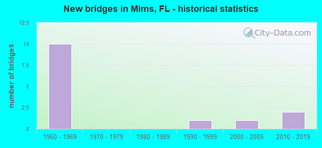
- New bridges - historical statistics
- 101960-1969
- 11990-1999
- 12000-2009
- 22010-2019

- Reconstructed bridges - Historical Statistics
- 11980-1989
- 11990-1999
- 22000-2009


- Bridge Condition - Deck
- 16.7%Very good
- 83.3%Good

- Bridge Condition - Superstructure
- 16.7%Very good
- 83.3%Good

- Bridge Condition - Substructure
- 16.7%Very good
- 83.3%Good

- Bridge Condition - Channel
- 25.0%Very good
- 75.0%Good

- Bridge Condition - Culverts
- 33.3%Good
- 66.7%Satisfactory
Find on map >> Show street view
Structure Number: 700064, Location: 0.8 Mi North of SR-46 (Lat: 28.679444, Lng: -80.875278), Route carried "on" structure: Interstate 95, Year Built: 1967, Status: Open, Structure Length: 0.77m (2.53ft), Average Daily Traffic: 31,492 (year 2020), Truck Traffic: 23%, Average Future Daily Traffic: 54,639 (year 2042), Design Load: HS 20, Features Intersected: Outfall
Minimum Vertical Clearance: 30+ m (98+ ft), Kilometerpoint: 37.337, Lanes on structure: 6, Base Highway Network: Yes, Owner: State Highway Agency, Approaching Roadway Width: 24.1m (79.1ft), Skew: 30 degrees, Material/Design: Concrete, Design/Construction: Culvert, Number Of Spans In Main Unit: 3, Length of Maximum Span: 2.4m (7.9ft)
Condition: Channel: Good, Culverts: Good, Operating Rating: 73.3 metric tons, Method Used To Determine Operating Rating: Load Factor (LF), Inventory Rating: 43.9 metric tons, Method Used To Determine Inventory Rating: Load Factor (LF), Structural Evaluation: Better than present minimum criteria, Waterway Adequacy: Equal to present desirable criteria, Approach Roadway Alignment: Equal to present desirable criteria, Designated Inspection Frequency: Every 24 months, Underwater Inspection Frequency: Every 24 months, Inspection Date: December 2020, Underwater Inspection Date: December 2020
Find on map >> Show street view
Structure Number: 700065, Location: 2.3 MI N of SR-46 (Lat: 28.697972, Lng: -80.882775), Route carried "on" structure: Interstate 95, Year Built: 1967, Status: Open, Structure Length: 0.78m (2.56ft), Average Daily Traffic: 31,492 (year 2020), Truck Traffic: 23%, Average Future Daily Traffic: 54,639 (year 2042), Design Load: HS 20, Features Intersected: Outfall
Minimum Vertical Clearance: 30+ m (98+ ft), Kilometerpoint: 39.521, Lanes on structure: 6, Base Highway Network: Yes, Owner: State Highway Agency, Approaching Roadway Width: 24.4m (80.1ft), Skew: 30 degrees, Material/Design: Concrete, Design/Construction: Culvert, Number Of Spans In Main Unit: 3, Length of Maximum Span: 2.4m (7.9ft)
Condition: Channel: Good, Culverts: Satisfactory, Operating Rating: 74.2 metric tons, Method Used To Determine Operating Rating: Load Factor (LF), Inventory Rating: 44.5 metric tons, Method Used To Determine Inventory Rating: Load Factor (LF), Structural Evaluation: Equal to present minimum criteria, Waterway Adequacy: Equal to present desirable criteria, Approach Roadway Alignment: Equal to present desirable criteria, Designated Inspection Frequency: Every 24 months, Underwater Inspection Frequency: Every 24 months, Inspection Date: December 2020, Underwater Inspection Date: December 2020
Find on map >> Show street view
Structure Number: 700066, Location: 4.5 Mi. N of SR-46 (Lat: 28.728056, Lng: -80.887956), Route carried "on" structure: Interstate 95, Year Built: 1967, Year Reconstructed: 2014, Status: Open, Structure Length: 10.18m (33.40ft), Average Daily Traffic: 15,746 (year 2020), Truck Traffic: 23%, Average Future Daily Traffic: 27,319 (year 2042), Design Load: HL 93, Features Intersected: Aurantia Rd.
Minimum Vertical Clearance: 30+ m (98+ ft), Kilometerpoint: 42.929, Lanes on structure: 3, Lanes under structure: 2, Base Highway Network: Yes, Owner: State Highway Agency, Approaching Roadway Width: 17.3m (56.8ft), Skew: 3 degrees, Material/Design: Prestressed concrete, Design/Construction: Stringer/Multi-beam, Number Of Spans In Main Unit: 5, Length of Maximum Span: 24.4m (80.1ft), Curb-To-Curb Width: 17.3m (56.8ft), Out-to-Out Width: 18.2m (59.7ft)
Condition: Deck: Good, Superstructure: Good, Substructure: Good, Operating Rating: 42.5 metric tons, Method Used To Determine Operating Rating: Load and Resistance Factor (LRFR), Inventory Rating: 35.9 metric tons, Method Used To Determine Inventory Rating: Load and Resistance Factor (LRFR), Structural Evaluation: Better than present minimum criteria, Deck Geometry: Better than present minimum criteria, Underclear: Meets minimum limits, Approach Roadway Alignment: Equal to present desirable criteria, Designated Inspection Frequency: Every 24 months, Inspection Date: December 2020, Deck Structure Type: Concrete Cast-file-Place
Find on map >> Show street view
Structure Number: 700102, Location: I-95 SB - CR-5A (Lat: 28.771217, Lng: -80.894078), Route carried "on" structure: Interstate 95, Year Built: 1969, Year Reconstructed: 1996, Status: Open, Structure Length: 6.68m (21.92ft), Average Daily Traffic: 15,746 (year 2020), Truck Traffic: 23%, Average Future Daily Traffic: 27,319 (year 2042), Design Load: HS 20, Features Intersected: CR-5A
Minimum Vertical Clearance: 30+ m (98+ ft), Kilometerpoint: 47.910, Lanes on structure: 2, Lanes under structure: 2, Base Highway Network: Yes, Owner: State Highway Agency, Approaching Roadway Width: 17.1m (56.1ft), Skew: 2 degrees, Material/Design: Prestressed concrete, Design/Construction: Stringer/Multi-beam, Number Of Spans In Main Unit: 4, Length of Maximum Span: 21.1m (69.2ft), Curb-To-Curb Width: 17.1m (56.1ft), Out-to-Out Width: 18.0m (59.1ft)
Condition: Deck: Good, Superstructure: Good, Substructure: Good, Operating Rating: 58.4 metric tons, Method Used To Determine Operating Rating: Load Factor (LF), Inventory Rating: 34.9 metric tons, Method Used To Determine Inventory Rating: Load Factor (LF), Structural Evaluation: Better than present minimum criteria, Deck Geometry: Superior to present desirable criteria, Underclear: Equal to present minimum criteria, Approach Roadway Alignment: Equal to present desirable criteria, Designated Inspection Frequency: Every 24 months, Inspection Date: Febuary 2021, Deck Structure Type: Concrete Cast-file-Place
Find on map >> Show street view
Structure Number: 700138, Location: 4.5 Mi. N of SR-46 (Lat: 28.727797, Lng: -80.887686), Route carried "on" structure: Interstate 95, Year Built: 1967, Year Reconstructed: 1994, Status: Open, Structure Length: 10.18m (33.40ft), Average Daily Traffic: 15,746 (year 2020), Truck Traffic: 23%, Average Future Daily Traffic: 27,319 (year 2042), Design Load: HL 93, Features Intersected: Aurantia Rd.
Minimum Vertical Clearance: 30+ m (98+ ft), Kilometerpoint: 42.929, Lanes on structure: 3, Lanes under structure: 2, Base Highway Network: Yes, Owner: State Highway Agency, Approaching Roadway Width: 17.1m (56.1ft), Skew: 9 degrees, Material/Design: Prestressed concrete, Design/Construction: Stringer/Multi-beam, Number Of Spans In Main Unit: 5, Length of Maximum Span: 37.3m (122.4ft), Curb-To-Curb Width: 17.1m (56.1ft), Out-to-Out Width: 18.0m (59.1ft)
Condition: Deck: Good, Superstructure: Good, Substructure: Good, Operating Rating: 42.5 metric tons, Method Used To Determine Operating Rating: Load and Resistance Factor (LRFR), Inventory Rating: 35.9 metric tons, Method Used To Determine Inventory Rating: Load and Resistance Factor (LRFR), Structural Evaluation: Better than present minimum criteria, Deck Geometry: Equal to present minimum criteria, Underclear: Somewhat better than minimum adequacy, Approach Roadway Alignment: Equal to present desirable criteria, Designated Inspection Frequency: Every 24 months, Inspection Date: December 2020, Deck Structure Type: Concrete Cast-file-Place
Find on map >> Show street view
Structure Number: 700156, Location: I-95 NB - CR-5A (Lat: 28.771392, Lng: -80.893828), Route carried "on" structure: Interstate 95, Year Built: 1969, Year Reconstructed: 2014, Status: Open, Structure Length: 6.68m (21.92ft), Average Daily Traffic: 15,746 (year 2020), Truck Traffic: 23%, Average Future Daily Traffic: 27,319 (year 2042), Design Load: HS 20, Features Intersected: CR-5A
Minimum Vertical Clearance: 30+ m (98+ ft), Kilometerpoint: 47.910, Lanes on structure: 2, Lanes under structure: 2, Base Highway Network: Yes, Owner: State Highway Agency, Approaching Roadway Width: 17.1m (56.1ft), Skew: 2 degrees, Material/Design: Prestressed concrete, Design/Construction: Stringer/Multi-beam, Number Of Spans In Main Unit: 4, Length of Maximum Span: 21.1m (69.2ft), Curb-To-Curb Width: 17.1m (56.1ft), Out-to-Out Width: 18.0m (59.1ft)
Condition: Deck: Good, Superstructure: Good, Substructure: Good, Operating Rating: 58.4 metric tons, Method Used To Determine Operating Rating: Load Factor (LF), Inventory Rating: 34.9 metric tons, Method Used To Determine Inventory Rating: Load Factor (LF), Structural Evaluation: Better than present minimum criteria, Deck Geometry: Superior to present desirable criteria, Underclear: Equal to present minimum criteria, Approach Roadway Alignment: Equal to present desirable criteria, Designated Inspection Frequency: Every 24 months, Inspection Date: Febuary 2021, Deck Structure Type: Concrete Cast-file-Place
Find on map >> Show street view
Structure Number: 700194, Location: SR-46 over Six Mile Cr (Lat: 28.665611, Lng: -80.910050), Route carried "on" structure: State highway 46, Year Built: 1999, Status: Open, Structure Length: 3.26m (10.70ft), Average Daily Traffic: 7,900 (year 2020), Truck Traffic: 16%, Average Future Daily Traffic: 13,706 (year 2042), Design Load: HS 25 or greater, Features Intersected: Six Mile Creek
Minimum Vertical Clearance: 30+ m (98+ ft), Kilometerpoint: 5.433, Lanes on structure: 2, Owner: State Highway Agency, Approaching Roadway Width: 10.4m (34.1ft), Skew: 2 degrees, Material/Design: Concrete continuous, Design/Construction: Slab, Number Of Spans In Main Unit: 3, Length of Maximum Span: 11.6m (38.1ft), Curb-To-Curb Width: 13.5m (44.3ft), Out-to-Out Width: 14.3m (46.9ft)
Condition: Deck: Good, Superstructure: Good, Substructure: Good, Channel: Very good, Operating Rating: 76.9 metric tons, Method Used To Determine Operating Rating: Load Factor (LF), Inventory Rating: 46.2 metric tons, Method Used To Determine Inventory Rating: Load Factor (LF), Structural Evaluation: Better than present minimum criteria, Deck Geometry: Superior to present desirable criteria, Waterway Adequacy: Equal to present desirable criteria, Approach Roadway Alignment: Equal to present desirable criteria, Designated Inspection Frequency: Every 24 months, Underwater Inspection Frequency: Every 24 months, Inspection Date: October 2021, Underwater Inspection Date: October 2021, Deck Structure Type: Concrete Cast-file-Place, Wearing Surface/Protective System: Wearing Surface: Monolithic Concrete
Find on map >> Show street view
Structure Number: 700195, Location: 0.7 Mi. E. of I-95 (Lat: 28.665222, Lng: -80.857156), Route carried "on" structure: State highway 46, Year Built: 2000, Status: Open, Structure Length: 0.64m (2.10ft), Average Daily Traffic: 9,100 (year 2020), Truck Traffic: 9%, Average Future Daily Traffic: 15,788 (year 2042), Design Load: HS 20, Features Intersected: Creek
Minimum Vertical Clearance: 30+ m (98+ ft), Kilometerpoint: 10.635, Lanes on structure: 2, Owner: State Highway Agency, Approaching Roadway Width: 9.9m (32.5ft), Material/Design: Concrete, Design/Construction: Culvert, Number Of Spans In Main Unit: 3, Length of Maximum Span: 2.4m (7.9ft)
Condition: Channel: Good, Culverts: Satisfactory, Inventory Rating: 62.2 metric tons, Method Used To Determine Inventory Rating: Load Factor (LF), Structural Evaluation: Equal to present minimum criteria, Waterway Adequacy: Equal to present desirable criteria, Approach Roadway Alignment: Equal to present desirable criteria, Designated Inspection Frequency: Every 24 months, Inspection Date: October 2021
Find on map >> Show street view
Structure Number: 70023, Location: I-95 over SR-46 (Lat: 28.666222, Lng: -80.869722), Route carried "on" structure: Interstate 95, Year Built: 2014, Status: Open, Structure Length: 5.39m (17.68ft), Average Daily Traffic: 45,000 (year 2019), Truck Traffic: 20%, Average Future Daily Traffic: 78,075 (year 2041), Design Load: HL 93, Features Intersected: SR-46
Minimum Vertical Clearance: 30+ m (98+ ft), Kilometerpoint: 35.752, Lanes on structure: 6, Lanes under structure: 4, Base Highway Network: Yes, Owner: State Highway Agency, Approaching Roadway Width: 35.3m (115.8ft), Skew: 31 degrees, Material/Design: Prestressed concrete, Design/Construction: Stringer/Multi-beam, Number Of Spans In Main Unit: 2, Length of Maximum Span: 26.8m (87.9ft), Curb-To-Curb Width: 35.4m (116.1ft), Out-to-Out Width: 37.2m (122.0ft)
Condition: Deck: Very good, Superstructure: Very good, Substructure: Very good, Operating Rating: 44.5 metric tons, Method Used To Determine Operating Rating: Load and Resistance Factor (LRFR), Inventory Rating: 35.3 metric tons, Method Used To Determine Inventory Rating: Load and Resistance Factor (LRFR), Structural Evaluation: Equal to present desirable criteria, Deck Geometry: Superior to present desirable criteria, Underclear: Equal to present minimum criteria, Approach Roadway Alignment: Equal to present desirable criteria, Designated Inspection Frequency: Every 24 months, Inspection Date: June 2020, Deck Structure Type: Concrete Cast-file-Place
Find on map >> Show street view
Structure Number: 700066, Location: 4.5 Mi. N of SR-46 (Lat: 28.728056, Lng: -80.887956), Route carried "under" structure: County highway , Year Built: 1967, Structure Length: 0. m, Average Daily Traffic: 720 (year 2019), Truck Traffic: 1%, Features Intersected: Aurantia Rd., Facility Carried by Structure: I-95 SB
Minimum Vertical Clearance: 7.13m (23.39ft), Kilometerpoint: 0.000, Lanes on structure: 3, Lanes under structure: 2, Material/Design: Prestressed concrete, Design/Construction: Stringer/Multi-beam, Length of Maximum Span: 24.4m (80.1ft)
Find on map >> Show street view
Structure Number: 700102, Location: I-95 SB - CR-5A (Lat: 28.771217, Lng: -80.894078), Route carried "under" structure: Alternate County highway 5, Year Built: 1969, Structure Length: 0. m, Average Daily Traffic: 2,400 (year 2020), Truck Traffic: 5%, Features Intersected: CR-5A
Minimum Vertical Clearance: 4.60m (15.09ft), Kilometerpoint: 0.164, Lanes on structure: 2, Lanes under structure: 2, Material/Design: Prestressed concrete, Design/Construction: Stringer/Multi-beam, Length of Maximum Span: 21.1m (69.2ft)
Find on map >> Show street view
Structure Number: 700138, Location: 4.5 Mi. N of SR-46 (Lat: 28.727797, Lng: -80.887686), Route carried "under" structure: County highway , Year Built: 1967, Structure Length: 0. m, Average Daily Traffic: 720 (year 2019), Truck Traffic: 1%, Features Intersected: Aurantia Rd., Facility Carried by Structure: I-95 NB
Minimum Vertical Clearance: 6.92m (22.70ft), Kilometerpoint: 0.000, Lanes on structure: 3, Lanes under structure: 2, Material/Design: Prestressed concrete, Design/Construction: Stringer/Multi-beam, Length of Maximum Span: 37.3m (122.4ft)
Find on map >> Show street view
Structure Number: 700156, Location: I-95 NB - CR-5A (Lat: 28.771392, Lng: -80.893828), Route carried "under" structure: Alternate County highway 5, Year Built: 1969, Structure Length: 0. m, Average Daily Traffic: 2,400 (year 2020), Truck Traffic: 5%, Features Intersected: CR-5A
Minimum Vertical Clearance: 4.60m (15.09ft), Kilometerpoint: 0.196, Lanes on structure: 2, Lanes under structure: 2, Material/Design: Prestressed concrete, Design/Construction: Stringer/Multi-beam, Length of Maximum Span: 21.1m (69.2ft)
Find on map >> Show street view
Structure Number: 70023, Location: I-95 over SR-46 (Lat: 28.666222, Lng: -80.869722), Route carried "under" structure: State highway 46, Year Built: 2014, Structure Length: 0. m, Average Daily Traffic: 9,300 (year 2019), Truck Traffic: 9%, Features Intersected: SR-46, Facility Carried by Structure: I-95
Minimum Vertical Clearance: 5.27m (17.29ft), Kilometerpoint: 9.402, Lanes on structure: 6, Lanes under structure: 4, Material/Design: Prestressed concrete, Design/Construction: Stringer/Multi-beam, Length of Maximum Span: 26.8m (87.9ft)