Bridge Statistics for Milford, Massachusetts (MA)
Condition, Traffic, Stress, Structural Evaluation, Project Costs
- National Bridge Inventory (NBI) Statistics
- 14Number of bridges
- 135ft / 41.0mTotal length
- $33,232,000Total costs
- 453,025Total average daily traffic
- 32,830Total average daily truck traffic
- 787,375Total future (year 2031) average daily traffic
- National Bridge Inventory (NBI) Registered Bridges for Milford
- No street view available for this location
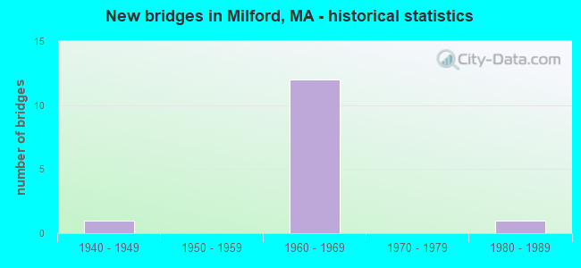
- New bridges - historical statistics
- 11940-1949
- 121960-1969
- 11980-1989


- Bridge Condition - Deck
- 7.1%Very good
- 7.1%Good
- 64.3%Satisfactory
- 21.4%Fair

- Bridge Condition - Superstructure
- 7.1%Very good
- 21.4%Good
- 35.7%Satisfactory
- 35.7%Fair

- Bridge Condition - Substructure
- 21.4%Good
- 57.1%Satisfactory
- 21.4%Fair

- Bridge Condition - Channel
- 50.0%Good
- 50.0%Satisfactory
Find on map >> Show street view
Structure Number: B060192ATDOTNBI, Location: 1 MI N OF ST-126 (Lat: 42.127361, Lng: -71.473781), Route carried "on" structure: City street , Year Built: 1966, Status: Open, Structure Length: 4.24m (13.91ft), Average Daily Traffic: 900 (year 2015), Truck Traffic: 3%, Average Future Daily Traffic: 1,421 (year 2032), Design Load: H 20, Features Intersected: I 495 NB, Facility Carried by Structure: HWY FARM ST
Minimum Vertical Clearance: 30+ m (98+ ft), Kilometerpoint: 0.000, Lanes on structure: 2, Lanes under structure: 3, Owner: State Highway Agency, Approaching Roadway Width: 11.0m (36.1ft), Skew: 4 degrees, Material/Design: Steel, Design/Construction: Stringer/Multi-beam, Number Of Spans In Main Unit: 1, Length of Maximum Span: 40.5m (132.9ft), Curb or Sidewalk Widths: Left: 1.5m (4.9ft), Right: 0.4m (1.3ft), Curb-To-Curb Width: 11.0m (36.1ft), Out-to-Out Width: 13.7m (44.9ft)
Condition: Deck: Satisfactory, Superstructure: Good, Substructure: Good, Operating Rating: 55.2 metric tons, Method Used To Determine Operating Rating: Load Factor (LF), Inventory Rating: 33.0 metric tons, Method Used To Determine Inventory Rating: Load Factor (LF), Structural Evaluation: Better than present minimum criteria, Deck Geometry: Equal to present minimum criteria, Underclear: High priority of corrective action, Approach Roadway Alignment: Equal to present desirable criteria, Length Of Structure Improvement: 4.30m (14.11ft), Designated Inspection Frequency: Every 24 months, Inspection Date: December 2021, Bridge Improvement Cost: $730,000, Roadway Improvement Cost: $74,000, Total Project Cost: $1,096,000 ( Estimate for 2022), Deck Structure Type: Concrete Cast-file-Place, Wearing Surface/Protective System: Wearing Surface: Bituminous, Membrane: Built-up
Find on map >> Show street view
Structure Number: B060192AUDOTNBI, Location: 1 MI N OF ST-126 (Lat: 42.126683, Lng: -71.474206), Route carried "on" structure: City street , Year Built: 1966, Status: Open, Structure Length: 4.15m (13.62ft), Average Daily Traffic: 900 (year 2013), Truck Traffic: 3%, Average Future Daily Traffic: 1,421 (year 2032), Design Load: H 20, Features Intersected: I 495 SB, Facility Carried by Structure: HWY FARM ST
Minimum Vertical Clearance: 30+ m (98+ ft), Kilometerpoint: 0.000, Lanes on structure: 2, Lanes under structure: 3, Owner: State Highway Agency, Approaching Roadway Width: 11.0m (36.1ft), Skew: 3 degrees, Material/Design: Steel, Design/Construction: Stringer/Multi-beam, Number Of Spans In Main Unit: 1, Length of Maximum Span: 40.5m (132.9ft), Curb or Sidewalk Widths: Left: 1.5m (4.9ft), Right: 0.3m (1.0ft), Curb-To-Curb Width: 11.0m (36.1ft), Out-to-Out Width: 13.7m (44.9ft)
Condition: Deck: Satisfactory, Superstructure: Satisfactory, Substructure: Good, Operating Rating: 55.2 metric tons, Method Used To Determine Operating Rating: Load Factor (LF), Inventory Rating: 33.0 metric tons, Method Used To Determine Inventory Rating: Load Factor (LF), Structural Evaluation: Equal to present minimum criteria, Deck Geometry: Equal to present minimum criteria, Underclear: High priority of corrective action, Approach Roadway Alignment: Equal to present desirable criteria, Length Of Structure Improvement: 4.20m (13.78ft), Designated Inspection Frequency: Every 24 months, Inspection Date: December 2021, Bridge Improvement Cost: $713,000, Roadway Improvement Cost: $72,000, Total Project Cost: $1,070,000 ( Estimate for 2022), Deck Structure Type: Concrete Cast-file-Place, Wearing Surface/Protective System: Wearing Surface: Bituminous, Membrane: Built-up
Find on map >> Show street view
Structure Number: M210051JPMUNNBI, Location: 1M N OF RT140 @UPTN LINE (Lat: 42.165606, Lng: -71.564344), Route carried "on" structure: City street , Year Built: 1945, Year Reconstructed: 2017, Status: Open, Structure Length: 0.73m (2.40ft), Average Daily Traffic: 3,208 (year 2018), Truck Traffic: 5%, Average Future Daily Traffic: 8,212 (year 2032), Design Load: HL 93, Features Intersected: WATER MILL RIVER, Facility Carried by Structure: HWY FISKE ML RD
Minimum Vertical Clearance: 30+ m (98+ ft), Kilometerpoint: 0.016, Lanes on structure: 2, Owner: Town or Township Highway Agency, Approaching Roadway Width: 7.3m (24.0ft), Skew: 2 degrees, Material/Design: Steel, Design/Construction: Stringer/Multi-beam, Number Of Spans In Main Unit: 1, Length of Maximum Span: 6.6m (21.7ft), Curb-To-Curb Width: 7.3m (24.0ft), Out-to-Out Width: 8.2m (26.9ft)
Condition: Deck: Very good, Superstructure: Very good, Substructure: Good, Channel: Good, Operating Rating: 45.4 metric tons, Method Used To Determine Operating Rating: Load and Resistance Factor Rating (LRFR) rating reported by rating factor(RF) method using HL-93 loadings, Inventory Rating: 35.6 metric tons, Method Used To Determine Inventory Rating: Load and Resistance Factor Rating (LRFR) rating reported by rating factor(RF) method using HL-93 loadings, Structural Evaluation: Better than present minimum criteria, Deck Geometry: High priority of replacement, Waterway Adequacy: Better than present minimum criteria, Approach Roadway Alignment: Equal to present minimum criteria, Designated Inspection Frequency: Every 24 months, Inspection Date: November 2021, Deck Structure Type: Concrete Cast-file-Place, Wearing Surface/Protective System: Wearing Surface: Bituminous, Membrane: Built-up, Deck Protection: Epoxy Coated Reinforcing
Find on map >> Show street view
Structure Number: M210151EFMUNNBI, Location: 0.1 MI E OF PURCHASE ST (Lat: 42.155806, Lng: -71.520625), Route carried "on" structure: City street , Year Built: 1980, Status: Open, Structure Length: 0.79m (2.59ft), Average Daily Traffic: 20,000 (year 2014), Truck Traffic: 7%, Average Future Daily Traffic: 51,738 (year 2031), Design Load: H 20, Features Intersected: WATER LOUISA LAKE OTLT, Facility Carried by Structure: HWY DILLA ST
Minimum Vertical Clearance: 30+ m (98+ ft), Kilometerpoint: 0.161, Lanes on structure: 2, Owner: Town or Township Highway Agency, Approaching Roadway Width: 9.8m (32.2ft), Material/Design: Prestressed concrete, Design/Construction: Slab, Number Of Spans In Main Unit: 1, Length of Maximum Span: 7.0m (23.0ft), Curb or Sidewalk Widths: Left: 1.8m (5.9ft), Right: 1.8m (5.9ft), Curb-To-Curb Width: 9.8m (32.2ft), Out-to-Out Width: 14.3m (46.9ft)
Condition: Deck: Fair, Superstructure: Fair, Substructure: Fair, Channel: Satisfactory, Operating Rating: 34.7 metric tons, Method Used To Determine Operating Rating: Load Testing, Inventory Rating: 20.8 metric tons, Method Used To Determine Inventory Rating: Load Testing, Structural Evaluation: Somewhat better than minimum adequacy, Deck Geometry: Meets minimum limits, Waterway Adequacy: Equal to present desirable criteria, Approach Roadway Alignment: Equal to present desirable criteria, Length Of Structure Improvement: 0.80m (2.62ft), Designated Inspection Frequency: Every 24 months, Inspection Date: November 2020, Bridge Improvement Cost: $450,000, Roadway Improvement Cost: $46,000, Total Project Cost: $676,000 ( Estimate for 2022), Deck Structure Type: Concrete Precast Panels, Wearing Surface/Protective System: Wearing Surface: Bituminous, Membrane: Built-up
Find on map >> Show street view
Structure Number: M210171UFDOTNBI, Location: JUST S. OF MM 48.8 (Lat: 42.152744, Lng: -71.486894), Route carried "on" structure: Interstate 495, Year Built: 1968, Status: Open, Structure Length: 2.38m (7.81ft), Average Daily Traffic: 47,316 (year 2019), Truck Traffic: 3%, Average Future Daily Traffic: 61,119 (year 2032), Design Load: HS 20+Mod, Features Intersected: OTHER BIKE TRAIL
Minimum Vertical Clearance: 30+ m (98+ ft), Kilometerpoint: 78.549, Lanes on structure: 3, Base Highway Network: Yes, Owner: State Highway Agency, Approaching Roadway Width: 15.5m (50.9ft), Skew: 9 degrees, Material/Design: Steel, Design/Construction: Stringer/Multi-beam, Number Of Spans In Main Unit: 1, Length of Maximum Span: 22.3m (73.2ft), Curb or Sidewalk Widths: Left: 0.8m (2.6ft), Right: 0.8m (2.6ft), Curb-To-Curb Width: 15.5m (50.9ft), Out-to-Out Width: 17.1m (56.1ft)
Condition: Deck: Satisfactory, Superstructure: Good, Substructure: Satisfactory, Operating Rating: 51.3 metric tons, Method Used To Determine Operating Rating: Allowable Stress (AS), Inventory Rating: 29.7 metric tons, Method Used To Determine Inventory Rating: Allowable Stress (AS), Structural Evaluation: Equal to present minimum criteria, Deck Geometry: Somewhat better than minimum adequacy, Approach Roadway Alignment: Equal to present desirable criteria, Length Of Structure Improvement: 2.40m (7.87ft), Designated Inspection Frequency: Every 24 months, Inspection Date: May 2021, Bridge Improvement Cost: $1,613,000, Roadway Improvement Cost: $162,000, Total Project Cost: $2,420,000 ( Estimate for 2022), Deck Structure Type: Concrete Cast-file-Place, Wearing Surface/Protective System: Wearing Surface: Bituminous, Membrane: Built-up
Find on map >> Show street view
Structure Number: M210171UGDOTNBI, Location: .1 MI. STH. OF ST-16 (Lat: 42.153014, Lng: -71.486328), Route carried "on" structure: Interstate 495, Year Built: 1968, Status: Open, Structure Length: 2.33m (7.64ft), Average Daily Traffic: 43,525 (year 2019), Truck Traffic: 7%, Average Future Daily Traffic: 61,119 (year 2032), Design Load: HS 20+Mod, Features Intersected: OTHER BIKE TRAIL
Minimum Vertical Clearance: 30+ m (98+ ft), Kilometerpoint: 78.549, Lanes on structure: 3, Base Highway Network: Yes, Owner: State Highway Agency, Approaching Roadway Width: 15.7m (51.5ft), Skew: 1 degrees, Material/Design: Steel, Design/Construction: Stringer/Multi-beam, Number Of Spans In Main Unit: 1, Length of Maximum Span: 21.9m (71.9ft), Curb-To-Curb Width: 15.7m (51.5ft), Out-to-Out Width: 17.1m (56.1ft)
Condition: Deck: Satisfactory, Superstructure: Satisfactory, Substructure: Satisfactory, Operating Rating: 53.2 metric tons, Method Used To Determine Operating Rating: Load Factor (LF), Inventory Rating: 31.9 metric tons, Method Used To Determine Inventory Rating: Load Factor (LF), Structural Evaluation: Equal to present minimum criteria, Deck Geometry: Somewhat better than minimum adequacy, Approach Roadway Alignment: Equal to present desirable criteria, Length Of Structure Improvement: 2.40m (7.87ft), Designated Inspection Frequency: Every 24 months, Inspection Date: May 2021, Bridge Improvement Cost: $1,613,000, Roadway Improvement Cost: $162,000, Total Project Cost: $2,420,000 ( Estimate for 2022), Deck Structure Type: Concrete Cast-file-Place, Wearing Surface/Protective System: Wearing Surface: Bituminous, Membrane: Built-up
Find on map >> Show street view
Structure Number: M210181UMDOTNBI, Location: .9 MI S OF HOPKINTON T.L. (Lat: 42.181525, Lng: -71.527778), Route carried "on" structure: Interstate 495, Year Built: 1967, Status: Open, Structure Length: 2.62m (8.60ft), Average Daily Traffic: 51,670 (year 2017), Truck Traffic: 6%, Average Future Daily Traffic: 63,172 (year 2031), Design Load: HS 20+Mod, Features Intersected: HWY HAVEN ST
Minimum Vertical Clearance: 30+ m (98+ ft), Kilometerpoint: 83.249, Lanes on structure: 3, Lanes under structure: 2, Base Highway Network: Yes, Owner: State Highway Agency, Approaching Roadway Width: 15.2m (49.9ft), Skew: 1 degrees, Material/Design: Steel, Design/Construction: Stringer/Multi-beam, Number Of Spans In Main Unit: 1, Length of Maximum Span: 24.1m (79.1ft), Curb-To-Curb Width: 15.2m (49.9ft), Out-to-Out Width: 17.1m (56.1ft)
Condition: Deck: Fair, Superstructure: Good, Substructure: Satisfactory, Operating Rating: 51.3 metric tons, Method Used To Determine Operating Rating: Load Factor (LF), Inventory Rating: 30.7 metric tons, Method Used To Determine Inventory Rating: Load Factor (LF), Structural Evaluation: Equal to present minimum criteria, Deck Geometry: Meets minimum limits, Underclear: Somewhat better than minimum adequacy, Approach Roadway Alignment: Equal to present desirable criteria, Length Of Structure Improvement: 2.70m (8.86ft), Designated Inspection Frequency: Every 24 months, Inspection Date: September 2020, Bridge Improvement Cost: $1,814,000, Roadway Improvement Cost: $182,000, Total Project Cost: $2,722,000 ( Estimate for 2022), Deck Structure Type: Concrete Cast-file-Place, Wearing Surface/Protective System: Wearing Surface: Bituminous, Membrane: Built-up
Find on map >> Show street view
Structure Number: M210181UNDOTNBI, Location: .9 MI. S. HOPKINTON T.L. (Lat: 42.180511, Lng: -71.528625), Route carried "on" structure: Interstate 495, Year Built: 1967, Status: Open, Structure Length: 2.71m (8.89ft), Average Daily Traffic: 45,652 (year 2019), Truck Traffic: 4%, Average Future Daily Traffic: 63,172 (year 2031), Design Load: HS 20+Mod, Features Intersected: HWY HAVEN ST
Minimum Vertical Clearance: 30+ m (98+ ft), Kilometerpoint: 83.249, Lanes on structure: 3, Lanes under structure: 2, Base Highway Network: Yes, Owner: State Highway Agency, Approaching Roadway Width: 15.2m (49.9ft), Skew: 1 degrees, Material/Design: Steel, Design/Construction: Stringer/Multi-beam, Number Of Spans In Main Unit: 1, Length of Maximum Span: 25.0m (82.0ft), Curb-To-Curb Width: 15.2m (49.9ft), Out-to-Out Width: 17.1m (56.1ft)
Condition: Deck: Fair, Superstructure: Fair, Substructure: Fair, Operating Rating: 57.6 metric tons, Method Used To Determine Operating Rating: Load Factor (LF), Inventory Rating: 34.5 metric tons, Method Used To Determine Inventory Rating: Load Factor (LF), Structural Evaluation: Somewhat better than minimum adequacy, Deck Geometry: Meets minimum limits, Underclear: Equal to present minimum criteria, Approach Roadway Alignment: Equal to present desirable criteria, Length Of Structure Improvement: 2.80m (9.19ft), Designated Inspection Frequency: Every 24 months, Inspection Date: September 2020, Bridge Improvement Cost: $1,881,000, Roadway Improvement Cost: $189,000, Total Project Cost: $2,822,000 ( Estimate for 2022), Deck Structure Type: Concrete Cast-file-Place, Wearing Surface/Protective System: Wearing Surface: Bituminous, Membrane: Built-up
Find on map >> Show street view
Structure Number: M210201UKDOTNBI, Location: 1 MI. N. OF ST.16 (Lat: 42.166669, Lng: -71.508772), Route carried "on" structure: Interstate 495, Year Built: 1967, Status: Open, Structure Length: 3.35m (10.99ft), Average Daily Traffic: 32,947 (year 2020), Truck Traffic: 14%, Average Future Daily Traffic: 102,654 (year 2032), Design Load: H 20, Features Intersected: ST 85 CEDAR ST
Minimum Vertical Clearance: 30+ m (98+ ft), Kilometerpoint: 81.072, Lanes on structure: 3, Lanes under structure: 4, Base Highway Network: Yes, Owner: State Highway Agency, Approaching Roadway Width: 15.2m (49.9ft), Skew: 3 degrees, Material/Design: Steel, Design/Construction: Stringer/Multi-beam, Number Of Spans In Main Unit: 1, Length of Maximum Span: 32.0m (105.0ft), Curb-To-Curb Width: 15.2m (49.9ft), Out-to-Out Width: 17.4m (57.1ft)
Condition: Deck: Good, Superstructure: Satisfactory, Substructure: Satisfactory, Operating Rating: 51.1 metric tons, Method Used To Determine Operating Rating: Load Factor (LF), Inventory Rating: 30.6 metric tons, Method Used To Determine Inventory Rating: Load Factor (LF), Structural Evaluation: Equal to present minimum criteria, Deck Geometry: Meets minimum limits, Underclear: High priority of corrective action, Approach Roadway Alignment: Equal to present desirable criteria, Length Of Structure Improvement: 3.40m (11.15ft), Designated Inspection Frequency: Every 24 months, Inspection Date: August 2021, Bridge Improvement Cost: $2,324,000, Roadway Improvement Cost: $233,000, Total Project Cost: $3,487,000 ( Estimate for 2022), Deck Structure Type: Concrete Cast-file-Place, Wearing Surface/Protective System: Wearing Surface: Bituminous, Membrane: Built-up
Find on map >> Show street view
Structure Number: M210201ULDOTNBI, Location: 1 MI. N. OF ST.16 (Lat: 42.166203, Lng: -71.508742), Route carried "on" structure: Interstate 495, Year Built: 1967, Status: Open, Structure Length: 3.29m (10.79ft), Average Daily Traffic: 32,792 (year 2020), Truck Traffic: 14%, Average Future Daily Traffic: 102,654 (year 2032), Design Load: HS 20+Mod, Features Intersected: ST 85 CEDAR ST
Minimum Vertical Clearance: 30+ m (98+ ft), Kilometerpoint: 81.072, Lanes on structure: 3, Lanes under structure: 3, Base Highway Network: Yes, Owner: State Highway Agency, Approaching Roadway Width: 15.2m (49.9ft), Skew: 3 degrees, Material/Design: Steel, Design/Construction: Stringer/Multi-beam, Number Of Spans In Main Unit: 1, Length of Maximum Span: 31.4m (103.0ft), Curb-To-Curb Width: 15.2m (49.9ft), Out-to-Out Width: 17.4m (57.1ft)
Condition: Deck: Satisfactory, Superstructure: Satisfactory, Substructure: Satisfactory, Operating Rating: 48.6 metric tons, Method Used To Determine Operating Rating: Allowable Stress (AS), Inventory Rating: 32.4 metric tons, Method Used To Determine Inventory Rating: Allowable Stress (AS), Structural Evaluation: Equal to present minimum criteria, Deck Geometry: Meets minimum limits, Underclear: High priority of corrective action, Approach Roadway Alignment: Equal to present desirable criteria, Length Of Structure Improvement: 3.30m (10.83ft), Designated Inspection Frequency: Every 24 months, Inspection Date: August 2021, Bridge Improvement Cost: $996,000, Roadway Improvement Cost: $100,000, Total Project Cost: $1,495,000 ( Estimate for 2022), Deck Structure Type: Concrete Cast-file-Place, Wearing Surface/Protective System: Wearing Surface: Bituminous, Membrane: Built-up
Find on map >> Show street view
Structure Number: M210211UHDOTNBI, Location: .5 MI. N. OF ST-109 (Lat: 42.154614, Lng: -71.488169), Route carried "on" structure: Interstate 495, Year Built: 1968, Status: Open, Structure Length: 2.93m (9.61ft), Average Daily Traffic: 47,316 (year 2019), Truck Traffic: 7%, Average Future Daily Traffic: 55,276 (year 2031), Design Load: HS 20, Features Intersected: ST 16 E MAIN ST
Minimum Vertical Clearance: 30+ m (98+ ft), Kilometerpoint: 83.378, Lanes on structure: 3, Lanes under structure: 2, Base Highway Network: Yes, Owner: State Highway Agency, Approaching Roadway Width: 15.8m (51.8ft), Skew: 1 degrees, Material/Design: Steel, Design/Construction: Stringer/Multi-beam, Number Of Spans In Main Unit: 1, Length of Maximum Span: 26.8m (87.9ft), Curb or Sidewalk Widths: Left: 0.2m (0.7ft), Right: 0.2m (0.7ft), Curb-To-Curb Width: 15.8m (51.8ft), Out-to-Out Width: 17.4m (57.1ft)
Condition: Deck: Satisfactory, Superstructure: Fair, Substructure: Satisfactory, Operating Rating: 51.8 metric tons, Method Used To Determine Operating Rating: Load Factor (LF), Inventory Rating: 31.0 metric tons, Method Used To Determine Inventory Rating: Load Factor (LF), Structural Evaluation: Somewhat better than minimum adequacy, Deck Geometry: Somewhat better than minimum adequacy, Underclear: Meets minimum limits, Approach Roadway Alignment: Equal to present desirable criteria, Length Of Structure Improvement: 3.00m (9.84ft), Designated Inspection Frequency: Every 24 months, Inspection Date: July 2020, Bridge Improvement Cost: $2,051,000, Roadway Improvement Cost: $206,000, Total Project Cost: $3,077,000 ( Estimate for 2022), Deck Structure Type: Concrete Cast-file-Place, Wearing Surface/Protective System: Wearing Surface: Bituminous, Membrane: Built-up
Find on map >> Show street view
Structure Number: M210211UJDOTNBI, Location: .5 MI. NORTH OF STATE 109 (Lat: 42.155067, Lng: -71.487650), Route carried "on" structure: Interstate 495, Year Built: 1968, Status: Open, Structure Length: 2.93m (9.61ft), Average Daily Traffic: 43,525 (year 2019), Truck Traffic: 8%, Average Future Daily Traffic: 88,441 (year 2031), Design Load: HS 20+Mod, Features Intersected: ST 16 E MAIN ST
Minimum Vertical Clearance: 30+ m (98+ ft), Kilometerpoint: 83.378, Lanes on structure: 3, Lanes under structure: 2, Base Highway Network: Yes, Toll: On toll road, Owner: State Highway Agency, Approaching Roadway Width: 15.8m (51.8ft), Skew: 1 degrees, Material/Design: Steel, Design/Construction: Stringer/Multi-beam, Number Of Spans In Main Unit: 1, Length of Maximum Span: 26.8m (87.9ft), Curb or Sidewalk Widths: Left: 0.2m (0.7ft), Right: 0.2m (0.7ft), Curb-To-Curb Width: 15.8m (51.8ft), Out-to-Out Width: 17.4m (57.1ft)
Condition: Deck: Satisfactory, Superstructure: Fair, Substructure: Satisfactory, Operating Rating: 47.2 metric tons, Method Used To Determine Operating Rating: Load Factor (LF), Inventory Rating: 28.3 metric tons, Method Used To Determine Inventory Rating: Load Factor (LF), Structural Evaluation: Somewhat better than minimum adequacy, Deck Geometry: Somewhat better than minimum adequacy, Underclear: High priority of corrective action, Approach Roadway Alignment: Equal to present desirable criteria, Length Of Structure Improvement: 3.00m (9.84ft), Designated Inspection Frequency: Every 24 months, Inspection Date: July 2020, Bridge Improvement Cost: $2,051,000, Roadway Improvement Cost: $206,000, Total Project Cost: $3,077,000 ( Estimate for 2022), Deck Structure Type: Concrete Cast-file-Place, Wearing Surface/Protective System: Wearing Surface: Bituminous, Membrane: Built-up
Find on map >> Show street view
Structure Number: M210221UDDOTNBI, Location: 1 MI. S. OF ST-16 (Lat: 42.147514, Lng: -71.484239), Route carried "on" structure: Interstate 495, Year Built: 1968, Status: Open, Structure Length: 4.30m (14.11ft), Average Daily Traffic: 35,958 (year 2019), Truck Traffic: 7%, Average Future Daily Traffic: 63,488 (year 2031), Design Load: HS 20, Features Intersected: ST109 MEDWAY RD
Minimum Vertical Clearance: 30+ m (98+ ft), Kilometerpoint: 77.938, Lanes on structure: 3, Lanes under structure: 2, Base Highway Network: Yes, Owner: State Highway Agency, Approaching Roadway Width: 15.5m (50.9ft), Skew: 2 degrees, Material/Design: Steel, Design/Construction: Stringer/Multi-beam, Number Of Spans In Main Unit: 2, Length of Maximum Span: 20.4m (66.9ft), Curb-To-Curb Width: 15.5m (50.9ft), Out-to-Out Width: 17.1m (56.1ft)
Condition: Deck: Satisfactory, Superstructure: Satisfactory, Substructure: Fair, Operating Rating: 50.5 metric tons, Method Used To Determine Operating Rating: Load Factor (LF), Inventory Rating: 30.3 metric tons, Method Used To Determine Inventory Rating: Load Factor (LF), Structural Evaluation: Somewhat better than minimum adequacy, Deck Geometry: Somewhat better than minimum adequacy, Underclear: High priority of corrective action, Approach Roadway Alignment: Equal to present desirable criteria, Length Of Structure Improvement: 4.40m (14.44ft), Designated Inspection Frequency: Every 24 months, Inspection Date: July 2020, Bridge Improvement Cost: $2,956,000, Roadway Improvement Cost: $296,000, Total Project Cost: $4,435,000 ( Estimate for 2022), Deck Structure Type: Concrete Cast-file-Place, Wearing Surface/Protective System: Wearing Surface: Bituminous, Membrane: Built-up
Find on map >> Show street view
Structure Number: M210221UEDOTNBI, Location: 1 MI S OF ST-16 (Lat: 42.147542, Lng: -71.484728), Route carried "on" structure: Interstate 495, Year Built: 1968, Status: Open, Structure Length: 4.30m (14.11ft), Average Daily Traffic: 47,316 (year 2019), Truck Traffic: 7%, Average Future Daily Traffic: 63,488 (year 2031), Design Load: HS 20, Features Intersected: ST109 MEDWAY RD
Minimum Vertical Clearance: 30+ m (98+ ft), Kilometerpoint: 77.938, Lanes on structure: 3, Lanes under structure: 4, Base Highway Network: Yes, Owner: State Highway Agency, Approaching Roadway Width: 15.5m (50.9ft), Skew: 2 degrees, Material/Design: Steel, Design/Construction: Stringer/Multi-beam, Number Of Spans In Main Unit: 2, Length of Maximum Span: 20.4m (66.9ft), Curb-To-Curb Width: 15.5m (50.9ft), Out-to-Out Width: 17.1m (56.1ft)
Condition: Deck: Satisfactory, Superstructure: Fair, Substructure: Satisfactory, Operating Rating: 49.2 metric tons, Method Used To Determine Operating Rating: Load Factor (LF), Inventory Rating: 29.5 metric tons, Method Used To Determine Inventory Rating: Load Factor (LF), Structural Evaluation: Somewhat better than minimum adequacy, Deck Geometry: Somewhat better than minimum adequacy, Underclear: High priority of corrective action, Approach Roadway Alignment: Equal to present desirable criteria, Length Of Structure Improvement: 4.40m (14.44ft), Designated Inspection Frequency: Every 24 months, Inspection Date: July 2020, Bridge Improvement Cost: $2,956,000, Roadway Improvement Cost: $296,000, Total Project Cost: $4,435,000 ( Estimate for 2022), Deck Structure Type: Concrete Cast-file-Place, Wearing Surface/Protective System: Wearing Surface: Bituminous, Membrane: Built-up