Bridge Statistics for Middlebury, Connecticut (CT)
Condition, Traffic, Stress, Structural Evaluation, Project Costs
- National Bridge Inventory (NBI) Statistics
- 29Number of bridges
- 299ft / 90.7mTotal length
- $9,335,000Total costs
- 689,915Total average daily traffic
- 72,940Total average daily truck traffic
- National Bridge Inventory (NBI) Registered Bridges for Middlebury
- No street view available for this location
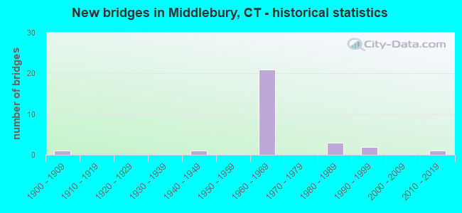
- New bridges - historical statistics
- 11900-1909
- 11940-1949
- 211960-1969
- 31980-1989
- 21990-1999
- 12010-2019

- Reconstructed bridges - Historical Statistics
- 11930-1939
- 01940-1949
- 01950-1959
- 01960-1969
- 01970-1979
- 31980-1989
- 11990-1999
- 12000-2009


- Bridge Condition - Deck
- 23.5%Good
- 47.1%Satisfactory
- 23.5%Fair
- 5.9%Poor

- Bridge Condition - Superstructure
- 21.1%Good
- 36.8%Satisfactory
- 42.1%Fair

- Bridge Condition - Substructure
- 5.3%Very good
- 31.6%Good
- 52.6%Satisfactory
- 10.5%Fair

- Bridge Condition - Channel
- 55.6%Good
- 22.2%Satisfactory
- 11.1%Fair
- 11.1%Poor

- Bridge Condition - Culverts
- 66.7%Good
- 33.3%Satisfactory
Find on map >> Show street view
Structure Number: 117, Location: I-95 SOUTHBOUND EXIT 29 (Lat: 41.176856, Lng: -73.170819), Route carried "on" structure: Ramp Interstate 95, Year Built: 1999, Status: Open, Structure Length: 3.66m (12.01ft), Average Daily Traffic: 4,800 (year 2017), Truck Traffic: 9%, Average Future Daily Traffic: 7,132 (year 2037), Design Load: HS 20, Features Intersected: ROUTE 130 EB
Minimum Vertical Clearance: 30+ m (98+ ft), Kilometerpoint: 0.402, Lanes on structure: 1, Lanes under structure: 2, Owner: State Highway Agency, Approaching Roadway Width: 9.8m (32.2ft), Skew: 2 degrees, Material/Design: Steel, Design/Construction: Stringer/Multi-beam, Number Of Spans In Main Unit: 1, Length of Maximum Span: 35.4m (116.1ft), Curb-To-Curb Width: 9.8m (32.2ft), Out-to-Out Width: 10.8m (35.4ft)
Condition: Deck: Good, Superstructure: Good, Substructure: Good, Inventory Rating: 74.4 metric tons, Method Used To Determine Inventory Rating: Load Factor (LF), Structural Evaluation: Better than present minimum criteria, Deck Geometry: Superior to present desirable criteria, Underclear: Equal to present minimum criteria, Approach Roadway Alignment: Better than present minimum criteria, Designated Inspection Frequency: Every 24 months, Inspection Date: May 2020, Deck Structure Type: Concrete Cast-file-Place, Wearing Surface/Protective System: Wearing Surface: Bituminous, Membrane: Built-up, Deck Protection: Epoxy Coated Reinforcing
Find on map >> Show street view
Structure Number: 116, Location: 0.8 MI EAST OF ROUTE 188 (Lat: 41.501447, Lng: -73.151631), Route carried "on" structure: City street , Year Built: 1964, Status: Open, Structure Length: 8.99m (29.49ft), Average Daily Traffic: 2,083 (year 2020), Truck Traffic: 5%, Average Future Daily Traffic: 3,095 (year 2040), Design Load: HS 20, Features Intersected: INTERSTATE 84, Facility Carried by Structure: BENSON ROAD
Minimum Vertical Clearance: 30+ m (98+ ft), Kilometerpoint: 1.658, Lanes on structure: 2, Lanes under structure: 4, Owner: State Highway Agency, Approaching Roadway Width: 9.1m (29.9ft), Skew: 2 degrees, Material/Design: Steel, Design/Construction: Stringer/Multi-beam, Number Of Spans In Main Unit: 4, Length of Maximum Span: 32.3m (106.0ft), Curb or Sidewalk Widths: Left: 0.5m (1.6ft), Right: 0.5m (1.6ft), Curb-To-Curb Width: 9.1m (29.9ft), Out-to-Out Width: 10.8m (35.4ft)
Condition: Deck: Poor, Superstructure: Satisfactory, Substructure: Satisfactory, Operating Rating: 63.5 metric tons, Method Used To Determine Operating Rating: Load Factor (LF), Inventory Rating: 38.1 metric tons, Method Used To Determine Inventory Rating: Load Factor (LF), Structural Evaluation: Equal to present minimum criteria, Deck Geometry: Meets minimum limits, Underclear: Somewhat better than minimum adequacy, Approach Roadway Alignment: Equal to present desirable criteria, Designated Inspection Frequency: Every 24 months, Inspection Date: August 2020, Total Project Cost: $6,500,000 ( Estimate for 2017), Deck Structure Type: Concrete Cast-file-Place, Wearing Surface/Protective System: Wearing Surface: Monolithic Concrete
Find on map >> Show street view
Structure Number: 1161, Location: 1.4 MI EAST OF EXIT 16 (Lat: 41.507186, Lng: -73.141594), Route carried "on" structure: City street , Year Built: 1964, Year Reconstructed: 1996, Status: Open, Structure Length: 9.88m (32.41ft), Average Daily Traffic: 4,669 (year 2020), Truck Traffic: 5%, Average Future Daily Traffic: 6,938 (year 2040), Design Load: HS 20, Features Intersected: INTERSTATE 84, Facility Carried by Structure: CHRISTIAN ROAD
Minimum Vertical Clearance: 30+ m (98+ ft), Kilometerpoint: 42.551, Lanes on structure: 2, Lanes under structure: 4, Owner: State Highway Agency, Approaching Roadway Width: 11.0m (36.1ft), Material/Design: Steel, Design/Construction: Stringer/Multi-beam, Number Of Spans In Main Unit: 4, Length of Maximum Span: 32.6m (107.0ft), Curb-To-Curb Width: 11.0m (36.1ft), Out-to-Out Width: 12.1m (39.7ft)
Condition: Deck: Good, Superstructure: Satisfactory, Substructure: Satisfactory, Operating Rating: 38.2 metric tons, Method Used To Determine Operating Rating: Load and Resistance Factor Rating (LRFR) rating reported by rating factor(RF) method using HL-93 loadings, Inventory Rating: 29.5 metric tons, Method Used To Determine Inventory Rating: Load and Resistance Factor Rating (LRFR) rating reported by rating factor(RF) method using HL-93 loadings, Structural Evaluation: Equal to present minimum criteria, Deck Geometry: Somewhat better than minimum adequacy, Underclear: Somewhat better than minimum adequacy, Approach Roadway Alignment: Equal to present desirable criteria, Designated Inspection Frequency: Every 24 months, Inspection Date: August 2020, Total Project Cost: $1,035,000 ( Estimate for 2015), Deck Structure Type: Concrete Cast-file-Place, Wearing Surface/Protective System: Wearing Surface: Bituminous, Membrane: Preformed Fabric, Deck Protection: Epoxy Coated Reinforcing
Find on map >> Show street view
Structure Number: 1162, Location: 1.3 MI E MDBRY-SOBRY TL (Lat: 41.508844, Lng: -73.137811), Route carried "on" structure: Interstate 84, Year Built: 1964, Year Reconstructed: 1991, Status: Open, Structure Length: 4.79m (15.72ft), Average Daily Traffic: 36,900 (year 2018), Truck Traffic: 14%, Average Future Daily Traffic: 54,830 (year 2038), Design Load: HS 20, Features Intersected: LONG MEADOW ROAD
Minimum Vertical Clearance: 30+ m (98+ ft), Kilometerpoint: 42.535, Lanes on structure: 2, Lanes under structure: 2, Base Highway Network: Yes, Owner: State Highway Agency, Approaching Roadway Width: 11.9m (39.0ft), Skew: 2 degrees, Material/Design: Steel, Design/Construction: Stringer/Multi-beam, Number Of Spans In Main Unit: 3, Length of Maximum Span: 17.1m (56.1ft), Curb-To-Curb Width: 12.1m (39.7ft), Out-to-Out Width: 13.3m (43.6ft)
Condition: Deck: Fair, Superstructure: Satisfactory, Substructure: Good, Operating Rating: 50.9 metric tons, Method Used To Determine Operating Rating: Load and Resistance Factor Rating (LRFR) rating reported by rating factor(RF) method using HL-93 loadings, Inventory Rating: 39.2 metric tons, Method Used To Determine Inventory Rating: Load and Resistance Factor Rating (LRFR) rating reported by rating factor(RF) method using HL-93 loadings, Structural Evaluation: Equal to present minimum criteria, Deck Geometry: Equal to present minimum criteria, Approach Roadway Alignment: Equal to present desirable criteria, Designated Inspection Frequency: Every 24 months, Inspection Date: June 2020, Deck Structure Type: Concrete Cast-file-Place, Wearing Surface/Protective System: Wearing Surface: Bituminous, Membrane: Preformed Fabric
Find on map >> Show street view
Structure Number: 1163, Location: 1.3 MI E MDBY-SOBRY TL (Lat: 41.509158, Lng: -73.137853), Route carried "on" structure: Interstate 84, Year Built: 1964, Year Reconstructed: 1991, Status: Open, Structure Length: 4.72m (15.49ft), Average Daily Traffic: 36,800 (year 2018), Truck Traffic: 9%, Average Future Daily Traffic: 54,681 (year 2038), Design Load: HS 20, Features Intersected: LONG MEADOW ROAD
Minimum Vertical Clearance: 30+ m (98+ ft), Kilometerpoint: 42.551, Lanes on structure: 2, Lanes under structure: 2, Base Highway Network: Yes, Owner: State Highway Agency, Approaching Roadway Width: 11.9m (39.0ft), Skew: 1 degrees, Material/Design: Steel, Design/Construction: Stringer/Multi-beam, Number Of Spans In Main Unit: 3, Length of Maximum Span: 16.8m (55.1ft), Curb-To-Curb Width: 12.1m (39.7ft), Out-to-Out Width: 13.3m (43.6ft)
Condition: Deck: Fair, Superstructure: Satisfactory, Substructure: Satisfactory, Operating Rating: 51.8 metric tons, Method Used To Determine Operating Rating: Load and Resistance Factor Rating (LRFR) rating reported by rating factor(RF) method using HL-93 loadings, Inventory Rating: 39.9 metric tons, Method Used To Determine Inventory Rating: Load and Resistance Factor Rating (LRFR) rating reported by rating factor(RF) method using HL-93 loadings, Structural Evaluation: Equal to present minimum criteria, Deck Geometry: Equal to present minimum criteria, Underclear: Somewhat better than minimum adequacy, Approach Roadway Alignment: Equal to present desirable criteria, Designated Inspection Frequency: Every 24 months, Inspection Date: June 2020, Deck Structure Type: Concrete Cast-file-Place, Wearing Surface/Protective System: Wearing Surface: Bituminous, Membrane: Preformed Fabric
Find on map >> Show street view
Structure Number: 1164, Location: 2.3 MI E SOUTHBURY TL (Lat: 41.513864, Lng: -73.122075), Route carried "on" structure: City street , Year Built: 1964, Status: Open, Structure Length: 11.61m (38.09ft), Average Daily Traffic: 857 (year 2021), Truck Traffic: 7%, Average Future Daily Traffic: 1,273 (year 2041), Design Load: H 20, Features Intersected: INTERSTATE 84, Facility Carried by Structure: SOUTH STREET
Minimum Vertical Clearance: 30+ m (98+ ft), Kilometerpoint: 2.784, Lanes on structure: 2, Lanes under structure: 5, Owner: State Highway Agency, Approaching Roadway Width: 10.4m (34.1ft), Material/Design: Steel, Design/Construction: Arch - Deck, Number Of Spans In Main Unit: 1, Number Of Approach Spans: 6, Length of Maximum Span: 58.8m (192.9ft), Curb or Sidewalk Widths: Left: 0.5m (1.6ft), Right: 0.5m (1.6ft), Curb-To-Curb Width: 10.4m (34.1ft), Out-to-Out Width: 11.9m (39.0ft)
Condition: Deck: Fair, Superstructure: Fair, Substructure: Good, Operating Rating: 35.3 metric tons, Method Used To Determine Operating Rating: Load and Resistance Factor Rating (LRFR) rating reported by rating factor(RF) method using HL-93 loadings, Inventory Rating: 27.2 metric tons, Method Used To Determine Inventory Rating: Load and Resistance Factor Rating (LRFR) rating reported by rating factor(RF) method using HL-93 loadings, Structural Evaluation: Somewhat better than minimum adequacy, Deck Geometry: Equal to present minimum criteria, Underclear: Better than present minimum criteria, Approach Roadway Alignment: Equal to present desirable criteria, Designated Inspection Frequency: Every 24 months, Inspection Date: November 2021, Total Project Cost: $1,800,000 ( Estimate for 2019), Deck Structure Type: Concrete Cast-file-Place, Wearing Surface/Protective System: Wearing Surface: Monolithic Concrete
Find on map >> Show street view
Structure Number: 1165, Location: 0.6 MI E OF SOUTH ST BR (Lat: 41.516783, Lng: -73.110353), Route carried "on" structure: Interstate 84, Year Built: 1964, Status: Open, Structure Length: 6.46m (21.19ft), Average Daily Traffic: 35,350 (year 2016), Truck Traffic: 9%, Average Future Daily Traffic: 52,527 (year 2036), Design Load: HS 20, Features Intersected: SANDY HILL ROAD
Minimum Vertical Clearance: 30+ m (98+ ft), Kilometerpoint: 44.981, Lanes on structure: 2, Lanes under structure: 2, Base Highway Network: Yes, Owner: State Highway Agency, Approaching Roadway Width: 12.2m (40.0ft), Skew: 1 degrees, Material/Design: Steel, Design/Construction: Stringer/Multi-beam, Number Of Spans In Main Unit: 3, Length of Maximum Span: 25.3m (83.0ft), Curb-To-Curb Width: 12.1m (39.7ft), Out-to-Out Width: 13.3m (43.6ft)
Condition: Deck: Satisfactory, Superstructure: Fair, Substructure: Satisfactory, Operating Rating: 49.6 metric tons, Method Used To Determine Operating Rating: Load and Resistance Factor Rating (LRFR) rating reported by rating factor(RF) method using HL-93 loadings, Inventory Rating: 38.2 metric tons, Method Used To Determine Inventory Rating: Load and Resistance Factor Rating (LRFR) rating reported by rating factor(RF) method using HL-93 loadings, Structural Evaluation: Somewhat better than minimum adequacy, Deck Geometry: Equal to present minimum criteria, Underclear: Better than present minimum criteria, Approach Roadway Alignment: Equal to present desirable criteria, Designated Inspection Frequency: Every 24 months, Inspection Date: July 2020, Deck Structure Type: Concrete Cast-file-Place, Wearing Surface/Protective System: Wearing Surface: Bituminous, Membrane: Preformed Fabric
Find on map >> Show street view
Structure Number: 1166, Location: 2.0 MI W OF RT 63 (Lat: 41.517075, Lng: -73.110361), Route carried "on" structure: Interstate 84, Year Built: 1964, Status: Open, Structure Length: 6.46m (21.19ft), Average Daily Traffic: 35,350 (year 2016), Truck Traffic: 9%, Average Future Daily Traffic: 52,527 (year 2036), Design Load: HS 20, Features Intersected: SANDY HILL ROAD
Minimum Vertical Clearance: 30+ m (98+ ft), Kilometerpoint: 44.997, Lanes on structure: 3, Lanes under structure: 2, Base Highway Network: Yes, Owner: State Highway Agency, Approaching Roadway Width: 13.4m (44.0ft), Skew: 1 degrees, Material/Design: Steel, Design/Construction: Stringer/Multi-beam, Number Of Spans In Main Unit: 3, Length of Maximum Span: 25.3m (83.0ft), Curb-To-Curb Width: 13.4m (44.0ft), Out-to-Out Width: 14.5m (47.6ft)
Condition: Deck: Satisfactory, Superstructure: Fair, Substructure: Satisfactory, Operating Rating: 36.9 metric tons, Method Used To Determine Operating Rating: Load and Resistance Factor Rating (LRFR) rating reported by rating factor(RF) method using HL-93 loadings, Inventory Rating: 28.5 metric tons, Method Used To Determine Inventory Rating: Load and Resistance Factor Rating (LRFR) rating reported by rating factor(RF) method using HL-93 loadings, Structural Evaluation: Somewhat better than minimum adequacy, Deck Geometry: Meets minimum limits, Underclear: Better than present minimum criteria, Approach Roadway Alignment: Equal to present desirable criteria, Designated Inspection Frequency: Every 24 months, Inspection Date: July 2020, Deck Structure Type: Concrete Cast-file-Place, Wearing Surface/Protective System: Wearing Surface: Bituminous, Membrane: Preformed Fabric
Find on map >> Show street view
Structure Number: 1167, Location: 1.6 MI W OF ROUTE 63 (Lat: 41.518367, Lng: -73.103558), Route carried "on" structure: Interstate 84, Year Built: 1964, Status: Open, Structure Length: 3.54m (11.61ft), Average Daily Traffic: 36,850 (year 2018), Truck Traffic: 9%, Average Future Daily Traffic: 54,755 (year 2038), Design Load: HS 20, Features Intersected: BIOSKI ROAD
Minimum Vertical Clearance: 30+ m (98+ ft), Kilometerpoint: 45.593, Lanes on structure: 2, Lanes under structure: 2, Base Highway Network: Yes, Owner: State Highway Agency, Approaching Roadway Width: 11.6m (38.1ft), Material/Design: Steel, Design/Construction: Stringer/Multi-beam, Number Of Spans In Main Unit: 3, Length of Maximum Span: 15.9m (52.2ft), Curb-To-Curb Width: 12.1m (39.7ft), Out-to-Out Width: 13.3m (43.6ft)
Condition: Deck: Satisfactory, Superstructure: Satisfactory, Substructure: Good, Operating Rating: 36.0 metric tons, Method Used To Determine Operating Rating: Load and Resistance Factor Rating (LRFR) rating reported by rating factor(RF) method using HL-93 loadings, Inventory Rating: 33.0 metric tons, Method Used To Determine Inventory Rating: Load and Resistance Factor Rating (LRFR) rating reported by rating factor(RF) method using HL-93 loadings, Structural Evaluation: Equal to present minimum criteria, Deck Geometry: Equal to present minimum criteria, Underclear: Better than present minimum criteria, Approach Roadway Alignment: Equal to present desirable criteria, Designated Inspection Frequency: Every 24 months, Inspection Date: Febuary 2020, Deck Structure Type: Concrete Cast-file-Place, Wearing Surface/Protective System: Wearing Surface: Bituminous, Membrane: Preformed Fabric
Find on map >> Show street view
Structure Number: 117, Location: 0.4 MI W OF ROUTE 188 (Lat: 41.521903, Lng: -73.094233), Route carried "on" structure: Interstate 84, Year Built: 1964, Status: Open, Structure Length: 3.97m (13.02ft), Average Daily Traffic: 36,850 (year 2018), Truck Traffic: 9%, Average Future Daily Traffic: 54,755 (year 2038), Design Load: HS 20, Features Intersected: SHADDUCK ROAD
Minimum Vertical Clearance: 30+ m (98+ ft), Kilometerpoint: 46.462, Lanes on structure: 2, Lanes under structure: 2, Base Highway Network: Yes, Owner: State Highway Agency, Approaching Roadway Width: 11.6m (38.1ft), Skew: 12 degrees, Material/Design: Steel, Design/Construction: Stringer/Multi-beam, Number Of Spans In Main Unit: 3, Length of Maximum Span: 18.1m (59.4ft), Curb-To-Curb Width: 12.1m (39.7ft), Out-to-Out Width: 13.3m (43.6ft)
Condition: Deck: Satisfactory, Superstructure: Satisfactory, Substructure: Fair, Operating Rating: 37.6 metric tons, Method Used To Determine Operating Rating: Load and Resistance Factor Rating (LRFR) rating reported by rating factor(RF) method using HL-93 loadings, Inventory Rating: 28.8 metric tons, Method Used To Determine Inventory Rating: Load and Resistance Factor Rating (LRFR) rating reported by rating factor(RF) method using HL-93 loadings, Structural Evaluation: Somewhat better than minimum adequacy, Deck Geometry: Equal to present minimum criteria, Underclear: Somewhat better than minimum adequacy, Approach Roadway Alignment: Equal to present desirable criteria, Designated Inspection Frequency: Every 24 months, Inspection Date: October 2020, Deck Structure Type: Concrete Cast-file-Place, Wearing Surface/Protective System: Wearing Surface: Bituminous, Membrane: Preformed Fabric
Find on map >> Show street view
Structure Number: 1172, Location: .7 MI W OF EXIT 17 (Lat: 41.525978, Lng: -73.088939), Route carried "on" structure: Interstate 84, Year Built: 1964, Status: Open, Structure Length: 3.75m (12.30ft), Average Daily Traffic: 36,850 (year 2018), Truck Traffic: 9%, Average Future Daily Traffic: 54,755 (year 2038), Design Load: HS 20, Features Intersected: ROUTE 188
Minimum Vertical Clearance: 30+ m (98+ ft), Kilometerpoint: 47.138, Lanes on structure: 2, Lanes under structure: 2, Base Highway Network: Yes, Owner: State Highway Agency, Approaching Roadway Width: 11.6m (38.1ft), Skew: 2 degrees, Material/Design: Steel, Design/Construction: Stringer/Multi-beam, Number Of Spans In Main Unit: 3, Length of Maximum Span: 17.7m (58.1ft), Curb-To-Curb Width: 12.0m (39.4ft), Out-to-Out Width: 13.3m (43.6ft)
Condition: Deck: Satisfactory, Superstructure: Satisfactory, Substructure: Good, Operating Rating: 66.5 metric tons, Method Used To Determine Operating Rating: Load Factor (LF), Inventory Rating: 39.9 metric tons, Method Used To Determine Inventory Rating: Load Factor (LF), Structural Evaluation: Equal to present minimum criteria, Deck Geometry: Equal to present minimum criteria, Underclear: Somewhat better than minimum adequacy, Approach Roadway Alignment: Equal to present desirable criteria, Designated Inspection Frequency: Every 24 months, Inspection Date: December 2020, Deck Structure Type: Concrete Cast-file-Place, Wearing Surface/Protective System: Wearing Surface: Bituminous, Membrane: Preformed Fabric
Find on map >> Show street view
Structure Number: 1173, Location: .5 MI S OF JCT 63 & 64 (Lat: 41.535542, Lng: -73.086753), Route carried "on" structure: Interstate 84, Year Built: 1964, Status: Open, Structure Length: 6.37m (20.90ft), Average Daily Traffic: 33,050 (year 2018), Truck Traffic: 9%, Average Future Daily Traffic: 49,109 (year 2038), Design Load: HS 20, Features Intersected: ROUTE 63
Minimum Vertical Clearance: 30+ m (98+ ft), Kilometerpoint: 48.216, Lanes on structure: 2, Lanes under structure: 4, Base Highway Network: Yes, Owner: State Highway Agency, Approaching Roadway Width: 11.6m (38.1ft), Skew: 4 degrees, Material/Design: Steel, Design/Construction: Stringer/Multi-beam, Number Of Spans In Main Unit: 3, Length of Maximum Span: 31.7m (104.0ft), Curb or Sidewalk Widths: Left: 0.5m (1.6ft), Right: 0.5m (1.6ft), Curb-To-Curb Width: 11.6m (38.1ft), Out-to-Out Width: 13.3m (43.6ft)
Condition: Deck: Satisfactory, Superstructure: Fair, Substructure: Satisfactory, Operating Rating: 59.8 metric tons, Method Used To Determine Operating Rating: Load Factor (LF), Inventory Rating: 35.9 metric tons, Method Used To Determine Inventory Rating: Load Factor (LF), Structural Evaluation: Somewhat better than minimum adequacy, Deck Geometry: Equal to present minimum criteria, Underclear: Meets minimum limits, Approach Roadway Alignment: Equal to present desirable criteria, Designated Inspection Frequency: Every 24 months, Inspection Date: January 2021, Deck Structure Type: Concrete Cast-file-Place, Wearing Surface/Protective System: Wearing Surface: Bituminous, Membrane: Preformed Fabric
Find on map >> Show street view
Structure Number: 1174, Location: 1 MI S OF INT 63 & 64 (Lat: 41.536058, Lng: -73.086953), Route carried "on" structure: Interstate 84, Year Built: 1964, Status: Open, Structure Length: 6.04m (19.82ft), Average Daily Traffic: 33,050 (year 2018), Truck Traffic: 9%, Average Future Daily Traffic: 49,109 (year 2038), Design Load: HS 20, Features Intersected: ROUTE 63
Minimum Vertical Clearance: 30+ m (98+ ft), Kilometerpoint: 48.264, Lanes on structure: 2, Lanes under structure: 4, Base Highway Network: Yes, Owner: State Highway Agency, Approaching Roadway Width: 11.6m (38.1ft), Skew: 4 degrees, Material/Design: Steel, Design/Construction: Stringer/Multi-beam, Number Of Spans In Main Unit: 3, Length of Maximum Span: 30.5m (100.1ft), Curb or Sidewalk Widths: Left: 0.5m (1.6ft), Right: 0.5m (1.6ft), Curb-To-Curb Width: 11.6m (38.1ft), Out-to-Out Width: 13.3m (43.6ft)
Condition: Deck: Satisfactory, Superstructure: Fair, Substructure: Satisfactory, Operating Rating: 61.7 metric tons, Method Used To Determine Operating Rating: Load Factor (LF), Inventory Rating: 37.2 metric tons, Method Used To Determine Inventory Rating: Load Factor (LF), Structural Evaluation: Somewhat better than minimum adequacy, Deck Geometry: Equal to present minimum criteria, Underclear: Meets minimum limits, Approach Roadway Alignment: Equal to present desirable criteria, Designated Inspection Frequency: Every 24 months, Inspection Date: January 2021, Deck Structure Type: Concrete Cast-file-Place, Wearing Surface/Protective System: Wearing Surface: Bituminous, Membrane: Preformed Fabric
Find on map >> Show street view
Structure Number: 1506, Location: 1.8 MI N OF ROUTE 64 (Lat: 41.527422, Lng: -73.097472), Route carried "on" structure: State highway 188, Year Built: 1904, Year Reconstructed: 1944, Status: Open, Structure Length: 1.31m (4.30ft), Average Daily Traffic: 2,600 (year 2015), Truck Traffic: 3%, Average Future Daily Traffic: 3,863 (year 2035), Features Intersected: HOP BROOK
Minimum Vertical Clearance: 30+ m (98+ ft), Kilometerpoint: 24.188, Lanes on structure: 2, Owner: State Highway Agency, Approaching Roadway Width: 8.2m (26.9ft), Material/Design: Concrete, Design/Construction: Arch - Deck, Number Of Spans In Main Unit: 1, Length of Maximum Span: 12.2m (40.0ft), Curb or Sidewalk Widths: Left: 0.3m (1.0ft), Right: 0.3m (1.0ft), Curb-To-Curb Width: 9.2m (30.2ft), Out-to-Out Width: 10.7m (35.1ft)
Condition: Deck: Satisfactory, Superstructure: Fair, Substructure: Fair, Channel: Poor, Operating Rating: 42.6 metric tons, Method Used To Determine Operating Rating: Field evaluation and documented engineering judgment, Inventory Rating: 32.7 metric tons, Method Used To Determine Inventory Rating: Field evaluation and documented engineering judgment, Structural Evaluation: Somewhat better than minimum adequacy, Deck Geometry: Meets minimum limits, Waterway Adequacy: Meets minimum limits, Approach Roadway Alignment: Equal to present desirable criteria, Designated Inspection Frequency: Every 24 months, Inspection Date: August 2020, Deck Structure Type: Concrete Cast-file-Place, Wearing Surface/Protective System: Wearing Surface: Bituminous
Find on map >> Show street view
Structure Number: 1507, Location: 0.4 MI S OF I-84 (Lat: 41.527550, Lng: -73.096192), Route carried "on" structure: State highway 188, Year Built: 1944, Year Reconstructed: 1986, Status: Open, Structure Length: 0.76m (2.49ft), Average Daily Traffic: 3,600 (year 2017), Truck Traffic: 4%, Average Future Daily Traffic: 5,349 (year 2037), Design Load: H 20, Features Intersected: LONG SWAMP BROOK
Minimum Vertical Clearance: 30+ m (98+ ft), Kilometerpoint: 24.301, Lanes on structure: 2, Owner: State Highway Agency, Approaching Roadway Width: 9.1m (29.9ft), Material/Design: Concrete, Design/Construction: Tee Beam, Number Of Spans In Main Unit: 1, Length of Maximum Span: 6.7m (22.0ft), Curb-To-Curb Width: 9.2m (30.2ft), Out-to-Out Width: 10.8m (35.4ft)
Condition: Deck: Fair, Superstructure: Fair, Substructure: Satisfactory, Channel: Satisfactory, Operating Rating: 46.6 metric tons, Method Used To Determine Operating Rating: Load Factor (LF), Inventory Rating: 28.0 metric tons, Method Used To Determine Inventory Rating: Load Factor (LF), Structural Evaluation: Somewhat better than minimum adequacy, Deck Geometry: Meets minimum limits, Waterway Adequacy: Equal to present minimum criteria, Approach Roadway Alignment: Equal to present desirable criteria, Designated Inspection Frequency: Every 24 months, Inspection Date: July 2020, Deck Structure Type: Concrete Cast-file-Place, Wearing Surface/Protective System: Wearing Surface: Bituminous, Membrane: Preformed Fabric
Find on map >> Show street view
Structure Number: 3376, Location: 1 MI SOUTH OF RT 84 (Lat: 41.521606, Lng: -73.081633), Route carried "on" structure: State highway 63, Year Built: 1966, Status: Open, Structure Length: 2.90m (9.51ft), Average Daily Traffic: 11,200 (year 2017), Truck Traffic: 6%, Average Future Daily Traffic: 16,642 (year 2037), Design Load: HS 20, Features Intersected: HOP BROOK
Minimum Vertical Clearance: 30+ m (98+ ft), Kilometerpoint: 28.888, Lanes on structure: 2, Base Highway Network: Yes, Owner: State Highway Agency, Approaching Roadway Width: 12.2m (40.0ft), Skew: 3 degrees, Material/Design: Prestressed concrete, Design/Construction: Stringer/Multi-beam, Number Of Spans In Main Unit: 1, Length of Maximum Span: 27.4m (89.9ft), Curb or Sidewalk Widths: Left: 0.2m (0.7ft), Right: 0.8m (2.6ft), Curb-To-Curb Width: 12.2m (40.0ft), Out-to-Out Width: 13.7m (44.9ft)
Condition: Deck: Good, Superstructure: Fair, Substructure: Satisfactory, Channel: Good, Operating Rating: 59.9 metric tons, Method Used To Determine Operating Rating: Load and Resistance Factor Rating (LRFR) rating reported by rating factor(RF) method using HL-93 loadings, Inventory Rating: 46.0 metric tons, Method Used To Determine Inventory Rating: Load and Resistance Factor Rating (LRFR) rating reported by rating factor(RF) method using HL-93 loadings, Structural Evaluation: Somewhat better than minimum adequacy, Deck Geometry: Somewhat better than minimum adequacy, Waterway Adequacy: Equal to present desirable criteria, Approach Roadway Alignment: Equal to present desirable criteria, Designated Inspection Frequency: Every 24 months, Inspection Date: March 2021, Deck Structure Type: Concrete Cast-file-Place, Wearing Surface/Protective System: Wearing Surface: Bituminous, Membrane: Built-up
Find on map >> Show street view
Structure Number: 5407, Location: 0.3 MI S OF ROUTE 188 (Lat: 41.523736, Lng: -73.093228), Route carried "on" structure: City street , Year Built: 1986, Status: Open, Structure Length: 1.10m (3.61ft), Average Daily Traffic: 747 (year 2019), Truck Traffic: 2%, Average Future Daily Traffic: 1,110 (year 2039), Features Intersected: HOP BROOK, Facility Carried by Structure: SHADDUCK ROAD
Minimum Vertical Clearance: 30+ m (98+ ft), Kilometerpoint: 0.547, Lanes on structure: 2, Owner: Town or Township Highway Agency, Approaching Roadway Width: 6.1m (20.0ft), Skew: 1 degrees, Material/Design: Prestressed concrete, Design/Construction: Slab, Number Of Spans In Main Unit: 1, Length of Maximum Span: 9.8m (32.2ft), Curb-To-Curb Width: 6.0m (19.7ft), Out-to-Out Width: 7.2m (23.6ft)
Condition: Deck: Good, Superstructure: Good, Substructure: Satisfactory, Channel: Good, Operating Rating: 42.6 metric tons, Method Used To Determine Operating Rating: Field evaluation and documented engineering judgment, Inventory Rating: 32.7 metric tons, Method Used To Determine Inventory Rating: Field evaluation and documented engineering judgment, Structural Evaluation: Equal to present minimum criteria, Deck Geometry: High priority of replacement, Waterway Adequacy: Equal to present desirable criteria, Approach Roadway Alignment: Equal to present minimum criteria, Designated Inspection Frequency: Every 24 months, Inspection Date: September 2021, Deck Structure Type: Other, Wearing Surface/Protective System: Wearing Surface: Bituminous, Membrane: Built-up
Find on map >> Show street view
Structure Number: 5695, Location: 165 FT W OF REGAN ROAD (Lat: 41.534175, Lng: -73.105736), Route carried "on" structure: City street , Year Built: 1983, Status: Open, Structure Length: 0.73m (2.40ft), Average Daily Traffic: 209 (year 2018), Truck Traffic: 2%, Average Future Daily Traffic: 311 (year 2038), Features Intersected: HOP BROOK, Facility Carried by Structure: FENN ROAD
Minimum Vertical Clearance: 30+ m (98+ ft), Kilometerpoint: 0.451, Lanes on structure: 2, Owner: Town or Township Highway Agency, Approaching Roadway Width: 7.6m (24.9ft), Skew: 1 degrees, Material/Design: Concrete, Design/Construction: Culvert, Number Of Spans In Main Unit: 2, Length of Maximum Span: 3.4m (11.2ft), Out-to-Out Width: 13.4m (44.0ft)
Condition: Channel: Good, Culverts: Good, Operating Rating: 42.6 metric tons, Method Used To Determine Operating Rating: Field evaluation and documented engineering judgment, Inventory Rating: 32.7 metric tons, Method Used To Determine Inventory Rating: Field evaluation and documented engineering judgment, Structural Evaluation: Better than present minimum criteria, Waterway Adequacy: Equal to present desirable criteria, Approach Roadway Alignment: Equal to present desirable criteria, Designated Inspection Frequency: Every 48 months, Inspection Date: September 2021
Find on map >> Show street view
Structure Number: 5792, Location: 200 FT S. OF ROUTE 64 (Lat: 41.537453, Lng: -73.107264), Route carried "on" structure: City street , Year Built: 1989, Status: Open, Structure Length: 1.28m (4.20ft), Average Daily Traffic: 1,500 (year 2020), Truck Traffic: 4%, Average Future Daily Traffic: 2,229 (year 2040), Features Intersected: HOP BROOK, Facility Carried by Structure: TUCKER HILL ROAD
Minimum Vertical Clearance: 30+ m (98+ ft), Kilometerpoint: 1.255, Lanes on structure: 2, Owner: Town or Township Highway Agency, Approaching Roadway Width: 9.1m (29.9ft), Skew: 1 degrees, Material/Design: Concrete, Design/Construction: Culvert, Number Of Spans In Main Unit: 3, Length of Maximum Span: 4.0m (13.1ft), Curb or Sidewalk Widths: Left: 2.1m (6.9ft), Right: 1.9m (6.2ft), Curb-To-Curb Width: 9.5m (31.2ft), Out-to-Out Width: 14.2m (46.6ft)
Condition: Channel: Satisfactory, Culverts: Good, Operating Rating: 42.6 metric tons, Method Used To Determine Operating Rating: Field evaluation and documented engineering judgment, Inventory Rating: 32.7 metric tons, Method Used To Determine Inventory Rating: Field evaluation and documented engineering judgment, Structural Evaluation: Better than present minimum criteria, Deck Geometry: Somewhat better than minimum adequacy, Waterway Adequacy: Equal to present desirable criteria, Approach Roadway Alignment: Equal to present desirable criteria, Designated Inspection Frequency: Every 24 months, Inspection Date: September 2021
Find on map >> Show street view
Structure Number: 6552, Location: 0.07 MI WEST BRG# 01171 (Lat: 41.524800, Lng: -73.089372), Route carried "on" structure: Interstate 84, Year Built: 1964, Year Reconstructed: 2000, Status: Open, Structure Length: 0.91m (2.99ft), Average Daily Traffic: 70,900 (year 2015), Truck Traffic: 10%, Average Future Daily Traffic: 105,350 (year 2035), Features Intersected: HOP BROOK
Minimum Vertical Clearance: 30+ m (98+ ft), Kilometerpoint: 47.009, Lanes on structure: 5, Base Highway Network: Yes, Owner: State Highway Agency, Approaching Roadway Width: 21.9m (71.9ft), Skew: 10 degrees, Material/Design: Steel, Design/Construction: Culvert, Number Of Spans In Main Unit: 2, Length of Maximum Span: 3.7m (12.1ft)
Condition: Channel: Fair, Culverts: Satisfactory, Structural Evaluation: Equal to present minimum criteria, Waterway Adequacy: Equal to present desirable criteria, Approach Roadway Alignment: Equal to present desirable criteria, Designated Inspection Frequency: Every 24 months, Inspection Date: January 2021
Find on map >> Show street view
Structure Number: 6692, Location: 0.1 MILE SOUTH OF I-84 (Lat: 41.533675, Lng: -73.085939), Route carried "on" structure: State highway 63, Year Built: 2018, Status: Open, Structure Length: 0.81m (2.66ft), Average Daily Traffic: 11,600 (year 2017), Truck Traffic: 5%, Average Future Daily Traffic: 17,236 (year 2037), Design Load: HL 93, Features Intersected: WOOSTER BROOK
Minimum Vertical Clearance: 30+ m (98+ ft), Kilometerpoint: 30.304, Lanes on structure: 4, Base Highway Network: Yes, Owner: State Highway Agency, Approaching Roadway Width: 19.5m (64.0ft), Skew: 2 degrees, Material/Design: Concrete, Design/Construction: Frame, Number Of Spans In Main Unit: 1, Length of Maximum Span: 8.1m (26.6ft), Curb-To-Curb Width: 19.5m (64.0ft), Out-to-Out Width: 20.6m (67.6ft)
Condition: Superstructure: Good, Substructure: Very good, Channel: Good, Operating Rating: 48.6 metric tons, Method Used To Determine Operating Rating: Load and Resistance Factor Rating (LRFR) rating reported by rating factor(RF) method using HL-93 loadings, Inventory Rating: 37.6 metric tons, Method Used To Determine Inventory Rating: Load and Resistance Factor Rating (LRFR) rating reported by rating factor(RF) method using HL-93 loadings, Structural Evaluation: Better than present minimum criteria, Deck Geometry: Better than present minimum criteria, Waterway Adequacy: Equal to present minimum criteria, Approach Roadway Alignment: Equal to present desirable criteria, Designated Inspection Frequency: Every 24 months, Inspection Date: April 2021, Wearing Surface/Protective System: Wearing Surface: Bituminous, Membrane: Built-up, Deck Protection: Epoxy Coated Reinforcing
Find on map >> Show street view
Structure Number: 6911, Location: .2 mile (s) of Ravenwood (Lat: 41.557842, Lng: -73.116011), Route carried "on" structure: City street , Year Built: 1995, Status: Open, Structure Length: 0.62m (2.03ft), Average Daily Traffic: 2,000 (year 2014), Truck Traffic: 5%, Average Future Daily Traffic: 2,972 (year 2034), Features Intersected: HOP BROOK, Facility Carried by Structure: WATERTOWN ROAD
Minimum Vertical Clearance: 30+ m (98+ ft), Kilometerpoint: 1.733, Lanes on structure: 2, Owner: Town or Township Highway Agency, Approaching Roadway Width: 7.2m (23.6ft), Material/Design: Concrete, Design/Construction: Arch - Deck, Number Of Spans In Main Unit: 1, Length of Maximum Span: 6.2m (20.3ft), Curb-To-Curb Width: 7.3m (24.0ft), Out-to-Out Width: 7.9m (25.9ft)
Condition: Superstructure: Good, Substructure: Good, Channel: Good, Operating Rating: 42.6 metric tons, Method Used To Determine Operating Rating: Field evaluation and documented engineering judgment, Inventory Rating: 32.7 metric tons, Method Used To Determine Inventory Rating: Field evaluation and documented engineering judgment, Structural Evaluation: Better than present minimum criteria, Deck Geometry: Meets minimum limits, Waterway Adequacy: Better than present minimum criteria, Approach Roadway Alignment: Equal to present desirable criteria, Designated Inspection Frequency: Every 24 months, Inspection Date: September 2021
Find on map >> Show street view
Structure Number: 116, Location: 0.8 MI EAST OF ROUTE 188 (Lat: 41.501447, Lng: -73.151631), Route carried "under" structure: Interstate 84, Year Built: 1964, Structure Length: 0. m, Average Daily Traffic: 73,700 (year 2018), Truck Traffic: 14%, Features Intersected: INTERSTATE 84, Facility Carried by Structure: BENSON ROAD
Minimum Vertical Clearance: 6.68m (21.92ft), Kilometerpoint: 41.135, Lanes on structure: 2, Lanes under structure: 4, Material/Design: Steel, Design/Construction: Stringer/Multi-beam, Length of Maximum Span: 32.3m (106.0ft)
Find on map >> Show street view
Structure Number: 1161, Location: 1.4 MI EAST OF EXIT 16 (Lat: 41.507186, Lng: -73.141594), Route carried "under" structure: Interstate 84, Year Built: 1964, Structure Length: 0. m, Average Daily Traffic: 73,700 (year 2018), Truck Traffic: 14%, Features Intersected: INTERSTATE 84, Facility Carried by Structure: CHRISTIAN ROAD
Minimum Vertical Clearance: 7.19m (23.59ft), Kilometerpoint: 42.181, Lanes on structure: 2, Lanes under structure: 4, Material/Design: Steel, Design/Construction: Stringer/Multi-beam, Length of Maximum Span: 32.6m (107.0ft)
Find on map >> Show street view
Structure Number: 1164, Location: 2.3 MI E SOUTHBURY TL (Lat: 41.513864, Lng: -73.122075), Route carried "under" structure: Interstate 84, Year Built: 1964, Structure Length: 0. m, Average Daily Traffic: 73,700 (year 2018), Truck Traffic: 14%, Features Intersected: INTERSTATE 84, Facility Carried by Structure: SOUTH STREET
Minimum Vertical Clearance: 7.80m (25.59ft), Kilometerpoint: 43.983, Lanes on structure: 2, Lanes under structure: 5, Material/Design: Steel, Design/Construction: Arch - Deck, Length of Maximum Span: 58.8m (192.9ft)
Find on map >> Show street view
Structure Number: 1171, Location: .7 MI WEST OF ROUTE 63 (Lat: 41.525725, Lng: -73.088564), Route carried "under" structure: State highway 188, Year Built: 1964, Structure Length: 0. m, Average Daily Traffic: 3,600 (year 2017), Truck Traffic: 1%, Features Intersected: ROUTE 188, Facility Carried by Structure: INTERSTATE 84 EB
Minimum Vertical Clearance: 4.72m (15.49ft), Kilometerpoint: 25.009, Lanes on structure: 2, Lanes under structure: 2, Material/Design: Steel, Design/Construction: Stringer/Multi-beam, Length of Maximum Span: 17.4m (57.1ft)
Find on map >> Show street view
Structure Number: 1172, Location: .7 MI W OF EXIT 17 (Lat: 41.525978, Lng: -73.088939), Route carried "under" structure: State highway 188, Year Built: 1964, Structure Length: 0. m, Average Daily Traffic: 3,600 (year 2017), Truck Traffic: 6%, Features Intersected: ROUTE 188, Facility Carried by Structure: INTERSTATE 84 WB
Minimum Vertical Clearance: 4.65m (15.26ft), Kilometerpoint: 24.961, Lanes on structure: 2, Lanes under structure: 2, Material/Design: Steel, Design/Construction: Stringer/Multi-beam, Length of Maximum Span: 17.7m (58.1ft)
Find on map >> Show street view
Structure Number: 1173, Location: .5 MI S OF JCT 63 & 64 (Lat: 41.535542, Lng: -73.086753), Route carried "under" structure: State highway 63, Year Built: 1964, Structure Length: 0. m, Average Daily Traffic: 11,900 (year 2017), Truck Traffic: 6%, Features Intersected: ROUTE 63, Facility Carried by Structure: INTERSTATE 84 EB
Minimum Vertical Clearance: 4.95m (16.24ft), Kilometerpoint: 30.513, Lanes on structure: 2, Lanes under structure: 4, Material/Design: Steel, Design/Construction: Stringer/Multi-beam, Length of Maximum Span: 31.7m (104.0ft)
Find on map >> Show street view
Structure Number: 1174, Location: 1 MI S OF INT 63 & 64 (Lat: 41.536058, Lng: -73.086953), Route carried "under" structure: State highway 63, Year Built: 1964, Structure Length: 0. m, Average Daily Traffic: 11,900 (year 2017), Truck Traffic: 6%, Features Intersected: ROUTE 63, Facility Carried by Structure: INTERSTATE 84 WB
Minimum Vertical Clearance: 5.18m (16.99ft), Kilometerpoint: 30.561, Lanes on structure: 2, Lanes under structure: 4, Material/Design: Steel, Design/Construction: Stringer/Multi-beam, Length of Maximum Span: 30.5m (100.1ft)