Bridge Statistics for Miami Lakes, Florida (FL)
Condition, Traffic, Stress, Structural Evaluation, Project Costs
- National Bridge Inventory (NBI) Statistics
- 23Number of bridges
- 220ft / 67.2mTotal length
- 1,041,656Total average daily traffic
- 67,777Total average daily truck traffic
- National Bridge Inventory (NBI) Registered Bridges for Miami Lakes
- No street view available for this location
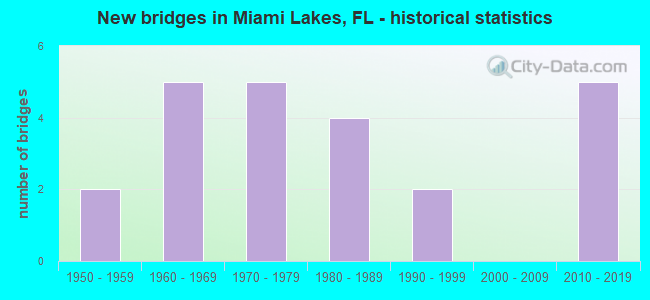
- New bridges - historical statistics
- 21950-1959
- 51960-1969
- 51970-1979
- 41980-1989
- 21990-1999
- 52010-2019

- Reconstructed bridges - Historical Statistics
- 21970-1979
- 21980-1989
- 21990-1999
- 22000-2009


- Bridge Condition - Deck
- 7.7%Excellent
- 7.7%Very good
- 76.9%Good
- 7.7%Fair

- Bridge Condition - Superstructure
- 7.7%Excellent
- 7.7%Very good
- 69.2%Good
- 15.4%Fair

- Bridge Condition - Substructure
- 15.4%Excellent
- 7.7%Very good
- 76.9%Good

- Bridge Condition - Channel
- 50.0%Excellent
- 16.7%Very good
- 33.3%Good
Find on map >> Show street view
Structure Number: 870102, Location: 0.3 MI N OF NW 154 ST (Lat: 25.918453, Lng: -80.325278), Route carried "on" structure: State highway 826, Year Built: 1959, Year Reconstructed: 1997, Status: Open, Structure Length: 2.74m (8.99ft), Average Daily Traffic: 56,500 (year 2020), Truck Traffic: 6%, Average Future Daily Traffic: 98,028 (year 2042), Design Load: HL 93, Features Intersected: CANAL C-8
Minimum Vertical Clearance: 30+ m (98+ ft), Kilometerpoint: 26.891, Lanes on structure: 3, Base Highway Network: Yes, Owner: State Highway Agency, Approaching Roadway Width: 17.1m (56.1ft), Material/Design: Concrete, Design/Construction: Slab, Number Of Spans In Main Unit: 3, Length of Maximum Span: 9.1m (29.9ft), Curb-To-Curb Width: 17.1m (56.1ft), Out-to-Out Width: 18.0m (59.1ft)
Condition: Deck: Good, Superstructure: Good, Substructure: Good, Channel: Excellent, Operating Rating: 33.0 metric tons, Method Used To Determine Operating Rating: Load and Resistance Factor (LRFR), Inventory Rating: 25.5 metric tons, Method Used To Determine Inventory Rating: Load and Resistance Factor (LRFR), Structural Evaluation: Equal to present minimum criteria, Deck Geometry: Equal to present minimum criteria, Waterway Adequacy: Equal to present desirable criteria, Approach Roadway Alignment: Equal to present desirable criteria, Designated Inspection Frequency: Every 24 months, Underwater Inspection Frequency: Every 24 months, Inspection Date: May 2021, Underwater Inspection Date: May 2021, Deck Structure Type: Concrete Cast-file-Place
Find on map >> Show street view
Structure Number: 870252, Location: 0.3MI N OF NW 154 ST (Lat: 25.918478, Lng: -80.325097), Route carried "on" structure: State highway 826, Year Built: 1959, Year Reconstructed: 1997, Status: Open, Structure Length: 2.74m (8.99ft), Average Daily Traffic: 56,500 (year 2020), Truck Traffic: 6%, Average Future Daily Traffic: 98,028 (year 2042), Design Load: HS 20, Features Intersected: CANAL C-8
Minimum Vertical Clearance: 30+ m (98+ ft), Kilometerpoint: 26.891, Lanes on structure: 4, Base Highway Network: Yes, Owner: State Highway Agency, Approaching Roadway Width: 19.7m (64.6ft), Material/Design: Concrete, Design/Construction: Slab, Number Of Spans In Main Unit: 3, Length of Maximum Span: 9.1m (29.9ft), Curb-To-Curb Width: 19.7m (64.6ft), Out-to-Out Width: 20.6m (67.6ft)
Condition: Deck: Good, Superstructure: Good, Substructure: Good, Channel: Excellent, Operating Rating: 67.8 metric tons, Method Used To Determine Operating Rating: Load Factor (LF), Inventory Rating: 40.6 metric tons, Method Used To Determine Inventory Rating: Load Factor (LF), Structural Evaluation: Better than present minimum criteria, Deck Geometry: Equal to present minimum criteria, Waterway Adequacy: Equal to present desirable criteria, Approach Roadway Alignment: Equal to present desirable criteria, Designated Inspection Frequency: Every 24 months, Underwater Inspection Frequency: Every 24 months, Inspection Date: May 2021, Underwater Inspection Date: May 2021, Deck Structure Type: Concrete Cast-file-Place
Find on map >> Show street view
Structure Number: 870253, Location: 3MI W OF SR-817 (Lat: 25.925081, Lng: -80.293186), Route carried "on" structure: State highway 826, Year Built: 1963, Year Reconstructed: 1978, Status: Open, Structure Length: 5.12m (16.80ft), Average Daily Traffic: 150,000 (year 2022), Truck Traffic: 6%, Average Future Daily Traffic: 260,250 (year 2042), Design Load: HS 20, Features Intersected: SR-823 (NW 57TH AVE.)
Minimum Vertical Clearance: 30+ m (98+ ft), Kilometerpoint: 30.513, Lanes on structure: 6, Lanes under structure: 8, Base Highway Network: Yes, Owner: State Highway Agency, Approaching Roadway Width: 32.1m (105.3ft), Skew: 30 degrees, Material/Design: Prestressed concrete, Design/Construction: Stringer/Multi-beam, Number Of Spans In Main Unit: 4, Length of Maximum Span: 15.8m (51.8ft), Curb-To-Curb Width: 32.1m (105.3ft), Out-to-Out Width: 33.9m (111.2ft)
Condition: Deck: Good, Superstructure: Fair, Substructure: Good, Operating Rating: 49.8 metric tons, Method Used To Determine Operating Rating: Load and Resistance Factor (LRFR), Inventory Rating: 32.7 metric tons, Method Used To Determine Inventory Rating: Load and Resistance Factor (LRFR), Structural Evaluation: Somewhat better than minimum adequacy, Deck Geometry: Superior to present desirable criteria, Underclear: High priority of corrective action, Approach Roadway Alignment: Equal to present desirable criteria, Designated Inspection Frequency: Every 24 months, Inspection Date: Febuary 2022, Deck Structure Type: Concrete Cast-file-Place
Find on map >> Show street view
Structure Number: 870259, Location: 1MI W OF SR-823 (57 AVE) (Lat: 25.924775, Lng: -80.309392), Route carried "on" structure: State highway 826, Year Built: 1967, Year Reconstructed: 1978, Status: Open, Structure Length: 5.43m (17.81ft), Average Daily Traffic: 133,041 (year 2022), Truck Traffic: 7%, Average Future Daily Traffic: 230,826 (year 2042), Design Load: HS 20, Features Intersected: NW 67TH AVE (LUDLAM RD.)
Minimum Vertical Clearance: 30+ m (98+ ft), Kilometerpoint: 28.888, Lanes on structure: 6, Lanes under structure: 8, Base Highway Network: Yes, Owner: State Highway Agency, Approaching Roadway Width: 31.8m (104.3ft), Skew: 30 degrees, Material/Design: Prestressed concrete, Design/Construction: Stringer/Multi-beam, Number Of Spans In Main Unit: 4, Length of Maximum Span: 16.2m (53.1ft), Curb-To-Curb Width: 31.8m (104.3ft), Out-to-Out Width: 33.6m (110.2ft)
Condition: Deck: Good, Superstructure: Good, Substructure: Good, Operating Rating: 61.2 metric tons, Method Used To Determine Operating Rating: Load Factor (LF), Inventory Rating: 38.8 metric tons, Method Used To Determine Inventory Rating: Load Factor (LF), Structural Evaluation: Better than present minimum criteria, Deck Geometry: Superior to present desirable criteria, Underclear: High priority of corrective action, Approach Roadway Alignment: Equal to present desirable criteria, Designated Inspection Frequency: Every 24 months, Inspection Date: Febuary 2022, Deck Structure Type: Concrete Cast-file-Place
Find on map >> Show street view
Structure Number: 870468, Location: 1 MI N OF SR-924 (Lat: 25.913347, Lng: -80.324981), Route carried "on" structure: State highway 826, Year Built: 1974, Year Reconstructed: 1985, Status: Open, Structure Length: 5.49m (18.01ft), Average Daily Traffic: 135,500 (year 2020), Truck Traffic: 6%, Average Future Daily Traffic: 235,093 (year 2042), Design Load: HL 93, Features Intersected: NW 154TH ST
Minimum Vertical Clearance: 30+ m (98+ ft), Kilometerpoint: 26.305, Lanes on structure: 7, Lanes under structure: 6, Base Highway Network: Yes, Owner: State Highway Agency, Approaching Roadway Width: 40.2m (131.9ft), Skew: 30 degrees, Material/Design: Prestressed concrete, Design/Construction: Stringer/Multi-beam, Number Of Spans In Main Unit: 2, Length of Maximum Span: 27.4m (89.9ft), Curb-To-Curb Width: 40.2m (131.9ft), Out-to-Out Width: 42.0m (137.8ft)
Condition: Deck: Good, Superstructure: Very good, Substructure: Good, Operating Rating: 61.1 metric tons, Method Used To Determine Operating Rating: Load and Resistance Factor (LRFR), Inventory Rating: 38.8 metric tons, Method Used To Determine Inventory Rating: Load and Resistance Factor (LRFR), Structural Evaluation: Better than present minimum criteria, Deck Geometry: Superior to present desirable criteria, Underclear: Somewhat better than minimum adequacy, Approach Roadway Alignment: Equal to present desirable criteria, Designated Inspection Frequency: Every 24 months, Inspection Date: May 2021, Deck Structure Type: Concrete Cast-file-Place
Find on map >> Show street view
Structure Number: 870538, Location: 0.1 MI W OF SR-826 (Lat: 25.913403, Lng: -80.327192), Route carried "on" structure: Alternate City street 826, Year Built: 1974, Year Reconstructed: 2007, Status: Open, Structure Length: 0.70m (2.30ft), Average Daily Traffic: 12,250 (year 2020), Truck Traffic: 4%, Average Future Daily Traffic: 21,254 (year 2042), Design Load: HL 93, Features Intersected: CANAL C-8, Facility Carried by Structure: NW 154 ST - W.B.
Minimum Vertical Clearance: 30+ m (98+ ft), Kilometerpoint: 1.376, Lanes on structure: 3, Owner: State Highway Agency, Approaching Roadway Width: 12.0m (39.4ft), Material/Design: Concrete, Design/Construction: Slab, Number Of Spans In Main Unit: 1, Length of Maximum Span: 7.0m (23.0ft), Curb or Sidewalk Widths: Left: 2.0m (6.6ft), Right: 0.0m, Curb-To-Curb Width: 12.0m (39.4ft), Out-to-Out Width: 15.0m (49.2ft)
Condition: Deck: Good, Superstructure: Good, Substructure: Good, Channel: Good, Operating Rating: 42.8 metric tons, Method Used To Determine Operating Rating: Load and Resistance Factor (LRFR), Inventory Rating: 33.0 metric tons, Method Used To Determine Inventory Rating: Load and Resistance Factor (LRFR), Structural Evaluation: Better than present minimum criteria, Deck Geometry: Meets minimum limits, Waterway Adequacy: Equal to present desirable criteria, Approach Roadway Alignment: Equal to present desirable criteria, Designated Inspection Frequency: Every 24 months, Underwater Inspection Frequency: Every 24 months, Inspection Date: March 2021, Underwater Inspection Date: March 2021, Deck Structure Type: Concrete Cast-file-Place, Wearing Surface/Protective System: Wearing Surface: Bituminous
Find on map >> Show street view
Structure Number: 870539, Location: 0.1 M W OF SR-826 (Lat: 25.913200, Lng: -80.327192), Route carried "on" structure: Alternate City street 826, Year Built: 1974, Year Reconstructed: 2007, Status: Open, Structure Length: 0.70m (2.30ft), Average Daily Traffic: 12,250 (year 2020), Truck Traffic: 4%, Average Future Daily Traffic: 21,254 (year 2042), Design Load: HL 93, Features Intersected: CANAL C-8, Facility Carried by Structure: NW 154 ST - E.B.
Minimum Vertical Clearance: 30+ m (98+ ft), Kilometerpoint: 1.376, Lanes on structure: 3, Owner: State Highway Agency, Approaching Roadway Width: 12.0m (39.4ft), Material/Design: Concrete, Design/Construction: Slab, Number Of Spans In Main Unit: 1, Length of Maximum Span: 7.0m (23.0ft), Curb or Sidewalk Widths: Left: 0.0m, Right: 2.0m (6.6ft), Curb-To-Curb Width: 12.0m (39.4ft), Out-to-Out Width: 15.0m (49.2ft)
Condition: Deck: Good, Superstructure: Good, Substructure: Good, Channel: Excellent, Operating Rating: 42.8 metric tons, Method Used To Determine Operating Rating: Load and Resistance Factor (LRFR), Inventory Rating: 33.0 metric tons, Method Used To Determine Inventory Rating: Load and Resistance Factor (LRFR), Structural Evaluation: Better than present minimum criteria, Deck Geometry: Meets minimum limits, Waterway Adequacy: Equal to present desirable criteria, Approach Roadway Alignment: Equal to present desirable criteria, Designated Inspection Frequency: Every 24 months, Underwater Inspection Frequency: Every 24 months, Inspection Date: March 2021, Underwater Inspection Date: March 2021, Deck Structure Type: Concrete Cast-file-Place, Wearing Surface/Protective System: Wearing Surface: Bituminous
Find on map >> Show street view
Structure Number: 870604, Location: 1.4MI W of PALMETTO EXPWY (Lat: 25.899328, Lng: -80.347014), Route carried "on" structure: Ramp City street 75, Year Built: 1985, Status: Open, Structure Length: 15.12m (49.61ft), Average Daily Traffic: 16,000 (year 2020), Truck Traffic: 13%, Average Future Daily Traffic: 27,760 (year 2042), Design Load: HS 20, Features Intersected: I-75, Facility Carried by Structure: RAMP TO NW 138TH
Minimum Vertical Clearance: 30+ m (98+ ft), Kilometerpoint: 0.481, Lanes on structure: 2, Lanes under structure: 10, Owner: State Highway Agency, Approaching Roadway Width: 12.2m (40.0ft), Skew: 5 degrees, Material/Design: Steel continuous, Design/Construction: Stringer/Multi-beam, Number Of Spans In Main Unit: 5, Length of Maximum Span: 45.4m (149.0ft), Curb-To-Curb Width: 12.2m (40.0ft), Out-to-Out Width: 13.1m (43.0ft)
Condition: Deck: Good, Superstructure: Good, Substructure: Good, Operating Rating: 41.5 metric tons, Method Used To Determine Operating Rating: Load Factor (LF), Inventory Rating: 24.9 metric tons, Method Used To Determine Inventory Rating: Load Factor (LF), Structural Evaluation: Equal to present minimum criteria, Deck Geometry: Superior to present desirable criteria, Underclear: Somewhat better than minimum adequacy, Approach Roadway Alignment: Equal to present minimum criteria, Designated Inspection Frequency: Every 24 months, Inspection Date: September 2020, Deck Structure Type: Concrete Cast-file-Place
Find on map >> Show street view
Structure Number: 870609, Location: NW 57 Ave. & NW 153 St. (Lat: 25.913433, Lng: -80.292686), Route carried "on" structure: State highway 823, Year Built: 1960, Year Reconstructed: 1994, Status: Open, Structure Length: 2.74m (8.99ft), Average Daily Traffic: 46,500 (year 2020), Truck Traffic: 6%, Average Future Daily Traffic: 80,678 (year 2042), Design Load: HS 20, Features Intersected: BISCAYNE CANAL C-8
Minimum Vertical Clearance: 30+ m (98+ ft), Kilometerpoint: 9.275, Lanes on structure: 6, Owner: State Highway Agency, Approaching Roadway Width: 26.2m (86.0ft), Skew: 20 degrees, Material/Design: Prestressed concrete, Design/Construction: Slab, Number Of Spans In Main Unit: 3, Length of Maximum Span: 9.1m (29.9ft), Curb or Sidewalk Widths: Left: 0.0m, Right: 2.0m (6.6ft), Curb-To-Curb Width: 26.2m (86.0ft), Out-to-Out Width: 29.2m (95.8ft)
Condition: Deck: Good, Superstructure: Good, Substructure: Good, Channel: Good, Operating Rating: 74.5 metric tons, Method Used To Determine Operating Rating: Load Factor (LF), Inventory Rating: 44.7 metric tons, Method Used To Determine Inventory Rating: Load Factor (LF), Structural Evaluation: Better than present minimum criteria, Deck Geometry: Equal to present minimum criteria, Waterway Adequacy: Better than present minimum criteria, Approach Roadway Alignment: Equal to present desirable criteria, Designated Inspection Frequency: Every 24 months, Underwater Inspection Frequency: Every 24 months, Inspection Date: August 2020, Underwater Inspection Date: August 2020, Deck Structure Type: Concrete Precast Panels, Wearing Surface/Protective System: Wearing Surface: Bituminous
Find on map >> Show street view
Structure Number: 870768, Location: 1 MILE N OF SR-924 (Lat: 25.913294, Lng: -80.325239), Route carried "on" structure: Ramp State highway 826, Year Built: 1997, Status: Open, Structure Length: 5.49m (18.01ft), Average Daily Traffic: 6,400 (year 2020), Truck Traffic: 3%, Average Future Daily Traffic: 11,104 (year 2042), Design Load: HS 20, Features Intersected: NW 154TH ST
Minimum Vertical Clearance: 30+ m (98+ ft), Kilometerpoint: 0.056, Lanes on structure: 1, Lanes under structure: 6, Owner: State Highway Agency, Approaching Roadway Width: 8.3m (27.2ft), Material/Design: Prestressed concrete, Design/Construction: Stringer/Multi-beam, Number Of Spans In Main Unit: 2, Length of Maximum Span: 27.5m (90.2ft), Curb-To-Curb Width: 8.3m (27.2ft), Out-to-Out Width: 9.1m (29.9ft)
Condition: Deck: Very good, Superstructure: Good, Substructure: Very good, Inventory Rating: 69.9 metric tons, Method Used To Determine Inventory Rating: Load Factor (LF), Structural Evaluation: Better than present minimum criteria, Deck Geometry: Superior to present desirable criteria, Underclear: Somewhat better than minimum adequacy, Approach Roadway Alignment: Equal to present minimum criteria, Designated Inspection Frequency: Every 24 months, Inspection Date: May 2021, Deck Structure Type: Concrete Cast-file-Place
Find on map >> Show street view
Structure Number: 870769, Location: 0.3 MI N OF NW 154TH ST (Lat: 25.918461, Lng: -80.324817), Route carried "on" structure: ServiceState highway 826, Year Built: 1971, Status: Open, Structure Length: 2.79m (9.15ft), Average Daily Traffic: 1,465 (year 2021), Truck Traffic: 2%, Average Future Daily Traffic: 2,542 (year 2041), Design Load: HS 20, Features Intersected: BISCAYNE CANAL C-8, Facility Carried by Structure: FRONTG RD/NW 167EB
Minimum Vertical Clearance: 30+ m (98+ ft), Kilometerpoint: 0.547, Lanes on structure: 2, Owner: State Highway Agency, Approaching Roadway Width: 9.8m (32.2ft), Material/Design: Prestressed concrete, Design/Construction: Slab, Number Of Spans In Main Unit: 3, Length of Maximum Span: 9.3m (30.5ft), Curb-To-Curb Width: 9.8m (32.2ft), Out-to-Out Width: 10.4m (34.1ft)
Condition: Deck: Fair, Superstructure: Fair, Substructure: Good, Channel: Very good, Operating Rating: 61.4 metric tons, Method Used To Determine Operating Rating: Load Factor (LF), Inventory Rating: 36.8 metric tons, Method Used To Determine Inventory Rating: Load Factor (LF), Structural Evaluation: Somewhat better than minimum adequacy, Deck Geometry: Meets minimum limits, Waterway Adequacy: Better than present minimum criteria, Approach Roadway Alignment: Equal to present desirable criteria, Designated Inspection Frequency: Every 24 months, Underwater Inspection Frequency: Every 24 months, Inspection Date: October 2021, Underwater Inspection Date: October 2021, Deck Structure Type: Concrete Precast Panels, Wearing Surface/Protective System: Wearing Surface: Bituminous
Find on map >> Show street view
Structure Number: 871101, Location: I-75 & SR 826 Interchange (Lat: 25.899747, Lng: -80.326817), Route carried "on" structure: State highway 924, Year Built: 2016, Status: Open, Structure Length: 8.96m (29.40ft), Average Daily Traffic: 70,250 (year 2020), Truck Traffic: 8%, Average Future Daily Traffic: 121,884 (year 2042), Design Load: HL 93, Features Intersected: SR 826 Express Lanes
Minimum Vertical Clearance: 4.99m (16.37ft), Kilometerpoint: 8.219, Lanes on structure: 3, Lanes under structure: 2, Base Highway Network: Yes, Toll: On toll road, Owner: State Highway Agency, Approaching Roadway Width: 17.1m (56.1ft), Skew: 5 degrees, Material/Design: Prestressed concrete, Design/Construction: Stringer/Multi-beam, Number Of Spans In Main Unit: 2, Length of Maximum Span: 52.7m (172.9ft), Curb-To-Curb Width: 17.1m (56.1ft), Out-to-Out Width: 18.0m (59.1ft)
Condition: Deck: Excellent, Superstructure: Excellent, Substructure: Excellent, Operating Rating: 53.9 metric tons, Method Used To Determine Operating Rating: Load and Resistance Factor (LRFR), Inventory Rating: 48.4 metric tons, Method Used To Determine Inventory Rating: Load and Resistance Factor (LRFR), Structural Evaluation: Superior to present desirable criteria, Deck Geometry: Somewhat better than minimum adequacy, Underclear: Somewhat better than minimum adequacy, Approach Roadway Alignment: Equal to present desirable criteria, Designated Inspection Frequency: Every 24 months, Inspection Date: July 2020, Deck Structure Type: Concrete Cast-file-Place, Wearing Surface/Protective System: Wearing Surface: Monolithic Concrete
Find on map >> Show street view
Structure Number: 871104, Location: I-75 & FL TPK Interchang (Lat: 25.948583, Lng: -80.351353), Route carried "on" structure: Interstate 75, Year Built: 2016, Status: Open, Structure Length: 9.20m (30.18ft), Average Daily Traffic: 5,300 (year 2020), Truck Traffic: 12%, Average Future Daily Traffic: 9,196 (year 2042), Design Load: HL 93, Features Intersected: SR 821 FLTurnpike
Minimum Vertical Clearance: 30+ m (98+ ft), Kilometerpoint: 0.847, Lanes on structure: 4, Lanes under structure: 7, Base Highway Network: Yes, Toll: On toll road, Owner: State Highway Agency, Approaching Roadway Width: 24.4m (80.1ft), Skew: 34 degrees, Material/Design: Prestressed concrete, Design/Construction: Stringer/Multi-beam, Number Of Spans In Main Unit: 3, Length of Maximum Span: 36.6m (120.1ft), Curb-To-Curb Width: 24.4m (80.1ft), Out-to-Out Width: 27.4m (89.9ft)
Condition: Deck: Good, Superstructure: Good, Substructure: Excellent, Operating Rating: 58.8 metric tons, Method Used To Determine Operating Rating: Load and Resistance Factor (LRFR), Inventory Rating: 43.1 metric tons, Method Used To Determine Inventory Rating: Load and Resistance Factor (LRFR), Structural Evaluation: Better than present minimum criteria, Deck Geometry: Superior to present desirable criteria, Underclear: Meets minimum limits, Approach Roadway Alignment: Equal to present desirable criteria, Designated Inspection Frequency: Every 24 months, Inspection Date: June 2020, Deck Structure Type: Concrete Cast-file-Place, Wearing Surface/Protective System: Wearing Surface: Monolithic Concrete
Find on map >> Show street view
Structure Number: 870253, Location: 3MI W OF SR-817 (Lat: 25.925081, Lng: -80.293186), Route carried "under" structure: City street 823, Year Built: 1963, Structure Length: 0. m, Average Daily Traffic: 47,500 (year 2022), Truck Traffic: 6%, Features Intersected: SR-823 (NW 57TH AVE.), Facility Carried by Structure: SR-826
Minimum Vertical Clearance: 4.42m (14.50ft), Kilometerpoint: 10.557, Lanes on structure: 6, Lanes under structure: 8, Material/Design: Prestressed concrete, Design/Construction: Stringer/Multi-beam, Length of Maximum Span: 15.8m (51.8ft)
Find on map >> Show street view
Structure Number: 870259, Location: 1MI W OF SR-823 (57 AVE) (Lat: 25.924775, Lng: -80.309392), Route carried "under" structure: City street , Year Built: 1967, Structure Length: 0. m, Average Daily Traffic: 14,400 (year 2022), Truck Traffic: 6%, Features Intersected: NW 67TH AVE (LUDLAM RD.), Facility Carried by Structure: SR-826
Minimum Vertical Clearance: 4.24m (13.91ft), Kilometerpoint: 0.000, Lanes on structure: 6, Lanes under structure: 8, Material/Design: Prestressed concrete, Design/Construction: Stringer/Multi-beam, Length of Maximum Span: 16.2m (53.1ft)
Find on map >> Show street view
Structure Number: 870468, Location: 1 MI N OF SR-924 (Lat: 25.913347, Lng: -80.324981), Route carried "under" structure: City street , Year Built: 1974, Structure Length: 0. m, Average Daily Traffic: 24,500 (year 2020), Truck Traffic: 4%, Features Intersected: NW 154TH ST, Facility Carried by Structure: SR-826
Minimum Vertical Clearance: 4.94m (16.21ft), Kilometerpoint: 1.592, Lanes on structure: 7, Lanes under structure: 6, Material/Design: Prestressed concrete, Design/Construction: Stringer/Multi-beam, Length of Maximum Span: 27.4m (89.9ft)
Find on map >> Show street view
Structure Number: 870604, Location: 1.4MI W of PALMETTO EXPWY (Lat: 25.899328, Lng: -80.347014), Route carried "under" structure: ServiceInterstate 75, Year Built: 1985, Structure Length: 0. m, Average Daily Traffic: 5,500 (year 2019), Truck Traffic: 11%, Features Intersected: I-75, Facility Carried by Structure: RAMP TO NW 138TH
Minimum Vertical Clearance: 5.18m (16.99ft), Kilometerpoint: 6.408, Lanes on structure: 2, Lanes under structure: 1, Toll: On toll road, Material/Design: Steel continuous, Design/Construction: Stringer/Multi-beam, Length of Maximum Span: 45.4m (149.0ft)
Find on map >> Show street view
Structure Number: 870604, Location: 1.4MI W of PALMETTO EXPWY (Lat: 25.899328, Lng: -80.347014), Route carried "under" structure: ServiceInterstate 75, Year Built: 1985, Structure Length: 0. m, Average Daily Traffic: 5,500 (year 2019), Truck Traffic: 11%, Features Intersected: I-75, Facility Carried by Structure: RAMP TO NW 138TH
Minimum Vertical Clearance: 6.68m (21.92ft), Kilometerpoint: 2.855, Lanes on structure: 2, Lanes under structure: 1, Toll: On toll road, Material/Design: Steel continuous, Design/Construction: Stringer/Multi-beam, Length of Maximum Span: 45.4m (149.0ft)
Find on map >> Show street view
Structure Number: 870604, Location: 1.4MI W of PALMETTO EXPWY (Lat: 25.899328, Lng: -80.347014), Route carried "under" structure: Interstate 75, Year Built: 1985, Structure Length: 0. m, Average Daily Traffic: 140,000 (year 2020), Truck Traffic: 8%, Features Intersected: I-75, Facility Carried by Structure: RAMP TO NW 138TH
Minimum Vertical Clearance: 4.95m (16.24ft), Kilometerpoint: 2.343, Lanes on structure: 2, Lanes under structure: 8, Material/Design: Steel continuous, Design/Construction: Stringer/Multi-beam, Length of Maximum Span: 45.4m (149.0ft)
Find on map >> Show street view
Structure Number: 870768, Location: 1 MILE N OF SR-924 (Lat: 25.913294, Lng: -80.325239), Route carried "under" structure: City street , Year Built: 1997, Structure Length: 0. m, Average Daily Traffic: 24,500 (year 2020), Truck Traffic: 4%, Features Intersected: NW 154TH ST, Facility Carried by Structure: SR-826 SB OFF RAMP
Minimum Vertical Clearance: 5.03m (16.50ft), Kilometerpoint: 1.580, Lanes on structure: 1, Lanes under structure: 6, Material/Design: Prestressed concrete, Design/Construction: Stringer/Multi-beam, Length of Maximum Span: 27.5m (90.2ft)
Find on map >> Show street view
Structure Number: 8711, Location: I-75 & SR 826 Interchange (Lat: 25.899656, Lng: -80.326367), Route carried "under" structure: Ramp State highway 826, Year Built: 2016, Structure Length: 0. m, Average Daily Traffic: 9,300 (year 2016), Features Intersected: SR 826 Express Lanes, Facility Carried by Structure: EB SR 924 On-ramp
Minimum Vertical Clearance: 5.03m (16.50ft), Kilometerpoint: 24.768, Lanes on structure: 1, Lanes under structure: 2, Toll: On toll road, Material/Design: Prestressed concrete, Design/Construction: Stringer/Multi-beam, Length of Maximum Span: 23.2m (76.1ft)
Find on map >> Show street view
Structure Number: 871101, Location: I-75 & SR 826 Interchange (Lat: 25.899747, Lng: -80.326817), Route carried "under" structure: Ramp State highway 826, Year Built: 2016, Structure Length: 0. m, Average Daily Traffic: 9,300 (year 2016), Features Intersected: SR 826 Express Lanes, Facility Carried by Structure: EB SR 924
Minimum Vertical Clearance: 5.03m (16.50ft), Kilometerpoint: 24.769, Lanes on structure: 3, Lanes under structure: 2, Toll: On toll road, Material/Design: Prestressed concrete, Design/Construction: Stringer/Multi-beam, Length of Maximum Span: 52.7m (172.9ft)
Find on map >> Show street view
Structure Number: 871104, Location: I-75 & FL TPK Interchang (Lat: 25.948583, Lng: -80.351353), Route carried "under" structure: State highway 821, Year Built: 2016, Structure Length: 0. m, Average Daily Traffic: 59,200 (year 2019), Truck Traffic: 7%, Features Intersected: SR 821 FLTurnpike, Facility Carried by Structure: I-75 Express Lanes
Minimum Vertical Clearance: 5.11m (16.77ft), Kilometerpoint: 63.423, Lanes on structure: 4, Lanes under structure: 5, Toll: On toll road, Material/Design: Prestressed concrete, Design/Construction: Stringer/Multi-beam, Length of Maximum Span: 36.6m (120.1ft)