Bridge Statistics for Mercerville-Hamilton Square, New Jersey (NJ)
Condition, Traffic, Stress, Structural Evaluation, Project Costs
- National Bridge Inventory (NBI) Statistics
- 18Number of bridges
- 115ft / 35.4mTotal length
- $865,000Total costs
- 420,357Total average daily traffic
- 32,079Total average daily truck traffic
- National Bridge Inventory (NBI) Registered Bridges for Mercerville-Hamilton Square
- No street view available for this location
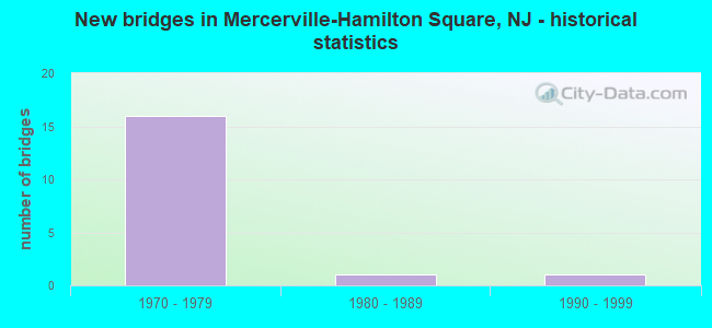
- New bridges - historical statistics
- 161970-1979
- 11980-1989
- 11990-1999
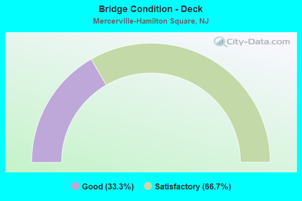
- Bridge Condition - Deck
- 33.3%Good
- 66.7%Satisfactory
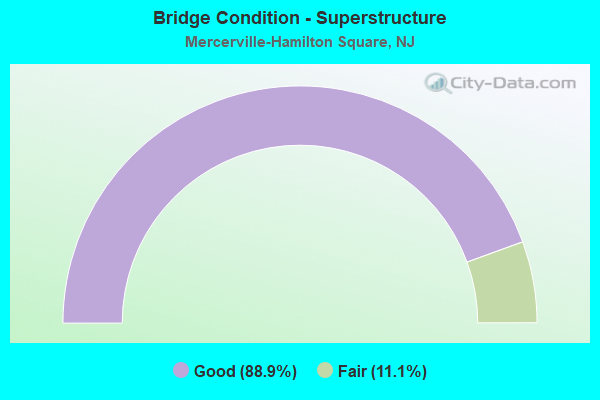
- Bridge Condition - Superstructure
- 88.9%Good
- 11.1%Fair
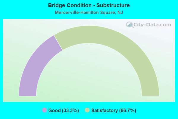
- Bridge Condition - Substructure
- 33.3%Good
- 66.7%Satisfactory
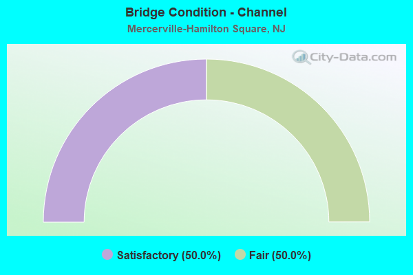
- Bridge Condition - Channel
- 50.0%Satisfactory
- 50.0%Fair
Find on map >> Show street view
Structure Number: 1100024, Location: 0.4 mile South of CR 535 (Lat: 40.243869, Lng: -74.659539), Route carried "on" structure: City street , Year Built: 1995, Status: Open, Structure Length: 1.40m (4.59ft), Average Daily Traffic: 6,480 (year 2021), Truck Traffic: 4%, Average Future Daily Traffic: 7,905 (year 2041), Design Load: HS 25 or greater, Features Intersected: MIRY RUN, Facility Carried by Structure: HUGHES DRIVE
Minimum Vertical Clearance: 30+ m (98+ ft), Kilometerpoint: 1.127, Lanes on structure: 2, Owner: County Highway Agency, Approaching Roadway Width: 15.2m (49.9ft), Skew: 1 degrees, Material/Design: Prestressed concrete, Design/Construction: Box Beam or Girders - Multiple, Number Of Spans In Main Unit: 1, Length of Maximum Span: 13.1m (43.0ft), Curb or Sidewalk Widths: Left: 1.5m (4.9ft), Right: 1.5m (4.9ft), Curb-To-Curb Width: 15.2m (49.9ft), Out-to-Out Width: 19.0m (62.3ft)
Condition: Deck: Satisfactory, Superstructure: Good, Substructure: Good, Channel: Fair, Inventory Rating: 62.6 metric tons, Method Used To Determine Inventory Rating: Load Factor (LF), Structural Evaluation: Better than present minimum criteria, Deck Geometry: Superior to present desirable criteria, Waterway Adequacy: Equal to present desirable criteria, Approach Roadway Alignment: Equal to present desirable criteria, Designated Inspection Frequency: Every 24 months, Inspection Date: Febuary 2021, Deck Structure Type: Concrete Cast-file-Place, Wearing Surface/Protective System: Deck Protection: Epoxy Coated Reinforcing
Find on map >> Show street view
Structure Number: 1137169, Location: 0.4 MI SOUTH OF EXIT 63 (Lat: 40.227200, Lng: -74.699000), Route carried "on" structure: City street , Year Built: 1975, Status: Open, Structure Length: 6.52m (21.39ft), Average Daily Traffic: 4,505 (year 2021), Truck Traffic: 4%, Average Future Daily Traffic: 5,496 (year 2041), Design Load: HS 20+Mod, Features Intersected: I-295, Facility Carried by Structure: KLOCKNER ROAD
Minimum Vertical Clearance: 30+ m (98+ ft), Kilometerpoint: 3.750, Lanes on structure: 2, Lanes under structure: 6, Owner: State Highway Agency, Approaching Roadway Width: 12.2m (40.0ft), Skew: 1 degrees, Material/Design: Steel, Design/Construction: Stringer/Multi-beam, Number Of Spans In Main Unit: 2, Length of Maximum Span: 31.7m (104.0ft), Curb or Sidewalk Widths: Left: 1.8m (5.9ft), Right: 1.8m (5.9ft), Curb-To-Curb Width: 12.2m (40.0ft), Out-to-Out Width: 16.6m (54.5ft)
Condition: Deck: Satisfactory, Superstructure: Fair, Substructure: Satisfactory, Operating Rating: 80.7 metric tons, Method Used To Determine Operating Rating: Load Factor (LF), Inventory Rating: 48.1 metric tons, Method Used To Determine Inventory Rating: Load Factor (LF), Structural Evaluation: Somewhat better than minimum adequacy, Deck Geometry: Equal to present minimum criteria, Underclear: High priority of corrective action, Approach Roadway Alignment: Equal to present desirable criteria, Length Of Structure Improvement: 6.52m (21.39ft), Designated Inspection Frequency: Every 24 months, Inspection Date: August 2021, Bridge Improvement Cost: $669,000, Total Project Cost: $865,000 ( Estimate for 2021), Deck Structure Type: Concrete Cast-file-Place, Wearing Surface/Protective System: Wearing Surface: Monolithic Concrete
Find on map >> Show street view
Structure Number: 1137171, Location: 3.7 MI SOUTH OF RT 1 (Lat: 40.232339, Lng: -74.700050), Route carried "on" structure: Interstate 295, Year Built: 1975, Status: Open, Structure Length: 3.35m (10.99ft), Average Daily Traffic: 36,437 (year 2020), Truck Traffic: 9%, Average Future Daily Traffic: 44,500 (year 2040), Design Load: HS 20, Features Intersected: HAMILTON AVE. (CT.RT606)
Minimum Vertical Clearance: 30+ m (98+ ft), Kilometerpoint: 102.885, Lanes on structure: 5, Lanes under structure: 2, Base Highway Network: Yes, Owner: State Highway Agency, Approaching Roadway Width: 25.0m (82.0ft), Skew: 31 degrees, Material/Design: Steel, Design/Construction: Stringer/Multi-beam, Number Of Spans In Main Unit: 1, Length of Maximum Span: 32.3m (106.0ft), Curb or Sidewalk Widths: Left: 0.0m, Right: 0.8m (2.6ft), Curb-To-Curb Width: 26.6m (87.3ft), Out-to-Out Width: 30.1m (98.8ft)
Condition: Deck: Satisfactory, Superstructure: Good, Substructure: Satisfactory, Operating Rating: 63.5 metric tons, Method Used To Determine Operating Rating: Load Factor (LF), Inventory Rating: 38.1 metric tons, Method Used To Determine Inventory Rating: Load Factor (LF), Structural Evaluation: Equal to present minimum criteria, Deck Geometry: Superior to present desirable criteria, Underclear: Equal to present minimum criteria, Approach Roadway Alignment: Better than present minimum criteria, Designated Inspection Frequency: Every 24 months, Inspection Date: August 2020, Deck Structure Type: Concrete Cast-file-Place, Wearing Surface/Protective System: Wearing Surface: Monolithic Concrete
Find on map >> Show street view
Structure Number: 1137172, Location: 3.7 MI S. OF US 1 (Lat: 40.232389, Lng: -74.700531), Route carried "on" structure: Interstate 295, Year Built: 1975, Status: Open, Structure Length: 3.35m (10.99ft), Average Daily Traffic: 64,025 (year 2020), Truck Traffic: 9%, Average Future Daily Traffic: 90,389 (year 2040), Design Load: HS 20+Mod, Features Intersected: HAMILTON AVENUE (CR 606)
Minimum Vertical Clearance: 30+ m (98+ ft), Kilometerpoint: 102.885, Lanes on structure: 4, Lanes under structure: 2, Base Highway Network: Yes, Owner: State Highway Agency, Approaching Roadway Width: 19.5m (64.0ft), Skew: 1 degrees, Material/Design: Steel, Design/Construction: Stringer/Multi-beam, Number Of Spans In Main Unit: 1, Length of Maximum Span: 32.3m (106.0ft), Curb-To-Curb Width: 19.5m (64.0ft), Out-to-Out Width: 20.7m (67.9ft)
Condition: Deck: Satisfactory, Superstructure: Good, Substructure: Satisfactory, Operating Rating: 86.2 metric tons, Method Used To Determine Operating Rating: Load Factor (LF), Inventory Rating: 51.7 metric tons, Method Used To Determine Inventory Rating: Load Factor (LF), Structural Evaluation: Equal to present minimum criteria, Deck Geometry: Somewhat better than minimum adequacy, Underclear: Equal to present minimum criteria, Approach Roadway Alignment: Equal to present desirable criteria, Designated Inspection Frequency: Every 24 months, Inspection Date: August 2020, Deck Structure Type: Concrete Cast-file-Place, Wearing Surface/Protective System: Wearing Surface: Monolithic Concrete, Deck Protection: Epoxy Coated Reinforcing
Find on map >> Show street view
Structure Number: 1137173, Location: AT I-295 EXIT 63 (Lat: 40.232361, Lng: -74.700689), Route carried "on" structure: Ramp Interstate 295, Year Built: 1974, Status: Open, Structure Length: 3.26m (10.70ft), Average Daily Traffic: 13,609 (year 2020), Truck Traffic: 9%, Average Future Daily Traffic: 16,605 (year 2040), Design Load: HS 20+Mod, Features Intersected: HAMILTON AVE. (CR. 606), Facility Carried by Structure: RAMP "B"
Minimum Vertical Clearance: 30+ m (98+ ft), Kilometerpoint: 102.885, Lanes on structure: 1, Lanes under structure: 2, Owner: State Highway Agency, Approaching Roadway Width: 6.4m (21.0ft), Material/Design: Steel, Design/Construction: Stringer/Multi-beam, Number Of Spans In Main Unit: 1, Length of Maximum Span: 31.1m (102.0ft), Curb or Sidewalk Widths: Left: 1.1m (3.6ft), Right: 0.0m, Curb-To-Curb Width: 6.5m (21.3ft), Out-to-Out Width: 9.1m (29.9ft)
Condition: Deck: Good, Superstructure: Good, Substructure: Good, Inventory Rating: 68.0 metric tons, Method Used To Determine Inventory Rating: Load Factor (LF), Structural Evaluation: Better than present minimum criteria, Deck Geometry: Somewhat better than minimum adequacy, Underclear: Equal to present minimum criteria, Approach Roadway Alignment: Equal to present minimum criteria, Designated Inspection Frequency: Every 24 months, Inspection Date: July 2020, Deck Structure Type: Concrete Cast-file-Place, Wearing Surface/Protective System: Wearing Surface: Monolithic Concrete
Find on map >> Show street view
Structure Number: 1137174, Location: 3.6 MI SOUTH OF RT 1 (Lat: 40.233531, Lng: -74.700250), Route carried "on" structure: Interstate 295, Year Built: 1974, Status: Open, Structure Length: 4.33m (14.21ft), Average Daily Traffic: 30,916 (year 2021), Truck Traffic: 9%, Average Future Daily Traffic: 40,192 (year 2041), Design Load: HS 20+Mod, Features Intersected: NOTTINGHAM WAY (NJ 33)
Minimum Vertical Clearance: 30+ m (98+ ft), Kilometerpoint: 103.014, Lanes on structure: 5, Lanes under structure: 5, Base Highway Network: Yes, Owner: State Highway Agency, Approaching Roadway Width: 23.8m (78.1ft), Skew: 20 degrees, Material/Design: Steel, Design/Construction: Stringer/Multi-beam, Number Of Spans In Main Unit: 1, Length of Maximum Span: 42.1m (138.1ft), Curb or Sidewalk Widths: Left: 0.2m (0.7ft), Right: 0.8m (2.6ft), Curb-To-Curb Width: 23.8m (78.1ft), Out-to-Out Width: 27.7m (90.9ft)
Condition: Deck: Satisfactory, Superstructure: Good, Substructure: Satisfactory, Inventory Rating: 67.1 metric tons, Method Used To Determine Inventory Rating: Load Factor (LF), Structural Evaluation: Equal to present minimum criteria, Deck Geometry: Equal to present minimum criteria, Underclear: Equal to present minimum criteria, Approach Roadway Alignment: Equal to present desirable criteria, Designated Inspection Frequency: Every 24 months, Inspection Date: March 2021, Deck Structure Type: Concrete Cast-file-Place, Wearing Surface/Protective System: Wearing Surface: Monolithic Concrete
Find on map >> Show street view
Structure Number: 1137175, Location: 3.6 MI SOUTH OF RT 1 (Lat: 40.233489, Lng: -74.700739), Route carried "on" structure: Interstate 295, Year Built: 1974, Status: Open, Structure Length: 4.33m (14.21ft), Average Daily Traffic: 32,303 (year 2021), Truck Traffic: 9%, Average Future Daily Traffic: 38,764 (year 2041), Design Load: HS 20, Features Intersected: NOTTINGHAM WAY (NJ 33)
Minimum Vertical Clearance: 30+ m (98+ ft), Kilometerpoint: 103.014, Lanes on structure: 4, Lanes under structure: 5, Base Highway Network: Yes, Owner: State Highway Agency, Approaching Roadway Width: 23.2m (76.1ft), Material/Design: Steel, Design/Construction: Stringer/Multi-beam, Number Of Spans In Main Unit: 1, Length of Maximum Span: 42.1m (138.1ft), Curb or Sidewalk Widths: Left: 0.2m (0.7ft), Right: 0.2m (0.7ft), Curb-To-Curb Width: 21.8m (71.5ft), Out-to-Out Width: 23.8m (78.1ft)
Condition: Deck: Satisfactory, Superstructure: Good, Substructure: Good, Inventory Rating: 60.8 metric tons, Method Used To Determine Inventory Rating: Load Factor (LF), Structural Evaluation: Better than present minimum criteria, Deck Geometry: Better than present minimum criteria, Underclear: Equal to present minimum criteria, Approach Roadway Alignment: Equal to present desirable criteria, Designated Inspection Frequency: Every 24 months, Inspection Date: March 2021, Deck Structure Type: Concrete Cast-file-Place, Wearing Surface/Protective System: Wearing Surface: Monolithic Concrete
Find on map >> Show street view
Structure Number: 113815, Location: AT I-295 EXIT 64 (Lat: 40.242211, Lng: -74.701169), Route carried "on" structure: Interstate 295, Year Built: 1974, Status: Open, Structure Length: 4.15m (13.62ft), Average Daily Traffic: 34,370 (year 2020), Truck Traffic: 9%, Average Future Daily Traffic: 41,932 (year 2040), Design Load: HS 20, Features Intersected: EAST STATE ST EXTENSION
Minimum Vertical Clearance: 30.45m (99.90ft), Kilometerpoint: 103.980, Lanes on structure: 3, Lanes under structure: 3, Base Highway Network: Yes, Owner: State Highway Agency, Approaching Roadway Width: 16.7m (54.8ft), Skew: 2 degrees, Material/Design: Steel, Design/Construction: Stringer/Multi-beam, Number Of Spans In Main Unit: 1, Length of Maximum Span: 39.6m (129.9ft), Curb-To-Curb Width: 16.7m (54.8ft), Out-to-Out Width: 17.9m (58.7ft)
Condition: Deck: Good, Superstructure: Good, Substructure: Satisfactory, Inventory Rating: 56.2 metric tons, Method Used To Determine Inventory Rating: Load Factor (LF), Structural Evaluation: Equal to present minimum criteria, Deck Geometry: Equal to present minimum criteria, Underclear: Somewhat better than minimum adequacy, Approach Roadway Alignment: Better than present minimum criteria, Designated Inspection Frequency: Every 24 months, Inspection Date: July 2020, Deck Structure Type: Concrete Cast-file-Place, Wearing Surface/Protective System: Wearing Surface: Monolithic Concrete
Find on map >> Show street view
Structure Number: 1138151, Location: 3 MI SOUTH OF RT 1 (Lat: 40.243000, Lng: -74.701450), Route carried "on" structure: Interstate 295, Year Built: 1974, Status: Open, Structure Length: 4.08m (13.39ft), Average Daily Traffic: 32,970 (year 2021), Truck Traffic: 9%, Average Future Daily Traffic: 45,252 (year 2041), Design Load: HS 20+Mod, Features Intersected: E.STATE ST. (CO.RT 535)
Minimum Vertical Clearance: 30+ m (98+ ft), Kilometerpoint: 103.980, Lanes on structure: 4, Lanes under structure: 3, Base Highway Network: Yes, Owner: State Highway Agency, Approaching Roadway Width: 19.5m (64.0ft), Skew: 2 degrees, Material/Design: Steel, Design/Construction: Stringer/Multi-beam, Number Of Spans In Main Unit: 1, Length of Maximum Span: 39.6m (129.9ft), Curb or Sidewalk Widths: Left: 0.2m (0.7ft), Right: 0.2m (0.7ft), Curb-To-Curb Width: 19.7m (64.6ft), Out-to-Out Width: 20.9m (68.6ft)
Condition: Deck: Good, Superstructure: Good, Substructure: Satisfactory, Inventory Rating: 58.1 metric tons, Method Used To Determine Inventory Rating: Load Factor (LF), Structural Evaluation: Equal to present minimum criteria, Deck Geometry: Equal to present minimum criteria, Underclear: Equal to present minimum criteria, Approach Roadway Alignment: Equal to present desirable criteria, Designated Inspection Frequency: Every 24 months, Inspection Date: March 2021, Deck Structure Type: Concrete Cast-file-Place, Wearing Surface/Protective System: Wearing Surface: Monolithic Concrete
Find on map >> Show street view
Structure Number: 1164211, Location: 2.3 miles South of I-295 (Lat: 40.212919, Lng: -74.658931), Route carried "on" structure: City street , Year Built: 1983, Status: Open, Structure Length: 0.67m (2.20ft), Average Daily Traffic: 11,655 (year 2021), Truck Traffic: 3%, Average Future Daily Traffic: 14,220 (year 2041), Design Load: HS 20, Features Intersected: BRANCH OF POND RUN, Facility Carried by Structure: KLOCKNER ROAD
Minimum Vertical Clearance: 30+ m (98+ ft), Kilometerpoint: 7.532, Lanes on structure: 2, Owner: County Highway Agency, Approaching Roadway Width: 15.2m (49.9ft), Material/Design: Concrete, Design/Construction: Culvert, Number Of Spans In Main Unit: 1, Length of Maximum Span: 6.7m (22.0ft), Curb or Sidewalk Widths: Left: 1.2m (3.9ft), Right: 1.2m (3.9ft), Curb-To-Curb Width: 15.2m (49.9ft), Out-to-Out Width: 24.4m (80.1ft)
Condition: Channel: Satisfactory, Culverts: Satisfactory, Operating Rating: 63.5 metric tons, Method Used To Determine Operating Rating: Load Factor (LF), Inventory Rating: 49.0 metric tons, Method Used To Determine Inventory Rating: Load Factor (LF), Structural Evaluation: Equal to present minimum criteria, Deck Geometry: Superior to present desirable criteria, Waterway Adequacy: Equal to present minimum criteria, Approach Roadway Alignment: Equal to present desirable criteria, Designated Inspection Frequency: Every 24 months, Inspection Date: March 2021, Deck Structure Type: Concrete Cast-file-Place, Wearing Surface/Protective System: Wearing Surface: Monolithic Concrete, Deck Protection: Epoxy Coated Reinforcing
Find on map >> Show street view
Structure Number: 1137169, Location: 0.4 MI SOUTH OF EXIT 63 (Lat: 40.227200, Lng: -74.699000), Route carried "under" structure: Interstate 295, Year Built: 1975, Structure Length: 0. m, Average Daily Traffic: 63,123 (year 2021), Truck Traffic: 9%, Features Intersected: I-295, Facility Carried by Structure: KLOCKNER ROAD
Minimum Vertical Clearance: 4.47m (14.67ft), Kilometerpoint: 102.274, Lanes on structure: 2, Lanes under structure: 6, Material/Design: Steel, Design/Construction: Stringer/Multi-beam, Length of Maximum Span: 31.7m (104.0ft)
Find on map >> Show street view
Structure Number: 1137171, Location: 3.7 MI SOUTH OF RT 1 (Lat: 40.232339, Lng: -74.700050), Route carried "under" structure: County highway 606, Year Built: 1975, Structure Length: 0. m, Average Daily Traffic: 10,826 (year 2020), Truck Traffic: 4%, Features Intersected: HAMILTON AVE. (CT.RT606), Facility Carried by Structure: I-295 NB
Minimum Vertical Clearance: 4.52m (14.83ft), Kilometerpoint: 5.472, Lanes on structure: 5, Lanes under structure: 2, Material/Design: Steel, Design/Construction: Stringer/Multi-beam, Length of Maximum Span: 32.3m (106.0ft)
Find on map >> Show street view
Structure Number: 1137172, Location: 3.7 MI S. OF US 1 (Lat: 40.232389, Lng: -74.700531), Route carried "under" structure: County highway 606, Year Built: 1975, Structure Length: 0. m, Average Daily Traffic: 10,825 (year 2020), Truck Traffic: 4%, Features Intersected: HAMILTON AVENUE (CR 606), Facility Carried by Structure: I-295 SB
Minimum Vertical Clearance: 5.58m (18.31ft), Kilometerpoint: 5.472, Lanes on structure: 4, Lanes under structure: 2, Material/Design: Steel, Design/Construction: Stringer/Multi-beam, Length of Maximum Span: 32.3m (106.0ft)
Find on map >> Show street view
Structure Number: 1137173, Location: AT I-295 EXIT 63 (Lat: 40.232361, Lng: -74.700689), Route carried "under" structure: County highway 606, Year Built: 1974, Structure Length: 0. m, Average Daily Traffic: 11,559 (year 2020), Truck Traffic: 4%, Features Intersected: HAMILTON AVE. (CR. 606), Facility Carried by Structure: RAMP "B"
Minimum Vertical Clearance: 4.88m (16.01ft), Kilometerpoint: 5.488, Lanes on structure: 1, Lanes under structure: 2, Material/Design: Steel, Design/Construction: Stringer/Multi-beam, Length of Maximum Span: 31.1m (102.0ft)
Find on map >> Show street view
Structure Number: 1137174, Location: 3.6 MI SOUTH OF RT 1 (Lat: 40.233531, Lng: -74.700250), Route carried "under" structure: State highway 33, Year Built: 1974, Structure Length: 0. m, Average Daily Traffic: 22,769 (year 2021), Truck Traffic: 4%, Features Intersected: NOTTINGHAM WAY (NJ 33), Facility Carried by Structure: I-295 NB
Minimum Vertical Clearance: 4.97m (16.31ft), Kilometerpoint: 5.343, Lanes on structure: 5, Lanes under structure: 5, Material/Design: Steel, Design/Construction: Stringer/Multi-beam, Length of Maximum Span: 42.1m (138.1ft)
Find on map >> Show street view
Structure Number: 1137175, Location: 3.6 MI SOUTH OF RT 1 (Lat: 40.233489, Lng: -74.700739), Route carried "under" structure: State highway 33, Year Built: 1974, Structure Length: 0. m, Average Daily Traffic: 20,193 (year 2021), Truck Traffic: 4%, Features Intersected: NOTTINGHAM WAY (NJ 33), Facility Carried by Structure: I-295 SB
Minimum Vertical Clearance: 5.74m (18.83ft), Kilometerpoint: 5.343, Lanes on structure: 4, Lanes under structure: 5, Material/Design: Steel, Design/Construction: Stringer/Multi-beam, Length of Maximum Span: 42.1m (138.1ft)
Find on map >> Show street view
Structure Number: 113815, Location: AT I-295 EXIT 64 (Lat: 40.242211, Lng: -74.701169), Route carried "under" structure: County highway 535, Year Built: 1974, Structure Length: 0. m, Average Daily Traffic: 7,411 (year 2020), Truck Traffic: 4%, Features Intersected: EAST STATE ST EXTENSION, Facility Carried by Structure: I-295 NORTHBOUND
Minimum Vertical Clearance: 4.55m (14.93ft), Kilometerpoint: 4.168, Lanes on structure: 3, Lanes under structure: 3, Material/Design: Steel, Design/Construction: Stringer/Multi-beam, Length of Maximum Span: 39.6m (129.9ft)
Find on map >> Show street view
Structure Number: 1138151, Location: 3 MI SOUTH OF RT 1 (Lat: 40.243000, Lng: -74.701450), Route carried "under" structure: County highway 535, Year Built: 1974, Structure Length: 0. m, Average Daily Traffic: 6,381 (year 2021), Truck Traffic: 4%, Features Intersected: E.STATE ST. (CO.RT 535), Facility Carried by Structure: I-295 SB
Minimum Vertical Clearance: 4.70m (15.42ft), Kilometerpoint: 4.168, Lanes on structure: 4, Lanes under structure: 3, Material/Design: Steel, Design/Construction: Stringer/Multi-beam, Length of Maximum Span: 39.6m (129.9ft)