Bridge Statistics for Melbourne, Florida (FL)
Condition, Traffic, Stress, Structural Evaluation, Project Costs
- National Bridge Inventory (NBI) Statistics
- 33Number of bridges
- 1,325ft / 404mTotal length
- $4,680,000Total costs
- 747,572Total average daily traffic
- 70,462Total average daily truck traffic
- National Bridge Inventory (NBI) Registered Bridges for Melbourne
- No street view available for this location
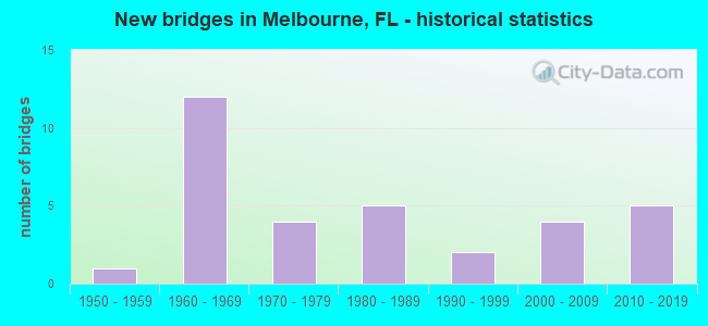
- New bridges - historical statistics
- 11950-1959
- 121960-1969
- 41970-1979
- 51980-1989
- 21990-1999
- 42000-2009
- 52010-2019

- Reconstructed bridges - Historical Statistics
- 41990-1999
- 42000-2009


- Bridge Condition - Deck
- 5.0%Very good
- 35.0%Good
- 45.0%Satisfactory
- 15.0%Fair

- Bridge Condition - Superstructure
- 10.0%Very good
- 55.0%Good
- 20.0%Satisfactory
- 15.0%Fair

- Bridge Condition - Substructure
- 5.0%Very good
- 55.0%Good
- 40.0%Satisfactory

- Bridge Condition - Channel
- 3.8%Excellent
- 23.1%Very good
- 57.7%Good
- 11.5%Satisfactory
- 3.8%Fair

- Bridge Condition - Culverts
- 25.0%Very good
- 37.5%Good
- 37.5%Satisfactory
Find on map >> Show street view
Structure Number: 700007, Location: US-1 over Elbow Creek (Lat: 28.118089, Lng: -80.628711), Route carried "on" structure: US 5, Year Built: 1961, Year Reconstructed: 1990, Status: Open, Structure Length: 9.85m (32.32ft), Average Daily Traffic: 49,000 (year 2020), Truck Traffic: 7%, Average Future Daily Traffic: 85,015 (year 2042), Design Load: HS 20, Features Intersected: Elbow Creek, Facility Carried by Structure: US-1
Minimum Vertical Clearance: 30+ m (98+ ft), Kilometerpoint: 5.200, Lanes on structure: 7, Base Highway Network: Yes, Owner: State Highway Agency, Approaching Roadway Width: 24.1m (79.1ft), Material/Design: Prestressed concrete, Design/Construction: Stringer/Multi-beam, Number Of Spans In Main Unit: 6, Length of Maximum Span: 16.3m (53.5ft), Curb or Sidewalk Widths: Left: 1.5m (4.9ft), Right: 1.5m (4.9ft), Curb-To-Curb Width: 25.9m (85.0ft), Out-to-Out Width: 30.4m (99.7ft)
Condition: Deck: Satisfactory, Superstructure: Good, Substructure: Satisfactory, Channel: Very good, Operating Rating: 48.9 metric tons, Method Used To Determine Operating Rating: Load Factor (LF), Inventory Rating: 29.3 metric tons, Method Used To Determine Inventory Rating: Load Factor (LF), Structural Evaluation: Equal to present minimum criteria, Deck Geometry: Meets minimum limits, Waterway Adequacy: Equal to present desirable criteria, Approach Roadway Alignment: Equal to present desirable criteria, Designated Inspection Frequency: Every 24 months, Underwater Inspection Frequency: Every 24 months, Inspection Date: November 2021, Underwater Inspection Date: November 2021, Deck Structure Type: Concrete Cast-file-Place, Wearing Surface/Protective System: Wearing Surface: Monolithic Concrete
Find on map >> Show street view
Structure Number: 700008, Location: US-1- Eau Gallie River (Lat: 28.124167, Lng: -80.630692), Route carried "on" structure: US 5, Year Built: 1961, Year Reconstructed: 1990, Status: Open, Structure Length: 8.23m (27.00ft), Average Daily Traffic: 54,000 (year 2020), Truck Traffic: 6%, Average Future Daily Traffic: 93,690 (year 2042), Design Load: HS 20, Features Intersected: Eau Gallie River, Facility Carried by Structure: US-1
Minimum Vertical Clearance: 30+ m (98+ ft), Kilometerpoint: 5.967, Lanes on structure: 7, Base Highway Network: Yes, Owner: State Highway Agency, Approaching Roadway Width: 23.7m (77.8ft), Material/Design: Prestressed concrete, Design/Construction: Stringer/Multi-beam, Number Of Spans In Main Unit: 5, Length of Maximum Span: 16.5m (54.1ft), Curb or Sidewalk Widths: Left: 1.5m (4.9ft), Right: 1.5m (4.9ft), Curb-To-Curb Width: 25.6m (84.0ft), Out-to-Out Width: 30.1m (98.8ft)
Condition: Deck: Satisfactory, Superstructure: Good, Substructure: Satisfactory, Channel: Very good, Operating Rating: 52.0 metric tons, Method Used To Determine Operating Rating: Load Factor (LF), Inventory Rating: 31.2 metric tons, Method Used To Determine Inventory Rating: Load Factor (LF), Structural Evaluation: Equal to present minimum criteria, Deck Geometry: Meets minimum limits, Waterway Adequacy: Equal to present desirable criteria, Approach Roadway Alignment: Equal to present desirable criteria, Length Of Structure Improvement: 8.17m (26.80ft), Designated Inspection Frequency: Every 24 months, Underwater Inspection Frequency: Every 24 months, Inspection Date: November 2021, Underwater Inspection Date: November 2021, Bridge Improvement Cost: $690,000, Total Project Cost: $843,000, Deck Structure Type: Concrete Cast-file-Place, Wearing Surface/Protective System: Wearing Surface: Monolithic Concrete
Find on map >> Show street view
Structure Number: 700023, Location: US-192 WB-St Johns Relief (Lat: 28.091742, Lng: -80.763792), Route carried "on" structure: US 500, Year Built: 1966, Year Reconstructed: 2004, Status: Open, Structure Length: 6.31m (20.70ft), Average Daily Traffic: 5,150 (year 2020), Truck Traffic: 19%, Average Future Daily Traffic: 8,935 (year 2042), Design Load: HS 20, Features Intersected: St Johns River Relief, Facility Carried by Structure: US-192 WB
Minimum Vertical Clearance: 30+ m (98+ ft), Kilometerpoint: 9.701, Lanes on structure: 2, Base Highway Network: Yes, Owner: State Highway Agency, Approaching Roadway Width: 9.8m (32.2ft), Material/Design: Prestressed concrete, Design/Construction: Stringer/Multi-beam, Number Of Spans In Main Unit: 5, Length of Maximum Span: 12.5m (41.0ft), Curb-To-Curb Width: 12.2m (40.0ft), Out-to-Out Width: 13.1m (43.0ft)
Condition: Deck: Good, Superstructure: Good, Substructure: Satisfactory, Channel: Good, Operating Rating: 67.9 metric tons, Method Used To Determine Operating Rating: Load Factor (LF), Inventory Rating: 43.6 metric tons, Method Used To Determine Inventory Rating: Load Factor (LF), Structural Evaluation: Equal to present minimum criteria, Deck Geometry: Better than present minimum criteria, Waterway Adequacy: Equal to present desirable criteria, Approach Roadway Alignment: Equal to present desirable criteria, Designated Inspection Frequency: Every 24 months, Underwater Inspection Frequency: Every 24 months, Inspection Date: March 2021, Underwater Inspection Date: March 2021, Deck Structure Type: Concrete Cast-file-Place, Wearing Surface/Protective System: Wearing Surface: Monolithic Concrete
Find on map >> Show street view
Structure Number: 700033, Location: .5 Mi W of SR-507 (Lat: 28.078697, Lng: -80.629597), Route carried "on" structure: US 500, Year Built: 1974, Status: Open, Structure Length: 1.55m (5.09ft), Average Daily Traffic: 35,500 (year 2020), Truck Traffic: 19%, Average Future Daily Traffic: 61,592 (year 2042), Design Load: HS 20, Features Intersected: Crane Creek, Facility Carried by Structure: US-192
Minimum Vertical Clearance: 30+ m (98+ ft), Kilometerpoint: 23.319, Lanes on structure: 5, Owner: State Highway Agency, Approaching Roadway Width: 21.0m (68.9ft), Skew: 12 degrees, Material/Design: Concrete, Design/Construction: Culvert, Number Of Spans In Main Unit: 4, Length of Maximum Span: 3.7m (12.1ft)
Condition: Channel: Good, Culverts: Satisfactory, Operating Rating: 68.8 metric tons, Method Used To Determine Operating Rating: Load Factor (LF), Inventory Rating: 41.3 metric tons, Method Used To Determine Inventory Rating: Load Factor (LF), Structural Evaluation: Equal to present minimum criteria, Waterway Adequacy: Equal to present desirable criteria, Approach Roadway Alignment: Equal to present desirable criteria, Designated Inspection Frequency: Every 24 months, Inspection Date: December 2021
Find on map >> Show street view
Structure Number: 700043, Location: I-95 SB -Lk Washington Rd (Lat: 28.146111, Lng: -80.706056), Route carried "on" structure: Interstate 95, Year Built: 1964, Year Reconstructed: 2009, Status: Open, Structure Length: 5.27m (17.29ft), Average Daily Traffic: 45,500 (year 2020), Truck Traffic: 10%, Average Future Daily Traffic: 78,942 (year 2042), Design Load: HS 20, Features Intersected: Lake Washington Road
Minimum Vertical Clearance: 30+ m (98+ ft), Kilometerpoint: 40.723, Lanes on structure: 3, Lanes under structure: 2, Base Highway Network: Yes, Owner: State Highway Agency, Approaching Roadway Width: 17.1m (56.1ft), Material/Design: Prestressed concrete, Design/Construction: Stringer/Multi-beam, Number Of Spans In Main Unit: 4, Length of Maximum Span: 15.4m (50.5ft), Curb-To-Curb Width: 17.1m (56.1ft), Out-to-Out Width: 18.0m (59.1ft)
Condition: Deck: Satisfactory, Superstructure: Good, Substructure: Good, Channel: Good, Operating Rating: 74.2 metric tons, Method Used To Determine Operating Rating: Load Factor (LF), Inventory Rating: 40.8 metric tons, Method Used To Determine Inventory Rating: Load Factor (LF), Structural Evaluation: Better than present minimum criteria, Deck Geometry: Equal to present minimum criteria, Underclear: Better than present minimum criteria, Waterway Adequacy: Better than present minimum criteria, Approach Roadway Alignment: Equal to present desirable criteria, Designated Inspection Frequency: Every 24 months, Inspection Date: January 2021, Deck Structure Type: Concrete Cast-file-Place
Find on map >> Show street view
Structure Number: 700122, Location: I-95 NB SR-518 (Lat: 28.120567, Lng: -80.705814), Route carried "on" structure: Interstate 95, Year Built: 1964, Year Reconstructed: 2009, Status: Open, Structure Length: 4.61m (15.12ft), Average Daily Traffic: 38,750 (year 2020), Truck Traffic: 15%, Average Future Daily Traffic: 67,231 (year 2042), Design Load: HS 20, Features Intersected: SR-518
Minimum Vertical Clearance: 30+ m (98+ ft), Kilometerpoint: 37.894, Lanes on structure: 3, Lanes under structure: 5, Base Highway Network: Yes, Owner: State Highway Agency, Approaching Roadway Width: 17.4m (57.1ft), Material/Design: Prestressed concrete, Design/Construction: Stringer/Multi-beam, Number Of Spans In Main Unit: 3, Length of Maximum Span: 24.0m (78.7ft), Curb-To-Curb Width: 17.4m (57.1ft), Out-to-Out Width: 18.3m (60.0ft)
Condition: Deck: Satisfactory, Superstructure: Satisfactory, Substructure: Good, Operating Rating: 70.9 metric tons, Method Used To Determine Operating Rating: Load Factor (LF), Inventory Rating: 41.5 metric tons, Method Used To Determine Inventory Rating: Load Factor (LF), Structural Evaluation: Equal to present minimum criteria, Deck Geometry: Better than present minimum criteria, Underclear: Meets minimum limits, Approach Roadway Alignment: Equal to present desirable criteria, Designated Inspection Frequency: Every 24 months, Inspection Date: January 2021, Deck Structure Type: Concrete Cast-file-Place
Find on map >> Show street view
Structure Number: 700123, Location: I-95 NB -Lk Washington Rd (Lat: 28.146111, Lng: -80.705769), Route carried "on" structure: Interstate 95, Year Built: 1964, Year Reconstructed: 2009, Status: Open, Structure Length: 5.27m (17.29ft), Average Daily Traffic: 45,500 (year 2020), Truck Traffic: 10%, Average Future Daily Traffic: 78,942 (year 2042), Design Load: HS 20, Features Intersected: Lake Washington Road
Minimum Vertical Clearance: 30+ m (98+ ft), Kilometerpoint: 40.723, Lanes on structure: 3, Lanes under structure: 2, Base Highway Network: Yes, Owner: State Highway Agency, Approaching Roadway Width: 17.1m (56.1ft), Material/Design: Prestressed concrete, Design/Construction: Stringer/Multi-beam, Number Of Spans In Main Unit: 4, Length of Maximum Span: 15.4m (50.5ft), Curb-To-Curb Width: 17.1m (56.1ft), Out-to-Out Width: 18.0m (59.1ft)
Condition: Deck: Satisfactory, Superstructure: Good, Substructure: Good, Channel: Good, Operating Rating: 74.2 metric tons, Method Used To Determine Operating Rating: Load Factor (LF), Inventory Rating: 40.8 metric tons, Method Used To Determine Inventory Rating: Load Factor (LF), Structural Evaluation: Better than present minimum criteria, Deck Geometry: Equal to present minimum criteria, Underclear: Equal to present minimum criteria, Waterway Adequacy: Better than present minimum criteria, Approach Roadway Alignment: Equal to present desirable criteria, Designated Inspection Frequency: Every 24 months, Inspection Date: January 2021, Deck Structure Type: Concrete Cast-file-Place
Find on map >> Show street view
Structure Number: 700172, Location: 0.2 Miles East of US-1 (Lat: 28.081161, Lng: -80.599667), Route carried "on" structure: US 192, Year Built: 1978, Status: Open, Structure Length: 1.04m (3.41ft), Average Daily Traffic: 37,000 (year 2020), Truck Traffic: 6%, Average Future Daily Traffic: 64,195 (year 2042), Design Load: HS 20, Features Intersected: Indian River Relief
Minimum Vertical Clearance: 30+ m (98+ ft), Kilometerpoint: 26.313, Lanes on structure: 6, Base Highway Network: Yes, Owner: State Highway Agency, Approaching Roadway Width: 23.9m (78.4ft), Skew: 10 degrees, Material/Design: Concrete, Design/Construction: Culvert, Number Of Spans In Main Unit: 3, Length of Maximum Span: 3.0m (9.8ft)
Condition: Channel: Good, Culverts: Satisfactory, Operating Rating: 48.2 metric tons, Method Used To Determine Operating Rating: Load Factor (LF), Inventory Rating: 28.8 metric tons, Method Used To Determine Inventory Rating: Load Factor (LF), Structural Evaluation: Equal to present minimum criteria, Waterway Adequacy: Equal to present desirable criteria, Approach Roadway Alignment: Equal to present desirable criteria, Length Of Structure Improvement: 1.04m (3.41ft), Designated Inspection Frequency: Every 24 months, Underwater Inspection Frequency: Every 24 months, Inspection Date: April 2020, Underwater Inspection Date: April 2020, Bridge Improvement Cost: $12,000, Total Project Cost: $2,612,000
Find on map >> Show street view
Structure Number: 700174, Location: US-192 WB-Indian River (Lat: 28.084275, Lng: -80.591633), Route carried "on" structure: US 192, Year Built: 1978, Status: Open, Structure Length: 79.03m (259.28ft), Average Daily Traffic: 18,500 (year 2020), Truck Traffic: 6%, Average Future Daily Traffic: 32,098 (year 2042), Design Load: HS 20, Features Intersected: Indian River IWW
Minimum Vertical Clearance: 30+ m (98+ ft), Kilometerpoint: 26.775, Lanes on structure: 2, Base Highway Network: Yes, Owner: State Highway Agency, Approaching Roadway Width: 12.3m (40.4ft), Navigation Control: Yes ( Vertical Clearance: 19.8m (65.0ft), Horizontal Clearance: 35.1m (115.2ft)), Material/Design: Steel continuous, Design/Construction: Stringer/Multi-beam, Number Of Spans In Main Unit: 3, Number Of Approach Spans: 24, Length of Maximum Span: 44.2m (145.0ft), Curb-To-Curb Width: 12.2m (40.0ft), Out-to-Out Width: 13.0m (42.7ft)
Condition: Deck: Satisfactory, Superstructure: Satisfactory, Substructure: Satisfactory, Channel: Good, Operating Rating: 56.7 metric tons, Method Used To Determine Operating Rating: Load Factor (LF), Inventory Rating: 34.0 metric tons, Method Used To Determine Inventory Rating: Load Factor (LF), Structural Evaluation: Equal to present minimum criteria, Deck Geometry: Better than present minimum criteria, Waterway Adequacy: Equal to present desirable criteria, Approach Roadway Alignment: Equal to present desirable criteria, Length Of Structure Improvement: 78.97m (259.09ft), Designated Inspection Frequency: Every 24 months, Underwater Inspection Frequency: Every 24 months, Inspection Date: March 2020, Underwater Inspection Date: April 2020, Bridge Improvement Cost: $9,000, Total Project Cost: $25,000, Deck Structure Type: Concrete Cast-file-Place, Wearing Surface/Protective System: Wearing Surface: Monolithic Concrete
Find on map >> Show street view
Structure Number: 700181, Location: US-192 EB - Indian River (Lat: 28.083992, Lng: -80.591497), Route carried "on" structure: US 192, Year Built: 1985, Status: Open, Structure Length: 79.03m (259.28ft), Average Daily Traffic: 18,500 (year 2020), Truck Traffic: 6%, Average Future Daily Traffic: 32,098 (year 2042), Design Load: HS 20, Features Intersected: Indian River IWW
Minimum Vertical Clearance: 30+ m (98+ ft), Kilometerpoint: 26.775, Lanes on structure: 2, Base Highway Network: Yes, Owner: State Highway Agency, Approaching Roadway Width: 10.1m (33.1ft), Navigation Control: Yes ( Vertical Clearance: 19.8m (65.0ft), Horizontal Clearance: 35.1m (115.2ft)), Material/Design: Steel continuous, Design/Construction: Stringer/Multi-beam, Number Of Spans In Main Unit: 3, Number Of Approach Spans: 24, Length of Maximum Span: 44.2m (145.0ft), Curb or Sidewalk Widths: Left: 0.0m, Right: 2.4m (7.9ft), Curb-To-Curb Width: 12.2m (40.0ft), Out-to-Out Width: 15.8m (51.8ft)
Condition: Deck: Good, Superstructure: Good, Substructure: Satisfactory, Channel: Satisfactory, Operating Rating: 64.1 metric tons, Method Used To Determine Operating Rating: Load Factor (LF), Inventory Rating: 38.5 metric tons, Method Used To Determine Inventory Rating: Load Factor (LF), Structural Evaluation: Equal to present minimum criteria, Deck Geometry: Better than present minimum criteria, Waterway Adequacy: Superior to present desirable criteria, Approach Roadway Alignment: Equal to present desirable criteria, Length Of Structure Improvement: 78.97m (259.09ft), Designated Inspection Frequency: Every 24 months, Underwater Inspection Frequency: Every 24 months, Inspection Date: March 2020, Underwater Inspection Date: April 2020, Bridge Improvement Cost: $9,000, Total Project Cost: $25,000, Deck Structure Type: Concrete Cast-file-Place, Wearing Surface/Protective System: Wearing Surface: Monolithic Concrete
Find on map >> Show street view
Structure Number: 700184, Location: SR-518 over Indian River (Lat: 28.132756, Lng: -80.617414), Route carried "on" structure: State highway 518, Year Built: 1988, Status: Open, Structure Length: 88.45m (290.19ft), Average Daily Traffic: 36,500 (year 2020), Truck Traffic: 5%, Average Future Daily Traffic: 63,328 (year 2042), Design Load: HS 20, Features Intersected: Indian River ICW
Minimum Vertical Clearance: 30+ m (98+ ft), Kilometerpoint: 9.392, Lanes on structure: 4, Base Highway Network: Yes, Owner: State Highway Agency, Approaching Roadway Width: 24.4m (80.1ft), Skew: 30 degrees, Navigation Control: Yes ( Vertical Clearance: 19.8m (65.0ft), Horizontal Clearance: 35.1m (115.2ft)), Material/Design: Prestressed concrete continuous, Design/Construction: Stringer/Multi-beam, Number Of Spans In Main Unit: 20, Length of Maximum Span: 44.2m (145.0ft), Curb or Sidewalk Widths: Left: 0.0m, Right: 1.5m (4.9ft), Curb-To-Curb Width: 24.4m (80.1ft), Out-to-Out Width: 27.6m (90.6ft)
Condition: Deck: Satisfactory, Superstructure: Good, Substructure: Satisfactory, Channel: Satisfactory, Operating Rating: 53.9 metric tons, Method Used To Determine Operating Rating: Load Testing, Inventory Rating: 32.7 metric tons, Method Used To Determine Inventory Rating: Load Testing, Structural Evaluation: Equal to present minimum criteria, Deck Geometry: Superior to present desirable criteria, Waterway Adequacy: Equal to present desirable criteria, Approach Roadway Alignment: Equal to present desirable criteria, Length Of Structure Improvement: 88.39m (289.99ft), Designated Inspection Frequency: Every 24 months, Underwater Inspection Frequency: Every 24 months, Inspection Date: June 2020, Underwater Inspection Date: July 2020, Bridge Improvement Cost: $805,000, Total Project Cost: $1,175,000, Deck Structure Type: Concrete Cast-file-Place, Wearing Surface/Protective System: Wearing Surface: Monolithic Concrete, Membrane: Epoxy, Deck Protection: Bituminous
Find on map >> Show street view
Structure Number: 700186, Location: SR-507 over Crane Creek (Lat: 28.068717, Lng: -80.621319), Route carried "on" structure: State highway 507, Year Built: 1982, Status: Open, Structure Length: 2.80m (9.19ft), Average Daily Traffic: 20,300 (year 2020), Truck Traffic: 3%, Average Future Daily Traffic: 35,220 (year 2042), Design Load: HS 20, Features Intersected: SR-507
Minimum Vertical Clearance: 30+ m (98+ ft), Kilometerpoint: 7.781, Lanes on structure: 4, Owner: State Highway Agency, Approaching Roadway Width: 19.2m (63.0ft), Skew: 20 degrees, Material/Design: Prestressed concrete, Design/Construction: Slab, Number Of Spans In Main Unit: 3, Length of Maximum Span: 9.1m (29.9ft), Curb or Sidewalk Widths: Left: 2.2m (7.2ft), Right: 1.5m (4.9ft), Curb-To-Curb Width: 20.2m (66.3ft), Out-to-Out Width: 25.0m (82.0ft)
Condition: Deck: Fair, Superstructure: Fair, Substructure: Good, Channel: Good, Operating Rating: 58.9 metric tons, Method Used To Determine Operating Rating: Load Factor (LF), Inventory Rating: 35.3 metric tons, Method Used To Determine Inventory Rating: Load Factor (LF), Structural Evaluation: Somewhat better than minimum adequacy, Deck Geometry: Better than present minimum criteria, Waterway Adequacy: Equal to present desirable criteria, Approach Roadway Alignment: Equal to present desirable criteria, Designated Inspection Frequency: Every 24 months, Underwater Inspection Frequency: Every 24 months, Inspection Date: May 2020, Underwater Inspection Date: May 2020, Deck Structure Type: Concrete Precast Panels, Wearing Surface/Protective System: Wearing Surface: Bituminous
Find on map >> Show street view
Structure Number: 700191, Location: SR-518 over Eau-Gallie R. (Lat: 28.128808, Lng: -80.650261), Route carried "on" structure: State highway 518, Year Built: 1993, Status: Open, Structure Length: 0.61m (2.00ft), Average Daily Traffic: 19,100 (year 2020), Truck Traffic: 19%, Average Future Daily Traffic: 33,138 (year 2042), Design Load: HS 20+Mod, Features Intersected: Eau-Gallie River
Minimum Vertical Clearance: 30+ m (98+ ft), Kilometerpoint: 5.193, Lanes on structure: 5, Owner: State Highway Agency, Approaching Roadway Width: 15.2m (49.9ft), Material/Design: Concrete, Design/Construction: Culvert, Number Of Spans In Main Unit: 2, Length of Maximum Span: 3.7m (12.1ft), Curb or Sidewalk Widths: Left: 1.5m (4.9ft), Right: 1.5m (4.9ft)
Condition: Channel: Satisfactory, Culverts: Good, Operating Rating: 82.8 metric tons, Method Used To Determine Operating Rating: Load Factor (LF), Inventory Rating: 49.7 metric tons, Method Used To Determine Inventory Rating: Load Factor (LF), Structural Evaluation: Better than present minimum criteria, Waterway Adequacy: Superior to present desirable criteria, Approach Roadway Alignment: Equal to present desirable criteria, Designated Inspection Frequency: Every 24 months, Inspection Date: May 2020
Find on map >> Show street view
Structure Number: 700203, Location: US-1 over Turkey Creek (Lat: 28.033272, Lng: -80.579811), Route carried "on" structure: US 5, Year Built: 1999, Status: Open, Structure Length: 6.81m (22.34ft), Average Daily Traffic: 29,500 (year 2020), Truck Traffic: 7%, Average Future Daily Traffic: 51,182 (year 2042), Design Load: HS 25 or greater, Features Intersected: Turkey Creek, Facility Carried by Structure: US-1
Minimum Vertical Clearance: 30+ m (98+ ft), Kilometerpoint: 21.947, Lanes on structure: 4, Base Highway Network: Yes, Owner: State Highway Agency, Approaching Roadway Width: 26.8m (87.9ft), Skew: 20 degrees, Material/Design: Prestressed concrete, Design/Construction: Slab, Number Of Spans In Main Unit: 6, Length of Maximum Span: 11.2m (36.7ft), Curb or Sidewalk Widths: Left: 1.5m (4.9ft), Right: 1.5m (4.9ft), Curb-To-Curb Width: 26.8m (87.9ft), Out-to-Out Width: 37.1m (121.7ft)
Condition: Deck: Fair, Superstructure: Fair, Substructure: Satisfactory, Channel: Excellent, Inventory Rating: 70.5 metric tons, Method Used To Determine Inventory Rating: Load Factor (LF), Structural Evaluation: Somewhat better than minimum adequacy, Deck Geometry: Superior to present desirable criteria, Waterway Adequacy: Equal to present desirable criteria, Approach Roadway Alignment: Equal to present desirable criteria, Designated Inspection Frequency: Every 24 months, Underwater Inspection Frequency: Every 24 months, Inspection Date: October 2020, Underwater Inspection Date: October 2020, Deck Structure Type: Concrete Precast Panels, Wearing Surface/Protective System: Wearing Surface: Monolithic Concrete, Deck Protection: Internally Sealed
Find on map >> Show street view
Structure Number: 700206, Location: US-1 over Horse Creek (Lat: 28.166744, Lng: -80.644694), Route carried "on" structure: US 1, Year Built: 2003, Status: Open, Structure Length: 2.68m (8.79ft), Average Daily Traffic: 47,500 (year 2020), Truck Traffic: 3%, Average Future Daily Traffic: 82,412 (year 2042), Design Load: HS 25 or greater, Features Intersected: Horse Creek
Minimum Vertical Clearance: 30+ m (98+ ft), Kilometerpoint: 11.021, Lanes on structure: 7, Owner: State Highway Agency, Approaching Roadway Width: 31.8m (104.3ft), Skew: 20 degrees, Material/Design: Concrete, Design/Construction: Slab, Number Of Spans In Main Unit: 3, Length of Maximum Span: 8.7m (28.5ft), Curb or Sidewalk Widths: Left: 1.5m (4.9ft), Right: 1.5m (4.9ft), Curb-To-Curb Width: 31.8m (104.3ft), Out-to-Out Width: 36.9m (121.1ft)
Condition: Deck: Satisfactory, Superstructure: Satisfactory, Substructure: Good, Channel: Very good, Operating Rating: 82.6 metric tons, Method Used To Determine Operating Rating: Load Factor (LF), Inventory Rating: 49.4 metric tons, Method Used To Determine Inventory Rating: Load Factor (LF), Structural Evaluation: Equal to present minimum criteria, Deck Geometry: Superior to present desirable criteria, Waterway Adequacy: Equal to present desirable criteria, Approach Roadway Alignment: Equal to present desirable criteria, Designated Inspection Frequency: Every 24 months, Underwater Inspection Frequency: Every 24 months, Inspection Date: October 2021, Underwater Inspection Date: October 2021, Deck Structure Type: Concrete Cast-file-Place, Wearing Surface/Protective System: Wearing Surface: Monolithic Concrete
Find on map >> Show street view
Structure Number: 700213, Location: US-192 EB-St Johns Relief (Lat: 28.091564, Lng: -80.763828), Route carried "on" structure: US 500, Year Built: 2004, Status: Open, Structure Length: 6.25m (20.51ft), Average Daily Traffic: 5,150 (year 2020), Truck Traffic: 19%, Average Future Daily Traffic: 8,935 (year 2042), Design Load: HS 20, Features Intersected: St Johns River Relief, Facility Carried by Structure: US-192 EB
Minimum Vertical Clearance: 30+ m (98+ ft), Kilometerpoint: 9.701, Lanes on structure: 2, Base Highway Network: Yes, Owner: State Highway Agency, Approaching Roadway Width: 9.1m (29.9ft), Material/Design: Prestressed concrete, Design/Construction: Stringer/Multi-beam, Number Of Spans In Main Unit: 5, Length of Maximum Span: 12.2m (40.0ft), Curb-To-Curb Width: 11.8m (38.7ft), Out-to-Out Width: 13.0m (42.7ft)
Condition: Deck: Good, Superstructure: Good, Substructure: Good, Channel: Good, Operating Rating: 78.1 metric tons, Method Used To Determine Operating Rating: Load Factor (LF), Inventory Rating: 49.1 metric tons, Method Used To Determine Inventory Rating: Load Factor (LF), Structural Evaluation: Better than present minimum criteria, Deck Geometry: Better than present minimum criteria, Waterway Adequacy: Equal to present desirable criteria, Approach Roadway Alignment: Equal to present desirable criteria, Designated Inspection Frequency: Every 24 months, Underwater Inspection Frequency: Every 24 months, Inspection Date: March 2021, Underwater Inspection Date: March 2021, Deck Structure Type: Concrete Cast-file-Place, Wearing Surface/Protective System: Wearing Surface: Monolithic Concrete
Find on map >> Show street view
Structure Number: 700214, Location: US-192 WB- St Johns River (Lat: 28.084853, Lng: -80.751119), Route carried "on" structure: US 500, Year Built: 2004, Status: Open, Structure Length: 32.55m (106.79ft), Average Daily Traffic: 5,150 (year 2020), Truck Traffic: 19%, Average Future Daily Traffic: 8,935 (year 2042), Design Load: HS 20, Features Intersected: St. Johns River, Facility Carried by Structure: US-192 WB
Minimum Vertical Clearance: 30+ m (98+ ft), Kilometerpoint: 11.042, Lanes on structure: 2, Base Highway Network: Yes, Owner: State Highway Agency, Approaching Roadway Width: 9.1m (29.9ft), Material/Design: Prestressed concrete, Design/Construction: Stringer/Multi-beam, Number Of Spans In Main Unit: 13, Length of Maximum Span: 25.0m (82.0ft), Curb-To-Curb Width: 12.0m (39.4ft), Out-to-Out Width: 12.8m (42.0ft)
Condition: Deck: Good, Superstructure: Good, Substructure: Good, Channel: Very good, Inventory Rating: 56.0 metric tons, Method Used To Determine Inventory Rating: Load Factor (LF), Structural Evaluation: Better than present minimum criteria, Deck Geometry: Better than present minimum criteria, Waterway Adequacy: Equal to present desirable criteria, Approach Roadway Alignment: Equal to present desirable criteria, Designated Inspection Frequency: Every 24 months, Underwater Inspection Frequency: Every 24 months, Inspection Date: January 2021, Underwater Inspection Date: January 2021, Deck Structure Type: Concrete Cast-file-Place, Wearing Surface/Protective System: Wearing Surface: Monolithic Concrete
Find on map >> Show street view
Structure Number: 700215, Location: US-192 EB-St Johns River (Lat: 28.084642, Lng: -80.751247), Route carried "on" structure: US 500, Year Built: 2004, Status: Open, Structure Length: 32.55m (106.79ft), Average Daily Traffic: 5,150 (year 2020), Truck Traffic: 19%, Average Future Daily Traffic: 8,935 (year 2042), Design Load: HS 20, Features Intersected: St Johns River, Facility Carried by Structure: US-192 EB
Minimum Vertical Clearance: 30+ m (98+ ft), Kilometerpoint: 11.042, Lanes on structure: 2, Base Highway Network: Yes, Owner: State Highway Agency, Approaching Roadway Width: 9.1m (29.9ft), Material/Design: Prestressed concrete, Design/Construction: Stringer/Multi-beam, Number Of Spans In Main Unit: 13, Length of Maximum Span: 25.0m (82.0ft), Curb-To-Curb Width: 12.0m (39.4ft), Out-to-Out Width: 12.8m (42.0ft)
Condition: Deck: Good, Superstructure: Very good, Substructure: Good, Channel: Very good, Inventory Rating: 56.0 metric tons, Method Used To Determine Inventory Rating: Load Factor (LF), Structural Evaluation: Better than present minimum criteria, Deck Geometry: Better than present minimum criteria, Waterway Adequacy: Equal to present desirable criteria, Approach Roadway Alignment: Equal to present desirable criteria, Designated Inspection Frequency: Every 24 months, Underwater Inspection Frequency: Every 24 months, Inspection Date: January 2021, Underwater Inspection Date: January 2021, Deck Structure Type: Concrete Cast-file-Place, Wearing Surface/Protective System: Wearing Surface: Monolithic Concrete
Find on map >> Show street view
Structure Number: 700941, Location: I-95 SB SR-518 (Lat: 28.120567, Lng: -80.706056), Route carried "on" structure: Interstate 95, Year Built: 1964, Year Reconstructed: 2009, Status: Open, Structure Length: 4.61m (15.12ft), Average Daily Traffic: 38,750 (year 2020), Truck Traffic: 15%, Average Future Daily Traffic: 67,231 (year 2042), Design Load: HS 20, Features Intersected: SR-518
Minimum Vertical Clearance: 30.45m (99.90ft), Kilometerpoint: 37.892, Lanes on structure: 3, Lanes under structure: 5, Base Highway Network: Yes, Owner: State Highway Agency, Approaching Roadway Width: 17.4m (57.1ft), Material/Design: Prestressed concrete, Design/Construction: Stringer/Multi-beam, Number Of Spans In Main Unit: 3, Length of Maximum Span: 24.0m (78.7ft), Curb-To-Curb Width: 17.4m (57.1ft), Out-to-Out Width: 18.3m (60.0ft)
Condition: Deck: Good, Superstructure: Good, Substructure: Good, Operating Rating: 70.9 metric tons, Method Used To Determine Operating Rating: Load Factor (LF), Inventory Rating: 41.5 metric tons, Method Used To Determine Inventory Rating: Load Factor (LF), Structural Evaluation: Better than present minimum criteria, Deck Geometry: Better than present minimum criteria, Underclear: Meets minimum limits, Approach Roadway Alignment: Equal to present desirable criteria, Designated Inspection Frequency: Every 24 months, Inspection Date: January 2021, Deck Structure Type: Concrete Cast-file-Place
Find on map >> Show street view
Structure Number: 704102, Location: 1.7 Miles N of Aurora Rd. (Lat: 28.161247, Lng: -80.655472), Route carried "on" structure: County highway , Year Built: 2011, Status: Open, Structure Length: 0.75m (2.46ft), Average Daily Traffic: 8,500 (year 2021), Truck Traffic: 5%, Average Future Daily Traffic: 14,748 (year 2042), Design Load: HL 93, Features Intersected: Horse Creek, Facility Carried by Structure: Croton Road
Minimum Vertical Clearance: 30+ m (98+ ft), Kilometerpoint: 1.582, Lanes on structure: 2, Owner: County Highway Agency, Approaching Roadway Width: 7.5m (24.6ft), Material/Design: Concrete, Design/Construction: Culvert, Number Of Spans In Main Unit: 2, Length of Maximum Span: 3.0m (9.8ft)
Condition: Channel: Good, Culverts: Good, Operating Rating: 53.5 metric tons, Method Used To Determine Operating Rating: Load and Resistance Factor (LRFR), Inventory Rating: 41.5 metric tons, Method Used To Determine Inventory Rating: Load and Resistance Factor (LRFR), Structural Evaluation: Better than present minimum criteria, Waterway Adequacy: Better than present minimum criteria, Approach Roadway Alignment: Equal to present desirable criteria, Designated Inspection Frequency: Every 24 months, Inspection Date: September 2021
Find on map >> Show street view
Structure Number: 704176, Location: 0.2 Mile S of Aurora Road (Lat: 28.132736, Lng: -80.655056), Route carried "on" structure: County highway , Year Built: 1989, Status: Open, Structure Length: 0.86m (2.82ft), Average Daily Traffic: 16,100 (year 2021), Truck Traffic: 15%, Average Future Daily Traffic: 27,934 (year 2042), Design Load: HS 20, Features Intersected: Eau Gallie River, Facility Carried by Structure: Croton Road
Minimum Vertical Clearance: 30+ m (98+ ft), Kilometerpoint: 1.223, Lanes on structure: 4, Owner: County Highway Agency, Approaching Roadway Width: 14.7m (48.2ft), Material/Design: Concrete, Design/Construction: Culvert, Number Of Spans In Main Unit: 3, Length of Maximum Span: 2.7m (8.9ft)
Condition: Channel: Fair, Culverts: Good, Operating Rating: 58.3 metric tons, Method Used To Determine Operating Rating: Load Factor (LF), Inventory Rating: 35.0 metric tons, Method Used To Determine Inventory Rating: Load Factor (LF), Structural Evaluation: Better than present minimum criteria, Waterway Adequacy: Superior to present desirable criteria, Approach Roadway Alignment: Equal to present desirable criteria, Designated Inspection Frequency: Every 24 months, Underwater Inspection Frequency: Every 24 months, Inspection Date: December 2021, Underwater Inspection Date: December 2021
Find on map >> Show street view
Structure Number: 704195, Location: 1.2 M N Lake Washington (Lat: 28.163000, Lng: -80.706481), Route carried "on" structure: County highway , Year Built: 2018, Status: Open, Structure Length: 0.85m (2.79ft), Average Daily Traffic: 501 (year 2020), Truck Traffic: 1%, Average Future Daily Traffic: 601 (year 2042), Design Load: HL 93, Features Intersected: Drainage Ditch, Facility Carried by Structure: Washingtonia Drive
Minimum Vertical Clearance: 30+ m (98+ ft), Kilometerpoint: 0.000, Lanes on structure: 2, Owner: County Highway Agency, Approaching Roadway Width: 12.6m (41.3ft), Material/Design: Concrete, Design/Construction: Culvert, Number Of Spans In Main Unit: 1, Length of Maximum Span: 2.4m (7.9ft)
Condition: Channel: Good, Culverts: Very good, Operating Rating: 59.8 metric tons, Method Used To Determine Operating Rating: Load and Resistance Factor (LRFR), Inventory Rating: 46.1 metric tons, Method Used To Determine Inventory Rating: Load and Resistance Factor (LRFR), Structural Evaluation: Equal to present desirable criteria, Waterway Adequacy: Superior to present desirable criteria, Approach Roadway Alignment: Equal to present desirable criteria, Designated Inspection Frequency: Every 24 months, Inspection Date: May 2020
Find on map >> Show street view
Structure Number: 704197, Location: 0.4 mi N of SR-518 (Lat: 28.134453, Lng: -80.671731), Route carried "on" structure: County highway 509, Year Built: 2016, Status: Open, Structure Length: 0.85m (2.79ft), Average Daily Traffic: 38,000 (year 2019), Truck Traffic: 2%, Average Future Daily Traffic: 65,930 (year 2041), Design Load: HL 93, Features Intersected: Eau Gallie River, Facility Carried by Structure: Wickham Road
Minimum Vertical Clearance: 30.45m (99.90ft), Kilometerpoint: 6.178, Lanes on structure: 5, Base Highway Network: Yes, Owner: County Highway Agency, Approaching Roadway Width: 18.3m (60.0ft), Material/Design: Concrete, Design/Construction: Culvert, Number Of Spans In Main Unit: 3, Length of Maximum Span: 2.7m (8.9ft)
Condition: Channel: Good, Culverts: Satisfactory, Operating Rating: 50.6 metric tons, Method Used To Determine Operating Rating: Load and Resistance Factor (LRFR), Inventory Rating: 38.8 metric tons, Method Used To Determine Inventory Rating: Load and Resistance Factor (LRFR), Structural Evaluation: Equal to present minimum criteria, Waterway Adequacy: Equal to present desirable criteria, Approach Roadway Alignment: Equal to present desirable criteria, Designated Inspection Frequency: Every 24 months, Inspection Date: October 2020
Find on map >> Show street view
Structure Number: 704198, Location: Just north of Ellis Road (Lat: 28.099150, Lng: -80.700194), Route carried "on" structure: County highway 511, Year Built: 2019, Status: Open, Structure Length: 0.67m (2.20ft), Average Daily Traffic: 6,400 (year 2022), Truck Traffic: 6%, Average Future Daily Traffic: 11,104 (year 2042), Design Load: HL 93, Features Intersected: Canal 15, Facility Carried by Structure: John Rodes Blvd.
Minimum Vertical Clearance: 30+ m (98+ ft), Kilometerpoint: 13.819, Lanes on structure: 3, Owner: County Highway Agency, Approaching Roadway Width: 18.3m (60.0ft), Material/Design: Concrete, Design/Construction: Culvert, Number Of Spans In Main Unit: 1, Length of Maximum Span: 3.0m (9.8ft)
Condition: Channel: Very good, Culverts: Very good, Operating Rating: 59.4 metric tons, Method Used To Determine Operating Rating: Load and Resistance Factor (LRFR), Inventory Rating: 45.7 metric tons, Method Used To Determine Inventory Rating: Load and Resistance Factor (LRFR), Structural Evaluation: Equal to present desirable criteria, Waterway Adequacy: Equal to present desirable criteria, Approach Roadway Alignment: Equal to present desirable criteria, Designated Inspection Frequency: Every 24 months, Inspection Date: January 2022
Find on map >> Show street view
Structure Number: 704203, Location: At Lake Washington Rd (Lat: 28.146167, Lng: -80.710861), Route carried "on" structure: County highway , Year Built: 1978, Year Reconstructed: 1995, Status: Posted for load, Structure Length: 0.91m (2.99ft), Average Daily Traffic: 251 (year 2022), Truck Traffic: 5%, Average Future Daily Traffic: 434 (year 2042), Design Load: HS 20, Features Intersected: Drainage Ditch, Facility Carried by Structure: Spotted Fawn Way
Minimum Vertical Clearance: 4.88m (16.01ft), Kilometerpoint: 0.008, Lanes on structure: 2, Owner: County Highway Agency, Approaching Roadway Width: 7.4m (24.3ft), Material/Design: Prestressed concrete, Design/Construction: Channel Beam, Number Of Spans In Main Unit: 1, Length of Maximum Span: 9.1m (29.9ft), Curb-To-Curb Width: 10.0m (32.8ft), Out-to-Out Width: 10.7m (35.1ft)
Condition: Deck: Satisfactory, Superstructure: Satisfactory, Substructure: Good, Channel: Good, Operating Rating: 25.1 metric tons, Method Used To Determine Operating Rating: Load and Resistance Factor (LRFR), Inventory Rating: 19.6 metric tons, Method Used To Determine Inventory Rating: Load and Resistance Factor (LRFR), Structural Evaluation: Somewhat better than minimum adequacy, Deck Geometry: Better than present minimum criteria, Waterway Adequacy: Better than present minimum criteria, Approach Roadway Alignment: Better than present minimum criteria, Bridge Posting: Required (Relationship of Operating Rating to Maximum Legal Load: 10.0 - 19.9% below), Designated Inspection Frequency: Every 24 months, Other Special Inspection Frequency: Every 12 months, Inspection Date: January 2022, Other Special Inspection Date: January 2022, Deck Structure Type: Concrete Cast-file-Place
Find on map >> Show street view
Structure Number: 705601, Location: 100 ft West of Ruffner Rd (Lat: 28.074653, Lng: -80.626764), Route carried "on" structure: City street , Year Built: 1960, Status: Posted for load, Structure Length: 0.93m (3.05ft), Average Daily Traffic: 1,008 (year 2021), Truck Traffic: 5%, Average Future Daily Traffic: 1,165 (year 2042), Design Load: HS 20, Features Intersected: Crane Creek, Facility Carried by Structure: Dubber Road
Minimum Vertical Clearance: 30+ m (98+ ft), Kilometerpoint: 0.000, Lanes on structure: 2, Owner: City or Municipal Highway Agency, Approaching Roadway Width: 7.4m (24.3ft), Material/Design: Prestressed concrete, Design/Construction: Slab, Number Of Spans In Main Unit: 1, Length of Maximum Span: 9.3m (30.5ft), Curb or Sidewalk Widths: Left: 1.1m (3.6ft), Right: 0.0m, Curb-To-Curb Width: 7.4m (24.3ft), Out-to-Out Width: 9.3m (30.5ft)
Condition: Deck: Fair, Superstructure: Fair, Substructure: Satisfactory, Channel: Good, Operating Rating: 71.9 metric tons, Method Used To Determine Operating Rating: Load Factor (LF), Inventory Rating: 43.2 metric tons, Method Used To Determine Inventory Rating: Load Factor (LF), Structural Evaluation: Somewhat better than minimum adequacy, Deck Geometry: Meets minimum limits, Waterway Adequacy: Equal to present desirable criteria, Approach Roadway Alignment: Better than present minimum criteria, Designated Inspection Frequency: Every 24 months, Inspection Date: December 2021, Deck Structure Type: Concrete Precast Panels, Wearing Surface/Protective System: Wearing Surface: Bituminous
Find on map >> Show street view
Structure Number: 705603, Location: 0.1 mi E of Wickham Road (Lat: 28.118344, Lng: -80.671564), Route carried "on" structure: City street , Year Built: 1950, Status: Posted for load, Structure Length: 1.16m (3.81ft), Average Daily Traffic: 3,012 (year 2021), Truck Traffic: 5%, Average Future Daily Traffic: 3,494 (year 2042), Design Load: HS 20, Features Intersected: Crane Creek Canal L-7, Facility Carried by Structure: Fountainhead Blvd.
Minimum Vertical Clearance: 30+ m (98+ ft), Kilometerpoint: 0.016, Lanes on structure: 2, Owner: City or Municipal Highway Agency, Approaching Roadway Width: 7.4m (24.3ft), Material/Design: Prestressed concrete, Design/Construction: Slab, Number Of Spans In Main Unit: 1, Length of Maximum Span: 11.6m (38.1ft), Curb or Sidewalk Widths: Left: 1.2m (3.9ft), Right: 1.2m (3.9ft), Curb-To-Curb Width: 7.4m (24.3ft), Out-to-Out Width: 10.5m (34.4ft)
Condition: Deck: Good, Superstructure: Good, Substructure: Good, Channel: Good, Operating Rating: 23.8 metric tons, Method Used To Determine Operating Rating: Load Factor (LF), Inventory Rating: 14.2 metric tons, Method Used To Determine Inventory Rating: Load Factor (LF), Structural Evaluation: Meets minimum limits, Deck Geometry: High priority of replacement, Waterway Adequacy: Equal to present desirable criteria, Approach Roadway Alignment: Equal to present desirable criteria, Bridge Posting: Required (Relationship of Operating Rating to Maximum Legal Load: 30.0 - 39.9% below), Designated Inspection Frequency: Every 24 months, Other Special Inspection Frequency: Every 12 months, Inspection Date: December 2021, Other Special Inspection Date: December 2021, Deck Structure Type: Concrete Precast Panels, Wearing Surface/Protective System: Wearing Surface: Bituminous
Find on map >> Show street view
Structure Number: 705604, Location: Apollo Blvd - Eau Gallie (Lat: 28.126972, Lng: -80.646139), Route carried "on" structure: City street , Year Built: 2015, Status: Open, Structure Length: 19.81m (64.99ft), Average Daily Traffic: 25,000 (year 2021), Truck Traffic: 18%, Average Future Daily Traffic: 43,375 (year 2042), Design Load: HL 93, Features Intersected: Eau Gallie River, Facility Carried by Structure: Apollo Boulevard
Minimum Vertical Clearance: 30.45m (99.90ft), Kilometerpoint: 4.915, Lanes on structure: 4, Owner: City or Municipal Highway Agency, Approaching Roadway Width: 21.9m (71.9ft), Material/Design: Prestressed concrete, Design/Construction: Stringer/Multi-beam, Number Of Spans In Main Unit: 12, Length of Maximum Span: 16.5m (54.1ft), Curb or Sidewalk Widths: Left: 1.5m (4.9ft), Right: 1.5m (4.9ft), Curb-To-Curb Width: 21.9m (71.9ft), Out-to-Out Width: 26.5m (86.9ft)
Condition: Deck: Very good, Superstructure: Very good, Substructure: Very good, Channel: Good, Operating Rating: 46.4 metric tons, Method Used To Determine Operating Rating: Load and Resistance Factor (LRFR), Inventory Rating: 42.9 metric tons, Method Used To Determine Inventory Rating: Load and Resistance Factor (LRFR), Structural Evaluation: Equal to present desirable criteria, Deck Geometry: Superior to present desirable criteria, Waterway Adequacy: Equal to present desirable criteria, Approach Roadway Alignment: Equal to present desirable criteria, Designated Inspection Frequency: Every 24 months, Underwater Inspection Frequency: Every 24 months, Inspection Date: November 2021, Underwater Inspection Date: November 2021, Deck Structure Type: Concrete Cast-file-Place
Find on map >> Show street view
Structure Number: 700043, Location: I-95 SB -Lk Washington Rd (Lat: 28.146111, Lng: -80.706056), Route carried "under" structure: City street , Year Built: 1964, Structure Length: 0. m, Average Daily Traffic: 900 (year 2020), Truck Traffic: 21%, Features Intersected: Lake Washington Road, Facility Carried by Structure: I-95 SB
Minimum Vertical Clearance: 4.97m (16.31ft), Kilometerpoint: 2.700, Lanes on structure: 3, Lanes under structure: 2, Material/Design: Prestressed concrete, Design/Construction: Stringer/Multi-beam, Length of Maximum Span: 15.4m (50.5ft)
Find on map >> Show street view
Structure Number: 700122, Location: I-95 NB SR-518 (Lat: 28.120567, Lng: -80.705814), Route carried "under" structure: State highway 518, Year Built: 1964, Structure Length: 0. m, Average Daily Traffic: 41,500 (year 2020), Truck Traffic: 11%, Features Intersected: SR-518, Facility Carried by Structure: I-95 NB
Minimum Vertical Clearance: 4.63m (15.19ft), Kilometerpoint: 0.274, Lanes on structure: 3, Lanes under structure: 5, Material/Design: Prestressed concrete, Design/Construction: Stringer/Multi-beam, Length of Maximum Span: 24.0m (78.7ft)
Find on map >> Show street view
Structure Number: 700123, Location: I-95 NB -Lk Washington Rd (Lat: 28.146111, Lng: -80.705769), Route carried "under" structure: City street , Year Built: 1964, Structure Length: 0. m, Average Daily Traffic: 4,300 (year 2020), Truck Traffic: 5%, Features Intersected: Lake Washington Road, Facility Carried by Structure: I-95 NB
Minimum Vertical Clearance: 4.94m (16.21ft), Kilometerpoint: 0.016, Lanes on structure: 3, Lanes under structure: 2, Material/Design: Prestressed concrete, Design/Construction: Stringer/Multi-beam, Length of Maximum Span: 15.4m (50.5ft)
Find on map >> Show street view
Structure Number: 700941, Location: I-95 SB SR-518 (Lat: 28.120567, Lng: -80.706056), Route carried "under" structure: State highway 518, Year Built: 1964, Structure Length: 0. m, Average Daily Traffic: 41,500 (year 2020), Truck Traffic: 11%, Features Intersected: SR-518, Facility Carried by Structure: I-95 SB
Minimum Vertical Clearance: 4.66m (15.29ft), Kilometerpoint: 0.243, Lanes on structure: 3, Lanes under structure: 5, Material/Design: Prestressed concrete, Design/Construction: Stringer/Multi-beam, Length of Maximum Span: 24.0m (78.7ft)
Find on map >> Show street view
Structure Number: 709004, Location: .5mi. south of SR-518 (Lat: 28.127778, Lng: -80.578056), Route carried "under" structure: State highway A1A, Year Built: 1985, Structure Length: 0. m, Average Daily Traffic: 6,100 (year 2003), Truck Traffic: 3%, Features Intersected: SR-A1A, Facility Carried by Structure: Ped. Overpass
Minimum Vertical Clearance: 4.91m (16.11ft), Kilometerpoint: 32.386, Lanes under structure: 7, Material/Design: Prestressed concrete, Design/Construction: Stringer/Multi-beam, Length of Maximum Span: 34.7m (113.8ft)