Bridge Statistics for Massena, New York (NY)
Condition, Traffic, Stress, Structural Evaluation, Project Costs
- National Bridge Inventory (NBI) Statistics
- 13Number of bridges
- 341ft / 104mTotal length
- $73,777,000Total costs
- 32,698Total average daily traffic
- 1,360Total average daily truck traffic
- National Bridge Inventory (NBI) Registered Bridges for Massena
- No street view available for this location
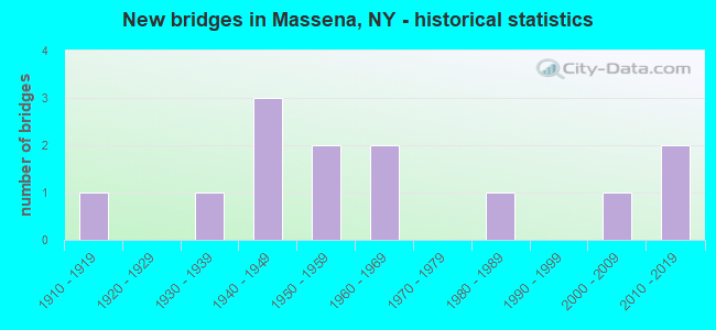
- New bridges - historical statistics
- 11910-1919
- 11930-1939
- 31940-1949
- 21950-1959
- 21960-1969
- 11980-1989
- 12000-2009
- 22010-2019


- Bridge Condition - Deck
- 14.3%Excellent
- 14.3%Very good
- 42.9%Good
- 14.3%Satisfactory
- 14.3%Poor

- Bridge Condition - Superstructure
- 28.6%Excellent
- 14.3%Very good
- 42.9%Good
- 14.3%Poor

- Bridge Condition - Substructure
- 28.6%Excellent
- 14.3%Very good
- 28.6%Good
- 14.3%Fair
- 14.3%Poor

- Bridge Condition - Channel
- 25.0%Excellent
- 37.5%Very good
- 12.5%Good
- 12.5%Fair
- 12.5%Poor
Find on map >> Show street view
Structure Number: 1024009, Location: .9 MI W JCT SH 37B & SH37 (Lat: 44.933108, Lng: -74.887117), Route carried "on" structure: State highway 37B, Year Built: 2018, Status: Open, Structure Length: 25.82m (84.71ft), Average Daily Traffic: 3,225 (year 2018), Truck Traffic: 4%, Average Future Daily Traffic: 3,240 (year 2040), Design Load: HL 93, Features Intersected: GRASSE RIVER
Minimum Vertical Clearance: 30+ m (98+ ft), Kilometerpoint: 4.328, Lanes on structure: 2, Base Highway Network: Yes, Owner: State Highway Agency, Approaching Roadway Width: 9.8m (32.2ft), Skew: 2 degrees, Material/Design: Steel continuous, Design/Construction: Stringer/Multi-beam, Number Of Spans In Main Unit: 4, Length of Maximum Span: 71.0m (232.9ft), Curb or Sidewalk Widths: Left: 1.6m (5.2ft), Right: 0.0m, Curb-To-Curb Width: 9.8m (32.2ft), Out-to-Out Width: 12.6m (41.3ft)
Condition: Deck: Very good, Superstructure: Excellent, Substructure: Excellent, Channel: Excellent, Operating Rating: 86.2 metric tons, Method Used To Determine Operating Rating: Load Factor (LF), Inventory Rating: 51.7 metric tons, Method Used To Determine Inventory Rating: Load Factor (LF), Structural Evaluation: Superior to present desirable criteria, Deck Geometry: Meets minimum limits, Waterway Adequacy: Somewhat better than minimum adequacy, Approach Roadway Alignment: Equal to present desirable criteria, Length Of Structure Improvement: 25.81m (84.68ft), Designated Inspection Frequency: Every 24 months, Inspection Date: August 2020, Bridge Improvement Cost: $6,021,000, Roadway Improvement Cost: $3,526,000, Total Project Cost: $9,547,000 ( Estimate for 2021), Deck Structure Type: Concrete Cast-file-Place, Wearing Surface/Protective System: Wearing Surface: Integral Concrete, Deck Protection: Epoxy Coated Reinforcing
Find on map >> Show street view
Structure Number: 104826, Location: JCT RTE 420 + RACQUETTE R (Lat: 44.916281, Lng: -74.888472), Route carried "on" structure: State highway 420, Year Built: 1966, Status: Open, Structure Length: 7.13m (23.39ft), Average Daily Traffic: 9,005 (year 2020), Truck Traffic: 8%, Average Future Daily Traffic: 10,939 (year 2040), Design Load: HS 20, Features Intersected: RAQUETTE RIVER
Minimum Vertical Clearance: 30+ m (98+ ft), Kilometerpoint: 18.504, Lanes on structure: 2, Base Highway Network: Yes, Owner: State Highway Agency, Approaching Roadway Width: 13.4m (44.0ft), Skew: 1 degrees, Material/Design: Steel, Design/Construction: Stringer/Multi-beam, Number Of Spans In Main Unit: 2, Length of Maximum Span: 34.7m (113.8ft), Curb or Sidewalk Widths: Left: 1.2m (3.9ft), Right: 1.2m (3.9ft), Curb-To-Curb Width: 13.4m (44.0ft), Out-to-Out Width: 16.6m (54.5ft)
Condition: Deck: Satisfactory, Superstructure: Good, Substructure: Good, Channel: Good, Operating Rating: 93.4 metric tons, Method Used To Determine Operating Rating: Load Factor (LF), Inventory Rating: 55.3 metric tons, Method Used To Determine Inventory Rating: Load Factor (LF), Structural Evaluation: Better than present minimum criteria, Deck Geometry: Equal to present minimum criteria, Waterway Adequacy: Equal to present minimum criteria, Approach Roadway Alignment: Equal to present desirable criteria, Length Of Structure Improvement: 7.13m (23.39ft), Designated Inspection Frequency: Every 24 months, Underwater Inspection Frequency: Every 60 months, Inspection Date: November 2021, Underwater Inspection Date: June 2021, Bridge Improvement Cost: $2,714,000, Roadway Improvement Cost: $1,589,000, Total Project Cost: $4,303,000 ( Estimate for 2021), Deck Structure Type: Concrete Cast-file-Place, Wearing Surface/Protective System: Wearing Surface: Monolithic Concrete
Find on map >> Show street view
Structure Number: 104827, Location: JCT RTE 420 + GRASSE R (Lat: 44.933394, Lng: -74.893031), Route carried "on" structure: State highway 970B, Year Built: 1917, Year Reconstructed: 2004, Status: Open, Structure Length: 10.55m (34.61ft), Average Daily Traffic: 6,854 (year 2018), Truck Traffic: 3%, Average Future Daily Traffic: 6,886 (year 2040), Features Intersected: GRASSE RIVER
Minimum Vertical Clearance: 30+ m (98+ ft), Kilometerpoint: 1.303, Lanes on structure: 2, Base Highway Network: Yes, Owner: State Highway Agency, Approaching Roadway Width: 12.2m (40.0ft), Material/Design: Concrete, Design/Construction: Arch - Deck, Number Of Spans In Main Unit: 4, Length of Maximum Span: 26.2m (86.0ft), Curb or Sidewalk Widths: Left: 2.1m (6.9ft), Right: 2.1m (6.9ft), Curb-To-Curb Width: 9.1m (29.9ft), Out-to-Out Width: 14.0m (45.9ft)
Condition: Deck: Good, Superstructure: Good, Substructure: Good, Channel: Very good, Operating Rating: 49.6 metric tons, Method Used To Determine Operating Rating: Field evaluation and documented engineering judgment, Inventory Rating: 16.9 metric tons, Method Used To Determine Inventory Rating: Field evaluation and documented engineering judgment, Structural Evaluation: Meets minimum limits, Deck Geometry: Meets minimum limits, Waterway Adequacy: Equal to present minimum criteria, Approach Roadway Alignment: Equal to present minimum criteria, Length Of Structure Improvement: 10.54m (34.58ft), Designated Inspection Frequency: Every 24 months, Inspection Date: June 2020, Bridge Improvement Cost: $6,259,000, Roadway Improvement Cost: $3,665,000, Total Project Cost: $9,925,000 ( Estimate for 2021), Wearing Surface/Protective System: Wearing Surface: Monolithic Concrete
Find on map >> Show street view
Structure Number: 322142, Location: 0.1 MI N Jct Rte 37 +37B (Lat: 44.939317, Lng: -74.870928), Route carried "on" structure: Other road , Year Built: 2002, Status: Open, Structure Length: 23.56m (77.30ft), Average Daily Traffic: 1,972 (year 2019), Truck Traffic: 6%, Average Future Daily Traffic: 2,395 (year 2040), Design Load: HS 25 or greater, Features Intersected: Grasse River, Facility Carried by Structure: Alcoa Road
Minimum Vertical Clearance: 32.69m (107.25ft), Kilometerpoint: 0.113, Lanes on structure: 2, Owner: County Highway Agency, Approaching Roadway Width: 9.4m (30.8ft), Material/Design: Steel continuous, Design/Construction: Stringer/Multi-beam, Number Of Spans In Main Unit: 3, Length of Maximum Span: 110.0m (360.9ft), Curb or Sidewalk Widths: Left: 1.6m (5.2ft), Right: 0.0m, Curb-To-Curb Width: 9.6m (31.5ft), Out-to-Out Width: 11.9m (39.0ft)
Condition: Deck: Good, Superstructure: Very good, Substructure: Very good, Channel: Very good, Operating Rating: 66.2 metric tons, Method Used To Determine Operating Rating: Load Factor (LF), Inventory Rating: 39.9 metric tons, Method Used To Determine Inventory Rating: Load Factor (LF), Structural Evaluation: Equal to present desirable criteria, Deck Geometry: Somewhat better than minimum adequacy, Waterway Adequacy: Equal to present desirable criteria, Approach Roadway Alignment: Equal to present desirable criteria, Length Of Structure Improvement: 23.56m (77.30ft), Designated Inspection Frequency: Every 24 months, Inspection Date: June 2020, Bridge Improvement Cost: $5,039,000, Roadway Improvement Cost: $2,951,000, Total Project Cost: $7,990,000 ( Estimate for 2021), Deck Structure Type: Concrete Cast-file-Place, Wearing Surface/Protective System: Wearing Surface: Bituminous, Membrane: Epoxy, Deck Protection: Epoxy Coated Reinforcing
Find on map >> Show street view
Structure Number: 33414, Location: 4.0 MI NE OF RAYMONDVILLE (Lat: 44.879506, Lng: -74.914572), Route carried "on" structure: Other road , Year Built: 2019, Status: Open, Structure Length: 2.01m (6.59ft), Average Daily Traffic: 498 (year 2016), Truck Traffic: 3%, Average Future Daily Traffic: 697 (year 2036), Design Load: HL 93, Features Intersected: PLUM BROOK, Facility Carried by Structure: BROUSE ROAD
Minimum Vertical Clearance: 30+ m (98+ ft), Kilometerpoint: 2.349, Lanes on structure: 2, Owner: County Highway Agency, Approaching Roadway Width: 7.6m (24.9ft), Material/Design: Prestressed concrete, Design/Construction: Box Beam or Girders - Multiple, Number Of Spans In Main Unit: 1, Length of Maximum Span: 18.8m (61.7ft), Curb-To-Curb Width: 7.6m (24.9ft), Out-to-Out Width: 8.5m (27.9ft)
Condition: Deck: Excellent, Superstructure: Excellent, Substructure: Excellent, Channel: Excellent, Operating Rating: 73.2 metric tons, Method Used To Determine Operating Rating: Load and Resistance Factor Rating (LRFR) rating reported by rating factor(RF) method using HL-93 loadings, Inventory Rating: 56.7 metric tons, Method Used To Determine Inventory Rating: Load and Resistance Factor Rating (LRFR) rating reported by rating factor(RF) method using HL-93 loadings, Structural Evaluation: Superior to present desirable criteria, Deck Geometry: Meets minimum limits, Waterway Adequacy: Somewhat better than minimum adequacy, Approach Roadway Alignment: Meets minimum limits, Length Of Structure Improvement: 2.01m (6.59ft), Designated Inspection Frequency: Every 24 months, Inspection Date: September 2021, Bridge Improvement Cost: $458,000, Roadway Improvement Cost: $268,000, Total Project Cost: $726,000 ( Estimate for 2021), Deck Structure Type: Other, Wearing Surface/Protective System: Wearing Surface: Bituminous, Membrane: Other
Find on map >> Show street view
Structure Number: 334142, Location: LOCATED NEAR PLUMBROOK (Lat: 44.850494, Lng: -74.908103), Route carried "on" structure: Other road , Year Built: 1968, Status: Open, Structure Length: 0.79m (2.59ft), Average Daily Traffic: 126 (year 2018), Truck Traffic: 6%, Average Future Daily Traffic: 176 (year 2038), Features Intersected: PLUM BROOK, Facility Carried by Structure: LACOMB ROAD
Minimum Vertical Clearance: 30+ m (98+ ft), Kilometerpoint: 0.322, Lanes on structure: 2, Owner: County Highway Agency, Approaching Roadway Width: 5.5m (18.0ft), Material/Design: Steel, Design/Construction: Stringer/Multi-beam, Number Of Spans In Main Unit: 1, Length of Maximum Span: 7.3m (24.0ft), Curb-To-Curb Width: 7.3m (24.0ft), Out-to-Out Width: 8.0m (26.2ft)
Condition: Deck: Poor, Superstructure: Poor, Substructure: Fair, Channel: Fair, Operating Rating: 65.3 metric tons, Method Used To Determine Operating Rating: Load Factor (LF), Inventory Rating: 39.0 metric tons, Method Used To Determine Inventory Rating: Load Factor (LF), Structural Evaluation: Meets minimum limits, Deck Geometry: Somewhat better than minimum adequacy, Waterway Adequacy: Somewhat better than minimum adequacy, Approach Roadway Alignment: Better than present minimum criteria, Length Of Structure Improvement: 0.79m (2.59ft), Designated Inspection Frequency: Every 24 months, Inspection Date: July 2021, Bridge Improvement Cost: $278,000, Roadway Improvement Cost: $163,000, Total Project Cost: $440,000 ( Estimate for 2021), Deck Structure Type: Open Grating, Wearing Surface/Protective System: Wearing Surface: Other
Find on map >> Show street view
Structure Number: 336741, Location: 1 MILE NW VIL OF MASSENA (Lat: 44.947761, Lng: -74.927575), Route carried "on" structure: County highway , Year Built: 1983, Status: Open, Structure Length: 1.04m (3.41ft), Average Daily Traffic: 1,084 (year 2019), Truck Traffic: 7%, Average Future Daily Traffic: 1,316 (year 2040), Features Intersected: DODGE CREEK, Facility Carried by Structure: COUNTY ROAD 43
Minimum Vertical Clearance: 30+ m (98+ ft), Kilometerpoint: 1.931, Lanes on structure: 2, Owner: County Highway Agency, Approaching Roadway Width: 7.6m (24.9ft), Material/Design: Steel, Design/Construction: Culvert, Number Of Spans In Main Unit: 3, Length of Maximum Span: 3.0m (9.8ft)
Condition: Channel: Poor, Culverts: Poor, Operating Rating: 73.8 metric tons, Method Used To Determine Operating Rating: Field evaluation and documented engineering judgment, Inventory Rating: 19.6 metric tons, Method Used To Determine Inventory Rating: Field evaluation and documented engineering judgment, Structural Evaluation: Meets minimum limits, Waterway Adequacy: Meets minimum limits, Approach Roadway Alignment: Equal to present desirable criteria, Length Of Structure Improvement: 1.03m (3.38ft), Designated Inspection Frequency: Every 24 months, Inspection Date: October 2021, Bridge Improvement Cost: $158,000, Roadway Improvement Cost: $93,000, Total Project Cost: $251,000 ( Estimate for 2021)
Find on map >> Show street view
Structure Number: 552363, Location: BARNHART IS & S CH ST LAW (Lat: 44.978392, Lng: -74.851594), Route carried "on" structure: Other road , Year Built: 1956, Year Reconstructed: 1997, Status: Open, Structure Length: 32.86m (107.81ft), Average Daily Traffic: 925 (year 2000), Truck Traffic: 10%, Average Future Daily Traffic: 1,295 (year 2020), Design Load: HS 20, Features Intersected: S CH ST LAWRENCE R, Facility Carried by Structure: BARNHART ISLAND RD
Minimum Vertical Clearance: 6.93m (22.74ft), Kilometerpoint: 0.000, Lanes on structure: 2, Owner: State Agenciy, Approaching Roadway Width: 11.6m (38.1ft), Navigation Control: Yes ( Vertical Clearance: 999.9m (3,280.5ft), Horizontal Clearance: 7.6m (24.9ft)), Material/Design: Steel continuous, Design/Construction: Truss - Thru, Number Of Spans In Main Unit: 3, Length of Maximum Span: 155.1m (508.9ft), Curb or Sidewalk Widths: Left: 1.5m (4.9ft), Right: 0.6m (2.0ft), Curb-To-Curb Width: 11.6m (38.1ft), Out-to-Out Width: 13.4m (44.0ft)
Condition: Deck: Good, Superstructure: Good, Substructure: Poor, Channel: Very good, Inventory Rating: 32.7 metric tons, Method Used To Determine Inventory Rating: Field evaluation and documented engineering judgment, Structural Evaluation: Meets minimum limits, Deck Geometry: Better than present minimum criteria, Waterway Adequacy: Equal to present desirable criteria, Approach Roadway Alignment: Equal to present desirable criteria, Length Of Structure Improvement: 32.85m (107.78ft), Designated Inspection Frequency: Every 24 months, Critical Feature Inspection Frequency: Every 12 months, Underwater Inspection Frequency: Every 60 months, Inspection Date: September 2021, Critical Feature Inspection Date: September 2021, Underwater Inspection Date: July 2019, Bridge Improvement Cost: $25,602,000, Roadway Improvement Cost: $14,993,000, Total Project Cost: $40,595,000 ( Estimate for 2021), Deck Structure Type: Concrete Cast-file-Place, Wearing Surface/Protective System: Wearing Surface: Integral Concrete, Deck Protection: Epoxy Coated Reinforcing
Find on map >> Show street view
Structure Number: 702389, Location: 1.2 MI NE JCT RTS 37 + 56 (Lat: 44.924728, Lng: -74.880306), Route carried "under" structure: State highway 37, Year Built: 1956, Structure Length: 0. m, Average Daily Traffic: 4,250 (year 1971), Features Intersected: RTE 37, Facility Carried by Structure: MASSENA TERMINAL
Minimum Vertical Clearance: 4.54m (14.90ft), Kilometerpoint: 103.748, Lanes under structure: 4, Material/Design: Steel continuous, Design/Construction: Stringer/Multi-beam, Length of Maximum Span: 18.8m (61.7ft)
Find on map >> Show street view
Structure Number: 702401, Location: 0.5 MI W JCT RTS 37B + 37 (Lat: 44.933275, Lng: -74.875819), Route carried "under" structure: Alternate State highway 37B, Year Built: 1931, Structure Length: 0. m, Average Daily Traffic: 4,759 (year 1999), Features Intersected: RTE 37B, Facility Carried by Structure: MASSENA TERMINAL
Minimum Vertical Clearance: 4.47m (14.67ft), Kilometerpoint: 5.615, Lanes under structure: 2, Material/Design: Steel, Design/Construction: Stringer/Multi-beam, Length of Maximum Span: 30.1m (98.8ft)
Find on map >> Show street view
Structure Number: 771573, Location: 0.5 MI E JCT Rt 420 (Lat: 44.919808, Lng: -74.879417), Route carried "under" structure: City street , Year Built: 1945, Structure Length: 0. m, Features Intersected: East Hatfield Street, Facility Carried by Structure: Massena Terminal
Minimum Vertical Clearance: 4.24m (13.91ft), Kilometerpoint: 0.000, Lanes under structure: 2, Material/Design: Steel, Design/Construction: Stringer/Multi-beam, Length of Maximum Span: 13.4m (44.0ft)
Find on map >> Show street view
Structure Number: 771574, Location: Massena (Lat: 44.937333, Lng: -74.878306), Route carried "under" structure: City street , Year Built: 1945, Structure Length: 0. m, Features Intersected: Center Street, Facility Carried by Structure: Massena Terminal
Minimum Vertical Clearance: 4.11m (13.48ft), Kilometerpoint: 0.000, Lanes under structure: 2, Material/Design: Prestressed concrete, Design/Construction: Frame, Length of Maximum Span: 8.8m (28.9ft)
Find on map >> Show street view
Structure Number: 771575, Location: Massena (Lat: 44.938322, Lng: -74.880639), Route carried "under" structure: City street , Year Built: 1945, Structure Length: 0. m, Features Intersected: Willow Street (CR42), Facility Carried by Structure: Massena Terminal
Minimum Vertical Clearance: 4.27m (14.01ft), Kilometerpoint: 0.000, Lanes under structure: 2, Material/Design: Steel, Design/Construction: Stringer/Multi-beam, Length of Maximum Span: 19.5m (64.0ft)