Bridge Statistics for Marietta, Ohio (OH)
Condition, Traffic, Stress, Structural Evaluation, Project Costs
- National Bridge Inventory (NBI) Statistics
- 29Number of bridges
- 932ft / 284mTotal length
- $100,000,000Total costs
- 226,637Total average daily traffic
- 19,028Total average daily truck traffic
- National Bridge Inventory (NBI) Registered Bridges for Marietta
- No street view available for this location
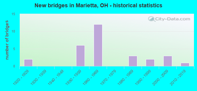
- New bridges - historical statistics
- 21920-1929
- 61950-1959
- 121960-1969
- 31980-1989
- 21990-1999
- 32000-2009
- 12010-2019

- Reconstructed bridges - Historical Statistics
- 41990-1999
- 12000-2009


- Bridge Condition - Deck
- 22.2%Very good
- 55.6%Good
- 16.7%Satisfactory
- 5.6%Fair

- Bridge Condition - Superstructure
- 16.7%Very good
- 66.7%Good
- 5.6%Satisfactory
- 11.1%Fair

- Bridge Condition - Substructure
- 5.6%Very good
- 72.2%Good
- 16.7%Satisfactory
- 5.6%Fair

- Bridge Condition - Channel
- 37.5%Very good
- 50.0%Good
- 12.5%Satisfactory

- Bridge Condition - Culverts
- 25.0%Very good
- 25.0%Good
- 50.0%Satisfactory
Find on map >> Show street view
Structure Number: 8400393, Location: 0.09M S OF JCT SR550 (Lat: 39.404381, Lng: -81.470961), Route carried "on" structure: State highway 7, Year Built: 1954, Status: Open, Structure Length: 1.38m (4.53ft), Average Daily Traffic: 12,666 (year 2015), Truck Traffic: 13%, Average Future Daily Traffic: 17,580 (year 2035), Design Load: H 15, Features Intersected: MILE RUN
Minimum Vertical Clearance: 30+ m (98+ ft), Kilometerpoint: 32.766, Lanes on structure: 2, Base Highway Network: Yes, Owner: State Highway Agency, Approaching Roadway Width: 13.4m (44.0ft), Skew: 4 degrees, Material/Design: Steel, Design/Construction: Culvert, Number Of Spans In Main Unit: 2, Length of Maximum Span: 6.0m (19.7ft)
Condition: Channel: Satisfactory, Culverts: Satisfactory, Operating Rating: 42.1 metric tons, Method Used To Determine Operating Rating: Load Factor (LF) rating reported by rating factor (RF) method using MS18 loading, Inventory Rating: 32.4 metric tons, Method Used To Determine Inventory Rating: Load Factor (LF) rating reported by rating factor (RF) method using MS18 loading, Structural Evaluation: Equal to present minimum criteria, Waterway Adequacy: Equal to present desirable criteria, Approach Roadway Alignment: Equal to present desirable criteria, Designated Inspection Frequency: Every 12 months, Inspection Date: November 2021
Find on map >> Show street view
Structure Number: 8400423, Location: 0.07M S OF JCT SR550 (Lat: 39.404661, Lng: -81.470600), Route carried "on" structure: State highway 7, Year Built: 1954, Year Reconstructed: 1999, Status: Open, Structure Length: 6.90m (22.64ft), Average Daily Traffic: 12,666 (year 2015), Truck Traffic: 13%, Average Future Daily Traffic: 17,580 (year 2035), Design Load: H 20, Features Intersected: CO. RD. 50 (VIRGINA ST.)
Minimum Vertical Clearance: 30+ m (98+ ft), Kilometerpoint: 32.815, Lanes on structure: 2, Lanes under structure: 2, Base Highway Network: Yes, Owner: State Highway Agency, Approaching Roadway Width: 11.6m (38.1ft), Skew: 3 degrees, Material/Design: Steel continuous, Design/Construction: Stringer/Multi-beam, Number Of Spans In Main Unit: 3, Length of Maximum Span: 25.9m (85.0ft), Curb-To-Curb Width: 10.7m (35.1ft), Out-to-Out Width: 11.6m (38.1ft)
Condition: Deck: Good, Superstructure: Good, Substructure: Good, Operating Rating: 87.5 metric tons, Method Used To Determine Operating Rating: Load Factor (LF) rating reported by rating factor (RF) method using MS18 loading, Inventory Rating: 51.8 metric tons, Method Used To Determine Inventory Rating: Load Factor (LF) rating reported by rating factor (RF) method using MS18 loading, Structural Evaluation: Better than present minimum criteria, Deck Geometry: Meets minimum limits, Underclear: Meets minimum limits, Approach Roadway Alignment: Better than present minimum criteria, Designated Inspection Frequency: Every 24 months, Inspection Date: November 2021, Deck Structure Type: Concrete Cast-file-Place, Wearing Surface/Protective System: Wearing Surface: Monolithic Concrete, Membrane: Built-up, Deck Protection: Epoxy Coated Reinforcing
Find on map >> Show street view
Structure Number: 8400784, Location: 1.5 MI N JCT SR 7 (Lat: 39.426269, Lng: -81.422200), Route carried "on" structure: State highway 26, Year Built: 1952, Year Reconstructed: 1997, Status: Open, Structure Length: 10.66m (34.97ft), Average Daily Traffic: 6,404 (year 2015), Truck Traffic: 7%, Average Future Daily Traffic: 8,889 (year 2035), Design Load: HS 20+Mod, Features Intersected: DUCK CREEK
Minimum Vertical Clearance: 30+ m (98+ ft), Kilometerpoint: 2.124, Lanes on structure: 2, Owner: State Highway Agency, Approaching Roadway Width: 8.5m (27.9ft), Skew: 1 degrees, Material/Design: Steel continuous, Design/Construction: Stringer/Multi-beam, Number Of Spans In Main Unit: 5, Length of Maximum Span: 22.9m (75.1ft), Curb or Sidewalk Widths: Left: 1.5m (4.9ft), Right: 1.5m (4.9ft), Curb-To-Curb Width: 8.5m (27.9ft), Out-to-Out Width: 12.2m (40.0ft)
Condition: Deck: Satisfactory, Superstructure: Good, Substructure: Good, Channel: Very good, Operating Rating: 42.1 metric tons, Method Used To Determine Operating Rating: Load and Resistance Factor Rating (LRFR) rating reported by rating factor(RF) method using HL-93 loadings, Inventory Rating: 32.4 metric tons, Method Used To Determine Inventory Rating: Load and Resistance Factor Rating (LRFR) rating reported by rating factor(RF) method using HL-93 loadings, Structural Evaluation: Better than present minimum criteria, Deck Geometry: Meets minimum limits, Waterway Adequacy: Equal to present desirable criteria, Approach Roadway Alignment: Equal to present desirable criteria, Designated Inspection Frequency: Every 12 months, Inspection Date: November 2021, Deck Structure Type: Concrete Cast-file-Place, Wearing Surface/Protective System: Wearing Surface: Monolithic Concrete, Deck Protection: Epoxy Coated Reinforcing
Find on map >> Show street view
Structure Number: 8400822, Location: 2.4 MI. N. OF JCT SR 7 (Lat: 39.428211, Lng: -81.414431), Route carried "on" structure: State highway 26, Year Built: 2004, Status: Open, Structure Length: 0.70m (2.30ft), Average Daily Traffic: 3,892 (year 2015), Truck Traffic: 6%, Average Future Daily Traffic: 5,402 (year 2035), Design Load: HS 25 or greater, Features Intersected: GOOSE RUN
Minimum Vertical Clearance: 30+ m (98+ ft), Kilometerpoint: 2.849, Lanes on structure: 2, Owner: State Highway Agency, Approaching Roadway Width: 7.9m (25.9ft), Skew: 3 degrees, Material/Design: Concrete, Design/Construction: Slab, Number Of Spans In Main Unit: 1, Length of Maximum Span: 6.4m (21.0ft), Curb-To-Curb Width: 9.1m (29.9ft), Out-to-Out Width: 18.3m (60.0ft)
Condition: Deck: Very good, Superstructure: Very good, Substructure: Very good, Channel: Very good, Operating Rating: 97.2 metric tons, Method Used To Determine Operating Rating: Load Factor (LF) rating reported by rating factor (RF) method using MS18 loading, Inventory Rating: 87.5 metric tons, Method Used To Determine Inventory Rating: Load Factor (LF) rating reported by rating factor (RF) method using MS18 loading, Structural Evaluation: Equal to present desirable criteria, Deck Geometry: Meets minimum limits, Waterway Adequacy: Equal to present desirable criteria, Approach Roadway Alignment: Better than present minimum criteria, Designated Inspection Frequency: Every 24 months, Inspection Date: November 2021, Deck Structure Type: Concrete Cast-file-Place, Wearing Surface/Protective System: Wearing Surface: Bituminous
Find on map >> Show street view
Structure Number: 8402108, Location: 1.12M N OF JCT SR550 (Lat: 39.419031, Lng: -81.464239), Route carried "on" structure: State highway 7, Year Built: 1953, Year Reconstructed: 2009, Status: Open, Structure Length: 31.60m (103.67ft), Average Daily Traffic: 10,799 (year 2015), Truck Traffic: 11%, Average Future Daily Traffic: 14,989 (year 2035), Design Load: HS 20, Features Intersected: MUSK.R.FRONT&GILMAN STS.
Minimum Vertical Clearance: 30+ m (98+ ft), Kilometerpoint: 34.665, Lanes on structure: 2, Lanes under structure: 4, Base Highway Network: Yes, Owner: State Highway Agency, Approaching Roadway Width: 9.1m (29.9ft), Navigation Control: Yes ( Vertical Clearance: 16.5m (54.1ft), Horizontal Clearance: 39.9m (130.9ft)), Material/Design: Steel continuous, Design/Construction: Stringer/Multi-beam, Number Of Spans In Main Unit: 7, Number Of Approach Spans: 3, Length of Maximum Span: 41.1m (134.8ft), Curb or Sidewalk Widths: Left: 1.2m (3.9ft), Right: 1.2m (3.9ft), Curb-To-Curb Width: 8.9m (29.2ft), Out-to-Out Width: 11.6m (38.1ft)
Condition: Deck: Very good, Superstructure: Very good, Substructure: Good, Channel: Very good, Operating Rating: 22.7 metric tons, Method Used To Determine Operating Rating: Load and Resistance Factor Rating (LRFR) rating reported by rating factor(RF) method using HL-93 loadings, Inventory Rating: 16.2 metric tons, Method Used To Determine Inventory Rating: Load and Resistance Factor Rating (LRFR) rating reported by rating factor(RF) method using HL-93 loadings, Structural Evaluation: Meets minimum limits, Deck Geometry: Meets minimum limits, Underclear: High priority of corrective action, Waterway Adequacy: Equal to present desirable criteria, Approach Roadway Alignment: Equal to present minimum criteria, Designated Inspection Frequency: Every 12 months, Critical Feature Inspection Frequency: Every 24 months, Underwater Inspection Frequency: Every 60 months, Inspection Date: November 2021, Critical Feature Inspection Date: November 2021, Underwater Inspection Date: July 2019, Deck Structure Type: Concrete Cast-file-Place, Wearing Surface/Protective System: Wearing Surface: Monolithic Concrete
Find on map >> Show street view
Structure Number: 8402167, Location: 0.12M N INTERSECT.OF I-77 (Lat: 39.408900, Lng: -81.423781), Route carried "on" structure: State highway 7, Year Built: 1966, Status: Open, Structure Length: 8.06m (26.44ft), Average Daily Traffic: 24,836 (year 2015), Truck Traffic: 5%, Average Future Daily Traffic: 34,472 (year 2035), Design Load: H 20, Features Intersected: DUCK CREEK
Minimum Vertical Clearance: 30+ m (98+ ft), Kilometerpoint: 39.059, Lanes on structure: 4, Base Highway Network: Yes, Owner: State Highway Agency, Approaching Roadway Width: 21.8m (71.5ft), Skew: 11 degrees, Material/Design: Steel continuous, Design/Construction: Stringer/Multi-beam, Number Of Spans In Main Unit: 3, Length of Maximum Span: 30.5m (100.1ft), Curb-To-Curb Width: 18.3m (60.0ft), Out-to-Out Width: 23.3m (76.4ft)
Condition: Deck: Good, Superstructure: Good, Substructure: Good, Channel: Good, Operating Rating: 42.1 metric tons, Method Used To Determine Operating Rating: Allowable Stress (AS) rating reported by rating factor (RF) method using MS18 loading, Inventory Rating: 32.4 metric tons, Method Used To Determine Inventory Rating: Allowable Stress (AS) rating reported by rating factor (RF) method using MS18 loading, Structural Evaluation: Better than present minimum criteria, Deck Geometry: Somewhat better than minimum adequacy, Waterway Adequacy: Equal to present desirable criteria, Approach Roadway Alignment: Equal to present desirable criteria, Designated Inspection Frequency: Every 24 months, Inspection Date: November 2021, Deck Structure Type: Concrete Cast-file-Place, Wearing Surface/Protective System: Wearing Surface: Integral Concrete
Find on map >> Show street view
Structure Number: 8402485, Location: SR 60 @ STATE LINE (Lat: 39.410700, Lng: -81.447961), Route carried "on" structure: State highway 60, Year Built: 1992, Status: Open, Structure Length: 76.11m (249.70ft), Average Daily Traffic: 12,688 (year 2019), Truck Traffic: 4%, Average Future Daily Traffic: 15,733 (year 2039), Design Load: HS 25 or greater, Features Intersected: WILLIAMSTOWN BRIDGE
Minimum Vertical Clearance: 5.44m (17.85ft), Kilometerpoint: 0.000, Lanes on structure: 2, Base Highway Network: Yes, Owner: State Highway Agency, Approaching Roadway Width: 9.1m (29.9ft), Navigation Control: Yes ( Vertical Clearance: 26.8m (87.9ft), Horizontal Clearance: 472.1m (1,548.9ft)), Material/Design: Steel, Design/Construction: Truss - Thru, Number Of Spans In Main Unit: 2, Number Of Approach Spans: 10, Length of Maximum Span: 198.4m (650.9ft), Curb-To-Curb Width: 9.5m (31.2ft), Out-to-Out Width: 10.2m (33.5ft)
Condition: Deck: Good, Superstructure: Good, Substructure: Satisfactory, Channel: Very good, Operating Rating: 42.1 metric tons, Method Used To Determine Operating Rating: Load Factor (LF) rating reported by rating factor (RF) method using MS18 loading, Inventory Rating: 32.4 metric tons, Method Used To Determine Inventory Rating: Load Factor (LF) rating reported by rating factor (RF) method using MS18 loading, Structural Evaluation: Equal to present minimum criteria, Deck Geometry: Meets minimum limits, Waterway Adequacy: Equal to present desirable criteria, Approach Roadway Alignment: Equal to present minimum criteria, Designated Inspection Frequency: Every 24 months, Critical Feature Inspection Frequency: Every 24 months, Underwater Inspection Frequency: Every 60 months, Other Special Inspection Frequency: Every 12 months, Inspection Date: October 2020, Critical Feature Inspection Date: October 2020, Underwater Inspection Date: September 2019, Other Special Inspection Date: October 2020, Deck Structure Type: Concrete Cast-file-Place, Wearing Surface/Protective System: Wearing Surface: Monolithic Concrete
Find on map >> Show street view
Structure Number: 8402906, Location: STATE LINE (Lat: 39.404939, Lng: -81.429350), Route carried "on" structure: Interstate 77, Year Built: 1965, Status: Open, Structure Length: 79.72m (261.55ft), Average Daily Traffic: 19,477 (year 2015), Truck Traffic: 11%, Average Future Daily Traffic: 38,954 (year 2040), Design Load: HS 20+Mod, Features Intersected: Ohio River, CR 1 & CSX
Minimum Vertical Clearance: 6.07m (19.91ft), Kilometerpoint: 0.000, Lanes on structure: 4, Lanes under structure: 2, Base Highway Network: Yes, Owner: State Highway Agency, Approaching Roadway Width: 28.7m (94.2ft), Skew: 30 degrees, Navigation Control: Yes ( Vertical Clearance: 21.3m (69.9ft), Horizontal Clearance: 194.2m (637.1ft)), Material/Design: Steel, Design/Construction: Girder and Floorbeam System, Number Of Spans In Main Unit: 1, Number Of Approach Spans: 10, Length of Maximum Span: 198.4m (650.9ft), Curb-To-Curb Width: 18.3m (60.0ft), Out-to-Out Width: 20.7m (67.9ft)
Condition: Deck: Satisfactory, Superstructure: Fair, Substructure: Satisfactory, Channel: Good, Operating Rating: 42.1 metric tons, Method Used To Determine Operating Rating: Allowable Stress (AS) rating reported by rating factor (RF) method using MS18 loading, Inventory Rating: 32.4 metric tons, Method Used To Determine Inventory Rating: Allowable Stress (AS) rating reported by rating factor (RF) method using MS18 loading, Structural Evaluation: Somewhat better than minimum adequacy, Deck Geometry: Meets minimum limits, Underclear: Meets minimum limits, Waterway Adequacy: Superior to present desirable criteria, Approach Roadway Alignment: Equal to present desirable criteria, Length Of Structure Improvement: 79.71m (261.52ft), Designated Inspection Frequency: Every 24 months, Critical Feature Inspection Frequency: Every 12 months, Underwater Inspection Frequency: Every 60 months, Other Special Inspection Frequency: Every 12 months, Inspection Date: August 2020, Critical Feature Inspection Date: July 2021, Underwater Inspection Date: August 2020, Other Special Inspection Date: July 2021, Roadway Improvement Cost: $100,000,000, Total Project Cost: $100,000,000, Deck Structure Type: Concrete Cast-file-Place, Wearing Surface/Protective System: Wearing Surface: Monolithic Concrete, Deck Protection: Epoxy Coated Reinforcing
Find on map >> Show street view
Structure Number: 8402914, Location: 0.13M N W.VA STATE LINE (Lat: 39.407100, Lng: -81.427411), Route carried "on" structure: Interstate 77, Year Built: 1967, Status: Open, Structure Length: 0.65m (2.13ft), Average Daily Traffic: 19,477 (year 2015), Truck Traffic: 11%, Average Future Daily Traffic: 27,034 (year 2035), Design Load: HS 20, Features Intersected: OVR PRR SPUR (PIPE)
Minimum Vertical Clearance: 30+ m (98+ ft), Kilometerpoint: 0.209, Lanes on structure: 4, Base Highway Network: Yes, Owner: State Highway Agency, Approaching Roadway Width: 14.6m (47.9ft), Material/Design: Steel, Design/Construction: Culvert, Number Of Spans In Main Unit: 1, Length of Maximum Span: 6.5m (21.3ft)
Condition: Culverts: Satisfactory, Operating Rating: 42.1 metric tons, Method Used To Determine Operating Rating: Load Factor (LF) rating reported by rating factor (RF) method using MS18 loading, Inventory Rating: 32.4 metric tons, Method Used To Determine Inventory Rating: Load Factor (LF) rating reported by rating factor (RF) method using MS18 loading, Structural Evaluation: Equal to present minimum criteria, Approach Roadway Alignment: Equal to present desirable criteria, Designated Inspection Frequency: Every 12 months, Inspection Date: October 2021
Find on map >> Show street view
Structure Number: 8402949, Location: 0.3M N W.VA. STATE LINE (Lat: 39.409361, Lng: -81.425300), Route carried "on" structure: Interstate 77, Year Built: 1967, Status: Open, Structure Length: 6.99m (22.93ft), Average Daily Traffic: 15,399 (year 2015), Truck Traffic: 11%, Average Future Daily Traffic: 21,374 (year 2035), Design Load: HS 20, Features Intersected: SR 7
Minimum Vertical Clearance: 30+ m (98+ ft), Kilometerpoint: 0.483, Lanes on structure: 4, Lanes under structure: 4, Base Highway Network: Yes, Owner: State Highway Agency, Approaching Roadway Width: 11.0m (36.1ft), Skew: 1 degrees, Material/Design: Steel continuous, Design/Construction: Stringer/Multi-beam, Number Of Spans In Main Unit: 4, Length of Maximum Span: 20.2m (66.3ft), Curb-To-Curb Width: 25.6m (84.0ft), Out-to-Out Width: 27.4m (89.9ft)
Condition: Deck: Good, Superstructure: Good, Substructure: Good, Operating Rating: 55.7 metric tons, Method Used To Determine Operating Rating: Load Factor (LF) rating reported by rating factor (RF) method using MS18 loading, Inventory Rating: 33.4 metric tons, Method Used To Determine Inventory Rating: Load Factor (LF) rating reported by rating factor (RF) method using MS18 loading, Structural Evaluation: Better than present minimum criteria, Deck Geometry: Superior to present desirable criteria, Underclear: High priority of corrective action, Approach Roadway Alignment: Equal to present desirable criteria, Designated Inspection Frequency: Every 24 months, Inspection Date: October 2021, Deck Structure Type: Concrete Cast-file-Place, Wearing Surface/Protective System: Wearing Surface: Latex Concrete
Find on map >> Show street view
Structure Number: 8402973, Location: 1.35M N W.VA. STATE LINE (Lat: 39.421919, Lng: -81.426419), Route carried "on" structure: Interstate 77, Year Built: 1966, Status: Open, Structure Length: 6.63m (21.75ft), Average Daily Traffic: 7,711 (year 2015), Truck Traffic: 11%, Average Future Daily Traffic: 10,703 (year 2035), Design Load: HS 20, Features Intersected: SR 26
Minimum Vertical Clearance: 30+ m (98+ ft), Kilometerpoint: 2.173, Lanes on structure: 2, Lanes under structure: 2, Base Highway Network: Yes, Owner: State Highway Agency, Approaching Roadway Width: 11.6m (38.1ft), Skew: 3 degrees, Material/Design: Steel continuous, Design/Construction: Stringer/Multi-beam, Number Of Spans In Main Unit: 3, Length of Maximum Span: 26.8m (87.9ft), Curb-To-Curb Width: 12.1m (39.7ft), Out-to-Out Width: 13.5m (44.3ft)
Condition: Deck: Very good, Superstructure: Good, Substructure: Good, Operating Rating: 55.1 metric tons, Method Used To Determine Operating Rating: Load Factor (LF) rating reported by rating factor (RF) method using MS18 loading, Inventory Rating: 32.4 metric tons, Method Used To Determine Inventory Rating: Load Factor (LF) rating reported by rating factor (RF) method using MS18 loading, Structural Evaluation: Better than present minimum criteria, Deck Geometry: Equal to present minimum criteria, Underclear: Equal to present minimum criteria, Approach Roadway Alignment: Equal to present desirable criteria, Designated Inspection Frequency: Every 24 months, Inspection Date: October 2021, Deck Structure Type: Concrete Cast-file-Place, Wearing Surface/Protective System: Wearing Surface: Latex Concrete
Find on map >> Show street view
Structure Number: 8403007, Location: 1.35M N W.VA. STATE LINE (Lat: 39.422100, Lng: -81.426289), Route carried "on" structure: Interstate 77, Year Built: 1966, Status: Open, Structure Length: 6.63m (21.75ft), Average Daily Traffic: 7,711 (year 2015), Truck Traffic: 11%, Average Future Daily Traffic: 10,703 (year 2035), Design Load: HS 20, Features Intersected: SR 26
Minimum Vertical Clearance: 30+ m (98+ ft), Kilometerpoint: 2.173, Lanes on structure: 2, Lanes under structure: 2, Base Highway Network: Yes, Owner: State Highway Agency, Approaching Roadway Width: 11.6m (38.1ft), Skew: 3 degrees, Material/Design: Steel continuous, Design/Construction: Stringer/Multi-beam, Number Of Spans In Main Unit: 3, Length of Maximum Span: 26.8m (87.9ft), Curb-To-Curb Width: 12.1m (39.7ft), Out-to-Out Width: 13.5m (44.3ft)
Condition: Deck: Good, Superstructure: Good, Substructure: Good, Operating Rating: 36.9 metric tons, Method Used To Determine Operating Rating: Allowable Stress (AS) rating reported by rating factor (RF) method using MS18 loading, Inventory Rating: 28.5 metric tons, Method Used To Determine Inventory Rating: Allowable Stress (AS) rating reported by rating factor (RF) method using MS18 loading, Structural Evaluation: Better than present minimum criteria, Deck Geometry: Equal to present minimum criteria, Underclear: Equal to present minimum criteria, Approach Roadway Alignment: Equal to present desirable criteria, Designated Inspection Frequency: Every 24 months, Inspection Date: October 2021, Deck Structure Type: Concrete Cast-file-Place, Wearing Surface/Protective System: Wearing Surface: Latex Concrete
Find on map >> Show street view
Structure Number: 8403031, Location: 2.8M N W.VA. STATE LINE (Lat: 39.441911, Lng: -81.433481), Route carried "on" structure: County highway C0375, Year Built: 1965, Status: Open, Structure Length: 6.93m (22.74ft), Average Daily Traffic: 1,452 (year 2015), Truck Traffic: 2%, Average Future Daily Traffic: 21,404 (year 2035), Design Load: H 15, Features Intersected: I 77, Facility Carried by Structure: CR 375
Minimum Vertical Clearance: 30+ m (98+ ft), Kilometerpoint: 3.653, Lanes on structure: 2, Lanes under structure: 4, Owner: State Highway Agency, Approaching Roadway Width: 7.3m (24.0ft), Skew: 2 degrees, Material/Design: Steel continuous, Design/Construction: Stringer/Multi-beam, Number Of Spans In Main Unit: 4, Length of Maximum Span: 19.4m (63.6ft), Curb-To-Curb Width: 7.3m (24.0ft), Out-to-Out Width: 9.4m (30.8ft)
Condition: Deck: Satisfactory, Superstructure: Good, Substructure: Good, Operating Rating: 32.4 metric tons, Method Used To Determine Operating Rating: Allowable Stress (AS) rating reported by rating factor (RF) method using MS18 loading, Inventory Rating: 25.9 metric tons, Method Used To Determine Inventory Rating: Allowable Stress (AS) rating reported by rating factor (RF) method using MS18 loading, Structural Evaluation: Equal to present minimum criteria, Deck Geometry: Meets minimum limits, Underclear: High priority of corrective action, Approach Roadway Alignment: Equal to present desirable criteria, Designated Inspection Frequency: Every 12 months, Inspection Date: October 2021, Deck Structure Type: Concrete Cast-file-Place, Wearing Surface/Protective System: Wearing Surface: Bituminous
Find on map >> Show street view
Structure Number: 8430128, Location: Putnam Street, Marietta C (Lat: 39.413511, Lng: -81.457700), Route carried "on" structure: City street C0000, Year Built: 2000, Status: Open, Structure Length: 20.91m (68.60ft), Average Daily Traffic: 6,172 (year 2015), Truck Traffic: 2%, Average Future Daily Traffic: 8,567 (year 2035), Design Load: HS 20+Mod, Features Intersected: MUSKINGUM R * PUTNAM BRG, Facility Carried by Structure: PUTNAM STREET
Minimum Vertical Clearance: 30+ m (98+ ft), Kilometerpoint: 0.000, Lanes on structure: 4, Owner: County Highway Agency, Approaching Roadway Width: 15.5m (50.9ft), Navigation Control: Yes ( Vertical Clearance: 10.7m (35.1ft), Horizontal Clearance: 29.9m (98.1ft)), Material/Design: Concrete continuous, Design/Construction: Box Beam or Girders - Multiple, Number Of Spans In Main Unit: 3, Length of Maximum Span: 97.8m (320.9ft), Curb or Sidewalk Widths: Left: 2.1m (6.9ft), Right: 2.1m (6.9ft), Curb-To-Curb Width: 15.6m (51.2ft), Out-to-Out Width: 15.6m (51.2ft)
Condition: Deck: Good, Superstructure: Good, Substructure: Good, Channel: Good, Operating Rating: 42.1 metric tons, Method Used To Determine Operating Rating: Load Factor (LF) rating reported by rating factor (RF) method using MS18 loading, Inventory Rating: 32.4 metric tons, Method Used To Determine Inventory Rating: Load Factor (LF) rating reported by rating factor (RF) method using MS18 loading, Structural Evaluation: Better than present minimum criteria, Deck Geometry: Meets minimum limits, Waterway Adequacy: Equal to present desirable criteria, Approach Roadway Alignment: Equal to present desirable criteria, Designated Inspection Frequency: Every 24 months, Underwater Inspection Frequency: Every 60 months, Inspection Date: December 2021, Underwater Inspection Date: July 2018, Deck Structure Type: Concrete Cast-file-Place, Wearing Surface/Protective System: Wearing Surface: Integral Concrete, Deck Protection: Epoxy Coated Reinforcing
Find on map >> Show street view
Structure Number: 8430152, Location: 1.5 MI N OF JCT SR 7 (Lat: 39.433989, Lng: -81.473211), Route carried "on" structure: County highway C0004, Year Built: 1927, Year Reconstructed: 1996, Status: Open, Structure Length: 0.82m (2.69ft), Average Daily Traffic: 3,797 (year 2015), Truck Traffic: 3%, Average Future Daily Traffic: 5,270 (year 2035), Design Load: H 10, Features Intersected: INDIAN RUN * INDIAN RU, Facility Carried by Structure: COUNTY ROAD 4
Minimum Vertical Clearance: 30+ m (98+ ft), Kilometerpoint: 0.048, Lanes on structure: 2, Owner: County Highway Agency, Approaching Roadway Width: 7.9m (25.9ft), Skew: 4 degrees, Material/Design: Concrete, Design/Construction: Culvert, Number Of Spans In Main Unit: 1, Length of Maximum Span: 8.2m (26.9ft)
Condition: Channel: Good, Culverts: Good, Operating Rating: 97.2 metric tons, Method Used To Determine Operating Rating: Load Factor (LF) rating reported by rating factor (RF) method using MS18 loading, Inventory Rating: 68.0 metric tons, Method Used To Determine Inventory Rating: Load Factor (LF) rating reported by rating factor (RF) method using MS18 loading, Structural Evaluation: Better than present minimum criteria, Waterway Adequacy: Meets minimum limits, Approach Roadway Alignment: Meets minimum limits, Designated Inspection Frequency: Every 24 months, Inspection Date: September 2021
Find on map >> Show street view
Structure Number: 8431558, Location: 3.24 MI NE OF JCT SR 26 (Lat: 39.456411, Lng: -81.386831), Route carried "on" structure: County highway C0016, Year Built: 1980, Status: Posted for load, Structure Length: 2.73m (8.96ft), Average Daily Traffic: 160 (year 2015), Truck Traffic: 8%, Average Future Daily Traffic: 222 (year 2035), Design Load: HS 20+Mod, Features Intersected: KILLWELL RUN * DUCKWORT, Facility Carried by Structure: COUNTY ROAD 16
Minimum Vertical Clearance: 30+ m (98+ ft), Kilometerpoint: 5.214, Lanes on structure: 2, Owner: County Highway Agency, Approaching Roadway Width: 6.1m (20.0ft), Material/Design: Steel, Design/Construction: Truss - Thru, Number Of Spans In Main Unit: 1, Length of Maximum Span: 26.1m (85.6ft), Curb-To-Curb Width: 7.3m (24.0ft), Out-to-Out Width: 7.3m (24.0ft)
Condition: Deck: Fair, Superstructure: Fair, Substructure: Fair, Channel: Good, Operating Rating: 38.9 metric tons, Method Used To Determine Operating Rating: Load Factor (LF) rating reported by rating factor (RF) method using MS18 loading, Inventory Rating: 22.7 metric tons, Method Used To Determine Inventory Rating: Load Factor (LF) rating reported by rating factor (RF) method using MS18 loading, Structural Evaluation: Somewhat better than minimum adequacy, Deck Geometry: Somewhat better than minimum adequacy, Waterway Adequacy: Somewhat better than minimum adequacy, Approach Roadway Alignment: Somewhat better than minimum adequacy, Bridge Posting: Required (Relationship of Operating Rating to Maximum Legal Load: 20.0 - 29.9% below), Length Of Structure Improvement: 3.05m (10.01ft), Designated Inspection Frequency: Every 12 months, Critical Feature Inspection Frequency: Every 24 months, Inspection Date: August 2021, Critical Feature Inspection Date: August 2021, Deck Structure Type: Other, Wearing Surface/Protective System: Wearing Surface: Bituminous
Find on map >> Show street view
Structure Number: 8431566, Location: 0.0 MILES N OF SR 26 (Lat: 39.423939, Lng: -81.406981), Route carried "on" structure: County highway C0344, Year Built: 2000, Status: Open, Structure Length: 1.05m (3.44ft), Average Daily Traffic: 1,173 (year 2015), Truck Traffic: 8%, Average Future Daily Traffic: 1,628 (year 2035), Design Load: HS 20+Mod, Features Intersected: GOOSE RUN, Facility Carried by Structure: CR-344
Minimum Vertical Clearance: 30+ m (98+ ft), Kilometerpoint: 2.784, Lanes on structure: 2, Owner: County Highway Agency, Approaching Roadway Width: 7.9m (25.9ft), Skew: 3 degrees, Material/Design: Prestressed concrete, Design/Construction: Box Beam or Girders - Multiple, Number Of Spans In Main Unit: 1, Length of Maximum Span: 8.8m (28.9ft), Curb-To-Curb Width: 8.5m (27.9ft), Out-to-Out Width: 8.5m (27.9ft)
Condition: Deck: Very good, Superstructure: Very good, Substructure: Good, Channel: Very good, Operating Rating: 48.6 metric tons, Method Used To Determine Operating Rating: Load Factor (LF) rating reported by rating factor (RF) method using MS18 loading, Inventory Rating: 29.2 metric tons, Method Used To Determine Inventory Rating: Load Factor (LF) rating reported by rating factor (RF) method using MS18 loading, Structural Evaluation: Better than present minimum criteria, Deck Geometry: Somewhat better than minimum adequacy, Waterway Adequacy: Better than present minimum criteria, Approach Roadway Alignment: Somewhat better than minimum adequacy, Length Of Structure Improvement: 1.01m (3.31ft), Designated Inspection Frequency: Every 24 months, Inspection Date: July 2021, Deck Structure Type: Concrete Cast-file-Place, Wearing Surface/Protective System: Wearing Surface: Bituminous, Membrane: Built-up
Find on map >> Show street view
Structure Number: 8436673, Location: 1.27 MI N OF JCT CR 126 (Lat: 39.440281, Lng: -81.554169), Route carried "on" structure: County highway T0110, Year Built: 1924, Year Reconstructed: 1997, Status: Open, Structure Length: 0.95m (3.12ft), Average Daily Traffic: 209 (year 2015), Truck Traffic: 7%, Average Future Daily Traffic: 290 (year 2035), Design Load: H 20, Features Intersected: HALFWAY RUN * O'LIN, Facility Carried by Structure: TOWNSHIP ROAD 110
Minimum Vertical Clearance: 30+ m (98+ ft), Kilometerpoint: 2.044, Lanes on structure: 1, Owner: County Highway Agency, Approaching Roadway Width: 4.7m (15.4ft), Material/Design: Prestressed concrete, Design/Construction: Box Beam or Girders - Multiple, Number Of Spans In Main Unit: 1, Length of Maximum Span: 8.2m (26.9ft), Curb-To-Curb Width: 6.1m (20.0ft), Out-to-Out Width: 6.1m (20.0ft)
Condition: Deck: Good, Superstructure: Good, Substructure: Good, Channel: Good, Operating Rating: 58.3 metric tons, Method Used To Determine Operating Rating: Load Factor (LF) rating reported by rating factor (RF) method using MS18 loading, Inventory Rating: 35.6 metric tons, Method Used To Determine Inventory Rating: Load Factor (LF) rating reported by rating factor (RF) method using MS18 loading, Structural Evaluation: Better than present minimum criteria, Deck Geometry: Meets minimum limits, Waterway Adequacy: Equal to present minimum criteria, Approach Roadway Alignment: Somewhat better than minimum adequacy, Designated Inspection Frequency: Every 24 months, Inspection Date: November 2021, Deck Structure Type: Concrete Cast-file-Place, Wearing Surface/Protective System: Wearing Surface: Bituminous, Membrane: Built-up
Find on map >> Show street view
Structure Number: 8436835, Location: .24 MI N OF MTTA CORP (Lat: 39.434239, Lng: -81.479900), Route carried "on" structure: County highway T0050, Year Built: 1988, Status: Open, Structure Length: 1.42m (4.66ft), Average Daily Traffic: 116 (year 2015), Truck Traffic: 8%, Average Future Daily Traffic: 161 (year 2035), Design Load: HS 20, Features Intersected: INDIAN RUN * WELC, Facility Carried by Structure: TOWNSHIP ROAD 50
Minimum Vertical Clearance: 30+ m (98+ ft), Kilometerpoint: 0.386, Lanes on structure: 2, Owner: County Highway Agency, Approaching Roadway Width: 8.5m (27.9ft), Skew: 4 degrees, Material/Design: Steel, Design/Construction: Stringer/Multi-beam, Number Of Spans In Main Unit: 1, Length of Maximum Span: 12.2m (40.0ft), Curb-To-Curb Width: 8.5m (27.9ft), Out-to-Out Width: 8.5m (27.9ft)
Condition: Deck: Good, Superstructure: Good, Substructure: Good, Channel: Good, Operating Rating: 55.1 metric tons, Method Used To Determine Operating Rating: Load Factor (LF) rating reported by rating factor (RF) method using MS18 loading, Inventory Rating: 32.4 metric tons, Method Used To Determine Inventory Rating: Load Factor (LF) rating reported by rating factor (RF) method using MS18 loading, Structural Evaluation: Better than present minimum criteria, Deck Geometry: Equal to present minimum criteria, Waterway Adequacy: Equal to present desirable criteria, Approach Roadway Alignment: Equal to present desirable criteria, Designated Inspection Frequency: Every 24 months, Inspection Date: June 2021, Deck Structure Type: Corrugated Steel, Wearing Surface/Protective System: Wearing Surface: Bituminous
Find on map >> Show street view
Structure Number: 8439451, Location: 1.47 MI E OF JCT C RD 375 (Lat: 39.470531, Lng: -81.411389), Route carried "on" structure: County highway C0042, Year Built: 1985, Status: Open, Structure Length: 4.75m (15.58ft), Average Daily Traffic: 70 (year 2015), Truck Traffic: 7%, Average Future Daily Traffic: 97 (year 2035), Design Load: HS 20, Features Intersected: DUCK CREEK * STANLEYVILL, Facility Carried by Structure: COUNTY ROAD 42
Minimum Vertical Clearance: 30+ m (98+ ft), Kilometerpoint: 2.366, Lanes on structure: 2, Owner: County Highway Agency, Approaching Roadway Width: 7.9m (25.9ft), Material/Design: Steel, Design/Construction: Truss - Thru, Number Of Spans In Main Unit: 2, Length of Maximum Span: 26.1m (85.6ft), Curb-To-Curb Width: 8.5m (27.9ft), Out-to-Out Width: 8.5m (27.9ft)
Condition: Deck: Good, Superstructure: Satisfactory, Substructure: Satisfactory, Channel: Satisfactory, Operating Rating: 45.4 metric tons, Method Used To Determine Operating Rating: Load Factor (LF) rating reported by rating factor (RF) method using MS18 loading, Inventory Rating: 29.2 metric tons, Method Used To Determine Inventory Rating: Load Factor (LF) rating reported by rating factor (RF) method using MS18 loading, Structural Evaluation: Equal to present minimum criteria, Deck Geometry: Better than present minimum criteria, Waterway Adequacy: Superior to present desirable criteria, Approach Roadway Alignment: Superior to present desirable criteria, Length Of Structure Improvement: 6.10m (20.01ft), Designated Inspection Frequency: Every 12 months, Critical Feature Inspection Frequency: Every 24 months, Inspection Date: August 2021, Critical Feature Inspection Date: August 2021, Deck Structure Type: Concrete Cast-file-Place, Wearing Surface/Protective System: Wearing Surface: Monolithic Concrete
Find on map >> Show street view
Structure Number: 843954, Location: 0.9 MI N OF INT OF CR 9 (Lat: 39.426781, Lng: -81.361839), Route carried "on" structure: County highway C0333, Year Built: 1990, Status: Open, Structure Length: 7.94m (26.05ft), Average Daily Traffic: 387 (year 2015), Truck Traffic: 7%, Average Future Daily Traffic: 537 (year 2035), Design Load: HS 20+Mod, Features Intersected: L MUSKINGUM * HILL, Facility Carried by Structure: COUNTY ROAD 333
Minimum Vertical Clearance: 30+ m (98+ ft), Kilometerpoint: 1.432, Lanes on structure: 2, Owner: County Highway Agency, Approaching Roadway Width: 7.3m (24.0ft), Skew: 4 degrees, Material/Design: Steel continuous, Design/Construction: Stringer/Multi-beam, Number Of Spans In Main Unit: 3, Length of Maximum Span: 29.9m (98.1ft), Curb-To-Curb Width: 7.3m (24.0ft), Out-to-Out Width: 7.3m (24.0ft)
Condition: Deck: Good, Superstructure: Good, Substructure: Good, Channel: Very good, Operating Rating: 74.5 metric tons, Method Used To Determine Operating Rating: Load Factor (LF) rating reported by rating factor (RF) method using MS18 loading, Inventory Rating: 45.4 metric tons, Method Used To Determine Inventory Rating: Load Factor (LF) rating reported by rating factor (RF) method using MS18 loading, Structural Evaluation: Better than present minimum criteria, Deck Geometry: Somewhat better than minimum adequacy, Waterway Adequacy: Superior to present desirable criteria, Approach Roadway Alignment: Equal to present minimum criteria, Length Of Structure Improvement: 9.91m (32.51ft), Designated Inspection Frequency: Every 24 months, Inspection Date: July 2021, Deck Structure Type: Concrete Cast-file-Place, Wearing Surface/Protective System: Wearing Surface: Monolithic Concrete, Deck Protection: Epoxy Coated Reinforcing
Find on map >> Show street view
Structure Number: 8460016, Location: 0.06 mi N of Cnty House L (Lat: 39.405519, Lng: -81.411261), Route carried "on" structure: City street CHRRY, Year Built: 2011, Status: Open, Structure Length: 0.79m (2.59ft), Average Daily Traffic: 200 (year 2015), Truck Traffic: 5%, Average Future Daily Traffic: 278 (year 2035), Design Load: HL 93, Features Intersected: Ditch, Facility Carried by Structure: CHERRY TREE LANE
Minimum Vertical Clearance: 30+ m (98+ ft), Kilometerpoint: 0.097, Lanes on structure: 2, Owner: City or Municipal Highway Agency, Approaching Roadway Width: 7.6m (24.9ft), Skew: 5 degrees, Material/Design: Concrete, Design/Construction: Culvert, Number Of Spans In Main Unit: 1, Length of Maximum Span: 7.1m (23.3ft), Curb or Sidewalk Widths: Left: 0.0m, Right: 1.2m (3.9ft)
Condition: Channel: Good, Culverts: Very good, Operating Rating: 42.1 metric tons, Method Used To Determine Operating Rating: Load and Resistance Factor Rating (LRFR) rating reported by rating factor(RF) method using HL-93 loadings, Inventory Rating: 32.4 metric tons, Method Used To Determine Inventory Rating: Load and Resistance Factor Rating (LRFR) rating reported by rating factor(RF) method using HL-93 loadings, Structural Evaluation: Equal to present desirable criteria, Waterway Adequacy: Better than present minimum criteria, Approach Roadway Alignment: Equal to present desirable criteria, Designated Inspection Frequency: Every 24 months, Inspection Date: June 2021
Find on map >> Show street view
Structure Number: 8400423, Location: 0.07M S OF JCT SR550 (Lat: 39.404661, Lng: -81.470600), Route carried "under" structure: County highway 50, Year Built: 1954, Structure Length: 0. m, Average Daily Traffic: 2,642 (year 2015), Truck Traffic: 2%, Features Intersected: SR 7, Facility Carried by Structure: S.R. 7
Minimum Vertical Clearance: 9.40m (30.84ft), Kilometerpoint: 0.080, Lanes on structure: 2, Lanes under structure: 2, Material/Design: Steel continuous, Design/Construction: Stringer/Multi-beam, Length of Maximum Span: 25.9m (85.0ft)
Find on map >> Show street view
Structure Number: 8402108, Location: 1.12M N OF JCT SR550 (Lat: 39.419031, Lng: -81.464239), Route carried "under" structure: City street GLMAN, Year Built: 1953, Structure Length: 0. m, Average Daily Traffic: 2,246 (year 2015), Truck Traffic: 3%, Features Intersected: US 50A, Facility Carried by Structure: S.R. 7
Minimum Vertical Clearance: 6.73m (22.08ft), Kilometerpoint: 0.000, Lanes on structure: 2, Lanes under structure: 4, Material/Design: Steel continuous, Design/Construction: Stringer/Multi-beam, Length of Maximum Span: 41.1m (134.8ft)
Find on map >> Show street view
Structure Number: 8402906, Location: STATE LINE (Lat: 39.404939, Lng: -81.429350), Route carried "under" structure: County highway C0001, Year Built: 1965, Structure Length: 0. m, Average Daily Traffic: 1,222 (year 2017), Truck Traffic: 5%, Features Intersected: IR 77, Facility Carried by Structure: IR 77
Minimum Vertical Clearance: 4.27m (14.01ft), Kilometerpoint: 10.680, Lanes on structure: 4, Lanes under structure: 2, Material/Design: Steel, Design/Construction: Girder and Floorbeam System, Length of Maximum Span: 198.4m (650.9ft)
Find on map >> Show street view
Structure Number: 8402949, Location: 0.3M N W.VA. STATE LINE (Lat: 39.409361, Lng: -81.425300), Route carried "under" structure: State highway 7, Year Built: 1967, Structure Length: 0. m, Average Daily Traffic: 24,836 (year 2015), Truck Traffic: 5%, Features Intersected: I 77
Minimum Vertical Clearance: 4.78m (15.68ft), Kilometerpoint: 38.930, Lanes on structure: 4, Lanes under structure: 4, Material/Design: Steel continuous, Design/Construction: Stringer/Multi-beam, Length of Maximum Span: 20.2m (66.3ft)
Find on map >> Show street view
Structure Number: 8402973, Location: 1.35M N W.VA. STATE LINE (Lat: 39.421919, Lng: -81.426419), Route carried "under" structure: State highway 26, Year Built: 1966, Structure Length: 0. m, Average Daily Traffic: 6,404 (year 2015), Truck Traffic: 7%, Features Intersected: I-77, Facility Carried by Structure: I.R. 77
Minimum Vertical Clearance: 7.52m (24.67ft), Kilometerpoint: 2.494, Lanes on structure: 2, Lanes under structure: 2, Material/Design: Steel continuous, Design/Construction: Stringer/Multi-beam, Length of Maximum Span: 26.8m (87.9ft)
Find on map >> Show street view
Structure Number: 8403007, Location: 1.35M N W.VA. STATE LINE (Lat: 39.422100, Lng: -81.426289), Route carried "under" structure: State highway 26, Year Built: 1966, Structure Length: 0. m, Average Daily Traffic: 6,404 (year 2015), Truck Traffic: 7%, Features Intersected: I-77, Facility Carried by Structure: I.R. 77
Minimum Vertical Clearance: 7.34m (24.08ft), Kilometerpoint: 2.494, Lanes on structure: 2, Lanes under structure: 2, Material/Design: Steel continuous, Design/Construction: Stringer/Multi-beam, Length of Maximum Span: 26.8m (87.9ft)
Find on map >> Show street view
Structure Number: 8403031, Location: 2.8M N W.VA. STATE LINE (Lat: 39.441911, Lng: -81.433481), Route carried "under" structure: Interstate 77, Year Built: 1965, Structure Length: 0. m, Average Daily Traffic: 15,421 (year 2015), Truck Traffic: 11%, Features Intersected: CR 375 SUBWAY, Facility Carried by Structure: COUUNTY RD. 375
Minimum Vertical Clearance: 5.23m (17.16ft), Kilometerpoint: 4.506, Lanes on structure: 2, Lanes under structure: 4, Material/Design: Steel continuous, Design/Construction: Stringer/Multi-beam, Length of Maximum Span: 19.4m (63.6ft)