Bridge Statistics for Marianna, Florida (FL)
Condition, Traffic, Stress, Structural Evaluation, Project Costs
- National Bridge Inventory (NBI) Statistics
- 30Number of bridges
- 482ft / 147mTotal length
- 264,602Total average daily traffic
- 49,395Total average daily truck traffic
- National Bridge Inventory (NBI) Registered Bridges for Marianna
- No street view available for this location
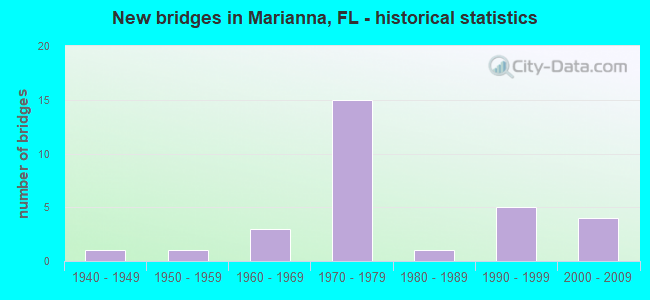
- New bridges - historical statistics
- 11940-1949
- 11950-1959
- 31960-1969
- 151970-1979
- 11980-1989
- 51990-1999
- 42000-2009


- Bridge Condition - Deck
- 36.8%Good
- 63.2%Satisfactory

- Bridge Condition - Superstructure
- 10.5%Very good
- 47.4%Good
- 31.6%Satisfactory
- 5.3%Fair
- 5.3%Poor

- Bridge Condition - Substructure
- 5.3%Very good
- 57.9%Good
- 31.6%Satisfactory
- 5.3%Fair

- Bridge Condition - Channel
- 14.3%Very good
- 28.6%Good
- 42.9%Satisfactory
- 7.1%Fair
- 7.1%Poor

- Bridge Condition - Culverts
- 33.3%Good
- 33.3%Satisfactory
- 33.3%Fair
Find on map >> Show street view
Structure Number: 530005, Location: 0.6Mi. East of SR73 (Lat: 30.773044, Lng: -85.215961), Route carried "on" structure: US 90, Year Built: 1943, Year Reconstructed: 1957, Status: Open, Structure Length: 13.32m (43.70ft), Average Daily Traffic: 22,000 (year 2020), Truck Traffic: 6%, Average Future Daily Traffic: 38,170 (year 2042), Design Load: HS 20, Features Intersected: Chipola River
Minimum Vertical Clearance: 30+ m (98+ ft), Kilometerpoint: 0.972, Lanes on structure: 4, Base Highway Network: Yes, Owner: State Highway Agency, Approaching Roadway Width: 20.7m (67.9ft), Skew: 20 degrees, Material/Design: Concrete, Design/Construction: Tee Beam, Number Of Spans In Main Unit: 3, Number Of Approach Spans: 18, Length of Maximum Span: 12.5m (41.0ft), Curb or Sidewalk Widths: Left: 1.5m (4.9ft), Right: 1.5m (4.9ft), Curb-To-Curb Width: 17.1m (56.1ft), Out-to-Out Width: 20.7m (67.9ft)
Condition: Deck: Satisfactory, Superstructure: Poor, Substructure: Satisfactory, Channel: Good, Operating Rating: 40.8 metric tons, Method Used To Determine Operating Rating: Load Factor (LF), Inventory Rating: 24.5 metric tons, Method Used To Determine Inventory Rating: Load Factor (LF), Structural Evaluation: Meets minimum limits, Deck Geometry: Somewhat better than minimum adequacy, Waterway Adequacy: Equal to present desirable criteria, Approach Roadway Alignment: Equal to present desirable criteria, Designated Inspection Frequency: Every 24 months, Underwater Inspection Frequency: Every 24 months, Other Special Inspection Frequency: Every 12 months, Inspection Date: April 2020, Underwater Inspection Date: April 2020, Other Special Inspection Date: April 2021, Deck Structure Type: Concrete Cast-file-Place, Wearing Surface/Protective System: Wearing Surface: Bituminous
Find on map >> Show street view
Structure Number: 530013, Location: 1.5 Miles North of SR166 (Lat: 30.832992, Lng: -85.208572), Route carried "on" structure: County highway 167, Year Built: 1972, Status: Open, Structure Length: 1.31m (4.30ft), Average Daily Traffic: 2,000 (year 2019), Truck Traffic: 12%, Average Future Daily Traffic: 4,337 (year 2039), Design Load: HS 20, Features Intersected: Unnamed Branch
Minimum Vertical Clearance: 30+ m (98+ ft), Kilometerpoint: 2.464, Lanes on structure: 2, Owner: County Highway Agency, Approaching Roadway Width: 7.3m (24.0ft), Skew: 1 degrees, Material/Design: Concrete, Design/Construction: Culvert, Number Of Spans In Main Unit: 4, Length of Maximum Span: 3.3m (10.8ft)
Condition: Channel: Satisfactory, Culverts: Good, Operating Rating: 69.9 metric tons, Method Used To Determine Operating Rating: Load Factor (LF), Inventory Rating: 41.7 metric tons, Method Used To Determine Inventory Rating: Load Factor (LF), Structural Evaluation: Better than present minimum criteria, Waterway Adequacy: Better than present minimum criteria, Approach Roadway Alignment: Equal to present desirable criteria, Designated Inspection Frequency: Every 24 months, Inspection Date: August 2020
Find on map >> Show street view
Structure Number: 530022, Location: 6.9 Mi East of US231/SR75 (Lat: 30.871233, Lng: -85.255606), Route carried "on" structure: County highway 162, Year Built: 1963, Status: Open, Structure Length: 12.19m (39.99ft), Average Daily Traffic: 1,350 (year 2020), Truck Traffic: 10%, Average Future Daily Traffic: 1,480 (year 2040), Design Load: H 15, Features Intersected: Chipola River
Minimum Vertical Clearance: 30+ m (98+ ft), Kilometerpoint: 11.100, Lanes on structure: 2, Owner: County Highway Agency, Approaching Roadway Width: 7.3m (24.0ft), Material/Design: Concrete, Design/Construction: Slab, Number Of Spans In Main Unit: 16, Length of Maximum Span: 7.6m (24.9ft), Curb or Sidewalk Widths: Left: 0.2m (0.7ft), Right: 0.2m (0.7ft), Curb-To-Curb Width: 7.2m (23.6ft), Out-to-Out Width: 7.9m (25.9ft)
Condition: Deck: Satisfactory, Superstructure: Satisfactory, Substructure: Satisfactory, Channel: Satisfactory, Operating Rating: 49.0 metric tons, Method Used To Determine Operating Rating: Load Factor (LF), Inventory Rating: 29.0 metric tons, Method Used To Determine Inventory Rating: Load Factor (LF), Structural Evaluation: Equal to present minimum criteria, Deck Geometry: High priority of corrective action, Waterway Adequacy: Better than present minimum criteria, Approach Roadway Alignment: Equal to present desirable criteria, Designated Inspection Frequency: Every 24 months, Underwater Inspection Frequency: Every 24 months, Inspection Date: March 2020, Underwater Inspection Date: March 2020, Deck Structure Type: Concrete Cast-file-Place
Find on map >> Show street view
Structure Number: 530025, Location: 1.1 Miles West of SR 71 (Lat: 30.719092, Lng: -85.202569), Route carried "on" structure: County highway 280, Year Built: 1968, Status: Open, Structure Length: 3.05m (10.01ft), Average Daily Traffic: 725 (year 2019), Truck Traffic: 3%, Average Future Daily Traffic: 797 (year 2039), Design Load: HS 20, Features Intersected: Chipola River Relief
Minimum Vertical Clearance: 30+ m (98+ ft), Kilometerpoint: 8.866, Lanes on structure: 2, Owner: County Highway Agency, Approaching Roadway Width: 7.3m (24.0ft), Material/Design: Prestressed concrete, Design/Construction: Stringer/Multi-beam, Number Of Spans In Main Unit: 2, Length of Maximum Span: 15.2m (49.9ft), Curb or Sidewalk Widths: Left: 0.5m (1.6ft), Right: 0.5m (1.6ft), Curb-To-Curb Width: 8.4m (27.6ft), Out-to-Out Width: 10.1m (33.1ft)
Condition: Deck: Good, Superstructure: Good, Substructure: Good, Channel: Satisfactory, Operating Rating: 52.6 metric tons, Method Used To Determine Operating Rating: Load Factor (LF), Inventory Rating: 31.8 metric tons, Method Used To Determine Inventory Rating: Load Factor (LF), Structural Evaluation: Better than present minimum criteria, Deck Geometry: Somewhat better than minimum adequacy, Waterway Adequacy: Equal to present desirable criteria, Approach Roadway Alignment: Equal to present desirable criteria, Designated Inspection Frequency: Every 24 months, Inspection Date: October 2020, Deck Structure Type: Concrete Cast-file-Place
Find on map >> Show street view
Structure Number: 530041, Location: 1.6 Mi South of I10/SR8 (Lat: 30.717497, Lng: -85.200308), Route carried "on" structure: County highway 280, Year Built: 1968, Status: Open, Structure Length: 9.14m (29.99ft), Average Daily Traffic: 472 (year 2019), Truck Traffic: 4%, Average Future Daily Traffic: 519 (year 2039), Design Load: H 20, Features Intersected: Chipola River
Minimum Vertical Clearance: 30+ m (98+ ft), Kilometerpoint: 9.101, Lanes on structure: 2, Owner: County Highway Agency, Approaching Roadway Width: 6.7m (22.0ft), Material/Design: Prestressed concrete, Design/Construction: Stringer/Multi-beam, Number Of Spans In Main Unit: 6, Length of Maximum Span: 15.2m (49.9ft), Curb or Sidewalk Widths: Left: 0.4m (1.3ft), Right: 0.4m (1.3ft), Curb-To-Curb Width: 8.2m (26.9ft), Out-to-Out Width: 10.1m (33.1ft)
Condition: Deck: Satisfactory, Superstructure: Good, Substructure: Fair, Channel: Fair, Operating Rating: 57.2 metric tons, Method Used To Determine Operating Rating: Load Factor (LF), Inventory Rating: 35.4 metric tons, Method Used To Determine Inventory Rating: Load Factor (LF), Structural Evaluation: Somewhat better than minimum adequacy, Deck Geometry: Somewhat better than minimum adequacy, Waterway Adequacy: Equal to present desirable criteria, Approach Roadway Alignment: Equal to present desirable criteria, Designated Inspection Frequency: Every 24 months, Underwater Inspection Frequency: Every 24 months, Inspection Date: Febuary 2021, Underwater Inspection Date: Febuary 2021, Deck Structure Type: Concrete Cast-file-Place
Find on map >> Show street view
Structure Number: 530052, Location: 1.0 Miles West of SR71 (Lat: 30.724622, Lng: -85.200100), Route carried "on" structure: Interstate 10, Year Built: 1976, Status: Open, Structure Length: 9.78m (32.09ft), Average Daily Traffic: 9,850 (year 2020), Truck Traffic: 38%, Average Future Daily Traffic: 17,090 (year 2042), Design Load: HS 20, Features Intersected: Chipola River
Minimum Vertical Clearance: 30+ m (98+ ft), Kilometerpoint: 23.197, Lanes on structure: 2, Base Highway Network: Yes, Owner: State Highway Agency, Approaching Roadway Width: 11.6m (38.1ft), Material/Design: Prestressed concrete, Design/Construction: Stringer/Multi-beam, Number Of Spans In Main Unit: 6, Length of Maximum Span: 16.3m (53.5ft), Curb-To-Curb Width: 11.9m (39.0ft), Out-to-Out Width: 12.9m (42.3ft)
Condition: Deck: Satisfactory, Superstructure: Very good, Substructure: Satisfactory, Channel: Satisfactory, Operating Rating: 77.1 metric tons, Method Used To Determine Operating Rating: Load Factor (LF), Inventory Rating: 46.3 metric tons, Method Used To Determine Inventory Rating: Load Factor (LF), Structural Evaluation: Equal to present minimum criteria, Deck Geometry: Equal to present minimum criteria, Waterway Adequacy: Equal to present desirable criteria, Approach Roadway Alignment: Equal to present desirable criteria, Designated Inspection Frequency: Every 24 months, Underwater Inspection Frequency: Every 24 months, Inspection Date: November 2021, Underwater Inspection Date: November 2021, Deck Structure Type: Concrete Cast-file-Place
Find on map >> Show street view
Structure Number: 530053, Location: 1.0 Miles West of SR71 (Lat: 30.724353, Lng: -85.200000), Route carried "on" structure: Interstate 10, Year Built: 1976, Status: Open, Structure Length: 9.75m (31.99ft), Average Daily Traffic: 9,850 (year 2020), Truck Traffic: 38%, Average Future Daily Traffic: 17,090 (year 2042), Design Load: HS 20, Features Intersected: Chipola River
Minimum Vertical Clearance: 30+ m (98+ ft), Kilometerpoint: 23.197, Lanes on structure: 2, Base Highway Network: Yes, Owner: State Highway Agency, Approaching Roadway Width: 11.6m (38.1ft), Material/Design: Prestressed concrete, Design/Construction: Stringer/Multi-beam, Number Of Spans In Main Unit: 6, Length of Maximum Span: 16.3m (53.5ft), Curb-To-Curb Width: 11.9m (39.0ft), Out-to-Out Width: 12.9m (42.3ft)
Condition: Deck: Satisfactory, Superstructure: Good, Substructure: Satisfactory, Channel: Satisfactory, Operating Rating: 77.1 metric tons, Method Used To Determine Operating Rating: Load Factor (LF), Inventory Rating: 46.3 metric tons, Method Used To Determine Inventory Rating: Load Factor (LF), Structural Evaluation: Equal to present minimum criteria, Deck Geometry: Equal to present minimum criteria, Waterway Adequacy: Equal to present desirable criteria, Approach Roadway Alignment: Equal to present desirable criteria, Designated Inspection Frequency: Every 24 months, Underwater Inspection Frequency: Every 24 months, Inspection Date: November 2021, Underwater Inspection Date: November 2021, Deck Structure Type: Concrete Cast-file-Place
Find on map >> Show street view
Structure Number: 530054, Location: 2.0Mi S of Marianna limit (Lat: 30.732756, Lng: -85.230225), Route carried "on" structure: State highway 73, Year Built: 1975, Status: Open, Structure Length: 8.53m (27.99ft), Average Daily Traffic: 5,000 (year 2020), Truck Traffic: 9%, Average Future Daily Traffic: 8,675 (year 2042), Design Load: HS 20+Mod, Features Intersected: I10 SR8
Minimum Vertical Clearance: 30+ m (98+ ft), Kilometerpoint: 21.287, Lanes on structure: 2, Lanes under structure: 4, Owner: State Highway Agency, Approaching Roadway Width: 10.4m (34.1ft), Skew: 2 degrees, Material/Design: Prestressed concrete, Design/Construction: Stringer/Multi-beam, Number Of Spans In Main Unit: 4, Length of Maximum Span: 30.2m (99.1ft), Curb-To-Curb Width: 13.3m (43.6ft), Out-to-Out Width: 14.1m (46.3ft)
Condition: Deck: Good, Superstructure: Satisfactory, Substructure: Good, Operating Rating: 70.8 metric tons, Method Used To Determine Operating Rating: Load Factor (LF), Inventory Rating: 41.7 metric tons, Method Used To Determine Inventory Rating: Load Factor (LF), Structural Evaluation: Equal to present minimum criteria, Deck Geometry: Equal to present minimum criteria, Underclear: Somewhat better than minimum adequacy, Approach Roadway Alignment: Equal to present desirable criteria, Designated Inspection Frequency: Every 24 months, Inspection Date: June 2021, Deck Structure Type: Concrete Cast-file-Place
Find on map >> Show street view
Structure Number: 530055, Location: 2.87Mi W of SR73 (Lat: 30.753417, Lng: -85.272983), Route carried "on" structure: Interstate 10, Year Built: 1976, Status: Open, Structure Length: 7.30m (23.95ft), Average Daily Traffic: 9,850 (year 2020), Truck Traffic: 38%, Average Future Daily Traffic: 17,090 (year 2042), Design Load: HS 20+Mod, Features Intersected: SR276
Minimum Vertical Clearance: 30+ m (98+ ft), Kilometerpoint: 15.487, Lanes on structure: 2, Lanes under structure: 4, Base Highway Network: Yes, Owner: State Highway Agency, Approaching Roadway Width: 11.6m (38.1ft), Skew: 3 degrees, Material/Design: Prestressed concrete, Design/Construction: Stringer/Multi-beam, Number Of Spans In Main Unit: 4, Length of Maximum Span: 23.3m (76.4ft), Curb-To-Curb Width: 12.2m (40.0ft), Out-to-Out Width: 13.0m (42.7ft)
Condition: Deck: Satisfactory, Superstructure: Satisfactory, Substructure: Good, Operating Rating: 67.5 metric tons, Method Used To Determine Operating Rating: Load Factor (LF), Inventory Rating: 40.5 metric tons, Method Used To Determine Inventory Rating: Load Factor (LF), Structural Evaluation: Equal to present minimum criteria, Deck Geometry: Better than present minimum criteria, Underclear: Equal to present minimum criteria, Approach Roadway Alignment: Equal to present desirable criteria, Designated Inspection Frequency: Every 24 months, Inspection Date: July 2021, Deck Structure Type: Concrete Cast-file-Place
Find on map >> Show street view
Structure Number: 530056, Location: 2.87MI W of SR73 (Lat: 30.753153, Lng: -85.272853), Route carried "on" structure: Interstate 10, Year Built: 1976, Status: Open, Structure Length: 7.29m (23.92ft), Average Daily Traffic: 9,850 (year 2020), Truck Traffic: 38%, Average Future Daily Traffic: 17,090 (year 2042), Design Load: HS 20+Mod, Features Intersected: SR276
Minimum Vertical Clearance: 30+ m (98+ ft), Kilometerpoint: 15.487, Lanes on structure: 2, Lanes under structure: 4, Base Highway Network: Yes, Owner: State Highway Agency, Approaching Roadway Width: 11.6m (38.1ft), Skew: 3 degrees, Material/Design: Prestressed concrete, Design/Construction: Stringer/Multi-beam, Number Of Spans In Main Unit: 4, Length of Maximum Span: 23.4m (76.8ft), Curb-To-Curb Width: 12.2m (40.0ft), Out-to-Out Width: 13.0m (42.7ft)
Condition: Deck: Satisfactory, Superstructure: Fair, Substructure: Good, Operating Rating: 67.5 metric tons, Method Used To Determine Operating Rating: Load Factor (LF), Inventory Rating: 40.5 metric tons, Method Used To Determine Inventory Rating: Load Factor (LF), Structural Evaluation: Somewhat better than minimum adequacy, Deck Geometry: Better than present minimum criteria, Underclear: Better than present minimum criteria, Approach Roadway Alignment: Equal to present desirable criteria, Designated Inspection Frequency: Every 24 months, Inspection Date: July 2021, Deck Structure Type: Concrete Cast-file-Place
Find on map >> Show street view
Structure Number: 530063, Location: 1.5 miles S of US90 SR10 (Lat: 30.736483, Lng: -85.185236), Route carried "on" structure: State highway 71, Year Built: 1980, Status: Open, Structure Length: 5.30m (17.39ft), Average Daily Traffic: 7,750 (year 2020), Truck Traffic: 9%, Average Future Daily Traffic: 13,446 (year 2042), Design Load: HS 20, Features Intersected: FG&A RR
Minimum Vertical Clearance: 30+ m (98+ ft), Kilometerpoint: 14.969, Lanes on structure: 2, Base Highway Network: Yes, Owner: State Highway Agency, Approaching Roadway Width: 7.3m (24.0ft), Skew: 2 degrees, Material/Design: Prestressed concrete continuous, Design/Construction: Stringer/Multi-beam, Number Of Spans In Main Unit: 3, Length of Maximum Span: 17.7m (58.1ft), Curb-To-Curb Width: 12.2m (40.0ft), Out-to-Out Width: 13.4m (44.0ft)
Condition: Deck: Satisfactory, Superstructure: Good, Substructure: Good, Operating Rating: 65.3 metric tons, Method Used To Determine Operating Rating: Load Factor (LF), Inventory Rating: 39.0 metric tons, Method Used To Determine Inventory Rating: Load Factor (LF), Structural Evaluation: Better than present minimum criteria, Deck Geometry: Better than present minimum criteria, Underclear: Equal to present minimum criteria, Approach Roadway Alignment: Equal to present desirable criteria, Designated Inspection Frequency: Every 24 months, Inspection Date: August 2021, Deck Structure Type: Other
Find on map >> Show street view
Structure Number: 530066, Location: 0.9Mi E. of Chipola River (Lat: 30.721525, Lng: -85.185464), Route carried "on" structure: Interstate 10, Year Built: 1976, Status: Open, Structure Length: 6.66m (21.85ft), Average Daily Traffic: 10,000 (year 2020), Truck Traffic: 33%, Average Future Daily Traffic: 17,350 (year 2042), Design Load: HS 20, Features Intersected: SR71
Minimum Vertical Clearance: 30+ m (98+ ft), Kilometerpoint: 24.639, Lanes on structure: 2, Lanes under structure: 5, Base Highway Network: Yes, Owner: State Highway Agency, Approaching Roadway Width: 11.6m (38.1ft), Skew: 1 degrees, Material/Design: Prestressed concrete, Design/Construction: Stringer/Multi-beam, Number Of Spans In Main Unit: 4, Length of Maximum Span: 22.3m (73.2ft), Curb-To-Curb Width: 12.2m (40.0ft), Out-to-Out Width: 13.1m (43.0ft)
Condition: Deck: Satisfactory, Superstructure: Satisfactory, Substructure: Good, Operating Rating: 69.2 metric tons, Method Used To Determine Operating Rating: Load Factor (LF), Inventory Rating: 41.5 metric tons, Method Used To Determine Inventory Rating: Load Factor (LF), Structural Evaluation: Equal to present minimum criteria, Deck Geometry: Better than present minimum criteria, Underclear: Equal to present minimum criteria, Approach Roadway Alignment: Equal to present desirable criteria, Designated Inspection Frequency: Every 24 months, Inspection Date: September 2021, Deck Structure Type: Concrete Cast-file-Place
Find on map >> Show street view
Structure Number: 530067, Location: 0.9Mi E. of Chipola River (Lat: 30.721281, Lng: -85.185528), Route carried "on" structure: Interstate 10, Year Built: 1976, Status: Open, Structure Length: 6.66m (21.85ft), Average Daily Traffic: 10,000 (year 2020), Truck Traffic: 33%, Average Future Daily Traffic: 17,350 (year 2042), Design Load: HS 20, Features Intersected: SR71
Minimum Vertical Clearance: 30+ m (98+ ft), Kilometerpoint: 24.639, Lanes on structure: 2, Lanes under structure: 5, Base Highway Network: Yes, Owner: State Highway Agency, Approaching Roadway Width: 11.6m (38.1ft), Skew: 1 degrees, Material/Design: Prestressed concrete, Design/Construction: Stringer/Multi-beam, Number Of Spans In Main Unit: 4, Length of Maximum Span: 22.3m (73.2ft), Curb-To-Curb Width: 12.2m (40.0ft), Out-to-Out Width: 13.1m (43.0ft)
Condition: Deck: Satisfactory, Superstructure: Good, Substructure: Good, Operating Rating: 69.2 metric tons, Method Used To Determine Operating Rating: Load Factor (LF), Inventory Rating: 41.5 metric tons, Method Used To Determine Inventory Rating: Load Factor (LF), Structural Evaluation: Better than present minimum criteria, Deck Geometry: Better than present minimum criteria, Underclear: Equal to present minimum criteria, Approach Roadway Alignment: Equal to present desirable criteria, Designated Inspection Frequency: Every 24 months, Inspection Date: September 2021, Deck Structure Type: Concrete Cast-file-Place
Find on map >> Show street view
Structure Number: 530085, Location: 0.5 Mi. West of SR276 (Lat: 30.756631, Lng: -85.280453), Route carried "on" structure: County highway , Year Built: 1979, Status: Open, Structure Length: 7.74m (25.39ft), Average Daily Traffic: 2,200 (year 2012), Truck Traffic: 14%, Average Future Daily Traffic: 3,817 (year 2034), Design Load: HS 20, Features Intersected: I10 SR8, Facility Carried by Structure: New Hope Road
Minimum Vertical Clearance: 30+ m (98+ ft), Kilometerpoint: 0.752, Lanes on structure: 2, Lanes under structure: 4, Owner: State Highway Agency, Approaching Roadway Width: 7.3m (24.0ft), Skew: 1 degrees, Material/Design: Prestressed concrete continuous, Design/Construction: Stringer/Multi-beam, Number Of Spans In Main Unit: 2, Length of Maximum Span: 38.7m (127.0ft), Curb-To-Curb Width: 11.0m (36.1ft), Out-to-Out Width: 11.8m (38.7ft)
Condition: Deck: Good, Superstructure: Satisfactory, Substructure: Good, Operating Rating: 45.0 metric tons, Method Used To Determine Operating Rating: Load Factor (LF), Inventory Rating: 34.9 metric tons, Method Used To Determine Inventory Rating: Load Factor (LF), Structural Evaluation: Equal to present minimum criteria, Deck Geometry: Somewhat better than minimum adequacy, Underclear: Somewhat better than minimum adequacy, Approach Roadway Alignment: Equal to present desirable criteria, Designated Inspection Frequency: Every 24 months, Inspection Date: September 2021, Deck Structure Type: Concrete Cast-file-Place
Find on map >> Show street view
Structure Number: 530115, Location: 1.5 Mi S. of US90 (SR10) (Lat: 30.735889, Lng: -85.185389), Route carried "on" structure: State highway 71, Year Built: 1999, Status: Open, Structure Length: 5.30m (17.39ft), Average Daily Traffic: 7,750 (year 2020), Truck Traffic: 9%, Average Future Daily Traffic: 13,446 (year 2042), Design Load: HS 20, Features Intersected: FG&A RR
Minimum Vertical Clearance: 30+ m (98+ ft), Kilometerpoint: 14.969, Lanes on structure: 2, Base Highway Network: Yes, Owner: State Highway Agency, Approaching Roadway Width: 7.3m (24.0ft), Skew: 2 degrees, Material/Design: Prestressed concrete continuous, Design/Construction: Stringer/Multi-beam, Number Of Spans In Main Unit: 3, Length of Maximum Span: 17.7m (58.1ft), Curb or Sidewalk Widths: Left: 2.0m (6.6ft), Right: 0.0m, Curb-To-Curb Width: 8.5m (27.9ft), Out-to-Out Width: 11.5m (37.7ft)
Condition: Deck: Good, Superstructure: Good, Substructure: Good, Operating Rating: 67.9 metric tons, Method Used To Determine Operating Rating: Load Factor (LF), Inventory Rating: 40.7 metric tons, Method Used To Determine Inventory Rating: Load Factor (LF), Structural Evaluation: Better than present minimum criteria, Deck Geometry: High priority of corrective action, Underclear: Equal to present minimum criteria, Approach Roadway Alignment: Equal to present desirable criteria, Designated Inspection Frequency: Every 24 months, Inspection Date: August 2021, Deck Structure Type: Concrete Cast-file-Place
Find on map >> Show street view
Structure Number: 530117, Location: 0.7mi North of I10 SR8 (Lat: 30.730444, Lng: -85.185083), Route carried "on" structure: State highway 71, Year Built: 1999, Status: Open, Structure Length: 1.60m (5.25ft), Average Daily Traffic: 15,500 (year 2020), Truck Traffic: 9%, Average Future Daily Traffic: 26,892 (year 2042), Design Load: HS 20, Features Intersected: Bridge Creek
Minimum Vertical Clearance: 30+ m (98+ ft), Kilometerpoint: 14.389, Lanes on structure: 4, Base Highway Network: Yes, Owner: State Highway Agency, Approaching Roadway Width: 16.5m (54.1ft), Skew: 11 degrees, Material/Design: Concrete, Design/Construction: Culvert, Number Of Spans In Main Unit: 4, Length of Maximum Span: 3.8m (12.5ft)
Condition: Channel: Good, Culverts: Satisfactory, Operating Rating: 72.6 metric tons, Method Used To Determine Operating Rating: Load Factor (LF), Inventory Rating: 43.5 metric tons, Method Used To Determine Inventory Rating: Load Factor (LF), Structural Evaluation: Equal to present minimum criteria, Waterway Adequacy: Superior to present desirable criteria, Approach Roadway Alignment: Equal to present desirable criteria, Designated Inspection Frequency: Every 24 months, Inspection Date: May 2020
Find on map >> Show street view
Structure Number: 53017, Location: 1.4 Mi. N of US90 SR10 (Lat: 30.792939, Lng: -85.221317), Route carried "on" structure: State highway 166, Year Built: 2002, Status: Open, Structure Length: 19.51m (64.01ft), Average Daily Traffic: 9,000 (year 2020), Truck Traffic: 6%, Average Future Daily Traffic: 15,615 (year 2042), Design Load: HS 20, Features Intersected: Chipola River
Minimum Vertical Clearance: 30+ m (98+ ft), Kilometerpoint: 28.125, Lanes on structure: 2, Base Highway Network: Yes, Owner: State Highway Agency, Approaching Roadway Width: 10.4m (34.1ft), Material/Design: Prestressed concrete, Design/Construction: Stringer/Multi-beam, Number Of Spans In Main Unit: 8, Length of Maximum Span: 24.4m (80.1ft), Curb or Sidewalk Widths: Left: 2.0m (6.6ft), Right: 0.0m, Curb-To-Curb Width: 12.2m (40.0ft), Out-to-Out Width: 15.1m (49.5ft)
Condition: Deck: Satisfactory, Superstructure: Good, Substructure: Good, Channel: Good, Operating Rating: 56.1 metric tons, Method Used To Determine Operating Rating: Load Factor (LF), Inventory Rating: 33.7 metric tons, Method Used To Determine Inventory Rating: Load Factor (LF), Structural Evaluation: Better than present minimum criteria, Deck Geometry: Somewhat better than minimum adequacy, Waterway Adequacy: Equal to present desirable criteria, Approach Roadway Alignment: Equal to present desirable criteria, Designated Inspection Frequency: Every 24 months, Underwater Inspection Frequency: Every 24 months, Inspection Date: September 2021, Underwater Inspection Date: September 2021, Deck Structure Type: Concrete Cast-file-Place
Find on map >> Show street view
Structure Number: 530184, Location: 0.5Mi West of SR71 (Lat: 30.753097, Lng: -85.193342), Route carried "on" structure: US 90, Year Built: 2007, Status: Open, Structure Length: 2.74m (8.99ft), Average Daily Traffic: 9,850 (year 2020), Truck Traffic: 8%, Average Future Daily Traffic: 17,090 (year 2042), Design Load: HS 20, Features Intersected: Merritts Mill Pond
Minimum Vertical Clearance: 30+ m (98+ ft), Kilometerpoint: 4.276, Lanes on structure: 2, Base Highway Network: Yes, Owner: State Highway Agency, Approaching Roadway Width: 8.5m (27.9ft), Material/Design: Prestressed concrete, Design/Construction: Stringer/Multi-beam, Number Of Spans In Main Unit: 1, Length of Maximum Span: 27.4m (89.9ft), Curb or Sidewalk Widths: Left: 0.0m, Right: 1.5m (4.9ft), Curb-To-Curb Width: 10.8m (35.4ft), Out-to-Out Width: 13.4m (44.0ft)
Condition: Deck: Good, Superstructure: Good, Substructure: Good, Channel: Very good, Inventory Rating: 56.8 metric tons, Method Used To Determine Inventory Rating: Load Factor (LF), Structural Evaluation: Better than present minimum criteria, Deck Geometry: Somewhat better than minimum adequacy, Waterway Adequacy: Equal to present desirable criteria, Approach Roadway Alignment: Equal to present desirable criteria, Designated Inspection Frequency: Every 24 months, Inspection Date: January 2021, Deck Structure Type: Concrete Cast-file-Place
Find on map >> Show street view
Structure Number: 530185, Location: 0.5Mi W of SR71 (Lat: 30.753189, Lng: -85.193164), Route carried "on" structure: US 90, Year Built: 2006, Status: Open, Structure Length: 2.74m (8.99ft), Average Daily Traffic: 9,850 (year 2020), Truck Traffic: 8%, Average Future Daily Traffic: 17,090 (year 2042), Design Load: HS 20, Features Intersected: Merritts Mill Pond
Minimum Vertical Clearance: 30+ m (98+ ft), Kilometerpoint: 4.276, Lanes on structure: 2, Base Highway Network: Yes, Owner: State Highway Agency, Approaching Roadway Width: 8.5m (27.9ft), Material/Design: Prestressed concrete, Design/Construction: Stringer/Multi-beam, Number Of Spans In Main Unit: 1, Length of Maximum Span: 27.4m (89.9ft), Curb or Sidewalk Widths: Left: 1.5m (4.9ft), Right: 0.0m, Curb-To-Curb Width: 10.7m (35.1ft), Out-to-Out Width: 13.4m (44.0ft)
Condition: Deck: Good, Superstructure: Very good, Substructure: Very good, Channel: Very good, Inventory Rating: 56.8 metric tons, Method Used To Determine Inventory Rating: Load Factor (LF), Structural Evaluation: Equal to present desirable criteria, Deck Geometry: Somewhat better than minimum adequacy, Waterway Adequacy: Equal to present desirable criteria, Approach Roadway Alignment: Equal to present desirable criteria, Designated Inspection Frequency: Every 24 months, Inspection Date: January 2021, Deck Structure Type: Concrete Cast-file-Place
Find on map >> Show street view
Structure Number: 534001, Location: 0.6 Miles West of SR 73 (Lat: 30.725417, Lng: -85.241089), Route carried "on" structure: County highway , Year Built: 1990, Status: Open, Structure Length: 1.02m (3.35ft), Average Daily Traffic: 110 (year 2020), Truck Traffic: 1%, Average Future Daily Traffic: 120 (year 2040), Features Intersected: Long Branch, Facility Carried by Structure: Thompson Road
Minimum Vertical Clearance: 30+ m (98+ ft), Kilometerpoint: 4.947, Lanes on structure: 2, Owner: County Highway Agency, Approaching Roadway Width: 6.9m (22.6ft), Material/Design: Concrete, Design/Construction: Culvert, Number Of Spans In Main Unit: 3, Length of Maximum Span: 3.9m (12.8ft)
Condition: Channel: Poor, Culverts: Fair, Operating Rating: 45.4 metric tons, Method Used To Determine Operating Rating: Field evaluation and documented engineering judgment, Inventory Rating: 32.7 metric tons, Method Used To Determine Inventory Rating: Field evaluation and documented engineering judgment, Structural Evaluation: Somewhat better than minimum adequacy, Waterway Adequacy: Equal to present desirable criteria, Approach Roadway Alignment: Equal to present desirable criteria, Designated Inspection Frequency: Every 24 months, Other Special Inspection Frequency: Every 12 months, Inspection Date: May 2021, Other Special Inspection Date: May 2021
Find on map >> Show street view
Structure Number: 534015, Location: 1.2 Mi W of Bump Nose Rd (Lat: 30.852583, Lng: -85.287100), Route carried "on" structure: Other road , Year Built: 1991, Status: Open, Structure Length: 1.77m (5.81ft), Average Daily Traffic: 44 (year 2020), Average Future Daily Traffic: 48 (year 2040), Design Load: HS 20, Features Intersected: Baker Creek, Facility Carried by Structure: Baker Creek Road
Minimum Vertical Clearance: 30+ m (98+ ft), Kilometerpoint: 5.354, Lanes on structure: 2, Owner: County Highway Agency, Approaching Roadway Width: 5.5m (18.0ft), Material/Design: Concrete, Design/Construction: Channel Beam, Number Of Spans In Main Unit: 2, Length of Maximum Span: 10.4m (34.1ft), Curb-To-Curb Width: 8.6m (28.2ft), Out-to-Out Width: 8.6m (28.2ft)
Condition: Deck: Good, Superstructure: Good, Substructure: Satisfactory, Channel: Satisfactory, Operating Rating: 85.3 metric tons, Method Used To Determine Operating Rating: Load Factor (LF), Inventory Rating: 50.8 metric tons, Method Used To Determine Inventory Rating: Load Factor (LF), Structural Evaluation: Equal to present minimum criteria, Deck Geometry: Better than present minimum criteria, Waterway Adequacy: Better than present minimum criteria, Approach Roadway Alignment: Equal to present desirable criteria, Designated Inspection Frequency: Every 24 months, Underwater Inspection Frequency: Every 24 months, Inspection Date: May 2021, Underwater Inspection Date: May 2021, Deck Structure Type: Concrete Precast Panels
Find on map >> Show street view
Structure Number: 534163, Location: 1.17 Miles South of CR162 (Lat: 30.860839, Lng: -85.265614), Route carried "on" structure: Other road , Year Built: 1995, Status: Open, Structure Length: 4.58m (15.03ft), Average Daily Traffic: 94 (year 2019), Average Future Daily Traffic: 163 (year 2039), Features Intersected: Waddells Mill Creek, Facility Carried by Structure: Bump Nose Road
Minimum Vertical Clearance: 30+ m (98+ ft), Kilometerpoint: 9.658, Lanes on structure: 2, Owner: County Highway Agency, Approaching Roadway Width: 5.8m (19.0ft), Material/Design: Concrete, Design/Construction: Channel Beam, Number Of Spans In Main Unit: 5, Length of Maximum Span: 10.4m (34.1ft), Curb-To-Curb Width: 8.6m (28.2ft), Out-to-Out Width: 9.4m (30.8ft)
Condition: Deck: Satisfactory, Superstructure: Satisfactory, Substructure: Satisfactory, Channel: Good, Operating Rating: 85.3 metric tons, Method Used To Determine Operating Rating: Load Factor (LF), Inventory Rating: 50.8 metric tons, Method Used To Determine Inventory Rating: Load Factor (LF), Structural Evaluation: Equal to present minimum criteria, Deck Geometry: Better than present minimum criteria, Waterway Adequacy: Better than present minimum criteria, Approach Roadway Alignment: Equal to present minimum criteria, Designated Inspection Frequency: Every 24 months, Inspection Date: August 2020, Deck Structure Type: Concrete Precast Panels
Find on map >> Show street view
Structure Number: 530004, Location: 0.1 Mile West of SR73 N. (Lat: 30.785525, Lng: -85.258431), Route carried "under" structure: US 90, Year Built: 1958, Structure Length: 0. m, Average Daily Traffic: 6,100 (year 2018), Truck Traffic: 7%, Features Intersected: US90 SR10, Facility Carried by Structure: FGA RR
Minimum Vertical Clearance: 4.69m (15.39ft), Kilometerpoint: 19.204, Lanes under structure: 4, Material/Design: Steel, Design/Construction: Girder and Floorbeam System, Length of Maximum Span: 22.9m (75.1ft)
Find on map >> Show street view
Structure Number: 530054, Location: 2.0Mi S of Marianna limit (Lat: 30.732756, Lng: -85.230225), Route carried "under" structure: Interstate 10, Year Built: 1975, Structure Length: 0. m, Average Daily Traffic: 19,700 (year 2020), Truck Traffic: 38%, Features Intersected: I10 SR8, Facility Carried by Structure: SR73
Minimum Vertical Clearance: 4.82m (15.81ft), Kilometerpoint: 20.159, Lanes on structure: 2, Lanes under structure: 4, Material/Design: Prestressed concrete, Design/Construction: Stringer/Multi-beam, Length of Maximum Span: 30.2m (99.1ft)
Find on map >> Show street view
Structure Number: 530055, Location: 2.87Mi W of SR73 (Lat: 30.753417, Lng: -85.272983), Route carried "under" structure: State highway 276, Year Built: 1976, Structure Length: 0. m, Average Daily Traffic: 8,700 (year 2020), Truck Traffic: 10%, Features Intersected: SR276, Facility Carried by Structure: I10 SR8
Minimum Vertical Clearance: 4.57m (14.99ft), Kilometerpoint: 11.570, Lanes on structure: 2, Lanes under structure: 4, Material/Design: Prestressed concrete, Design/Construction: Stringer/Multi-beam, Length of Maximum Span: 23.3m (76.4ft)
Find on map >> Show street view
Structure Number: 530056, Location: 2.87MI W of SR73 (Lat: 30.753153, Lng: -85.272853), Route carried "under" structure: State highway 276, Year Built: 1976, Structure Length: 0. m, Average Daily Traffic: 8,700 (year 2020), Truck Traffic: 10%, Features Intersected: SR276, Facility Carried by Structure: I10 SR8
Minimum Vertical Clearance: 4.79m (15.72ft), Kilometerpoint: 11.603, Lanes on structure: 2, Lanes under structure: 4, Material/Design: Prestressed concrete, Design/Construction: Stringer/Multi-beam, Length of Maximum Span: 23.4m (76.8ft)
Find on map >> Show street view
Structure Number: 530066, Location: 0.9Mi E. of Chipola River (Lat: 30.721525, Lng: -85.185464), Route carried "under" structure: State highway 71, Year Built: 1976, Structure Length: 0. m, Average Daily Traffic: 19,000 (year 2020), Truck Traffic: 9%, Features Intersected: SR71, Facility Carried by Structure: I10 SR8
Minimum Vertical Clearance: 4.63m (15.19ft), Kilometerpoint: 13.322, Lanes on structure: 2, Lanes under structure: 5, Material/Design: Prestressed concrete, Design/Construction: Stringer/Multi-beam, Length of Maximum Span: 22.3m (73.2ft)
Find on map >> Show street view
Structure Number: 530067, Location: 0.9Mi E. of Chipola River (Lat: 30.721281, Lng: -85.185528), Route carried "under" structure: State highway 71, Year Built: 1976, Structure Length: 0. m, Average Daily Traffic: 19,000 (year 2020), Truck Traffic: 9%, Features Intersected: SR71, Facility Carried by Structure: I10 SR8
Minimum Vertical Clearance: 4.63m (15.19ft), Kilometerpoint: 13.293, Lanes on structure: 2, Lanes under structure: 5, Material/Design: Prestressed concrete, Design/Construction: Stringer/Multi-beam, Length of Maximum Span: 22.3m (73.2ft)
Find on map >> Show street view
Structure Number: 530085, Location: 0.5 Mi. West of SR276 (Lat: 30.756631, Lng: -85.280453), Route carried "under" structure: Interstate 10, Year Built: 1979, Structure Length: 0. m, Average Daily Traffic: 21,607 (year 2020), Truck Traffic: 30%, Features Intersected: I10 SR8, Facility Carried by Structure: New Hope Road
Minimum Vertical Clearance: 4.91m (16.11ft), Kilometerpoint: 14.693, Lanes on structure: 2, Lanes under structure: 4, Material/Design: Prestressed concrete continuous, Design/Construction: Stringer/Multi-beam, Length of Maximum Span: 38.7m (127.0ft)
Find on map >> Show street view
Structure Number: 539001, Location: 1.0 mi. North of I10 SR8 (Lat: 30.760483, Lng: -85.258764), Route carried "under" structure: State highway 276, Year Built: 2001, Structure Length: 0. m, Average Daily Traffic: 8,700 (year 2020), Truck Traffic: 10%, Features Intersected: SR276, Facility Carried by Structure: PedestrianOverpass
Minimum Vertical Clearance: 4.94m (16.21ft), Kilometerpoint: 13.161, Lanes under structure: 2, Material/Design: Prestressed concrete, Design/Construction: Stringer/Multi-beam, Length of Maximum Span: 26.4m (86.6ft)