Bridge Statistics for Margate, Florida (FL)
Condition, Traffic, Stress, Structural Evaluation, Project Costs
- National Bridge Inventory (NBI) Statistics
- 14Number of bridges
- 148ft / 45.1mTotal length
- 375,351Total average daily traffic
- 16,298Total average daily truck traffic
- National Bridge Inventory (NBI) Registered Bridges for Margate
- No street view available for this location
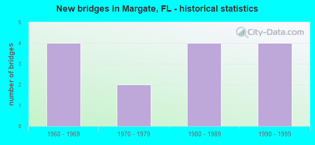
- New bridges - historical statistics
- 41960-1969
- 21970-1979
- 41980-1989
- 41990-1999

- Reconstructed bridges - Historical Statistics
- 11980-1989
- 11990-1999
- 02000-2009
- 12010-2019


- Bridge Condition - Deck
- 81.8%Good
- 18.2%Fair

- Bridge Condition - Superstructure
- 81.8%Good
- 18.2%Fair

- Bridge Condition - Channel
- 63.6%Good
- 18.2%Satisfactory
- 18.2%Fair
Find on map >> Show street view
Structure Number: 860015, Location: SR-7 South of SR-814 (Lat: 26.230628, Lng: -80.204778), Route carried "on" structure: US 441, Year Built: 1963, Year Reconstructed: 1996, Status: Open, Structure Length: 4.39m (14.40ft), Average Daily Traffic: 51,000 (year 2021), Truck Traffic: 3%, Average Future Daily Traffic: 88,485 (year 2042), Design Load: HS 20, Features Intersected: Cypress Creek Canal
Minimum Vertical Clearance: 30+ m (98+ ft), Kilometerpoint: 28.648, Lanes on structure: 6, Base Highway Network: Yes, Owner: State Highway Agency, Approaching Roadway Width: 22.6m (74.1ft), Skew: 20 degrees, Material/Design: Prestressed concrete, Design/Construction: Stringer/Multi-beam, Number Of Spans In Main Unit: 3, Length of Maximum Span: 14.6m (47.9ft), Curb or Sidewalk Widths: Left: 1.5m (4.9ft), Right: 1.5m (4.9ft), Curb-To-Curb Width: 32.3m (106.0ft), Out-to-Out Width: 36.9m (121.1ft)
Condition: Deck: Good, Superstructure: Good, Substructure: Good, Channel: Good, Operating Rating: 52.9 metric tons, Method Used To Determine Operating Rating: Load Factor (LF), Inventory Rating: 41.5 metric tons, Method Used To Determine Inventory Rating: Load Factor (LF), Structural Evaluation: Better than present minimum criteria, Deck Geometry: Superior to present desirable criteria, Waterway Adequacy: Superior to present desirable criteria, Approach Roadway Alignment: Equal to present desirable criteria, Designated Inspection Frequency: Every 24 months, Underwater Inspection Frequency: Every 24 months, Inspection Date: August 2021, Underwater Inspection Date: August 2021, Deck Structure Type: Concrete Cast-file-Place
Find on map >> Show street view
Structure Number: 860593, Location: 2 mi W of Fl. Turnpike (Lat: 26.274297, Lng: -80.201903), Route carried "on" structure: US 441, Year Built: 1993, Status: Open, Structure Length: 6.81m (22.34ft), Average Daily Traffic: 23,000 (year 2020), Truck Traffic: 5%, Average Future Daily Traffic: 39,905 (year 2042), Design Load: HS 20+Mod, Features Intersected: Sample Road
Minimum Vertical Clearance: 30+ m (98+ ft), Kilometerpoint: 33.579, Lanes on structure: 3, Lanes under structure: 8, Base Highway Network: Yes, Owner: State Highway Agency, Approaching Roadway Width: 14.4m (47.2ft), Material/Design: Steel, Design/Construction: Stringer/Multi-beam, Number Of Spans In Main Unit: 1, Length of Maximum Span: 68.1m (223.4ft), Curb-To-Curb Width: 14.4m (47.2ft), Out-to-Out Width: 17.1m (56.1ft)
Condition: Deck: Good, Superstructure: Good, Substructure: Good, Channel: Good, Operating Rating: 53.5 metric tons, Method Used To Determine Operating Rating: Load Factor (LF), Inventory Rating: 32.1 metric tons, Method Used To Determine Inventory Rating: Load Factor (LF), Structural Evaluation: Better than present minimum criteria, Deck Geometry: Somewhat better than minimum adequacy, Underclear: Superior to present desirable criteria, Approach Roadway Alignment: Equal to present desirable criteria, Designated Inspection Frequency: Every 24 months, Inspection Date: September 2021, Deck Structure Type: Concrete Cast-file-Place
Find on map >> Show street view
Structure Number: 860644, Location: 2 mi W of Fl. Turnpike (Lat: 26.273983, Lng: -80.201717), Route carried "on" structure: US 441, Year Built: 1993, Status: Open, Structure Length: 6.81m (22.34ft), Average Daily Traffic: 23,000 (year 2020), Truck Traffic: 5%, Average Future Daily Traffic: 39,905 (year 2042), Design Load: HS 20+Mod, Features Intersected: Sample Road
Minimum Vertical Clearance: 30+ m (98+ ft), Kilometerpoint: 33.579, Lanes on structure: 3, Lanes under structure: 8, Base Highway Network: Yes, Owner: State Highway Agency, Approaching Roadway Width: 14.4m (47.2ft), Material/Design: Steel, Design/Construction: Stringer/Multi-beam, Number Of Spans In Main Unit: 1, Length of Maximum Span: 68.1m (223.4ft), Curb-To-Curb Width: 14.4m (47.2ft), Out-to-Out Width: 17.1m (56.1ft)
Condition: Deck: Good, Superstructure: Good, Substructure: Good, Operating Rating: 53.5 metric tons, Method Used To Determine Operating Rating: Load Factor (LF), Inventory Rating: 32.1 metric tons, Method Used To Determine Inventory Rating: Load Factor (LF), Structural Evaluation: Better than present minimum criteria, Deck Geometry: Somewhat better than minimum adequacy, Underclear: Superior to present desirable criteria, Approach Roadway Alignment: Equal to present desirable criteria, Designated Inspection Frequency: Every 24 months, Inspection Date: September 2021, Deck Structure Type: Concrete Cast-file-Place
Find on map >> Show street view
Structure Number: 864074, Location: 0.8MI WEST OF US-441 (Lat: 26.235369, Lng: -80.217350), Route carried "on" structure: County highway 814, Year Built: 1980, Status: Open, Structure Length: 0.73m (2.40ft), Average Daily Traffic: 40,400 (year 2021), Truck Traffic: 5%, Average Future Daily Traffic: 70,094 (year 2042), Design Load: HS 20, Features Intersected: ONE MILE CANAL, Facility Carried by Structure: W ATLANTIC BLVD
Minimum Vertical Clearance: 30+ m (98+ ft), Kilometerpoint: 0.435, Lanes on structure: 7, Base Highway Network: Yes, Owner: County Highway Agency, Approaching Roadway Width: 28.8m (94.5ft), Skew: 20 degrees, Material/Design: Aluminum, Iron, Design/Construction: Culvert, Number Of Spans In Main Unit: 1, Length of Maximum Span: 7.3m (24.0ft), Curb or Sidewalk Widths: Left: 1.5m (4.9ft), Right: 1.5m (4.9ft)
Condition: Channel: Good, Culverts: Satisfactory, Operating Rating: 58.1 metric tons, Method Used To Determine Operating Rating: Load Factor (LF), Inventory Rating: 34.5 metric tons, Method Used To Determine Inventory Rating: Load Factor (LF), Structural Evaluation: Equal to present minimum criteria, Waterway Adequacy: Equal to present desirable criteria, Approach Roadway Alignment: Equal to present desirable criteria, Designated Inspection Frequency: Every 24 months, Underwater Inspection Frequency: Every 24 months, Inspection Date: June 2021, Underwater Inspection Date: June 2021
Find on map >> Show street view
Structure Number: 864089, Location: 0.1MI S OF ATLANTIC BLVD. (Lat: 26.230692, Lng: -80.184222), Route carried "on" structure: County highway , Year Built: 1985, Status: Open, Structure Length: 5.33m (17.49ft), Average Daily Traffic: 13,200 (year 2021), Truck Traffic: 5%, Average Future Daily Traffic: 15,840 (year 2042), Design Load: HS 20, Features Intersected: CYPRESS CREEK CANAL C-14, Facility Carried by Structure: LYONS RD. SB
Minimum Vertical Clearance: 30+ m (98+ ft), Kilometerpoint: 3.235, Lanes on structure: 3, Owner: County Highway Agency, Approaching Roadway Width: 12.3m (40.4ft), Skew: 9 degrees, Material/Design: Prestressed concrete, Design/Construction: Stringer/Multi-beam, Number Of Spans In Main Unit: 3, Length of Maximum Span: 18.2m (59.7ft), Curb or Sidewalk Widths: Left: 2.3m (7.5ft), Right: 0.0m, Curb-To-Curb Width: 12.6m (41.3ft), Out-to-Out Width: 15.8m (51.8ft)
Condition: Deck: Good, Superstructure: Good, Substructure: Good, Channel: Satisfactory, Operating Rating: 37.2 metric tons, Method Used To Determine Operating Rating: Load Factor (LF), Inventory Rating: 22.5 metric tons, Method Used To Determine Inventory Rating: Load Factor (LF), Structural Evaluation: Somewhat better than minimum adequacy, Deck Geometry: Meets minimum limits, Waterway Adequacy: Equal to present desirable criteria, Approach Roadway Alignment: Better than present minimum criteria, Designated Inspection Frequency: Every 24 months, Underwater Inspection Frequency: Every 24 months, Inspection Date: May 2021, Underwater Inspection Date: May 2021, Deck Structure Type: Concrete Cast-file-Place
Find on map >> Show street view
Structure Number: 86409, Location: 0.1MI S OF ATLANTIC BLVD (Lat: 26.230692, Lng: -80.183992), Route carried "on" structure: County highway , Year Built: 1985, Status: Open, Structure Length: 5.33m (17.49ft), Average Daily Traffic: 32,956 (year 2021), Truck Traffic: 5%, Average Future Daily Traffic: 39,547 (year 2042), Design Load: HS 20, Features Intersected: CYPRESS CREEK CANAL C-14, Facility Carried by Structure: LYONS RD. NB
Minimum Vertical Clearance: 30+ m (98+ ft), Kilometerpoint: 3.235, Lanes on structure: 3, Owner: County Highway Agency, Approaching Roadway Width: 13.3m (43.6ft), Skew: 9 degrees, Material/Design: Prestressed concrete, Design/Construction: Stringer/Multi-beam, Number Of Spans In Main Unit: 3, Length of Maximum Span: 18.2m (59.7ft), Curb-To-Curb Width: 13.3m (43.6ft), Out-to-Out Width: 13.9m (45.6ft)
Condition: Deck: Good, Superstructure: Good, Substructure: Good, Channel: Satisfactory, Operating Rating: 40.5 metric tons, Method Used To Determine Operating Rating: Load Factor (LF), Inventory Rating: 24.1 metric tons, Method Used To Determine Inventory Rating: Load Factor (LF), Structural Evaluation: Somewhat better than minimum adequacy, Deck Geometry: Somewhat better than minimum adequacy, Waterway Adequacy: Equal to present desirable criteria, Approach Roadway Alignment: Better than present minimum criteria, Designated Inspection Frequency: Every 24 months, Underwater Inspection Frequency: Every 24 months, Inspection Date: May 2021, Underwater Inspection Date: May 2021, Deck Structure Type: Concrete Cast-file-Place
Find on map >> Show street view
Structure Number: 864091, Location: 0.1MI S OF ATLANTIC BLVD. (Lat: 26.230717, Lng: -80.183658), Route carried "on" structure: Ramp County highway , Year Built: 1985, Status: Open, Structure Length: 4.65m (15.26ft), Average Daily Traffic: 8,190 (year 2021), Truck Traffic: 5%, Average Future Daily Traffic: 9,828 (year 2042), Design Load: HS 20, Features Intersected: CYPRESS CREEK CANAL C-14, Facility Carried by Structure: LYONS ROAD RAMP
Minimum Vertical Clearance: 30+ m (98+ ft), Kilometerpoint: 0.032, Lanes on structure: 1, Owner: County Highway Agency, Approaching Roadway Width: 6.2m (20.3ft), Material/Design: Prestressed concrete, Design/Construction: Stringer/Multi-beam, Number Of Spans In Main Unit: 3, Length of Maximum Span: 15.5m (50.9ft), Curb or Sidewalk Widths: Left: 0.0m, Right: 2.3m (7.5ft), Curb-To-Curb Width: 6.2m (20.3ft), Out-to-Out Width: 9.3m (30.5ft)
Condition: Deck: Good, Superstructure: Good, Substructure: Good, Channel: Good, Operating Rating: 38.2 metric tons, Method Used To Determine Operating Rating: Load Factor (LF), Inventory Rating: 22.9 metric tons, Method Used To Determine Inventory Rating: Load Factor (LF), Structural Evaluation: Somewhat better than minimum adequacy, Deck Geometry: Somewhat better than minimum adequacy, Waterway Adequacy: Equal to present desirable criteria, Approach Roadway Alignment: Better than present minimum criteria, Designated Inspection Frequency: Every 24 months, Underwater Inspection Frequency: Every 24 months, Inspection Date: May 2021, Underwater Inspection Date: May 2021, Deck Structure Type: Concrete Cast-file-Place
Find on map >> Show street view
Structure Number: 867305, Location: 0.2MI N OF W ALANTIC BLV (Lat: 26.238156, Lng: -80.226789), Route carried "on" structure: City street , Year Built: 1972, Status: Open, Structure Length: 1.71m (5.61ft), Average Daily Traffic: 9,225 (year 2021), Truck Traffic: 5%, Average Future Daily Traffic: 15,615 (year 2042), Design Load: H 15, Features Intersected: RIPPLE CANAL, Facility Carried by Structure: NW 76 AVENUE
Minimum Vertical Clearance: 30+ m (98+ ft), Kilometerpoint: 0.000, Lanes on structure: 2, Owner: City or Municipal Highway Agency, Approaching Roadway Width: 8.0m (26.2ft), Material/Design: Concrete, Design/Construction: Slab, Number Of Spans In Main Unit: 3, Length of Maximum Span: 6.7m (22.0ft), Curb or Sidewalk Widths: Left: 1.2m (3.9ft), Right: 1.2m (3.9ft), Curb-To-Curb Width: 8.0m (26.2ft), Out-to-Out Width: 11.1m (36.4ft)
Condition: Deck: Good, Superstructure: Good, Substructure: Good, Channel: Good, Operating Rating: 43.2 metric tons, Method Used To Determine Operating Rating: Load Factor (LF), Inventory Rating: 25.9 metric tons, Method Used To Determine Inventory Rating: Load Factor (LF), Structural Evaluation: Equal to present minimum criteria, Deck Geometry: High priority of replacement, Waterway Adequacy: Equal to present desirable criteria, Approach Roadway Alignment: Equal to present desirable criteria, Designated Inspection Frequency: Every 24 months, Underwater Inspection Frequency: Every 24 months, Inspection Date: July 2021, Underwater Inspection Date: July 2021, Deck Structure Type: Concrete Precast Panels, Wearing Surface/Protective System: Wearing Surface: Bituminous
Find on map >> Show street view
Structure Number: 867309, Location: 0.2MI S OF ROYAL PALM (Lat: 26.251203, Lng: -80.205956), Route carried "on" structure: City street , Year Built: 1965, Status: Posted for load-capacity, Structure Length: 1.83m (6.00ft), Average Daily Traffic: 1,335 (year 2021), Truck Traffic: 2%, Average Future Daily Traffic: 2,316 (year 2042), Features Intersected: TROPIC CANAL, Facility Carried by Structure: NW 61ST AVE
Minimum Vertical Clearance: 30+ m (98+ ft), Kilometerpoint: 0.126, Lanes on structure: 2, Owner: City or Municipal Highway Agency, Approaching Roadway Width: 7.9m (25.9ft), Material/Design: Prestressed concrete, Design/Construction: Slab, Number Of Spans In Main Unit: 2, Length of Maximum Span: 9.1m (29.9ft), Curb or Sidewalk Widths: Left: 1.3m (4.3ft), Right: 1.3m (4.3ft), Curb-To-Curb Width: 7.9m (25.9ft), Out-to-Out Width: 10.6m (34.8ft)
Condition: Deck: Fair, Superstructure: Fair, Substructure: Good, Channel: Fair, Operating Rating: 54.2 metric tons, Method Used To Determine Operating Rating: Load Factor (LF), Inventory Rating: 32.6 metric tons, Method Used To Determine Inventory Rating: Load Factor (LF), Structural Evaluation: Somewhat better than minimum adequacy, Deck Geometry: Meets minimum limits, Waterway Adequacy: Better than present minimum criteria, Approach Roadway Alignment: Equal to present desirable criteria, Designated Inspection Frequency: Every 24 months, Underwater Inspection Frequency: Every 24 months, Inspection Date: July 2021, Underwater Inspection Date: July 2021, Deck Structure Type: Concrete Precast Panels, Wearing Surface/Protective System: Wearing Surface: Bituminous
Find on map >> Show street view
Structure Number: 86731, Location: 0.15MI W OF SR-7 (US-441) (Lat: 26.254700, Lng: -80.204119), Route carried "on" structure: City street , Year Built: 1965, Year Reconstructed: 2010, Status: Open, Structure Length: 1.85m (6.07ft), Average Daily Traffic: 21,000 (year 2021), Truck Traffic: 6%, Average Future Daily Traffic: 25,200 (year 2042), Features Intersected: MARGATE CANAL, Facility Carried by Structure: ROYAL PALM BLVD
Minimum Vertical Clearance: 30+ m (98+ ft), Kilometerpoint: 3.355, Lanes on structure: 4, Owner: City or Municipal Highway Agency, Approaching Roadway Width: 15.7m (51.5ft), Skew: 20 degrees, Material/Design: Prestressed concrete, Design/Construction: Slab, Number Of Spans In Main Unit: 3, Length of Maximum Span: 9.2m (30.2ft), Curb-To-Curb Width: 15.7m (51.5ft), Out-to-Out Width: 22.0m (72.2ft)
Condition: Deck: Fair, Superstructure: Fair, Substructure: Good, Channel: Fair, Operating Rating: 66.0 metric tons, Method Used To Determine Operating Rating: Load Factor (LF), Inventory Rating: 39.6 metric tons, Method Used To Determine Inventory Rating: Load Factor (LF), Structural Evaluation: Somewhat better than minimum adequacy, Deck Geometry: Meets minimum limits, Waterway Adequacy: Better than present minimum criteria, Approach Roadway Alignment: Equal to present desirable criteria, Designated Inspection Frequency: Every 24 months, Underwater Inspection Frequency: Every 24 months, Inspection Date: July 2021, Underwater Inspection Date: July 2021, Deck Structure Type: Concrete Precast Panels, Wearing Surface/Protective System: Wearing Surface: Integral Concrete
Find on map >> Show street view
Structure Number: 867312, Location: 0.2MI N OF ROYAL PALM (Lat: 26.257228, Lng: -80.210447), Route carried "on" structure: City street , Year Built: 1962, Status: Open, Structure Length: 1.80m (5.91ft), Average Daily Traffic: 545 (year 2021), Truck Traffic: 2%, Average Future Daily Traffic: 645 (year 2042), Design Load: H 15, Features Intersected: HOGANS CREEK, Facility Carried by Structure: NW 63RD AVE
Minimum Vertical Clearance: 30+ m (98+ ft), Kilometerpoint: 0.000, Lanes on structure: 2, Owner: City or Municipal Highway Agency, Approaching Roadway Width: 7.4m (24.3ft), Material/Design: Concrete, Design/Construction: Slab, Number Of Spans In Main Unit: 3, Length of Maximum Span: 6.1m (20.0ft), Curb or Sidewalk Widths: Left: 1.0m (3.3ft), Right: 1.0m (3.3ft), Curb-To-Curb Width: 7.4m (24.3ft), Out-to-Out Width: 10.5m (34.4ft)
Condition: Deck: Good, Superstructure: Good, Substructure: Good, Channel: Good, Operating Rating: 45.4 metric tons, Method Used To Determine Operating Rating: Load Factor (LF), Inventory Rating: 27.2 metric tons, Method Used To Determine Inventory Rating: Load Factor (LF), Structural Evaluation: Equal to present minimum criteria, Deck Geometry: Meets minimum limits, Waterway Adequacy: Better than present minimum criteria, Approach Roadway Alignment: Equal to present desirable criteria, Designated Inspection Frequency: Every 24 months, Underwater Inspection Frequency: Every 24 months, Inspection Date: July 2021, Underwater Inspection Date: July 2021, Deck Structure Type: Concrete Precast Panels, Wearing Surface/Protective System: Wearing Surface: Bituminous
Find on map >> Show street view
Structure Number: 867313, Location: 0.2M S OF W ALANTIC BLVD. (Lat: 26.230253, Lng: -80.221472), Route carried "on" structure: City street , Year Built: 1978, Year Reconstructed: 1993, Status: Open, Structure Length: 3.90m (12.80ft), Average Daily Traffic: 27,500 (year 2021), Truck Traffic: 6%, Average Future Daily Traffic: 33,000 (year 2042), Design Load: HS 20, Features Intersected: POMPANO CANAL C-14, Facility Carried by Structure: ROCK ISLAND ROAD
Minimum Vertical Clearance: 30+ m (98+ ft), Kilometerpoint: 7.358, Lanes on structure: 5, Owner: City or Municipal Highway Agency, Approaching Roadway Width: 17.1m (56.1ft), Skew: 20 degrees, Material/Design: Prestressed concrete, Design/Construction: Slab, Number Of Spans In Main Unit: 5, Length of Maximum Span: 8.5m (27.9ft), Curb or Sidewalk Widths: Left: 1.6m (5.2ft), Right: 1.8m (5.9ft), Curb-To-Curb Width: 24.0m (78.7ft), Out-to-Out Width: 31.7m (104.0ft)
Condition: Deck: Good, Superstructure: Good, Substructure: Good, Channel: Good, Operating Rating: 79.3 metric tons, Method Used To Determine Operating Rating: Load Factor (LF), Inventory Rating: 47.6 metric tons, Method Used To Determine Inventory Rating: Load Factor (LF), Structural Evaluation: Better than present minimum criteria, Deck Geometry: Equal to present desirable criteria, Waterway Adequacy: Better than present minimum criteria, Approach Roadway Alignment: Better than present minimum criteria, Designated Inspection Frequency: Every 24 months, Underwater Inspection Frequency: Every 24 months, Inspection Date: July 2021, Underwater Inspection Date: July 2021, Deck Structure Type: Concrete Precast Panels, Wearing Surface/Protective System: Wearing Surface: Bituminous
Find on map >> Show street view
Structure Number: 860593, Location: 2 mi W of Fl. Turnpike (Lat: 26.274297, Lng: -80.201903), Route carried "under" structure: State highway 834, Year Built: 1993, Structure Length: 0. m, Average Daily Traffic: 60,500 (year 2020), Truck Traffic: 4%, Features Intersected: Sample Road, Facility Carried by Structure: SB US-441/SR-7
Minimum Vertical Clearance: 5.15m (16.90ft), Kilometerpoint: 4.851, Lanes on structure: 3, Lanes under structure: 8, Material/Design: Steel, Design/Construction: Stringer/Multi-beam, Length of Maximum Span: 68.1m (223.4ft)
Find on map >> Show street view
Structure Number: 860644, Location: 2 mi W of Fl. Turnpike (Lat: 26.273983, Lng: -80.201717), Route carried "under" structure: State highway 834, Year Built: 1993, Structure Length: 0. m, Average Daily Traffic: 63,500 (year 2008), Truck Traffic: 3%, Features Intersected: Sample Road, Facility Carried by Structure: NB US-441(SR-7)
Minimum Vertical Clearance: 5.15m (16.90ft), Kilometerpoint: 4.851, Lanes on structure: 3, Lanes under structure: 8, Material/Design: Steel, Design/Construction: Stringer/Multi-beam, Length of Maximum Span: 68.1m (223.4ft)