Bridge Statistics for Maplewood, Minnesota (MN)
Condition, Traffic, Stress, Structural Evaluation, Project Costs
- National Bridge Inventory (NBI) Statistics
- 40Number of bridges
- 279ft / 85.1mTotal length
- $3,328,998,000Total costs
- 989,456Total average daily traffic
- 34,789Total average daily truck traffic
- National Bridge Inventory (NBI) Registered Bridges for Maplewood
- No street view available for this location
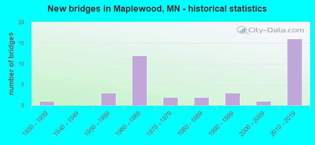
- New bridges - historical statistics
- 11930-1939
- 31950-1959
- 121960-1969
- 21970-1979
- 21980-1989
- 31990-1999
- 12000-2009
- 162010-2019


- Bridge Condition - Deck
- 31.8%Very good
- 27.3%Good
- 36.4%Satisfactory
- 4.5%Fair

- Bridge Condition - Superstructure
- 4.3%Excellent
- 26.1%Very good
- 30.4%Good
- 34.8%Satisfactory
- 4.3%Fair

- Bridge Condition - Substructure
- 26.1%Very good
- 39.1%Good
- 21.7%Satisfactory
- 13.0%Fair

- Bridge Condition - Channel
- 16.7%Excellent
- 83.3%Satisfactory
Find on map >> Show street view
Structure Number: 62004, Location: 0.6 MI E OF JCT TH61 (Lat: 45.011719, Lng: -93.042389), Route carried "on" structure: , Year Built: 2013, Status: Open, Structure Length: 6.13m (20.11ft), Features Intersected: TH 36; RAMPS, Facility Carried by Structure: PEDESTRIAN
Lanes under structure: 8, Owner: State Highway Agency, Skew: 1 degrees, Material/Design: Prestressed concrete, Design/Construction: Stringer/Multi-beam, Number Of Spans In Main Unit: 2, Length of Maximum Span: 29.9m (98.1ft), Out-to-Out Width: 4.4m (14.4ft)
Condition: Deck: Very good, Superstructure: Very good, Substructure: Good, Underclear: High priority of corrective action, Bridge Posting: Required (Relationship of Operating Rating to Maximum Legal Load: > 39.9% below), Designated Inspection Frequency: Every 24 months, Inspection Date: May 2020, Deck Structure Type: Concrete Cast-file-Place, Wearing Surface/Protective System: Wearing Surface: Monolithic Concrete, Deck Protection: Epoxy Coated Reinforcing
Find on map >> Show street view
Structure Number: 62006, Location: 0.7 MI E OF JCT TH 35E (Lat: 45.009619, Lng: -93.076339), Route carried "on" structure: County highway 58, Year Built: 1969, Status: Open, Structure Length: 4.83m (15.85ft), Average Daily Traffic: 6,800 (year 2013), Average Future Daily Traffic: 6,800 (year 2039), Design Load: HS 20, Features Intersected: TH 36
Minimum Vertical Clearance: 30+ m (98+ ft), Kilometerpoint: 0.000, Lanes on structure: 4, Lanes under structure: 4, Owner: State Highway Agency, Approaching Roadway Width: 12.5m (41.0ft), Material/Design: Steel continuous, Design/Construction: Stringer/Multi-beam, Number Of Spans In Main Unit: 3, Length of Maximum Span: 30.8m (101.0ft), Curb or Sidewalk Widths: Left: 2.4m (7.9ft), Right: 2.4m (7.9ft), Curb-To-Curb Width: 15.9m (52.2ft), Out-to-Out Width: 21.5m (70.5ft)
Condition: Deck: Satisfactory, Superstructure: Satisfactory, Substructure: Fair, Operating Rating: 72.2 metric tons, Method Used To Determine Operating Rating: Load Factor (LF), Inventory Rating: 43.1 metric tons, Method Used To Determine Inventory Rating: Load Factor (LF), Structural Evaluation: Somewhat better than minimum adequacy, Deck Geometry: Meets minimum limits, Underclear: High priority of corrective action, Approach Roadway Alignment: Better than present minimum criteria, Length Of Structure Improvement: 1.62m (5.31ft), Designated Inspection Frequency: Every 24 months, Inspection Date: August 2021, Bridge Improvement Cost: $999,999,000, Roadway Improvement Cost: $69,000,000, Total Project Cost: $999,999,000, Deck Structure Type: Concrete Cast-file-Place, Wearing Surface/Protective System: Wearing Surface: Low Slump Concrete
Find on map >> Show street view
Structure Number: 62007, Location: 1.2 MI E OF JCT TH 35E (Lat: 45.010575, Lng: -93.066156), Route carried "on" structure: City street 125, Year Built: 1968, Status: Open, Structure Length: 5.86m (19.23ft), Average Daily Traffic: 1,400 (year 2017), Average Future Daily Traffic: 1,400 (year 2039), Design Load: HS 20, Features Intersected: TH 36
Minimum Vertical Clearance: 30+ m (98+ ft), Kilometerpoint: 0.000, Lanes on structure: 2, Lanes under structure: 4, Owner: State Highway Agency, Approaching Roadway Width: 11.0m (36.1ft), Skew: 2 degrees, Material/Design: Steel continuous, Design/Construction: Stringer/Multi-beam, Number Of Spans In Main Unit: 3, Length of Maximum Span: 33.4m (109.6ft), Curb or Sidewalk Widths: Left: 1.5m (4.9ft), Right: 0.0m, Curb-To-Curb Width: 11.0m (36.1ft), Out-to-Out Width: 13.6m (44.6ft)
Condition: Deck: Satisfactory, Superstructure: Satisfactory, Substructure: Satisfactory, Operating Rating: 65.3 metric tons, Method Used To Determine Operating Rating: Load Factor (LF), Inventory Rating: 39.2 metric tons, Method Used To Determine Inventory Rating: Load Factor (LF), Structural Evaluation: Equal to present minimum criteria, Deck Geometry: Equal to present minimum criteria, Underclear: High priority of corrective action, Approach Roadway Alignment: Equal to present desirable criteria, Length Of Structure Improvement: 1.95m (6.40ft), Designated Inspection Frequency: Every 24 months, Inspection Date: August 2021, Bridge Improvement Cost: $999,999,000, Roadway Improvement Cost: $84,000,000, Total Project Cost: $999,999,000, Deck Structure Type: Concrete Cast-file-Place, Wearing Surface/Protective System: Wearing Surface: Low Slump Concrete
Find on map >> Show street view
Structure Number: 62037, Location: 0.4 MI W OF JCT TH 61 (Lat: 45.011478, Lng: -93.062814), Route carried "on" structure: State highway 36, Year Built: 2013, Status: Open, Structure Length: 3.60m (11.81ft), Average Daily Traffic: 56,000 (year 2019), Truck Traffic: 2%, Average Future Daily Traffic: 66,000 (year 2039), Design Load: HL 93, Features Intersected: KELLER LAKE
Minimum Vertical Clearance: 30+ m (98+ ft), Kilometerpoint: 0.000, Lanes on structure: 4, Base Highway Network: Yes, Owner: State Highway Agency, Approaching Roadway Width: 20.7m (67.9ft), Skew: 30 degrees, Material/Design: Prestressed concrete, Design/Construction: Tee Beam, Number Of Spans In Main Unit: 3, Length of Maximum Span: 14.2m (46.6ft), Curb-To-Curb Width: 25.5m (83.7ft), Out-to-Out Width: 27.4m (89.9ft)
Condition: Deck: Very good, Superstructure: Very good, Substructure: Good, Channel: Satisfactory, Operating Rating: 64.2 metric tons, Method Used To Determine Operating Rating: Load and Resistance Factor Rating (LRFR) rating reported by rating factor(RF) method using HL-93 loadings, Inventory Rating: 42.8 metric tons, Method Used To Determine Inventory Rating: Load and Resistance Factor Rating (LRFR) rating reported by rating factor(RF) method using HL-93 loadings, Structural Evaluation: Better than present minimum criteria, Deck Geometry: Superior to present desirable criteria, Waterway Adequacy: Equal to present desirable criteria, Approach Roadway Alignment: Equal to present desirable criteria, Designated Inspection Frequency: Every 24 months, Inspection Date: May 2020, Deck Structure Type: Concrete Cast-file-Place, Wearing Surface/Protective System: Wearing Surface: Epoxy Overlay, Deck Protection: Epoxy Coated Reinforcing
Find on map >> Show street view
Structure Number: 62067, Location: 0.5 MI E OF JCT TH61 (Lat: 45.011761, Lng: -93.045906), Route carried "on" structure: City street 104, Year Built: 2013, Status: Open, Structure Length: 4.03m (13.22ft), Average Daily Traffic: 3,300 (year 2017), Average Future Daily Traffic: 3,300 (year 2039), Design Load: HL 93, Features Intersected: TH 36
Minimum Vertical Clearance: 30+ m (98+ ft), Kilometerpoint: 0.000, Lanes on structure: 4, Lanes under structure: 4, Owner: State Highway Agency, Approaching Roadway Width: 12.2m (40.0ft), Material/Design: Prestressed concrete, Design/Construction: Stringer/Multi-beam, Number Of Spans In Main Unit: 2, Length of Maximum Span: 19.4m (63.6ft), Curb or Sidewalk Widths: Left: 2.4m (7.9ft), Right: 0.0m, Curb-To-Curb Width: 18.9m (62.0ft), Out-to-Out Width: 22.2m (72.8ft)
Condition: Deck: Good, Superstructure: Very good, Substructure: Good, Operating Rating: 48.0 metric tons, Method Used To Determine Operating Rating: Load and Resistance Factor Rating (LRFR) rating reported by rating factor(RF) method using HL-93 loadings, Inventory Rating: 35.6 metric tons, Method Used To Determine Inventory Rating: Load and Resistance Factor Rating (LRFR) rating reported by rating factor(RF) method using HL-93 loadings, Structural Evaluation: Better than present minimum criteria, Deck Geometry: Equal to present minimum criteria, Underclear: Meets minimum limits, Approach Roadway Alignment: Equal to present desirable criteria, Designated Inspection Frequency: Every 24 months, Inspection Date: May 2020, Deck Structure Type: Concrete Cast-file-Place, Wearing Surface/Protective System: Wearing Surface: Low Slump Concrete, Deck Protection: Epoxy Coated Reinforcing
Find on map >> Show street view
Structure Number: 6207, Location: 2.8 MI N OF JCT TH 60 (Lat: 44.320667, Lng: -92.410881), Route carried "on" structure: US 63, Year Built: 1938, Status: Open, Structure Length: 0.67m (2.20ft), Average Daily Traffic: 2,642 (year 2019), Truck Traffic: 4%, Average Future Daily Traffic: 2,650 (year 2039), Design Load: H 15, Features Intersected: STREAM
Minimum Vertical Clearance: 30+ m (98+ ft), Kilometerpoint: 0.000, Lanes on structure: 2, Base Highway Network: Yes, Owner: State Highway Agency, Approaching Roadway Width: 9.8m (32.2ft), Material/Design: Concrete, Design/Construction: Culvert, Number Of Spans In Main Unit: 2, Length of Maximum Span: 3.0m (9.8ft)
Condition: Channel: Satisfactory, Culverts: Satisfactory, Operating Rating: 39.2 metric tons, Method Used To Determine Operating Rating: Assigned ratings based on Allowable Stress Design (ASD) reported in metric tons, Inventory Rating: 26.1 metric tons, Method Used To Determine Inventory Rating: Assigned ratings based on Allowable Stress Design (ASD) reported in metric tons, Structural Evaluation: Equal to present minimum criteria, Waterway Adequacy: Equal to present desirable criteria, Approach Roadway Alignment: Equal to present desirable criteria, Length Of Structure Improvement: 0.34m (1.12ft), Designated Inspection Frequency: Every 24 months, Inspection Date: July 2020, Bridge Improvement Cost: $77,000,000, Roadway Improvement Cost: $3,000,000, Total Project Cost: $46,000,000
Find on map >> Show street view
Structure Number: 6207, Location: AT JCT TH 36; 61 (Lat: 45.011769, Lng: -93.055017), Route carried "on" structure: State highway 36, Year Built: 1970, Status: Open, Structure Length: 5.27m (17.29ft), Average Daily Traffic: 66,000 (year 2019), Truck Traffic: 3%, Average Future Daily Traffic: 68,000 (year 2039), Design Load: HS 20, Features Intersected: US 61
Minimum Vertical Clearance: 30+ m (98+ ft), Kilometerpoint: 0.000, Lanes on structure: 6, Lanes under structure: 6, Base Highway Network: Yes, Owner: State Highway Agency, Approaching Roadway Width: 35.7m (117.1ft), Skew: 32 degrees, Material/Design: Prestressed concrete, Design/Construction: Stringer/Multi-beam, Number Of Spans In Main Unit: 2, Length of Maximum Span: 25.6m (84.0ft), Curb-To-Curb Width: 25.5m (83.7ft), Out-to-Out Width: 28.6m (93.8ft)
Condition: Deck: Satisfactory, Superstructure: Satisfactory, Substructure: Fair, Operating Rating: 71.5 metric tons, Method Used To Determine Operating Rating: Load Factor (LF), Inventory Rating: 25.9 metric tons, Method Used To Determine Inventory Rating: Load Factor (LF), Structural Evaluation: Somewhat better than minimum adequacy, Deck Geometry: Meets minimum limits, Underclear: Meets minimum limits, Approach Roadway Alignment: Equal to present desirable criteria, Designated Inspection Frequency: Every 24 months, Inspection Date: August 2021, Deck Structure Type: Concrete Cast-file-Place, Wearing Surface/Protective System: Wearing Surface: Low Slump Concrete
Find on map >> Show street view
Structure Number: 62537, Location: 0.2 MI NE OF JCT CSAH 23 (Lat: 45.022728, Lng: -93.064039), Route carried "on" structure: County highway 22, Year Built: 1982, Status: Open, Structure Length: 2.30m (7.55ft), Average Daily Traffic: 2,100 (year 2015), Average Future Daily Traffic: 2,100 (year 2039), Design Load: HS 20, Features Intersected: KOHLMAN CREEK
Minimum Vertical Clearance: 30+ m (98+ ft), Kilometerpoint: 0.000, Lanes on structure: 2, Owner: County Highway Agency, Approaching Roadway Width: 11.0m (36.1ft), Material/Design: Concrete continuous, Design/Construction: Slab, Number Of Spans In Main Unit: 3, Length of Maximum Span: 7.9m (25.9ft), Curb or Sidewalk Widths: Left: 0.0m, Right: 1.8m (5.9ft), Curb-To-Curb Width: 11.0m (36.1ft), Out-to-Out Width: 14.1m (46.3ft)
Condition: Deck: Fair, Superstructure: Fair, Substructure: Good, Channel: Satisfactory, Operating Rating: 61.4 metric tons, Method Used To Determine Operating Rating: Load Factor (LF), Inventory Rating: 37.2 metric tons, Method Used To Determine Inventory Rating: Load Factor (LF), Structural Evaluation: Somewhat better than minimum adequacy, Deck Geometry: Somewhat better than minimum adequacy, Waterway Adequacy: Equal to present desirable criteria, Approach Roadway Alignment: Equal to present minimum criteria, Designated Inspection Frequency: Every 24 months, Inspection Date: November 2021, Deck Structure Type: Concrete Cast-file-Place, Wearing Surface/Protective System: Wearing Surface: Low Slump Concrete, Deck Protection: Epoxy Coated Reinforcing
Find on map >> Show street view
Structure Number: 62543, Location: 0.3MI N OF JCT CSAH 31 (Lat: 44.981122, Lng: -93.004350), Route carried "on" structure: County highway 68, Year Built: 1988, Status: Open, Structure Length: 5.74m (18.83ft), Average Daily Traffic: 12,600 (year 2016), Average Future Daily Traffic: 12,600 (year 2039), Design Load: HS 20, Features Intersected: UP RR
Minimum Vertical Clearance: 30+ m (98+ ft), Kilometerpoint: 0.000, Lanes on structure: 4, Owner: County Highway Agency, Approaching Roadway Width: 17.1m (56.1ft), Skew: 2 degrees, Material/Design: Prestressed concrete, Design/Construction: Stringer/Multi-beam, Number Of Spans In Main Unit: 3, Length of Maximum Span: 24.8m (81.4ft), Curb or Sidewalk Widths: Left: 3.0m (9.8ft), Right: 1.8m (5.9ft), Curb-To-Curb Width: 17.1m (56.1ft), Out-to-Out Width: 24.4m (80.1ft)
Condition: Deck: Good, Superstructure: Good, Substructure: Satisfactory, Operating Rating: 37.6 metric tons, Method Used To Determine Operating Rating: Load Factor (LF), Inventory Rating: 22.5 metric tons, Method Used To Determine Inventory Rating: Load Factor (LF), Structural Evaluation: Somewhat better than minimum adequacy, Deck Geometry: Somewhat better than minimum adequacy, Underclear: Somewhat better than minimum adequacy, Approach Roadway Alignment: Equal to present minimum criteria, Designated Inspection Frequency: Every 24 months, Inspection Date: October 2021, Deck Structure Type: Concrete Cast-file-Place, Wearing Surface/Protective System: Wearing Surface: Low Slump Concrete, Deck Protection: Epoxy Coated Reinforcing
Find on map >> Show street view
Structure Number: 62554, Location: 0.4 MI E OF JCT TH 35E (Lat: 44.991903, Lng: -93.080458), Route carried "on" structure: County highway 30, Year Built: 1992, Status: Open, Structure Length: 1.17m (3.84ft), Average Daily Traffic: 10,600 (year 2015), Average Future Daily Traffic: 10,600 (year 2039), Design Load: HS 25 or greater, Features Intersected: DNR TRAIL
Minimum Vertical Clearance: 30+ m (98+ ft), Kilometerpoint: 0.000, Lanes on structure: 2, Owner: County Highway Agency, Approaching Roadway Width: 15.9m (52.2ft), Skew: 4 degrees, Material/Design: Concrete, Design/Construction: Frame, Number Of Spans In Main Unit: 1, Length of Maximum Span: 10.2m (33.5ft), Curb-To-Curb Width: 15.9m (52.2ft), Out-to-Out Width: 24.7m (81.0ft)
Condition: Deck: Satisfactory, Superstructure: Good, Substructure: Good, Operating Rating: 99.6 metric tons, Method Used To Determine Operating Rating: Load Factor (LF), Inventory Rating: 68.1 metric tons, Method Used To Determine Inventory Rating: Load Factor (LF), Structural Evaluation: Better than present minimum criteria, Deck Geometry: Superior to present desirable criteria, Approach Roadway Alignment: Better than present minimum criteria, Designated Inspection Frequency: Every 24 months, Inspection Date: October 2021, Deck Structure Type: Concrete Cast-file-Place, Wearing Surface/Protective System: Wearing Surface: Bituminous, Deck Protection: Epoxy Coated Reinforcing
Find on map >> Show street view
Structure Number: 62559, Location: 0.2 MI E OF JCT TH 49 (Lat: 44.999108, Lng: -93.102286), Route carried "on" structure: City street 138, Year Built: 1992, Status: Open, Structure Length: 4.91m (16.11ft), Average Daily Traffic: 5,100 (year 2017), Average Future Daily Traffic: 5,100 (year 2039), Design Load: HS 25 or greater, Features Intersected: CP RAIL
Minimum Vertical Clearance: 30+ m (98+ ft), Kilometerpoint: 0.000, Lanes on structure: 2, Owner: City or Municipal Highway Agency, Approaching Roadway Width: 12.2m (40.0ft), Skew: 2 degrees, Material/Design: Prestressed concrete, Design/Construction: Stringer/Multi-beam, Number Of Spans In Main Unit: 3, Length of Maximum Span: 17.6m (57.7ft), Curb or Sidewalk Widths: Left: 1.8m (5.9ft), Right: 0.0m, Curb-To-Curb Width: 13.4m (44.0ft), Out-to-Out Width: 16.1m (52.8ft)
Condition: Deck: Satisfactory, Superstructure: Good, Substructure: Very good, Operating Rating: 63.0 metric tons, Method Used To Determine Operating Rating: Load Factor (LF), Inventory Rating: 37.9 metric tons, Method Used To Determine Inventory Rating: Load Factor (LF), Structural Evaluation: Better than present minimum criteria, Deck Geometry: Equal to present minimum criteria, Underclear: Better than present minimum criteria, Approach Roadway Alignment: Better than present minimum criteria, Designated Inspection Frequency: Every 24 months, Inspection Date: October 2021, Deck Structure Type: Concrete Cast-file-Place, Wearing Surface/Protective System: Wearing Surface: Monolithic Concrete, Deck Protection: Epoxy Coated Reinforcing
Find on map >> Show street view
Structure Number: 62563, Location: 0.6 MI E OF JCT TH 61 (Lat: 45.020886, Lng: -93.040147), Route carried "on" structure: County highway 23, Year Built: 1993, Status: Open, Structure Length: 1.58m (5.18ft), Average Daily Traffic: 5,400 (year 2012), Average Future Daily Traffic: 5,400 (year 2039), Design Load: HS 25 or greater, Features Intersected: REC TRAIL
Minimum Vertical Clearance: 30+ m (98+ ft), Kilometerpoint: 0.000, Lanes on structure: 2, Owner: County Highway Agency, Approaching Roadway Width: 13.4m (44.0ft), Skew: 1 degrees, Material/Design: Concrete, Design/Construction: Slab, Number Of Spans In Main Unit: 1, Length of Maximum Span: 14.2m (46.6ft), Curb or Sidewalk Widths: Left: 0.0m, Right: 1.8m (5.9ft), Curb-To-Curb Width: 13.4m (44.0ft), Out-to-Out Width: 16.1m (52.8ft)
Condition: Deck: Good, Superstructure: Good, Substructure: Good, Operating Rating: 68.6 metric tons, Method Used To Determine Operating Rating: Load Factor (LF), Inventory Rating: 41.2 metric tons, Method Used To Determine Inventory Rating: Load Factor (LF), Structural Evaluation: Better than present minimum criteria, Deck Geometry: Equal to present minimum criteria, Approach Roadway Alignment: Better than present minimum criteria, Designated Inspection Frequency: Every 24 months, Inspection Date: September 2021, Deck Structure Type: Concrete Cast-file-Place, Wearing Surface/Protective System: Wearing Surface: Low Slump Concrete, Deck Protection: Epoxy Coated Reinforcing
Find on map >> Show street view
Structure Number: 6257, Location: 0.1 MI SW OF JCT CSAH 22 (Lat: 45.014439, Lng: -93.065544), Route carried "on" structure: City street 125, Year Built: 2003, Status: Open, Structure Length: 1.53m (5.02ft), Average Daily Traffic: 1,450 (year 2014), Average Future Daily Traffic: 1,450 (year 2039), Design Load: HS 25 or greater, Features Intersected: KELLER CANAL
Minimum Vertical Clearance: 30+ m (98+ ft), Kilometerpoint: 0.000, Lanes on structure: 2, Owner: City or Municipal Highway Agency, Approaching Roadway Width: 10.4m (34.1ft), Material/Design: Concrete, Design/Construction: Arch - Deck, Number Of Spans In Main Unit: 1, Length of Maximum Span: 13.4m (44.0ft), Curb or Sidewalk Widths: Left: 2.3m (7.5ft), Right: 2.3m (7.5ft), Curb-To-Curb Width: 10.4m (34.1ft), Out-to-Out Width: 15.3m (50.2ft)
Condition: Superstructure: Good, Substructure: Very good, Channel: Satisfactory, Operating Rating: 53.9 metric tons, Method Used To Determine Operating Rating: Field evaluation and documented engineering judgment, Inventory Rating: 35.9 metric tons, Method Used To Determine Inventory Rating: Field evaluation and documented engineering judgment, Structural Evaluation: Better than present minimum criteria, Deck Geometry: Equal to present minimum criteria, Waterway Adequacy: Equal to present desirable criteria, Approach Roadway Alignment: Equal to present minimum criteria, Designated Inspection Frequency: Every 24 months, Inspection Date: October 2020, Deck Structure Type: Concrete Cast-file-Place, Wearing Surface/Protective System: Wearing Surface: Bituminous
Find on map >> Show street view
Structure Number: 62643, Location: 0.3 MI E OF JCT TH61 (Lat: 44.997333, Lng: -93.062553), Route carried "on" structure: City street 151, Year Built: 2011, Status: Open, Structure Length: 3.35m (10.99ft), Average Daily Traffic: 7,300 (year 2017), Average Future Daily Traffic: 7,300 (year 2039), Design Load: HL 93, Features Intersected: PHALEN/KELLER RVR; TRL
Minimum Vertical Clearance: 30+ m (98+ ft), Kilometerpoint: 0.000, Lanes on structure: 2, Owner: City or Municipal Highway Agency, Approaching Roadway Width: 11.0m (36.1ft), Skew: 3 degrees, Material/Design: Prestressed concrete, Design/Construction: Stringer/Multi-beam, Number Of Spans In Main Unit: 1, Length of Maximum Span: 33.5m (109.9ft), Curb or Sidewalk Widths: Left: 0.0m, Right: 3.7m (12.1ft), Curb-To-Curb Width: 11.0m (36.1ft), Out-to-Out Width: 15.5m (50.9ft)
Condition: Deck: Very good, Superstructure: Excellent, Substructure: Very good, Channel: Excellent, Operating Rating: 45.4 metric tons, Method Used To Determine Operating Rating: Load and Resistance Factor Rating (LRFR) rating reported by rating factor(RF) method using HL-93 loadings, Inventory Rating: 35.6 metric tons, Method Used To Determine Inventory Rating: Load and Resistance Factor Rating (LRFR) rating reported by rating factor(RF) method using HL-93 loadings, Structural Evaluation: Equal to present desirable criteria, Deck Geometry: Meets minimum limits, Waterway Adequacy: Equal to present desirable criteria, Approach Roadway Alignment: Better than present minimum criteria, Designated Inspection Frequency: Every 24 months, Inspection Date: November 2020, Deck Structure Type: Concrete Cast-file-Place, Wearing Surface/Protective System: Wearing Surface: Low Slump Concrete, Deck Protection: Epoxy Coated Reinforcing
Find on map >> Show street view
Structure Number: 62929, Location: 0.8 MI S OF JCT TH 36 (Lat: 44.999039, Lng: -93.089644), Route carried "on" structure: Interstate 35E, Year Built: 2015, Status: Open, Structure Length: 2.12m (6.96ft), Average Daily Traffic: 65,000 (year 2017), Truck Traffic: 5%, Average Future Daily Traffic: 65,000 (year 2039), Design Load: HL 93, Features Intersected: ROSELAWN AVE
Minimum Vertical Clearance: 30+ m (98+ ft), Kilometerpoint: 0.000, Lanes on structure: 4, Lanes under structure: 2, Base Highway Network: Yes, Owner: State Highway Agency, Approaching Roadway Width: 19.7m (64.6ft), Material/Design: Prestressed concrete, Design/Construction: Stringer/Multi-beam, Number Of Spans In Main Unit: 1, Length of Maximum Span: 20.1m (65.9ft), Curb-To-Curb Width: 19.7m (64.6ft), Out-to-Out Width: 20.6m (67.6ft)
Condition: Deck: Very good, Superstructure: Very good, Substructure: Very good, Operating Rating: 49.9 metric tons, Method Used To Determine Operating Rating: Load and Resistance Factor Rating (LRFR) rating reported by rating factor(RF) method using HL-93 loadings, Inventory Rating: 36.6 metric tons, Method Used To Determine Inventory Rating: Load and Resistance Factor Rating (LRFR) rating reported by rating factor(RF) method using HL-93 loadings, Structural Evaluation: Equal to present desirable criteria, Deck Geometry: Equal to present minimum criteria, Underclear: Better than present minimum criteria, Approach Roadway Alignment: Equal to present desirable criteria, Designated Inspection Frequency: Every 24 months, Inspection Date: June 2020, Deck Structure Type: Concrete Cast-file-Place, Wearing Surface/Protective System: Wearing Surface: Monolithic Concrete, Deck Protection: Epoxy Coated Reinforcing
Find on map >> Show street view
Structure Number: 6293, Location: 0.8 MI S OF JCT TH 36 (Lat: 44.999017, Lng: -93.089386), Route carried "on" structure: Interstate 35E, Year Built: 2014, Status: Open, Structure Length: 2.12m (6.96ft), Average Daily Traffic: 68,000 (year 2019), Truck Traffic: 5%, Average Future Daily Traffic: 65,000 (year 2039), Design Load: HL 93, Features Intersected: ROSELAWN AVE
Minimum Vertical Clearance: 30+ m (98+ ft), Kilometerpoint: 0.000, Lanes on structure: 4, Lanes under structure: 2, Base Highway Network: Yes, Owner: State Highway Agency, Approaching Roadway Width: 21.1m (69.2ft), Material/Design: Prestressed concrete, Design/Construction: Stringer/Multi-beam, Number Of Spans In Main Unit: 1, Length of Maximum Span: 20.1m (65.9ft), Curb-To-Curb Width: 21.0m (68.9ft), Out-to-Out Width: 21.9m (71.9ft)
Condition: Deck: Very good, Superstructure: Very good, Substructure: Good, Operating Rating: 60.9 metric tons, Method Used To Determine Operating Rating: Load and Resistance Factor Rating (LRFR) rating reported by rating factor(RF) method using HL-93 loadings, Inventory Rating: 39.9 metric tons, Method Used To Determine Inventory Rating: Load and Resistance Factor Rating (LRFR) rating reported by rating factor(RF) method using HL-93 loadings, Structural Evaluation: Better than present minimum criteria, Deck Geometry: Better than present minimum criteria, Underclear: Better than present minimum criteria, Approach Roadway Alignment: Equal to present desirable criteria, Designated Inspection Frequency: Every 24 months, Inspection Date: June 2020, Deck Structure Type: Concrete Cast-file-Place, Wearing Surface/Protective System: Wearing Surface: Monolithic Concrete, Deck Protection: Epoxy Coated Reinforcing
Find on map >> Show street view
Structure Number: 62931, Location: 0.3 MI S OF JCT TH 36 (Lat: 45.006275, Lng: -93.089753), Route carried "on" structure: Interstate 35E, Year Built: 2015, Status: Open, Structure Length: 2.12m (6.96ft), Average Daily Traffic: 65,000 (year 2017), Truck Traffic: 5%, Average Future Daily Traffic: 65,000 (year 2039), Design Load: HL 93, Features Intersected: COUNTY ROAD B
Minimum Vertical Clearance: 30+ m (98+ ft), Kilometerpoint: 0.000, Lanes on structure: 5, Lanes under structure: 2, Base Highway Network: Yes, Owner: State Highway Agency, Approaching Roadway Width: 22.1m (72.5ft), Material/Design: Prestressed concrete, Design/Construction: Stringer/Multi-beam, Number Of Spans In Main Unit: 1, Length of Maximum Span: 20.1m (65.9ft), Curb-To-Curb Width: 22.1m (72.5ft), Out-to-Out Width: 23.0m (75.5ft)
Condition: Deck: Very good, Superstructure: Very good, Substructure: Very good, Operating Rating: 55.1 metric tons, Method Used To Determine Operating Rating: Load and Resistance Factor Rating (LRFR) rating reported by rating factor(RF) method using HL-93 loadings, Inventory Rating: 40.5 metric tons, Method Used To Determine Inventory Rating: Load and Resistance Factor Rating (LRFR) rating reported by rating factor(RF) method using HL-93 loadings, Structural Evaluation: Equal to present desirable criteria, Deck Geometry: Meets minimum limits, Underclear: Equal to present minimum criteria, Approach Roadway Alignment: Equal to present desirable criteria, Designated Inspection Frequency: Every 24 months, Inspection Date: June 2020, Deck Structure Type: Concrete Cast-file-Place, Wearing Surface/Protective System: Wearing Surface: Monolithic Concrete, Deck Protection: Epoxy Coated Reinforcing
Find on map >> Show street view
Structure Number: 62932, Location: 0.3 MI S OF JCT TH 36 (Lat: 45.006261, Lng: -93.089517), Route carried "on" structure: Interstate 35E, Year Built: 2014, Status: Open, Structure Length: 2.12m (6.96ft), Average Daily Traffic: 68,000 (year 2019), Truck Traffic: 5%, Average Future Daily Traffic: 65,000 (year 2039), Design Load: HL 93, Features Intersected: COUNTY ROAD B
Minimum Vertical Clearance: 30+ m (98+ ft), Kilometerpoint: 0.000, Lanes on structure: 4, Lanes under structure: 2, Base Highway Network: Yes, Owner: State Highway Agency, Approaching Roadway Width: 20.2m (66.3ft), Material/Design: Prestressed concrete, Design/Construction: Stringer/Multi-beam, Number Of Spans In Main Unit: 1, Length of Maximum Span: 20.1m (65.9ft), Curb-To-Curb Width: 19.7m (64.6ft), Out-to-Out Width: 20.6m (67.6ft)
Condition: Deck: Very good, Superstructure: Good, Substructure: Very good, Operating Rating: 59.3 metric tons, Method Used To Determine Operating Rating: Load and Resistance Factor Rating (LRFR) rating reported by rating factor(RF) method using HL-93 loadings, Inventory Rating: 36.3 metric tons, Method Used To Determine Inventory Rating: Load and Resistance Factor Rating (LRFR) rating reported by rating factor(RF) method using HL-93 loadings, Structural Evaluation: Better than present minimum criteria, Deck Geometry: Equal to present minimum criteria, Underclear: Equal to present minimum criteria, Approach Roadway Alignment: Equal to present desirable criteria, Designated Inspection Frequency: Every 24 months, Inspection Date: June 2020, Deck Structure Type: Concrete Cast-file-Place, Wearing Surface/Protective System: Wearing Surface: Monolithic Concrete, Deck Protection: Epoxy Coated Reinforcing
Find on map >> Show street view
Structure Number: 6692, Location: 1.2 MI SW OF JCT TH 36 (Lat: 44.996222, Lng: -93.065986), Route carried "on" structure: US 61, Year Built: 1951, Status: Open, Structure Length: 3.60m (11.81ft), Average Daily Traffic: 19,100 (year 2019), Truck Traffic: 1%, Average Future Daily Traffic: 19,300 (year 2039), Design Load: HS 20, Features Intersected: PED-BIKE TRAIL
Minimum Vertical Clearance: 30+ m (98+ ft), Kilometerpoint: 0.000, Lanes on structure: 4, Owner: State Highway Agency, Approaching Roadway Width: 23.8m (78.1ft), Skew: 22 degrees, Material/Design: Concrete, Design/Construction: Slab, Number Of Spans In Main Unit: 5, Length of Maximum Span: 7.6m (24.9ft), Curb or Sidewalk Widths: Left: 1.5m (4.9ft), Right: 1.5m (4.9ft), Curb-To-Curb Width: 17.9m (58.7ft), Out-to-Out Width: 20.8m (68.2ft)
Condition: Deck: Satisfactory, Superstructure: Satisfactory, Substructure: Fair, Operating Rating: 34.7 metric tons, Method Used To Determine Operating Rating: Allowable Stress (AS), Inventory Rating: 22.0 metric tons, Method Used To Determine Inventory Rating: Allowable Stress (AS), Structural Evaluation: Somewhat better than minimum adequacy, Deck Geometry: Somewhat better than minimum adequacy, Approach Roadway Alignment: Equal to present desirable criteria, Length Of Structure Improvement: 1.31m (4.30ft), Designated Inspection Frequency: Every 24 months, Inspection Date: June 2020, Bridge Improvement Cost: $999,999,000, Roadway Improvement Cost: $59,000,000, Total Project Cost: $891,000,000, Deck Structure Type: Concrete Cast-file-Place, Wearing Surface/Protective System: Wearing Surface: Low Slump Concrete
Find on map >> Show street view
Structure Number: 6693, Location: 0.9 MI SW OF JCT TH 36 (Lat: 45.000328, Lng: -93.064194), Route carried "on" structure: US 61, Year Built: 1951, Status: Open, Structure Length: 4.41m (14.47ft), Average Daily Traffic: 23,900 (year 2019), Truck Traffic: 1%, Average Future Daily Traffic: 24,000 (year 2039), Design Load: HS 20, Features Intersected: CHANNEL
Minimum Vertical Clearance: 30+ m (98+ ft), Kilometerpoint: 0.000, Lanes on structure: 4, Owner: State Highway Agency, Approaching Roadway Width: 18.6m (61.0ft), Skew: 23 degrees, Material/Design: Prestressed concrete, Design/Construction: Stringer/Multi-beam, Number Of Spans In Main Unit: 3, Length of Maximum Span: 17.8m (58.4ft), Curb-To-Curb Width: 19.5m (64.0ft), Out-to-Out Width: 21.7m (71.2ft)
Condition: Deck: Good, Superstructure: Good, Substructure: Satisfactory, Channel: Satisfactory, Operating Rating: 52.1 metric tons, Method Used To Determine Operating Rating: Load Factor (LF), Inventory Rating: 31.2 metric tons, Method Used To Determine Inventory Rating: Load Factor (LF), Structural Evaluation: Equal to present minimum criteria, Deck Geometry: Better than present minimum criteria, Waterway Adequacy: Superior to present desirable criteria, Approach Roadway Alignment: Equal to present desirable criteria, Designated Inspection Frequency: Every 24 months, Inspection Date: June 2020, Deck Structure Type: Concrete Cast-file-Place, Wearing Surface/Protective System: Wearing Surface: Low Slump Concrete, Deck Protection: Epoxy Coated Reinforcing
Find on map >> Show street view
Structure Number: 9143, Location: AT THE JCT TH 120; 94 (Lat: 44.948494, Lng: -92.985894), Route carried "on" structure: Interstate 94, Year Built: 1962, Status: Open, Structure Length: 5.11m (16.77ft), Average Daily Traffic: 31,500 (year 2017), Truck Traffic: 4%, Average Future Daily Traffic: 31,500 (year 2039), Design Load: HS 20, Features Intersected: TH 120
Minimum Vertical Clearance: 30+ m (98+ ft), Kilometerpoint: 0.000, Lanes on structure: 3, Lanes under structure: 4, Base Highway Network: Yes, Owner: State Highway Agency, Approaching Roadway Width: 15.9m (52.2ft), Skew: 1 degrees, Material/Design: Steel continuous, Design/Construction: Stringer/Multi-beam, Number Of Spans In Main Unit: 2, Length of Maximum Span: 24.7m (81.0ft), Curb-To-Curb Width: 16.0m (52.5ft), Out-to-Out Width: 16.9m (55.4ft)
Condition: Deck: Good, Superstructure: Satisfactory, Substructure: Good, Operating Rating: 59.8 metric tons, Method Used To Determine Operating Rating: Load Factor (LF), Inventory Rating: 35.7 metric tons, Method Used To Determine Inventory Rating: Load Factor (LF), Structural Evaluation: Equal to present minimum criteria, Deck Geometry: Equal to present minimum criteria, Underclear: Meets minimum limits, Approach Roadway Alignment: Equal to present desirable criteria, Length Of Structure Improvement: 1.71m (5.61ft), Designated Inspection Frequency: Every 24 months, Inspection Date: September 2021, Bridge Improvement Cost: $999,999,000, Roadway Improvement Cost: $13,000,000, Total Project Cost: $196,000,000, Deck Structure Type: Concrete Cast-file-Place, Wearing Surface/Protective System: Wearing Surface: Monolithic Concrete, Deck Protection: Epoxy Coated Reinforcing
Find on map >> Show street view
Structure Number: 9144, Location: AT THE JCT TH 120; 94 (Lat: 44.948339, Lng: -92.985825), Route carried "on" structure: Interstate 94, Year Built: 1962, Status: Open, Structure Length: 5.11m (16.77ft), Average Daily Traffic: 41,500 (year 2019), Truck Traffic: 3%, Average Future Daily Traffic: 31,500 (year 2039), Design Load: HS 20, Features Intersected: TH 120
Minimum Vertical Clearance: 30+ m (98+ ft), Kilometerpoint: 0.000, Lanes on structure: 3, Lanes under structure: 4, Base Highway Network: Yes, Owner: State Highway Agency, Approaching Roadway Width: 16.2m (53.1ft), Skew: 1 degrees, Material/Design: Steel continuous, Design/Construction: Stringer/Multi-beam, Number Of Spans In Main Unit: 2, Length of Maximum Span: 24.7m (81.0ft), Curb-To-Curb Width: 16.0m (52.5ft), Out-to-Out Width: 16.9m (55.4ft)
Condition: Deck: Good, Superstructure: Satisfactory, Substructure: Good, Operating Rating: 59.8 metric tons, Method Used To Determine Operating Rating: Load Factor (LF), Inventory Rating: 35.7 metric tons, Method Used To Determine Inventory Rating: Load Factor (LF), Structural Evaluation: Equal to present minimum criteria, Deck Geometry: Equal to present minimum criteria, Underclear: Meets minimum limits, Approach Roadway Alignment: Equal to present desirable criteria, Length Of Structure Improvement: 1.71m (5.61ft), Designated Inspection Frequency: Every 24 months, Inspection Date: September 2021, Bridge Improvement Cost: $999,999,000, Roadway Improvement Cost: $13,000,000, Total Project Cost: $196,000,000, Deck Structure Type: Concrete Cast-file-Place, Wearing Surface/Protective System: Wearing Surface: Monolithic Concrete, Deck Protection: Epoxy Coated Reinforcing
Find on map >> Show street view
Structure Number: 9881, Location: 1.2 MI N OF JCT TH 61 (Lat: 44.901825, Lng: -92.994444), Route carried "on" structure: Interstate 494, Year Built: 1960, Year Reconstructed: 2003, Status: Open, Structure Length: 3.71m (12.17ft), Average Daily Traffic: 42,000 (year 2019), Truck Traffic: 8%, Average Future Daily Traffic: 45,500 (year 2039), Design Load: HS 20, Features Intersected: CSAH 43 (CARVER AVE)
Minimum Vertical Clearance: 30+ m (98+ ft), Kilometerpoint: 0.000, Lanes on structure: 3, Lanes under structure: 2, Base Highway Network: Yes, Owner: State Highway Agency, Approaching Roadway Width: 18.3m (60.0ft), Skew: 1 degrees, Material/Design: Prestressed concrete, Design/Construction: Stringer/Multi-beam, Number Of Spans In Main Unit: 3, Length of Maximum Span: 15.0m (49.2ft), Curb-To-Curb Width: 19.7m (64.6ft), Out-to-Out Width: 20.6m (67.6ft)
Condition: Deck: Satisfactory, Superstructure: Satisfactory, Substructure: Satisfactory, Operating Rating: 91.4 metric tons, Method Used To Determine Operating Rating: Load Factor (LF), Inventory Rating: 57.1 metric tons, Method Used To Determine Inventory Rating: Load Factor (LF), Structural Evaluation: Equal to present minimum criteria, Deck Geometry: Superior to present desirable criteria, Underclear: Somewhat better than minimum adequacy, Approach Roadway Alignment: Equal to present desirable criteria, Designated Inspection Frequency: Every 24 months, Inspection Date: August 2021, Deck Structure Type: Concrete Cast-file-Place, Wearing Surface/Protective System: Wearing Surface: Low Slump Concrete, Deck Protection: Epoxy Coated Reinforcing
Find on map >> Show street view
Structure Number: 9882, Location: 1.2 MI N OF JCT TH 61 (Lat: 44.901742, Lng: -92.994156), Route carried "on" structure: Interstate 494, Year Built: 1960, Year Reconstructed: 2003, Status: Open, Structure Length: 3.71m (12.17ft), Average Daily Traffic: 42,000 (year 2019), Truck Traffic: 8%, Average Future Daily Traffic: 45,500 (year 2039), Design Load: HS 20, Features Intersected: CSAH 43 (CARVER AVE)
Minimum Vertical Clearance: 30+ m (98+ ft), Kilometerpoint: 0.000, Lanes on structure: 3, Lanes under structure: 2, Base Highway Network: Yes, Owner: State Highway Agency, Approaching Roadway Width: 18.3m (60.0ft), Skew: 1 degrees, Material/Design: Prestressed concrete, Design/Construction: Stringer/Multi-beam, Number Of Spans In Main Unit: 3, Length of Maximum Span: 15.0m (49.2ft), Curb-To-Curb Width: 19.3m (63.3ft), Out-to-Out Width: 20.2m (66.3ft)
Condition: Deck: Satisfactory, Superstructure: Satisfactory, Substructure: Satisfactory, Operating Rating: 61.6 metric tons, Method Used To Determine Operating Rating: Load Factor (LF), Inventory Rating: 48.6 metric tons, Method Used To Determine Inventory Rating: Load Factor (LF), Structural Evaluation: Equal to present minimum criteria, Deck Geometry: Superior to present desirable criteria, Underclear: Somewhat better than minimum adequacy, Approach Roadway Alignment: Equal to present desirable criteria, Designated Inspection Frequency: Every 24 months, Inspection Date: August 2021, Deck Structure Type: Concrete Cast-file-Place, Wearing Surface/Protective System: Wearing Surface: Low Slump Concrete, Deck Protection: Epoxy Coated Reinforcing
Find on map >> Show street view
Structure Number: 62004, Location: 0.6 MI E OF JCT TH61 (Lat: 45.011719, Lng: -93.042389), Route carried "under" structure: Ramp State highway 6289, Year Built: 2013, Structure Length: 0. m, Average Daily Traffic: 1 (year 2013), Features Intersected: TH 36; RAMPS, Facility Carried by Structure: PEDESTRIAN
Minimum Vertical Clearance: 5.52m (18.11ft), Kilometerpoint: 0.000, Lanes under structure: 1, Material/Design: Prestressed concrete, Design/Construction: Stringer/Multi-beam, Length of Maximum Span: 29.9m (98.1ft)
Find on map >> Show street view
Structure Number: 62004, Location: 0.6 MI E OF JCT TH61 (Lat: 45.011719, Lng: -93.042389), Route carried "under" structure: State highway 36, Year Built: 2013, Structure Length: 0. m, Average Daily Traffic: 58,000 (year 2019), Truck Traffic: 3%, Features Intersected: TH 36; RAMPS, Facility Carried by Structure: PEDESTRIAN
Minimum Vertical Clearance: 5.52m (18.11ft), Kilometerpoint: 0.000, Lanes under structure: 6, Material/Design: Prestressed concrete, Design/Construction: Stringer/Multi-beam, Length of Maximum Span: 29.9m (98.1ft)
Find on map >> Show street view
Structure Number: 62004, Location: 0.6 MI E OF JCT TH61 (Lat: 45.011719, Lng: -93.042389), Route carried "under" structure: Ramp State highway 6295, Year Built: 2013, Structure Length: 0. m, Average Daily Traffic: 1 (year 2013), Features Intersected: TH 36; RAMPS, Facility Carried by Structure: PEDESTRIAN
Minimum Vertical Clearance: 5.46m (17.91ft), Kilometerpoint: 0.000, Lanes under structure: 1, Material/Design: Prestressed concrete, Design/Construction: Stringer/Multi-beam, Length of Maximum Span: 29.9m (98.1ft)
Find on map >> Show street view
Structure Number: 62006, Location: 0.7 MI E OF JCT TH 35E (Lat: 45.009619, Lng: -93.076339), Route carried "under" structure: State highway 36, Year Built: 1969, Structure Length: 0. m, Average Daily Traffic: 56,000 (year 2019), Truck Traffic: 2%, Features Intersected: TH 36, Facility Carried by Structure: CSAH 58
Minimum Vertical Clearance: 4.54m (14.90ft), Kilometerpoint: 0.000, Lanes on structure: 4, Lanes under structure: 4, Material/Design: Steel continuous, Design/Construction: Stringer/Multi-beam, Length of Maximum Span: 30.8m (101.0ft)
Find on map >> Show street view
Structure Number: 62007, Location: 1.2 MI E OF JCT TH 35E (Lat: 45.010575, Lng: -93.066156), Route carried "under" structure: State highway 36, Year Built: 1968, Structure Length: 0. m, Average Daily Traffic: 56,000 (year 2019), Truck Traffic: 2%, Features Intersected: TH 36, Facility Carried by Structure: MSAS 125
Minimum Vertical Clearance: 4.69m (15.39ft), Kilometerpoint: 0.000, Lanes on structure: 2, Lanes under structure: 4, Material/Design: Steel continuous, Design/Construction: Stringer/Multi-beam, Length of Maximum Span: 33.4m (109.6ft)
Find on map >> Show street view
Structure Number: 62067, Location: 0.5 MI E OF JCT TH61 (Lat: 45.011761, Lng: -93.045906), Route carried "under" structure: State highway 36, Year Built: 2013, Structure Length: 0. m, Average Daily Traffic: 58,000 (year 2019), Truck Traffic: 3%, Features Intersected: TH 36, Facility Carried by Structure: MSAS 104
Minimum Vertical Clearance: 5.06m (16.60ft), Kilometerpoint: 0.000, Lanes under structure: 4, Material/Design: Prestressed concrete, Design/Construction: Stringer/Multi-beam, Length of Maximum Span: 19.4m (63.6ft)
Find on map >> Show street view
Structure Number: 6207, Location: AT JCT TH 36; 61 (Lat: 45.011769, Lng: -93.055017), Route carried "under" structure: US 61, Year Built: 1970, Structure Length: 0. m, Average Daily Traffic: 25,000 (year 2019), Truck Traffic: 1%, Features Intersected: US 61, Facility Carried by Structure: MN 36
Minimum Vertical Clearance: 5.00m (16.40ft), Kilometerpoint: 0.000, Lanes on structure: 6, Lanes under structure: 6, Material/Design: Prestressed concrete, Design/Construction: Stringer/Multi-beam, Length of Maximum Span: 25.6m (84.0ft)
Find on map >> Show street view
Structure Number: 62929, Location: 0.8 MI S OF JCT TH 36 (Lat: 44.999039, Lng: -93.089644), Route carried "under" structure: City street 138, Year Built: 2015, Structure Length: 0. m, Average Daily Traffic: 7,100 (year 2009), Truck Traffic: 9%, Features Intersected: ROSELAWN AVE, Facility Carried by Structure: I 35E
Minimum Vertical Clearance: 4.94m (16.21ft), Kilometerpoint: 0.000, Lanes under structure: 2, Material/Design: Prestressed concrete, Design/Construction: Stringer/Multi-beam, Length of Maximum Span: 20.1m (65.9ft)
Find on map >> Show street view
Structure Number: 6293, Location: 0.8 MI S OF JCT TH 36 (Lat: 44.999017, Lng: -93.089386), Route carried "under" structure: City street 138, Year Built: 2014, Structure Length: 0. m, Average Daily Traffic: 7,100 (year 2009), Truck Traffic: 2%, Features Intersected: ROSELAWN AVE, Facility Carried by Structure: I 35E
Minimum Vertical Clearance: 4.91m (16.11ft), Kilometerpoint: 0.000, Lanes under structure: 2, Material/Design: Prestressed concrete, Design/Construction: Stringer/Multi-beam, Length of Maximum Span: 20.1m (65.9ft)
Find on map >> Show street view
Structure Number: 62931, Location: 0.3 MI S OF JCT TH 36 (Lat: 45.006275, Lng: -93.089753), Route carried "under" structure: County highway 25, Year Built: 2015, Structure Length: 0. m, Average Daily Traffic: 5,400 (year 2012), Truck Traffic: 10%, Features Intersected: COUNTY ROAD B, Facility Carried by Structure: I 35E
Minimum Vertical Clearance: 5.67m (18.60ft), Kilometerpoint: 0.000, Lanes under structure: 2, Material/Design: Prestressed concrete, Design/Construction: Stringer/Multi-beam, Length of Maximum Span: 20.1m (65.9ft)
Find on map >> Show street view
Structure Number: 62932, Location: 0.3 MI S OF JCT TH 36 (Lat: 45.006261, Lng: -93.089517), Route carried "under" structure: County highway 25, Year Built: 2014, Structure Length: 0. m, Average Daily Traffic: 5,400 (year 2012), Features Intersected: COUNTY ROAD B, Facility Carried by Structure: I 35E
Minimum Vertical Clearance: 4.48m (14.70ft), Kilometerpoint: 0.000, Lanes under structure: 2, Material/Design: Prestressed concrete, Design/Construction: Stringer/Multi-beam, Length of Maximum Span: 20.1m (65.9ft)
Find on map >> Show street view
Structure Number: 9143, Location: AT THE JCT TH 120; 94 (Lat: 44.948494, Lng: -92.985894), Route carried "under" structure: State highway 120, Year Built: 1962, Structure Length: 0. m, Average Daily Traffic: 16,731 (year 2019), Truck Traffic: 4%, Features Intersected: TH 120, Facility Carried by Structure: I 94
Minimum Vertical Clearance: 5.03m (16.50ft), Kilometerpoint: 0.000, Lanes on structure: 3, Lanes under structure: 4, Material/Design: Steel continuous, Design/Construction: Stringer/Multi-beam, Length of Maximum Span: 24.7m (81.0ft)
Find on map >> Show street view
Structure Number: 9144, Location: AT THE JCT TH 120; 94 (Lat: 44.948339, Lng: -92.985825), Route carried "under" structure: State highway 120, Year Built: 1962, Structure Length: 0. m, Average Daily Traffic: 16,731 (year 2019), Truck Traffic: 4%, Features Intersected: TH 120, Facility Carried by Structure: I 94
Minimum Vertical Clearance: 5.03m (16.50ft), Kilometerpoint: 0.000, Lanes on structure: 3, Lanes under structure: 4, Material/Design: Steel continuous, Design/Construction: Stringer/Multi-beam, Length of Maximum Span: 24.7m (81.0ft)
Find on map >> Show street view
Structure Number: 9258, Location: 1.7 MI E OF JCT TH 61 (Lat: 45.011683, Lng: -93.021683), Route carried "under" structure: County highway 65, Year Built: 1959, Structure Length: 0. m, Average Daily Traffic: 28,000 (year 2005), Features Intersected: White Bear Avenue, Facility Carried by Structure: MN 36
Minimum Vertical Clearance: 4.85m (15.91ft), Kilometerpoint: 0.000, Lanes on structure: 4, Lanes under structure: 4, Material/Design: Prestressed concrete, Design/Construction: Stringer/Multi-beam, Length of Maximum Span: 15.2m (49.9ft)
Find on map >> Show street view
Structure Number: 9881, Location: 1.2 MI N OF JCT TH 61 (Lat: 44.901825, Lng: -92.994444), Route carried "under" structure: County highway 43, Year Built: 1960, Structure Length: 0. m, Average Daily Traffic: 1,650 (year 2005), Features Intersected: CSAH 43 (CARVER AVE), Facility Carried by Structure: I 494
Minimum Vertical Clearance: 4.76m (15.62ft), Kilometerpoint: 0.000, Lanes on structure: 3, Lanes under structure: 2, Material/Design: Prestressed concrete, Design/Construction: Stringer/Multi-beam, Length of Maximum Span: 15.0m (49.2ft)
Find on map >> Show street view
Structure Number: 9882, Location: 1.2 MI N OF JCT TH 61 (Lat: 44.901742, Lng: -92.994156), Route carried "under" structure: County highway 43, Year Built: 1960, Structure Length: 0. m, Average Daily Traffic: 1,650 (year 2005), Features Intersected: CSAH 43 (CARVER AVE), Facility Carried by Structure: I 494
Minimum Vertical Clearance: 4.39m (14.40ft), Kilometerpoint: 0.000, Lanes on structure: 3, Lanes under structure: 2, Material/Design: Prestressed concrete, Design/Construction: Stringer/Multi-beam, Length of Maximum Span: 15.0m (49.2ft)