Bridge Statistics for Mango, Florida (FL)
Condition, Traffic, Stress, Structural Evaluation, Project Costs
- National Bridge Inventory (NBI) Statistics
- 25Number of bridges
- 318ft / 96.5mTotal length
- $9,000Total costs
- 1,473,200Total average daily traffic
- 171,715Total average daily truck traffic
- National Bridge Inventory (NBI) Registered Bridges for Mango
- No street view available for this location
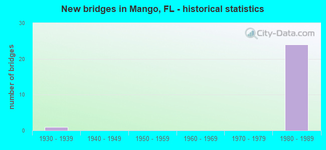
- New bridges - historical statistics
- 11930-1939
- 241980-1989

- Reconstructed bridges - Historical Statistics
- 11930-1939
- 01940-1949
- 01950-1959
- 01960-1969
- 01970-1979
- 01980-1989
- 11990-1999


- Bridge Condition - Deck
- 91.7%Good
- 8.3%Satisfactory

- Bridge Condition - Superstructure
- 25.0%Very good
- 66.7%Good
- 8.3%Fair

- Bridge Condition - Substructure
- 33.3%Very good
- 66.7%Good
Find on map >> Show street view
Structure Number: 100024, Location: 0.9 MI EAST OF I-75 (Lat: 27.999939, Lng: -82.312225), Route carried "on" structure: US 92, Year Built: 1930, Year Reconstructed: 1943, Status: Open, Structure Length: 1.34m (4.40ft), Average Daily Traffic: 12,400 (year 2021), Truck Traffic: 13%, Average Future Daily Traffic: 21,514 (year 2041), Design Load: H 15, Features Intersected: KENNEDY HILL CREEK
Minimum Vertical Clearance: 30+ m (98+ ft), Kilometerpoint: 13.723, Lanes on structure: 2, Base Highway Network: Yes, Owner: State Highway Agency, Approaching Roadway Width: 9.9m (32.5ft), Material/Design: Concrete, Design/Construction: Slab, Number Of Spans In Main Unit: 2, Length of Maximum Span: 6.7m (22.0ft), Curb-To-Curb Width: 9.9m (32.5ft), Out-to-Out Width: 10.2m (33.5ft)
Condition: Deck: Good, Superstructure: Good, Substructure: Good, Channel: Satisfactory, Operating Rating: 33.7 metric tons, Method Used To Determine Operating Rating: Load and Resistance Factor (LRFR), Inventory Rating: 26.0 metric tons, Method Used To Determine Inventory Rating: Load and Resistance Factor (LRFR), Structural Evaluation: Equal to present minimum criteria, Deck Geometry: Meets minimum limits, Waterway Adequacy: Equal to present desirable criteria, Approach Roadway Alignment: Equal to present desirable criteria, Designated Inspection Frequency: Every 24 months, Inspection Date: June 2021, Deck Structure Type: Concrete Cast-file-Place, Wearing Surface/Protective System: Wearing Surface: Bituminous
Find on map >> Show street view
Structure Number: 100394, Location: I-75 & I-4 INTERCHANGE (Lat: 28.002100, Lng: -82.326925), Route carried "on" structure: Interstate 75, Year Built: 1984, Status: Open, Structure Length: 14.50m (47.57ft), Average Daily Traffic: 74,500 (year 2021), Truck Traffic: 12%, Average Future Daily Traffic: 129,258 (year 2041), Design Load: HS 20+Mod, Features Intersected: I-4 AND RAMP C-1
Minimum Vertical Clearance: 30+ m (98+ ft), Kilometerpoint: 43.530, Lanes on structure: 3, Lanes under structure: 7, Base Highway Network: Yes, Owner: State Highway Agency, Approaching Roadway Width: 17.2m (56.4ft), Material/Design: Prestressed concrete, Design/Construction: Stringer/Multi-beam, Number Of Spans In Main Unit: 6, Length of Maximum Span: 30.8m (101.0ft), Curb-To-Curb Width: 17.2m (56.4ft), Out-to-Out Width: 18.3m (60.0ft)
Condition: Deck: Good, Superstructure: Very good, Substructure: Good, Operating Rating: 49.0 metric tons, Method Used To Determine Operating Rating: Allowable Stress (AS), Inventory Rating: 43.5 metric tons, Method Used To Determine Inventory Rating: Allowable Stress (AS), Structural Evaluation: Better than present minimum criteria, Deck Geometry: Better than present minimum criteria, Underclear: Meets minimum limits, Approach Roadway Alignment: Equal to present desirable criteria, Designated Inspection Frequency: Every 24 months, Inspection Date: December 2021, Deck Structure Type: Concrete Cast-file-Place
Find on map >> Show street view
Structure Number: 100414, Location: 0.4MI SOUTH OF I-4(SR400) (Lat: 27.997108, Lng: -82.326775), Route carried "on" structure: Interstate 75, Year Built: 1983, Status: Open, Structure Length: 5.77m (18.93ft), Average Daily Traffic: 74,500 (year 2021), Truck Traffic: 12%, Average Future Daily Traffic: 129,258 (year 2041), Features Intersected: US-92 (SR-600)
Minimum Vertical Clearance: 30+ m (98+ ft), Kilometerpoint: 43.039, Lanes on structure: 3, Lanes under structure: 2, Base Highway Network: Yes, Owner: State Highway Agency, Approaching Roadway Width: 17.0m (55.8ft), Material/Design: Prestressed concrete, Design/Construction: Stringer/Multi-beam, Number Of Spans In Main Unit: 3, Length of Maximum Span: 32.3m (106.0ft), Curb-To-Curb Width: 17.1m (56.1ft), Out-to-Out Width: 18.9m (62.0ft)
Condition: Deck: Good, Superstructure: Very good, Substructure: Very good, Operating Rating: 61.7 metric tons, Method Used To Determine Operating Rating: Allowable Stress (AS), Inventory Rating: 49.0 metric tons, Method Used To Determine Inventory Rating: Allowable Stress (AS), Structural Evaluation: Equal to present desirable criteria, Deck Geometry: Equal to present minimum criteria, Underclear: Equal to present minimum criteria, Approach Roadway Alignment: Equal to present desirable criteria, Length Of Structure Improvement: 0.58m (1.90ft), Designated Inspection Frequency: Every 24 months, Inspection Date: December 2021, Bridge Improvement Cost: $8,000, Roadway Improvement Cost: $1,000, Total Project Cost: $9,000, Deck Structure Type: Concrete Cast-file-Place
Find on map >> Show street view
Structure Number: 100415, Location: 0.4MI SOUTH OF I-4(SR400) (Lat: 27.997183, Lng: -82.326381), Route carried "on" structure: Interstate 75, Year Built: 1983, Status: Open, Structure Length: 5.77m (18.93ft), Average Daily Traffic: 74,500 (year 2021), Truck Traffic: 12%, Average Future Daily Traffic: 129,258 (year 2041), Design Load: HS 20+Mod, Features Intersected: US-92 (SR-600)
Minimum Vertical Clearance: 30+ m (98+ ft), Kilometerpoint: 43.042, Lanes on structure: 3, Lanes under structure: 2, Base Highway Network: Yes, Owner: State Highway Agency, Approaching Roadway Width: 19.5m (64.0ft), Material/Design: Prestressed concrete, Design/Construction: Stringer/Multi-beam, Number Of Spans In Main Unit: 3, Length of Maximum Span: 32.3m (106.0ft), Curb-To-Curb Width: 19.5m (64.0ft), Out-to-Out Width: 20.6m (67.6ft)
Condition: Deck: Good, Superstructure: Very good, Substructure: Very good, Operating Rating: 49.9 metric tons, Method Used To Determine Operating Rating: Allowable Stress (AS), Inventory Rating: 40.8 metric tons, Method Used To Determine Inventory Rating: Allowable Stress (AS), Structural Evaluation: Equal to present desirable criteria, Deck Geometry: Superior to present desirable criteria, Underclear: Equal to present minimum criteria, Approach Roadway Alignment: Equal to present desirable criteria, Designated Inspection Frequency: Every 24 months, Inspection Date: December 2021, Deck Structure Type: Concrete Cast-file-Place
Find on map >> Show street view
Structure Number: 100417, Location: I-4 & I-75 INTERCHANGE (Lat: 27.999850, Lng: -82.326692), Route carried "on" structure: Interstate 75, Year Built: 1983, Year Reconstructed: 2004, Status: Open, Structure Length: 5.09m (16.70ft), Average Daily Traffic: 74,500 (year 2021), Truck Traffic: 12%, Average Future Daily Traffic: 129,258 (year 2041), Design Load: HS 20+Mod, Features Intersected: I-4 EB TO I-75 NB
Minimum Vertical Clearance: 30+ m (98+ ft), Kilometerpoint: 43.356, Lanes on structure: 3, Lanes under structure: 1, Base Highway Network: Yes, Owner: State Highway Agency, Approaching Roadway Width: 17.0m (55.8ft), Skew: 2 degrees, Material/Design: Prestressed concrete, Design/Construction: Stringer/Multi-beam, Number Of Spans In Main Unit: 3, Length of Maximum Span: 28.6m (93.8ft), Curb-To-Curb Width: 17.0m (55.8ft), Out-to-Out Width: 18.0m (59.1ft)
Condition: Deck: Good, Superstructure: Good, Substructure: Good, Operating Rating: 58.1 metric tons, Method Used To Determine Operating Rating: Allowable Stress (AS), Inventory Rating: 51.7 metric tons, Method Used To Determine Inventory Rating: Allowable Stress (AS), Structural Evaluation: Better than present minimum criteria, Deck Geometry: Equal to present minimum criteria, Underclear: Superior to present desirable criteria, Approach Roadway Alignment: Equal to present desirable criteria, Designated Inspection Frequency: Every 24 months, Inspection Date: December 2021, Deck Structure Type: Concrete Cast-file-Place
Find on map >> Show street view
Structure Number: 100422, Location: 0.4MI SOUTH OF I-4 (Lat: 27.997281, Lng: -82.325892), Route carried "on" structure: Ramp Interstate 75, Year Built: 1983, Status: Open, Structure Length: 6.25m (20.51ft), Average Daily Traffic: 18,500 (year 2021), Truck Traffic: 9%, Average Future Daily Traffic: 32,098 (year 2041), Design Load: HS 20+Mod, Features Intersected: US-92 (SR-600)
Minimum Vertical Clearance: 30+ m (98+ ft), Kilometerpoint: 0.066, Lanes on structure: 2, Lanes under structure: 2, Owner: State Highway Agency, Approaching Roadway Width: 12.2m (40.0ft), Skew: 2 degrees, Material/Design: Prestressed concrete, Design/Construction: Stringer/Multi-beam, Number Of Spans In Main Unit: 3, Length of Maximum Span: 35.0m (114.8ft), Curb-To-Curb Width: 12.2m (40.0ft), Out-to-Out Width: 13.1m (43.0ft)
Condition: Deck: Good, Superstructure: Good, Substructure: Good, Operating Rating: 59.0 metric tons, Method Used To Determine Operating Rating: Allowable Stress (AS), Inventory Rating: 51.7 metric tons, Method Used To Determine Inventory Rating: Allowable Stress (AS), Structural Evaluation: Better than present minimum criteria, Deck Geometry: Superior to present desirable criteria, Underclear: Equal to present minimum criteria, Approach Roadway Alignment: Equal to present desirable criteria, Designated Inspection Frequency: Every 24 months, Inspection Date: December 2021, Deck Structure Type: Concrete Cast-file-Place
Find on map >> Show street view
Structure Number: 100423, Location: I-4 & I-75 INTERCHANGE (Lat: 28.002303, Lng: -82.324831), Route carried "on" structure: Ramp Interstate 75, Year Built: 1984, Status: Open, Structure Length: 8.78m (28.81ft), Average Daily Traffic: 17,500 (year 2021), Truck Traffic: 9%, Average Future Daily Traffic: 30,362 (year 2041), Design Load: HS 20+Mod, Features Intersected: I-4 & RAMP I75SB TO I4EB
Minimum Vertical Clearance: 30+ m (98+ ft), Kilometerpoint: 0.290, Lanes on structure: 1, Lanes under structure: 7, Owner: State Highway Agency, Approaching Roadway Width: 8.2m (26.9ft), Skew: 9 degrees, Material/Design: Prestressed concrete, Design/Construction: Stringer/Multi-beam, Number Of Spans In Main Unit: 3, Length of Maximum Span: 38.4m (126.0ft), Curb-To-Curb Width: 8.2m (26.9ft), Out-to-Out Width: 9.2m (30.2ft)
Condition: Deck: Good, Superstructure: Good, Substructure: Good, Operating Rating: 52.0 metric tons, Method Used To Determine Operating Rating: Load Factor (LF), Inventory Rating: 31.2 metric tons, Method Used To Determine Inventory Rating: Load Factor (LF), Structural Evaluation: Better than present minimum criteria, Deck Geometry: Superior to present desirable criteria, Underclear: Equal to present minimum criteria, Approach Roadway Alignment: Equal to present desirable criteria, Designated Inspection Frequency: Every 24 months, Inspection Date: December 2021, Deck Structure Type: Concrete Cast-file-Place
Find on map >> Show street view
Structure Number: 100427, Location: 2.3MI EAST OF US-301 (Lat: 27.981297, Lng: -82.326367), Route carried "on" structure: State highway 574, Year Built: 1984, Status: Open, Structure Length: 8.69m (28.51ft), Average Daily Traffic: 38,500 (year 2022), Truck Traffic: 6%, Average Future Daily Traffic: 66,798 (year 2042), Design Load: HL 93, Features Intersected: I-75 (SR-93)
Minimum Vertical Clearance: 30+ m (98+ ft), Kilometerpoint: 17.555, Lanes on structure: 5, Lanes under structure: 7, Base Highway Network: Yes, Owner: State Highway Agency, Approaching Roadway Width: 23.4m (76.8ft), Skew: 20 degrees, Material/Design: Prestressed concrete continuous, Design/Construction: Stringer/Multi-beam, Number Of Spans In Main Unit: 2, Length of Maximum Span: 44.0m (144.4ft), Curb or Sidewalk Widths: Left: 0.0m, Right: 1.5m (4.9ft), Curb-To-Curb Width: 28.1m (92.2ft), Out-to-Out Width: 31.1m (102.0ft)
Condition: Deck: Good, Superstructure: Fair, Substructure: Very good, Operating Rating: 47.0 metric tons, Method Used To Determine Operating Rating: Load and Resistance Factor (LRFR), Inventory Rating: 39.6 metric tons, Method Used To Determine Inventory Rating: Load and Resistance Factor (LRFR), Structural Evaluation: Somewhat better than minimum adequacy, Deck Geometry: Superior to present desirable criteria, Underclear: Somewhat better than minimum adequacy, Approach Roadway Alignment: Equal to present desirable criteria, Designated Inspection Frequency: Every 24 months, Inspection Date: October 2021, Deck Structure Type: Concrete Cast-file-Place
Find on map >> Show street view
Structure Number: 100428, Location: I-4 & I-75 INTERCHANGE (Lat: 28.002219, Lng: -82.325894), Route carried "on" structure: Ramp Interstate 75, Year Built: 1984, Status: Open, Structure Length: 9.68m (31.76ft), Average Daily Traffic: 11,500 (year 2021), Truck Traffic: 9%, Average Future Daily Traffic: 19,952 (year 2041), Design Load: HL 93, Features Intersected: I-4
Minimum Vertical Clearance: 30+ m (98+ ft), Kilometerpoint: 0.529, Lanes on structure: 1, Lanes under structure: 7, Owner: State Highway Agency, Approaching Roadway Width: 8.3m (27.2ft), Skew: 9 degrees, Material/Design: Steel continuous, Design/Construction: Stringer/Multi-beam, Number Of Spans In Main Unit: 3, Length of Maximum Span: 47.2m (154.9ft), Curb-To-Curb Width: 8.3m (27.2ft), Out-to-Out Width: 9.5m (31.2ft)
Condition: Deck: Good, Superstructure: Good, Substructure: Very good, Operating Rating: 45.4 metric tons, Method Used To Determine Operating Rating: Load and Resistance Factor (LRFR), Inventory Rating: 35.2 metric tons, Method Used To Determine Inventory Rating: Load and Resistance Factor (LRFR), Structural Evaluation: Better than present minimum criteria, Deck Geometry: Superior to present desirable criteria, Underclear: Somewhat better than minimum adequacy, Approach Roadway Alignment: Better than present minimum criteria, Designated Inspection Frequency: Every 24 months, Inspection Date: December 2021, Deck Structure Type: Concrete Cast-file-Place
Find on map >> Show street view
Structure Number: 100429, Location: 0.4MI NORTH OF US-92 (Lat: 28.003194, Lng: -82.319056), Route carried "on" structure: County highway , Year Built: 1984, Status: Open, Structure Length: 7.91m (25.95ft), Average Daily Traffic: 2,600 (year 2021), Truck Traffic: 8%, Average Future Daily Traffic: 4,511 (year 2041), Design Load: HS 20, Features Intersected: RAMP A-1 & I-4, Facility Carried by Structure: WILLIAMS ROAD
Minimum Vertical Clearance: 30+ m (98+ ft), Kilometerpoint: 3.224, Lanes on structure: 2, Lanes under structure: 8, Owner: State Highway Agency, Approaching Roadway Width: 9.3m (30.5ft), Material/Design: Prestressed concrete, Design/Construction: Stringer/Multi-beam, Number Of Spans In Main Unit: 4, Length of Maximum Span: 33.0m (108.3ft), Curb-To-Curb Width: 12.2m (40.0ft), Out-to-Out Width: 13.1m (43.0ft)
Condition: Deck: Good, Superstructure: Good, Substructure: Good, Inventory Rating: 67.5 metric tons, Method Used To Determine Inventory Rating: Load Factor (LF), Structural Evaluation: Better than present minimum criteria, Deck Geometry: Equal to present minimum criteria, Underclear: High priority of corrective action, Approach Roadway Alignment: Better than present minimum criteria, Designated Inspection Frequency: Every 24 months, Inspection Date: March 2021, Deck Structure Type: Concrete Cast-file-Place
Find on map >> Show street view
Structure Number: 100435, Location: 3.1MI N OF SR-60 (Lat: 27.973169, Lng: -82.326528), Route carried "on" structure: Interstate 75, Year Built: 1983, Status: Open, Structure Length: 10.98m (36.02ft), Average Daily Traffic: 70,750 (year 2021), Truck Traffic: 7%, Average Future Daily Traffic: 122,751 (year 2041), Design Load: HS 20, Features Intersected: CR-574 AND CSX RR
Minimum Vertical Clearance: 30+ m (98+ ft), Kilometerpoint: 40.356, Lanes on structure: 3, Lanes under structure: 2, Owner: State Highway Agency, Approaching Roadway Width: 17.1m (56.1ft), Material/Design: Prestressed concrete, Design/Construction: Stringer/Multi-beam, Number Of Spans In Main Unit: 5, Length of Maximum Span: 27.8m (91.2ft), Curb-To-Curb Width: 17.1m (56.1ft), Out-to-Out Width: 18.0m (59.1ft)
Condition: Deck: Satisfactory, Superstructure: Good, Substructure: Good, Operating Rating: 76.7 metric tons, Method Used To Determine Operating Rating: Load Factor (LF), Inventory Rating: 46.0 metric tons, Method Used To Determine Inventory Rating: Load Factor (LF), Structural Evaluation: Better than present minimum criteria, Deck Geometry: Equal to present minimum criteria, Underclear: Better than present minimum criteria, Approach Roadway Alignment: Equal to present desirable criteria, Designated Inspection Frequency: Every 24 months, Inspection Date: October 2021, Deck Structure Type: Concrete Precast Panels
Find on map >> Show street view
Structure Number: 100436, Location: 3.1MI N OF SR-60 (Lat: 27.973164, Lng: -82.326181), Route carried "on" structure: Interstate 75, Year Built: 1983, Status: Open, Structure Length: 10.98m (36.02ft), Average Daily Traffic: 70,750 (year 2021), Truck Traffic: 7%, Average Future Daily Traffic: 122,751 (year 2041), Features Intersected: CR-574 & CSX RR
Minimum Vertical Clearance: 30+ m (98+ ft), Kilometerpoint: 40.361, Lanes on structure: 3, Lanes under structure: 2, Base Highway Network: Yes, Owner: State Highway Agency, Approaching Roadway Width: 17.1m (56.1ft), Material/Design: Prestressed concrete, Design/Construction: Stringer/Multi-beam, Number Of Spans In Main Unit: 5, Length of Maximum Span: 27.8m (91.2ft), Curb-To-Curb Width: 17.1m (56.1ft), Out-to-Out Width: 18.0m (59.1ft)
Condition: Deck: Good, Superstructure: Good, Substructure: Good, Operating Rating: 76.7 metric tons, Method Used To Determine Operating Rating: Load Factor (LF), Inventory Rating: 46.0 metric tons, Method Used To Determine Inventory Rating: Load Factor (LF), Structural Evaluation: Better than present minimum criteria, Deck Geometry: Equal to present minimum criteria, Underclear: Better than present minimum criteria, Approach Roadway Alignment: Equal to present desirable criteria, Designated Inspection Frequency: Every 24 months, Inspection Date: October 2021, Deck Structure Type: Concrete Precast Panels
Find on map >> Show street view
Structure Number: 100437, Location: 0.1MI SOUTH OF CR-574 (Lat: 27.973986, Lng: -82.326333), Route carried "on" structure: Interstate 75, Year Built: 1983, Status: Open, Structure Length: 0.77m (2.53ft), Average Daily Traffic: 141,500 (year 2021), Truck Traffic: 7%, Average Future Daily Traffic: 245,502 (year 2041), Design Load: HS 20+Mod, Features Intersected: MANGO LAKE DRAIN CANAL
Minimum Vertical Clearance: 30+ m (98+ ft), Kilometerpoint: 40.520, Lanes on structure: 6, Base Highway Network: Yes, Owner: State Highway Agency, Approaching Roadway Width: 32.9m (107.9ft), Skew: 11 degrees, Material/Design: Concrete, Design/Construction: Culvert, Number Of Spans In Main Unit: 2, Length of Maximum Span: 3.6m (11.8ft)
Condition: Channel: Satisfactory, Culverts: Good, Structural Evaluation: Better than present minimum criteria, Waterway Adequacy: Equal to present desirable criteria, Approach Roadway Alignment: Equal to present desirable criteria, Designated Inspection Frequency: Every 24 months, Inspection Date: October 2021
Find on map >> Show street view
Structure Number: 100394, Location: I-75 & I-4 INTERCHANGE (Lat: 28.002100, Lng: -82.326925), Route carried "under" structure: Ramp Interstate 4, Year Built: 1984, Structure Length: 0. m, Average Daily Traffic: 13,500 (year 2021), Truck Traffic: 9%, Features Intersected: I-4 AND RAMP C-1, Facility Carried by Structure: I-75 NB
Minimum Vertical Clearance: 6.89m (22.60ft), Kilometerpoint: 0.000, Lanes on structure: 3, Lanes under structure: 1, Material/Design: Prestressed concrete, Design/Construction: Stringer/Multi-beam, Length of Maximum Span: 30.8m (101.0ft)
Find on map >> Show street view
Structure Number: 100394, Location: I-75 & I-4 INTERCHANGE (Lat: 28.002100, Lng: -82.326925), Route carried "under" structure: Interstate 4, Year Built: 1984, Structure Length: 0. m, Average Daily Traffic: 130,000 (year 2021), Truck Traffic: 16%, Features Intersected: I-4 AND RAMP C-1, Facility Carried by Structure: I-75 NB
Minimum Vertical Clearance: 7.25m (23.79ft), Kilometerpoint: 25.585, Lanes on structure: 3, Lanes under structure: 6, Material/Design: Prestressed concrete, Design/Construction: Stringer/Multi-beam, Length of Maximum Span: 30.8m (101.0ft)
Find on map >> Show street view
Structure Number: 100414, Location: 0.4MI SOUTH OF I-4(SR400) (Lat: 27.997108, Lng: -82.326775), Route carried "under" structure: US 92, Year Built: 1983, Structure Length: 0. m, Average Daily Traffic: 12,400 (year 2021), Truck Traffic: 13%, Features Intersected: US-92 (SR-600), Facility Carried by Structure: I-75 SB (SR-93A)
Minimum Vertical Clearance: 5.58m (18.31ft), Kilometerpoint: 12.252, Lanes on structure: 3, Lanes under structure: 2, Material/Design: Prestressed concrete, Design/Construction: Stringer/Multi-beam, Length of Maximum Span: 32.3m (106.0ft)
Find on map >> Show street view
Structure Number: 100415, Location: 0.4MI SOUTH OF I-4(SR400) (Lat: 27.997183, Lng: -82.326381), Route carried "under" structure: US 92, Year Built: 1983, Structure Length: 0. m, Average Daily Traffic: 12,400 (year 2021), Truck Traffic: 13%, Features Intersected: US-92 (SR-600), Facility Carried by Structure: I-75 NB (SR-93A)
Minimum Vertical Clearance: 6.04m (19.82ft), Kilometerpoint: 12.294, Lanes on structure: 3, Lanes under structure: 2, Material/Design: Prestressed concrete, Design/Construction: Stringer/Multi-beam, Length of Maximum Span: 32.3m (106.0ft)
Find on map >> Show street view
Structure Number: 100417, Location: I-4 & I-75 INTERCHANGE (Lat: 27.999850, Lng: -82.326692), Route carried "under" structure: Ramp Interstate 4, Year Built: 1983, Structure Length: 0. m, Average Daily Traffic: 11,500 (year 2021), Truck Traffic: 9%, Features Intersected: I-4 EB TO I-75 NB, Facility Carried by Structure: I-75 NB (SR-93A)
Minimum Vertical Clearance: 5.33m (17.49ft), Kilometerpoint: 0.000, Lanes on structure: 3, Lanes under structure: 1, Material/Design: Prestressed concrete, Design/Construction: Stringer/Multi-beam, Length of Maximum Span: 28.6m (93.8ft)
Find on map >> Show street view
Structure Number: 100422, Location: 0.4MI SOUTH OF I-4 (Lat: 27.997281, Lng: -82.325892), Route carried "under" structure: US 92, Year Built: 1983, Structure Length: 0. m, Average Daily Traffic: 12,400 (year 2021), Truck Traffic: 13%, Features Intersected: US-92 (SR-600), Facility Carried by Structure: I-75 NB TO I-4 EB
Minimum Vertical Clearance: 5.12m (16.80ft), Kilometerpoint: 12.348, Lanes on structure: 2, Lanes under structure: 2, Material/Design: Prestressed concrete, Design/Construction: Stringer/Multi-beam, Length of Maximum Span: 35.0m (114.8ft)
Find on map >> Show street view
Structure Number: 100423, Location: I-4 & I-75 INTERCHANGE (Lat: 28.002303, Lng: -82.324831), Route carried "under" structure: Interstate 4, Year Built: 1984, Structure Length: 0. m, Average Daily Traffic: 130,000 (year 2021), Truck Traffic: 16%, Features Intersected: I-4 & RAMP I75SB TO I4EB
Minimum Vertical Clearance: 5.12m (16.80ft), Kilometerpoint: 25.825, Lanes on structure: 1, Lanes under structure: 7, Material/Design: Prestressed concrete, Design/Construction: Stringer/Multi-beam, Length of Maximum Span: 38.4m (126.0ft)
Find on map >> Show street view
Structure Number: 100427, Location: 2.3MI EAST OF US-301 (Lat: 27.981297, Lng: -82.326367), Route carried "under" structure: Interstate 75, Year Built: 1984, Structure Length: 0. m, Average Daily Traffic: 141,500 (year 2022), Truck Traffic: 7%, Features Intersected: I-75 (SR-93), Facility Carried by Structure: SR-574 (MLK BLVD)
Minimum Vertical Clearance: 4.85m (15.91ft), Kilometerpoint: 41.228, Lanes on structure: 5, Lanes under structure: 7, Material/Design: Prestressed concrete continuous, Design/Construction: Stringer/Multi-beam, Length of Maximum Span: 44.0m (144.4ft)
Find on map >> Show street view
Structure Number: 100428, Location: I-4 & I-75 INTERCHANGE (Lat: 28.002219, Lng: -82.325894), Route carried "under" structure: Interstate 4, Year Built: 1984, Structure Length: 0. m, Average Daily Traffic: 130,000 (year 2021), Truck Traffic: 16%, Features Intersected: I-4
Minimum Vertical Clearance: 5.24m (17.19ft), Kilometerpoint: 25.724, Lanes on structure: 1, Lanes under structure: 7, Material/Design: Steel continuous, Design/Construction: Stringer/Multi-beam, Length of Maximum Span: 47.2m (154.9ft)
Find on map >> Show street view
Structure Number: 100429, Location: 0.4MI NORTH OF US-92 (Lat: 28.003194, Lng: -82.319056), Route carried "under" structure: Interstate 4, Year Built: 1984, Structure Length: 0. m, Average Daily Traffic: 154,500 (year 2021), Truck Traffic: 10%, Features Intersected: RAMP A-1 & I-4, Facility Carried by Structure: WILLIAMS ROAD
Minimum Vertical Clearance: 5.27m (17.29ft), Kilometerpoint: 26.366, Lanes on structure: 2, Lanes under structure: 8, Material/Design: Prestressed concrete, Design/Construction: Stringer/Multi-beam, Length of Maximum Span: 33.0m (108.3ft)
Find on map >> Show street view
Structure Number: 100435, Location: 3.1MI N OF SR-60 (Lat: 27.973169, Lng: -82.326528), Route carried "under" structure: County highway 574, Year Built: 1983, Structure Length: 0. m, Average Daily Traffic: 21,500 (year 2021), Truck Traffic: 30%, Features Intersected: CR-574 AND CSX RR, Facility Carried by Structure: I-75 SB
Minimum Vertical Clearance: 8.11m (26.61ft), Kilometerpoint: 0.000, Lanes on structure: 3, Lanes under structure: 2, Material/Design: Prestressed concrete, Design/Construction: Stringer/Multi-beam, Length of Maximum Span: 27.8m (91.2ft)
Find on map >> Show street view
Structure Number: 100436, Location: 3.1MI N OF SR-60 (Lat: 27.973164, Lng: -82.326181), Route carried "under" structure: County highway 574, Year Built: 1983, Structure Length: 0. m, Average Daily Traffic: 21,500 (year 2021), Truck Traffic: 30%, Features Intersected: CR-574 & CSX RR, Facility Carried by Structure: I-75 NB
Minimum Vertical Clearance: 8.23m (27.00ft), Kilometerpoint: 0.000, Lanes on structure: 3, Lanes under structure: 2, Material/Design: Prestressed concrete, Design/Construction: Stringer/Multi-beam, Length of Maximum Span: 27.8m (91.2ft)