Bridge Statistics for Magna, Utah (UT)
Condition, Traffic, Stress, Structural Evaluation, Project Costs
- National Bridge Inventory (NBI) Statistics
- 12Number of bridges
- 49ft / 14.6mTotal length
- 200,852Total average daily traffic
- 47,806Total average daily truck traffic
- National Bridge Inventory (NBI) Registered Bridges for Magna
- No street view available for this location
- New bridges - historical statistics
- 21960-1969
- 11970-1979
- 21980-1989
- 42000-2009
- 22010-2019
- 12020-2022
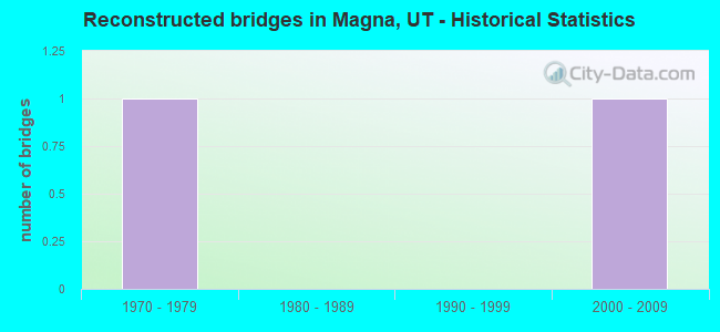
- Reconstructed bridges - Historical Statistics
- 11970-1979
- 01980-1989
- 01990-1999
- 12000-2009
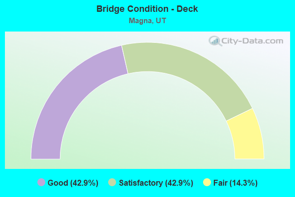
- Bridge Condition - Deck
- 42.9%Good
- 42.9%Satisfactory
- 14.3%Fair
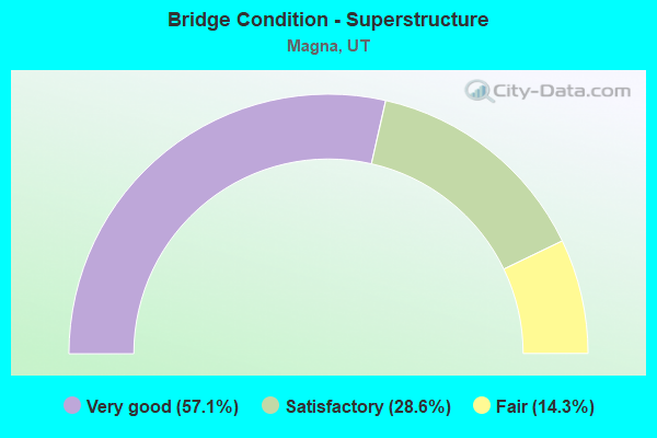
- Bridge Condition - Superstructure
- 57.1%Very good
- 28.6%Satisfactory
- 14.3%Fair
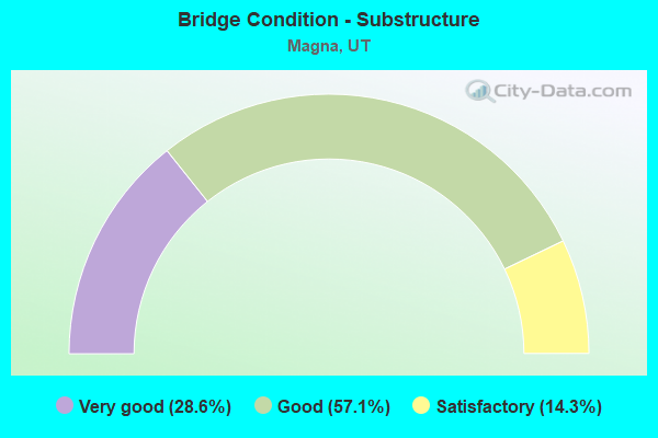
- Bridge Condition - Substructure
- 28.6%Very good
- 57.1%Good
- 14.3%Satisfactory
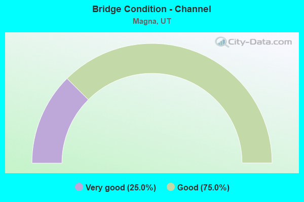
- Bridge Condition - Channel
- 25.0%Very good
- 75.0%Good
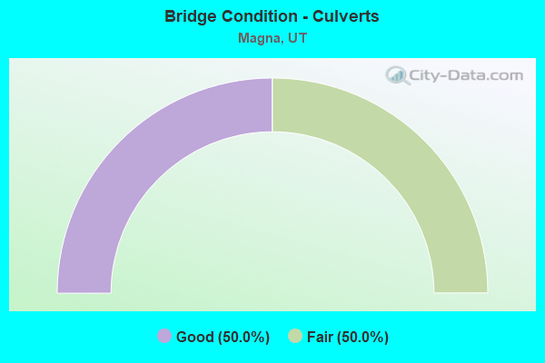
- Bridge Condition - Culverts
- 50.0%Good
- 50.0%Fair
Find on map >> Show street view
Structure Number: 35032D, Location: 3700 S. 8000 W., SL.CO. (Lat: 40.691894, Lng: -112.082275), Route carried "on" structure: County highway 2151, Year Built: 1975, Status: Open, Structure Length: 0.81m (2.66ft), Average Daily Traffic: 2,961 (year 2020), Average Future Daily Traffic: 3,701 (year 2040), Design Load: HS 20+Mod, Features Intersected: UTAH AND SL CANAL, Facility Carried by Structure: 8000 WEST STREET
Minimum Vertical Clearance: 30+ m (98+ ft), Kilometerpoint: 1.098, Lanes on structure: 2, Owner: Town or Township Highway Agency, Maintenance Responsibility: County Highway Agency, Approaching Roadway Width: 13.7m (44.9ft), Material/Design: Concrete, Design/Construction: Slab, Number Of Spans In Main Unit: 1, Length of Maximum Span: 7.0m (23.0ft), Curb or Sidewalk Widths: Left: 3.0m (9.8ft), Right: 6.8m (22.3ft), Curb-To-Curb Width: 13.7m (44.9ft), Out-to-Out Width: 24.4m (80.1ft)
Condition: Deck: Fair, Superstructure: Fair, Substructure: Satisfactory, Channel: Good, Operating Rating: 46.7 metric tons, Method Used To Determine Operating Rating: Load and Resistance Factor Rating (LRFR) rating reported by rating factor(RF) method using HL-93 loadings, Inventory Rating: 27.2 metric tons, Method Used To Determine Inventory Rating: Load and Resistance Factor Rating (LRFR) rating reported by rating factor(RF) method using HL-93 loadings, Structural Evaluation: Somewhat better than minimum adequacy, Deck Geometry: Superior to present desirable criteria, Waterway Adequacy: Better than present minimum criteria, Approach Roadway Alignment: Equal to present desirable criteria, Designated Inspection Frequency: Every 24 months, Inspection Date: December 2021, Deck Structure Type: Concrete Cast-file-Place, Wearing Surface/Protective System: Wearing Surface: Bituminous
Find on map >> Show street view
Structure Number: 35141D, Location: 3800 S. 7600 W., SL.CO. (Lat: 40.688847, Lng: -112.072386), Route carried "on" structure: County highway , Year Built: 1986, Status: Open, Structure Length: 0.69m (2.26ft), Average Daily Traffic: 630 (year 2020), Truck Traffic: 1%, Average Future Daily Traffic: 765 (year 2040), Design Load: H 15, Features Intersected: UTAH AND SALT LAKE CAN, Facility Carried by Structure: VALLEY FORGE R0AD
Minimum Vertical Clearance: 30+ m (98+ ft), Kilometerpoint: 0.056, Lanes on structure: 2, Owner: Town or Township Highway Agency, Maintenance Responsibility: County Highway Agency, Approaching Roadway Width: 12.5m (41.0ft), Material/Design: Concrete, Design/Construction: Frame, Number Of Spans In Main Unit: 1, Length of Maximum Span: 6.2m (20.3ft), Curb or Sidewalk Widths: Left: 1.2m (3.9ft), Right: 1.2m (3.9ft), Curb-To-Curb Width: 12.5m (41.0ft), Out-to-Out Width: 18.3m (60.0ft)
Condition: Deck: Satisfactory, Superstructure: Satisfactory, Substructure: Good, Channel: Good, Operating Rating: 61.9 metric tons, Method Used To Determine Operating Rating: Load and Resistance Factor Rating (LRFR) rating reported by rating factor(RF) method using HL-93 loadings, Inventory Rating: 32.4 metric tons, Method Used To Determine Inventory Rating: Load Factor (LF) rating reported by rating factor (RF) method using MS18 loading, Structural Evaluation: Equal to present minimum criteria, Deck Geometry: Superior to present desirable criteria, Waterway Adequacy: Better than present minimum criteria, Approach Roadway Alignment: Equal to present desirable criteria, Designated Inspection Frequency: Every 24 months, Inspection Date: December 2021, Deck Structure Type: Concrete Precast Panels, Wearing Surface/Protective System: Wearing Surface: Bituminous
Find on map >> Show street view
Structure Number: 35142E, Location: 2500 S. 8000 W., SL.CO. (Lat: 40.715761, Lng: -112.082292), Route carried "on" structure: County highway 2151, Year Built: 1987, Status: Open, Structure Length: 0.69m (2.26ft), Average Daily Traffic: 993 (year 2020), Average Future Daily Traffic: 1,241 (year 2040), Design Load: HS 20+Mod, Features Intersected: RITER CANAL, Facility Carried by Structure: 8000 WEST STREET
Minimum Vertical Clearance: 30+ m (98+ ft), Kilometerpoint: 3.747, Lanes on structure: 2, Owner: Town or Township Highway Agency, Maintenance Responsibility: County Highway Agency, Approaching Roadway Width: 13.7m (44.9ft), Skew: 2 degrees, Material/Design: Concrete, Design/Construction: Culvert, Number Of Spans In Main Unit: 1, Length of Maximum Span: 6.4m (21.0ft), Curb or Sidewalk Widths: Left: 3.0m (9.8ft), Right: 3.0m (9.8ft), Curb-To-Curb Width: 13.7m (44.9ft), Out-to-Out Width: 13.7m (44.9ft)
Condition: Channel: Good, Culverts: Fair, Operating Rating: 32.4 metric tons, Method Used To Determine Operating Rating: Load and Resistance Factor Rating (LRFR) rating reported by rating factor(RF) method using HL-93 loadings, Inventory Rating: 19.4 metric tons, Method Used To Determine Inventory Rating: Load Factor (LF) rating reported by rating factor (RF) method using MS18 loading, Structural Evaluation: Somewhat better than minimum adequacy, Deck Geometry: Superior to present desirable criteria, Waterway Adequacy: Better than present minimum criteria, Approach Roadway Alignment: Equal to present desirable criteria, Designated Inspection Frequency: Every 24 months, Inspection Date: December 2021, Deck Structure Type: Concrete Cast-file-Place, Wearing Surface/Protective System: Wearing Surface: Bituminous
Find on map >> Show street view
Structure Number: 35237E, Location: 7200 West 3900 South (Lat: 40.687050, Lng: -112.063072), Route carried "on" structure: City street 2238, Year Built: 2017, Status: Open, Structure Length: 0.67m (2.20ft), Average Daily Traffic: 10,838 (year 2020), Average Future Daily Traffic: 13,548 (year 2040), Features Intersected: Utah and Salt Lake Canal, Facility Carried by Structure: 7200 West
Minimum Vertical Clearance: 30+ m (98+ ft), Kilometerpoint: 0.561, Lanes on structure: 5, Owner: City or Municipal Highway Agency, Approaching Roadway Width: 26.5m (86.9ft), Material/Design: Concrete, Design/Construction: Culvert, Number Of Spans In Main Unit: 1, Length of Maximum Span: 6.1m (20.0ft), Curb or Sidewalk Widths: Left: 4.9m (16.1ft), Right: 4.9m (16.1ft), Curb-To-Curb Width: 26.5m (86.9ft), Out-to-Out Width: 27.4m (89.9ft)
Condition: Channel: Very good, Culverts: Good, Operating Rating: 51.5 metric tons, Method Used To Determine Operating Rating: Load and Resistance Factor Rating (LRFR) rating reported by rating factor(RF) method using HL-93 loadings, Inventory Rating: 41.1 metric tons, Method Used To Determine Inventory Rating: Load and Resistance Factor Rating (LRFR) rating reported by rating factor(RF) method using HL-93 loadings, Structural Evaluation: Better than present minimum criteria, Deck Geometry: Superior to present desirable criteria, Waterway Adequacy: Equal to present desirable criteria, Approach Roadway Alignment: Equal to present desirable criteria, Designated Inspection Frequency: Every 24 months, Inspection Date: December 2021, Deck Structure Type: Concrete Cast-file-Place, Wearing Surface/Protective System: Wearing Surface: Bituminous, Deck Protection: Epoxy Coated Reinforcing
Find on map >> Show street view
Structure Number: V 737, Location: NEAR KCC GARFIELD PLANT (Lat: 40.721619, Lng: -112.155775), Route carried "on" structure: State highway 201, Year Built: 1964, Year Reconstructed: 1978, Status: Open, Structure Length: 0.68m (2.23ft), Average Daily Traffic: 19,686 (year 2020), Truck Traffic: 29%, Average Future Daily Traffic: 24,608 (year 2040), Design Load: HS 20+Mod, Features Intersected: MAGNA PIPE CONDUIT
Minimum Vertical Clearance: 30.18m (99.02ft), Kilometerpoint: 6.027, Lanes on structure: 4, Base Highway Network: Yes, Owner: State Highway Agency, Approaching Roadway Width: 24.4m (80.1ft), Skew: 34 degrees, Material/Design: Concrete, Design/Construction: Frame, Number Of Spans In Main Unit: 1, Length of Maximum Span: 5.2m (17.1ft), Curb-To-Curb Width: 24.4m (80.1ft), Out-to-Out Width: 43.3m (142.1ft)
Condition: Deck: Satisfactory, Superstructure: Satisfactory, Substructure: Good, Operating Rating: 32.4 metric tons, Method Used To Determine Operating Rating: Load and Resistance Factor Rating (LRFR) rating reported by rating factor(RF) method using HL-93 loadings, Inventory Rating: 19.8 metric tons, Method Used To Determine Inventory Rating: Load and Resistance Factor Rating (LRFR) rating reported by rating factor(RF) method using HL-93 loadings, Structural Evaluation: Somewhat better than minimum adequacy, Deck Geometry: Superior to present desirable criteria, Approach Roadway Alignment: Equal to present desirable criteria, Designated Inspection Frequency: Every 24 months, Inspection Date: November 2020, Deck Structure Type: Concrete Cast-file-Place, Wearing Surface/Protective System: Wearing Surface: Bituminous
Find on map >> Show street view
Structure Number: 2C 371, Location: NEAR KCC ARTHUR MILL (Lat: 40.721411, Lng: -112.154081), Route carried "on" structure: State highway 201, Year Built: 1964, Year Reconstructed: 2014, Status: Open, Structure Length: 2.62m (8.60ft), Average Daily Traffic: 19,686 (year 2020), Truck Traffic: 29%, Average Future Daily Traffic: 24,608 (year 2040), Design Load: HS 20+Mod, Features Intersected: KENNECOTT RAILROAD SPUR
Minimum Vertical Clearance: 30+ m (98+ ft), Kilometerpoint: 6.172, Lanes on structure: 2, Base Highway Network: Yes, Owner: State Highway Agency, Approaching Roadway Width: 11.2m (36.7ft), Skew: 6 degrees, Material/Design: Steel, Design/Construction: Stringer/Multi-beam, Number Of Spans In Main Unit: 1, Length of Maximum Span: 26.2m (86.0ft), Curb-To-Curb Width: 10.6m (34.8ft), Out-to-Out Width: 11.4m (37.4ft)
Condition: Deck: Good, Superstructure: Very good, Substructure: Good, Operating Rating: 35.3 metric tons, Method Used To Determine Operating Rating: Load and Resistance Factor Rating (LRFR) rating reported by rating factor(RF) method using HL-93 loadings, Inventory Rating: 29.8 metric tons, Method Used To Determine Inventory Rating: Load Factor (LF) rating reported by rating factor (RF) method using MS18 loading, Structural Evaluation: Better than present minimum criteria, Deck Geometry: Somewhat better than minimum adequacy, Underclear: Better than present minimum criteria, Approach Roadway Alignment: Equal to present desirable criteria, Designated Inspection Frequency: Every 24 months, Inspection Date: November 2020, Deck Structure Type: Concrete Cast-file-Place, Wearing Surface/Protective System: Wearing Surface: Epoxy Overlay, Deck Protection: Epoxy Coated Reinforcing
Find on map >> Show street view
Structure Number: 2C 919, Location: NEAR KCC MAGNA PLANT (Lat: 40.717644, Lng: -112.117981), Route carried "on" structure: State highway 201, Year Built: 2003, Status: Open, Structure Length: 2.82m (9.25ft), Average Daily Traffic: 19,686 (year 2020), Truck Traffic: 29%, Average Future Daily Traffic: 24,608 (year 2040), Design Load: HL 93, Features Intersected: COPPER CO. HAUL ROAD
Minimum Vertical Clearance: 30.18m (99.02ft), Kilometerpoint: 9.368, Lanes on structure: 2, Lanes under structure: 2, Base Highway Network: Yes, Owner: State Highway Agency, Approaching Roadway Width: 12.8m (42.0ft), Skew: 3 degrees, Material/Design: Steel, Design/Construction: Stringer/Multi-beam, Number Of Spans In Main Unit: 1, Length of Maximum Span: 27.3m (89.6ft), Curb-To-Curb Width: 13.4m (44.0ft), Out-to-Out Width: 14.3m (46.9ft)
Condition: Deck: Good, Superstructure: Very good, Substructure: Very good, Operating Rating: 58.6 metric tons, Method Used To Determine Operating Rating: Load and Resistance Factor Rating (LRFR) rating reported by rating factor(RF) method using HL-93 loadings, Inventory Rating: 41.1 metric tons, Method Used To Determine Inventory Rating: Load and Resistance Factor Rating (LRFR) rating reported by rating factor(RF) method using HL-93 loadings, Structural Evaluation: Equal to present desirable criteria, Deck Geometry: Superior to present desirable criteria, Approach Roadway Alignment: Equal to present desirable criteria, Designated Inspection Frequency: Every 24 months, Inspection Date: November 2020, Deck Structure Type: Concrete Cast-file-Place, Wearing Surface/Protective System: Wearing Surface: Monolithic Concrete, Deck Protection: Epoxy Coated Reinforcing
Find on map >> Show street view
Structure Number: 4C 371, Location: NEAR KCC ARTHUR MILL (Lat: 40.721456, Lng: -112.153539), Route carried "on" structure: State highway 201, Year Built: 2014, Status: Open, Structure Length: 2.81m (9.22ft), Average Daily Traffic: 19,686 (year 2020), Truck Traffic: 29%, Average Future Daily Traffic: 24,608 (year 2040), Design Load: HS 20+Mod, Features Intersected: KENNECOTT RAILROAD SPUR
Minimum Vertical Clearance: 6.86m (22.51ft), Kilometerpoint: 6.216, Lanes on structure: 2, Base Highway Network: Yes, Owner: State Highway Agency, Approaching Roadway Width: 11.6m (38.1ft), Skew: 6 degrees, Material/Design: Steel, Design/Construction: Stringer/Multi-beam, Number Of Spans In Main Unit: 1, Length of Maximum Span: 26.2m (86.0ft), Curb-To-Curb Width: 10.7m (35.1ft), Out-to-Out Width: 11.4m (37.4ft)
Condition: Deck: Good, Superstructure: Very good, Substructure: Good, Operating Rating: 49.2 metric tons, Method Used To Determine Operating Rating: Load and Resistance Factor Rating (LRFR) rating reported by rating factor(RF) method using HL-93 loadings, Inventory Rating: 35.0 metric tons, Method Used To Determine Inventory Rating: Load Factor (LF) rating reported by rating factor (RF) method using MS18 loading, Structural Evaluation: Better than present minimum criteria, Deck Geometry: Somewhat better than minimum adequacy, Underclear: Meets minimum limits, Approach Roadway Alignment: Equal to present desirable criteria, Designated Inspection Frequency: Every 24 months, Inspection Date: November 2020, Deck Structure Type: Concrete Cast-file-Place, Wearing Surface/Protective System: Wearing Surface: Epoxy Overlay, Deck Protection: Epoxy Coated Reinforcing
Find on map >> Show street view
Structure Number: 4C 919, Location: NEAR KCC MAGNA PLANT (Lat: 40.717836, Lng: -112.117611), Route carried "on" structure: State highway 201, Year Built: 2003, Status: Open, Structure Length: 2.82m (9.25ft), Average Daily Traffic: 19,686 (year 2020), Truck Traffic: 29%, Average Future Daily Traffic: 24,608 (year 2040), Design Load: HL 93, Features Intersected: COPPER CO. HAUL ROAD
Minimum Vertical Clearance: 30+ m (98+ ft), Kilometerpoint: 9.398, Lanes on structure: 2, Lanes under structure: 2, Base Highway Network: Yes, Owner: State Highway Agency, Approaching Roadway Width: 12.8m (42.0ft), Skew: 3 degrees, Material/Design: Steel, Design/Construction: Stringer/Multi-beam, Number Of Spans In Main Unit: 1, Length of Maximum Span: 27.3m (89.6ft), Curb-To-Curb Width: 13.4m (44.0ft), Out-to-Out Width: 14.3m (46.9ft)
Condition: Deck: Satisfactory, Superstructure: Very good, Substructure: Very good, Operating Rating: 59.0 metric tons, Method Used To Determine Operating Rating: Load and Resistance Factor Rating (LRFR) rating reported by rating factor(RF) method using HL-93 loadings, Inventory Rating: 42.8 metric tons, Method Used To Determine Inventory Rating: Load and Resistance Factor Rating (LRFR) rating reported by rating factor(RF) method using HL-93 loadings, Structural Evaluation: Equal to present desirable criteria, Deck Geometry: Superior to present desirable criteria, Approach Roadway Alignment: Equal to present desirable criteria, Designated Inspection Frequency: Every 24 months, Inspection Date: November 2020, Deck Structure Type: Concrete Cast-file-Place, Wearing Surface/Protective System: Wearing Surface: Monolithic Concrete, Deck Protection: Epoxy Coated Reinforcing
Find on map >> Show street view
Structure Number: 2C 919, Location: NEAR KCC MAGNA PLANT (Lat: 40.717644, Lng: -112.117981), Route carried "under" structure: ServiceOther road , Year Built: 2003, Structure Length: 0. m, Average Daily Traffic: 20,000 (year 2020), Truck Traffic: 27%, Features Intersected: COPPER CO. HAUL ROAD, Facility Carried by Structure: SR-201, EBL
Minimum Vertical Clearance: 5.08m (16.67ft), Kilometerpoint: 0.000, Lanes on structure: 2, Lanes under structure: 2, Material/Design: Steel, Design/Construction: Stringer/Multi-beam, Length of Maximum Span: 27.3m (89.6ft)
Find on map >> Show street view
Structure Number: 4C 919, Location: NEAR KCC MAGNA PLANT (Lat: 40.717836, Lng: -112.117611), Route carried "under" structure: ServiceOther road _, Year Built: 2003, Structure Length: 0. m, Average Daily Traffic: 20,000 (year 2020), Truck Traffic: 27%, Features Intersected: COPPER CO. HAUL ROAD, Facility Carried by Structure: SR-201, WBL
Minimum Vertical Clearance: 5.66m (18.57ft), Kilometerpoint: 0.000, Lanes on structure: 2, Lanes under structure: 1, Material/Design: Steel, Design/Construction: Stringer/Multi-beam, Length of Maximum Span: 27.3m (89.6ft)
Find on map >> Show street view
Structure Number: 1F 915, Location: SR-85 NB to SR-201 EB rmp (Lat: 40.724822, Lng: -112.077922), Route carried "under" structure: Ramp State highway 201, Year Built: 2021, Structure Length: 0. m, Average Daily Traffic: 47,000 (year 2020), Truck Traffic: 18%, Features Intersected: SR-201, Facility Carried by Structure: SR-85 (MVC) NB
Minimum Vertical Clearance: 5.24m (17.19ft), Kilometerpoint: 0.016, Lanes under structure: 1, Material/Design: Prestressed concrete, Design/Construction: Stringer/Multi-beam, Length of Maximum Span: 21.1m (69.2ft)