Bridge Statistics for Macedonia, Ohio (OH)
Condition, Traffic, Stress, Structural Evaluation, Project Costs
- National Bridge Inventory (NBI) Statistics
- 37Number of bridges
- 522ft / 159mTotal length
- $661,220,000Total costs
- 726,366Total average daily traffic
- 77,224Total average daily truck traffic
- National Bridge Inventory (NBI) Registered Bridges for Macedonia
- No street view available for this location
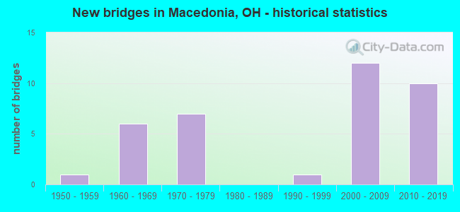
- New bridges - historical statistics
- 11950-1959
- 61960-1969
- 71970-1979
- 11990-1999
- 122000-2009
- 102010-2019


- Bridge Condition - Deck
- 72.2%Very good
- 16.7%Good
- 11.1%Satisfactory

- Bridge Condition - Superstructure
- 72.2%Very good
- 27.8%Good

- Bridge Condition - Substructure
- 77.8%Very good
- 22.2%Good

- Bridge Condition - Channel
- 61.5%Very good
- 23.1%Good
- 15.4%Satisfactory

- Bridge Condition - Culverts
- 50.0%Good
- 25.0%Satisfactory
- 25.0%Fair
Find on map >> Show street view
Structure Number: 7700709, Location: 1.46 MI S OF SR 82 (Lat: 41.294431, Lng: -81.512150), Route carried "on" structure: State highway 8, Year Built: 2007, Status: Open, Structure Length: 2.22m (7.28ft), Average Daily Traffic: 11,640 (year 2015), Truck Traffic: 7%, Average Future Daily Traffic: 16,156 (year 2035), Design Load: HS 25 or greater, Features Intersected: BRANDYWINE CREEK
Minimum Vertical Clearance: 30+ m (98+ ft), Kilometerpoint: 27.697, Lanes on structure: 2, Base Highway Network: Yes, Owner: State Highway Agency, Approaching Roadway Width: 15.2m (49.9ft), Skew: 2 degrees, Material/Design: Concrete continuous, Design/Construction: Slab, Number Of Spans In Main Unit: 3, Length of Maximum Span: 8.4m (27.6ft), Curb-To-Curb Width: 15.2m (49.9ft), Out-to-Out Width: 15.2m (49.9ft)
Condition: Deck: Good, Superstructure: Good, Substructure: Good, Channel: Very good, Operating Rating: 42.1 metric tons, Method Used To Determine Operating Rating: Load Factor (LF) rating reported by rating factor (RF) method using MS18 loading, Inventory Rating: 32.4 metric tons, Method Used To Determine Inventory Rating: Load Factor (LF) rating reported by rating factor (RF) method using MS18 loading, Structural Evaluation: Better than present minimum criteria, Deck Geometry: Superior to present desirable criteria, Waterway Adequacy: Superior to present desirable criteria, Approach Roadway Alignment: Equal to present desirable criteria, Designated Inspection Frequency: Every 24 months, Inspection Date: June 2021, Deck Structure Type: Concrete Cast-file-Place, Wearing Surface/Protective System: Wearing Surface: Monolithic Concrete, Deck Protection: Epoxy Coated Reinforcing
Find on map >> Show street view
Structure Number: 7700725, Location: 0.97 MI S OF SR 82 (Lat: 41.301019, Lng: -81.515950), Route carried "on" structure: State highway 8, Year Built: 1953, Status: Open, Structure Length: 1.01m (3.31ft), Average Daily Traffic: 51,105 (year 2015), Truck Traffic: 6%, Average Future Daily Traffic: 70,934 (year 2035), Design Load: H 20, Features Intersected: INDIAN CREEK
Minimum Vertical Clearance: 30+ m (98+ ft), Kilometerpoint: 28.485, Lanes on structure: 4, Base Highway Network: Yes, Owner: State Highway Agency, Approaching Roadway Width: 14.6m (47.9ft), Material/Design: Steel, Design/Construction: Culvert, Number Of Spans In Main Unit: 2, Length of Maximum Span: 4.3m (14.1ft)
Condition: Channel: Good, Culverts: Fair, Operating Rating: 42.1 metric tons, Method Used To Determine Operating Rating: Load Factor (LF) rating reported by rating factor (RF) method using MS18 loading, Inventory Rating: 32.4 metric tons, Method Used To Determine Inventory Rating: Load Factor (LF) rating reported by rating factor (RF) method using MS18 loading, Structural Evaluation: Somewhat better than minimum adequacy, Waterway Adequacy: Better than present minimum criteria, Approach Roadway Alignment: Better than present minimum criteria, Designated Inspection Frequency: Every 12 months, Inspection Date: June 2021
Find on map >> Show street view
Structure Number: 7700768, Location: 1.59 MI S OF SR 82 (Lat: 41.292781, Lng: -81.511389), Route carried "on" structure: Ramp State highway 8, Year Built: 2009, Status: Open, Structure Length: 28.97m (95.05ft), Average Daily Traffic: 37,980 (year 2011), Average Future Daily Traffic: 52,716 (year 2031), Design Load: HS 25 or greater, Features Intersected: RAMP OVER SR 8 AND CREEK
Minimum Vertical Clearance: 30+ m (98+ ft), Kilometerpoint: 27.504, Lanes on structure: 2, Lanes under structure: 2, Owner: State Highway Agency, Approaching Roadway Width: 14.0m (45.9ft), Material/Design: Steel continuous, Design/Construction: Stringer/Multi-beam, Number Of Spans In Main Unit: 6, Length of Maximum Span: 58.2m (190.9ft), Curb-To-Curb Width: 14.0m (45.9ft), Out-to-Out Width: 14.9m (48.9ft)
Condition: Deck: Very good, Superstructure: Very good, Substructure: Very good, Channel: Very good, Operating Rating: 71.3 metric tons, Method Used To Determine Operating Rating: Load Factor (LF) rating reported by rating factor (RF) method using MS18 loading, Inventory Rating: 42.1 metric tons, Method Used To Determine Inventory Rating: Load Factor (LF) rating reported by rating factor (RF) method using MS18 loading, Structural Evaluation: Equal to present desirable criteria, Deck Geometry: Superior to present desirable criteria, Underclear: High priority of corrective action, Waterway Adequacy: Superior to present desirable criteria, Approach Roadway Alignment: Equal to present desirable criteria, Designated Inspection Frequency: Every 12 months, Critical Feature Inspection Frequency: Every 24 months, Inspection Date: June 2021, Critical Feature Inspection Date: June 2021, Deck Structure Type: Concrete Cast-file-Place, Wearing Surface/Protective System: Wearing Surface: Monolithic Concrete, Membrane: Epoxy, Deck Protection: Epoxy Coated Reinforcing
Find on map >> Show street view
Structure Number: 7700776, Location: 1.1 MI S OF SR 82 (Lat: 41.298189, Lng: -81.518650), Route carried "on" structure: Ramp State highway 8, Year Built: 2009, Status: Open, Structure Length: 24.25m (79.56ft), Average Daily Traffic: 10,488 (year 2005), Truck Traffic: 21%, Average Future Daily Traffic: 14,557 (year 2025), Design Load: HS 25 or greater, Features Intersected: OVER HIGHLAND RD & CREEK
Minimum Vertical Clearance: 30+ m (98+ ft), Kilometerpoint: 28.534, Lanes on structure: 2, Lanes under structure: 3, Owner: State Highway Agency, Approaching Roadway Width: 14.0m (45.9ft), Skew: 7 degrees, Material/Design: Steel continuous, Design/Construction: Stringer/Multi-beam, Number Of Spans In Main Unit: 5, Length of Maximum Span: 54.9m (180.1ft), Curb-To-Curb Width: 14.0m (45.9ft), Out-to-Out Width: 14.9m (48.9ft)
Condition: Deck: Very good, Superstructure: Very good, Substructure: Very good, Channel: Very good, Operating Rating: 84.2 metric tons, Method Used To Determine Operating Rating: Load Factor (LF) rating reported by rating factor (RF) method using MS18 loading, Inventory Rating: 48.6 metric tons, Method Used To Determine Inventory Rating: Load Factor (LF) rating reported by rating factor (RF) method using MS18 loading, Structural Evaluation: Equal to present desirable criteria, Deck Geometry: Superior to present desirable criteria, Underclear: Equal to present minimum criteria, Waterway Adequacy: Superior to present desirable criteria, Approach Roadway Alignment: Equal to present desirable criteria, Designated Inspection Frequency: Every 24 months, Inspection Date: November 2021, Deck Structure Type: Concrete Cast-file-Place, Wearing Surface/Protective System: Wearing Surface: Monolithic Concrete, Membrane: Epoxy, Deck Protection: Epoxy Coated Reinforcing
Find on map >> Show street view
Structure Number: 7700784, Location: 1.44 MI S OF SR 82 (Lat: 41.294439, Lng: -81.513331), Route carried "on" structure: Ramp State highway 8, Year Built: 2009, Status: Open, Structure Length: 3.76m (12.34ft), Average Daily Traffic: 10,488 (year 2005), Average Future Daily Traffic: 14,557 (year 2025), Design Load: HS 25 or greater, Features Intersected: RAMP OVER BRANDYWINE CR
Minimum Vertical Clearance: 30+ m (98+ ft), Kilometerpoint: 27.745, Lanes on structure: 2, Owner: State Highway Agency, Approaching Roadway Width: 14.6m (47.9ft), Skew: 6 degrees, Material/Design: Steel, Design/Construction: Stringer/Multi-beam, Number Of Spans In Main Unit: 1, Length of Maximum Span: 36.6m (120.1ft), Curb-To-Curb Width: 14.6m (47.9ft), Out-to-Out Width: 15.5m (50.9ft)
Condition: Deck: Very good, Superstructure: Very good, Substructure: Very good, Channel: Very good, Operating Rating: 42.1 metric tons, Method Used To Determine Operating Rating: Load Factor (LF) rating reported by rating factor (RF) method using MS18 loading, Inventory Rating: 32.4 metric tons, Method Used To Determine Inventory Rating: Load Factor (LF) rating reported by rating factor (RF) method using MS18 loading, Structural Evaluation: Equal to present desirable criteria, Deck Geometry: Superior to present desirable criteria, Waterway Adequacy: Superior to present desirable criteria, Approach Roadway Alignment: Equal to present desirable criteria, Designated Inspection Frequency: Every 24 months, Inspection Date: November 2021, Deck Structure Type: Concrete Cast-file-Place, Wearing Surface/Protective System: Wearing Surface: Monolithic Concrete, Membrane: Epoxy, Deck Protection: Epoxy Coated Reinforcing
Find on map >> Show street view
Structure Number: 7700792, Location: 1.1 MI S OF SR 82 (Lat: 41.297900, Lng: -81.518950), Route carried "on" structure: Ramp State highway 8, Year Built: 2009, Status: Open, Structure Length: 23.48m (77.03ft), Average Daily Traffic: 10,488 (year 2005), Truck Traffic: 19%, Average Future Daily Traffic: 14,557 (year 2025), Design Load: HS 25 or greater, Features Intersected: OVER HIGHLAND RD & CREEK
Minimum Vertical Clearance: 30+ m (98+ ft), Kilometerpoint: 28.518, Lanes on structure: 2, Lanes under structure: 5, Owner: State Highway Agency, Approaching Roadway Width: 14.0m (45.9ft), Skew: 7 degrees, Material/Design: Steel continuous, Design/Construction: Stringer/Multi-beam, Number Of Spans In Main Unit: 5, Length of Maximum Span: 55.5m (182.1ft), Curb-To-Curb Width: 14.0m (45.9ft), Out-to-Out Width: 14.9m (48.9ft)
Condition: Deck: Very good, Superstructure: Good, Substructure: Very good, Channel: Very good, Operating Rating: 68.0 metric tons, Method Used To Determine Operating Rating: Load Factor (LF) rating reported by rating factor (RF) method using MS18 loading, Inventory Rating: 32.4 metric tons, Method Used To Determine Inventory Rating: Load Factor (LF) rating reported by rating factor (RF) method using MS18 loading, Structural Evaluation: Better than present minimum criteria, Deck Geometry: Superior to present desirable criteria, Underclear: High priority of corrective action, Waterway Adequacy: Superior to present desirable criteria, Approach Roadway Alignment: Equal to present desirable criteria, Designated Inspection Frequency: Every 12 months, Critical Feature Inspection Frequency: Every 24 months, Inspection Date: June 2021, Critical Feature Inspection Date: June 2021, Deck Structure Type: Concrete Cast-file-Place, Wearing Surface/Protective System: Wearing Surface: Monolithic Concrete, Membrane: Epoxy, Deck Protection: Epoxy Coated Reinforcing
Find on map >> Show street view
Structure Number: 7700806, Location: 1.46 MI S OF SR 82 (Lat: 41.294439, Lng: -81.512500), Route carried "on" structure: State highway 8, Year Built: 2007, Status: Open, Structure Length: 2.22m (7.28ft), Average Daily Traffic: 11,640 (year 2015), Truck Traffic: 7%, Average Future Daily Traffic: 16,156 (year 2035), Design Load: HS 25 or greater, Features Intersected: BRANDYWINE CREEK
Minimum Vertical Clearance: 30+ m (98+ ft), Kilometerpoint: 27.697, Lanes on structure: 2, Base Highway Network: Yes, Owner: State Highway Agency, Approaching Roadway Width: 13.4m (44.0ft), Skew: 2 degrees, Material/Design: Concrete, Design/Construction: Slab, Number Of Spans In Main Unit: 3, Length of Maximum Span: 8.4m (27.6ft), Curb-To-Curb Width: 15.2m (49.9ft), Out-to-Out Width: 15.2m (49.9ft)
Condition: Deck: Good, Superstructure: Good, Substructure: Good, Channel: Very good, Operating Rating: 42.1 metric tons, Method Used To Determine Operating Rating: Load Factor (LF) rating reported by rating factor (RF) method using MS18 loading, Inventory Rating: 32.4 metric tons, Method Used To Determine Inventory Rating: Load Factor (LF) rating reported by rating factor (RF) method using MS18 loading, Structural Evaluation: Better than present minimum criteria, Deck Geometry: Superior to present desirable criteria, Waterway Adequacy: Equal to present desirable criteria, Approach Roadway Alignment: Equal to present desirable criteria, Designated Inspection Frequency: Every 24 months, Inspection Date: June 2021, Deck Structure Type: Concrete Cast-file-Place, Wearing Surface/Protective System: Wearing Surface: Monolithic Concrete, Deck Protection: Epoxy Coated Reinforcing
Find on map >> Show street view
Structure Number: 7709218, Location: 0.70 MI S OF SR 8 (Lat: 41.293639, Lng: -81.522361), Route carried "on" structure: Interstate 271, Year Built: 1971, Year Reconstructed: 2007, Status: Open, Structure Length: 4.12m (13.52ft), Average Daily Traffic: 15,050 (year 2015), Truck Traffic: 17%, Average Future Daily Traffic: 20,889 (year 2035), Design Load: HS 25 or greater, Features Intersected: OVER AKRON CLEV RD CR-16
Minimum Vertical Clearance: 30+ m (98+ ft), Kilometerpoint: 17.944, Lanes on structure: 2, Lanes under structure: 2, Base Highway Network: Yes, Owner: State Highway Agency, Approaching Roadway Width: 13.7m (44.9ft), Skew: 2 degrees, Material/Design: Steel continuous, Design/Construction: Stringer/Multi-beam, Number Of Spans In Main Unit: 3, Length of Maximum Span: 16.5m (54.1ft), Curb-To-Curb Width: 13.4m (44.0ft), Out-to-Out Width: 14.3m (46.9ft)
Condition: Deck: Very good, Superstructure: Very good, Substructure: Very good, Operating Rating: 42.1 metric tons, Method Used To Determine Operating Rating: Allowable Stress (AS) rating reported by rating factor (RF) method using MS18 loading, Inventory Rating: 32.4 metric tons, Method Used To Determine Inventory Rating: Allowable Stress (AS) rating reported by rating factor (RF) method using MS18 loading, Structural Evaluation: Equal to present desirable criteria, Deck Geometry: Superior to present desirable criteria, Underclear: Meets minimum limits, Approach Roadway Alignment: Equal to present desirable criteria, Designated Inspection Frequency: Every 24 months, Inspection Date: October 2021, Deck Structure Type: Concrete Cast-file-Place, Wearing Surface/Protective System: Wearing Surface: Monolithic Concrete, Membrane: Epoxy, Deck Protection: Epoxy Coated Reinforcing
Find on map >> Show street view
Structure Number: 7709242, Location: 0.70 MI S OF SR 8 (Lat: 41.293350, Lng: -81.521919), Route carried "on" structure: Interstate 271, Year Built: 1971, Status: Open, Structure Length: 4.11m (13.48ft), Average Daily Traffic: 15,050 (year 2015), Truck Traffic: 17%, Average Future Daily Traffic: 20,889 (year 2035), Design Load: HS 20, Features Intersected: OVER AKRON CLEV RD CR-16
Minimum Vertical Clearance: 30+ m (98+ ft), Kilometerpoint: 17.944, Lanes on structure: 2, Lanes under structure: 2, Base Highway Network: Yes, Owner: State Highway Agency, Approaching Roadway Width: 14.9m (48.9ft), Skew: 2 degrees, Material/Design: Steel continuous, Design/Construction: Stringer/Multi-beam, Number Of Spans In Main Unit: 3, Length of Maximum Span: 16.5m (54.1ft), Curb-To-Curb Width: 11.8m (38.7ft), Out-to-Out Width: 12.8m (42.0ft)
Condition: Deck: Satisfactory, Superstructure: Good, Substructure: Very good, Operating Rating: 55.1 metric tons, Method Used To Determine Operating Rating: Load and Resistance Factor Rating (LRFR) rating reported by rating factor(RF) method using HL-93 loadings, Inventory Rating: 42.1 metric tons, Method Used To Determine Inventory Rating: Load and Resistance Factor Rating (LRFR) rating reported by rating factor(RF) method using HL-93 loadings, Structural Evaluation: Better than present minimum criteria, Deck Geometry: Equal to present minimum criteria, Underclear: Meets minimum limits, Approach Roadway Alignment: Equal to present desirable criteria, Designated Inspection Frequency: Every 12 months, Inspection Date: October 2021, Deck Structure Type: Concrete Cast-file-Place, Wearing Surface/Protective System: Wearing Surface: Integral Concrete
Find on map >> Show street view
Structure Number: 7709277, Location: 0.64 MI S OF SR 8 (Lat: 41.294211, Lng: -81.522089), Route carried "on" structure: Interstate 271, Year Built: 1971, Year Reconstructed: 2007, Status: Open, Structure Length: 4.91m (16.11ft), Average Daily Traffic: 15,050 (year 2015), Truck Traffic: 17%, Average Future Daily Traffic: 20,889 (year 2035), Design Load: HS 25 or greater, Features Intersected: BRANDYWINE CREEK
Minimum Vertical Clearance: 30+ m (98+ ft), Kilometerpoint: 18.025, Lanes on structure: 2, Base Highway Network: Yes, Owner: State Highway Agency, Approaching Roadway Width: 14.9m (48.9ft), Skew: 1 degrees, Material/Design: Steel continuous, Design/Construction: Stringer/Multi-beam, Number Of Spans In Main Unit: 3, Length of Maximum Span: 18.3m (60.0ft), Curb-To-Curb Width: 13.4m (44.0ft), Out-to-Out Width: 14.3m (46.9ft)
Condition: Deck: Very good, Superstructure: Very good, Substructure: Very good, Channel: Very good, Operating Rating: 42.1 metric tons, Method Used To Determine Operating Rating: Allowable Stress (AS) rating reported by rating factor (RF) method using MS18 loading, Inventory Rating: 32.4 metric tons, Method Used To Determine Inventory Rating: Allowable Stress (AS) rating reported by rating factor (RF) method using MS18 loading, Structural Evaluation: Equal to present desirable criteria, Deck Geometry: Superior to present desirable criteria, Waterway Adequacy: Equal to present desirable criteria, Approach Roadway Alignment: Equal to present desirable criteria, Designated Inspection Frequency: Every 24 months, Inspection Date: October 2021, Deck Structure Type: Concrete Cast-file-Place, Wearing Surface/Protective System: Wearing Surface: Monolithic Concrete, Membrane: Epoxy, Deck Protection: Epoxy Coated Reinforcing
Find on map >> Show street view
Structure Number: 7709307, Location: 0.64 MI S OF SR 8 (Lat: 41.294150, Lng: -81.521561), Route carried "on" structure: Interstate 271, Year Built: 1971, Status: Open, Structure Length: 4.91m (16.11ft), Average Daily Traffic: 15,050 (year 2015), Truck Traffic: 17%, Average Future Daily Traffic: 20,889 (year 2035), Design Load: HS 20, Features Intersected: BRANDYWINE CREEK
Minimum Vertical Clearance: 30+ m (98+ ft), Kilometerpoint: 18.025, Lanes on structure: 2, Base Highway Network: Yes, Owner: State Highway Agency, Approaching Roadway Width: 14.9m (48.9ft), Material/Design: Steel continuous, Design/Construction: Stringer/Multi-beam, Number Of Spans In Main Unit: 3, Length of Maximum Span: 18.3m (60.0ft), Curb-To-Curb Width: 11.8m (38.7ft), Out-to-Out Width: 12.8m (42.0ft)
Condition: Deck: Satisfactory, Superstructure: Very good, Substructure: Good, Channel: Very good, Operating Rating: 42.1 metric tons, Method Used To Determine Operating Rating: Allowable Stress (AS) rating reported by rating factor (RF) method using MS18 loading, Inventory Rating: 32.4 metric tons, Method Used To Determine Inventory Rating: Allowable Stress (AS) rating reported by rating factor (RF) method using MS18 loading, Structural Evaluation: Better than present minimum criteria, Deck Geometry: Equal to present minimum criteria, Waterway Adequacy: Equal to present desirable criteria, Approach Roadway Alignment: Equal to present desirable criteria, Designated Inspection Frequency: Every 12 months, Inspection Date: October 2021, Deck Structure Type: Other, Wearing Surface/Protective System: Wearing Surface: Integral Concrete
Find on map >> Show street view
Structure Number: 7709331, Location: JCT OF IR 271 AND SR 8 (Lat: 41.303431, Lng: -81.517811), Route carried "on" structure: Interstate 271, Year Built: 1967, Year Reconstructed: 2008, Status: Open, Structure Length: 10.32m (33.86ft), Average Daily Traffic: 20,052 (year 2015), Truck Traffic: 16%, Average Future Daily Traffic: 27,832 (year 2035), Design Load: HS 25 or greater, Features Intersected: I 271 SB OVER SR 8
Minimum Vertical Clearance: 30+ m (98+ ft), Kilometerpoint: 19.039, Lanes on structure: 5, Lanes under structure: 4, Base Highway Network: Yes, Owner: State Highway Agency, Approaching Roadway Width: 35.2m (115.5ft), Skew: 4 degrees, Material/Design: Steel continuous, Design/Construction: Stringer/Multi-beam, Number Of Spans In Main Unit: 4, Length of Maximum Span: 36.6m (120.1ft), Curb-To-Curb Width: 35.2m (115.5ft), Out-to-Out Width: 36.1m (118.4ft)
Condition: Deck: Very good, Superstructure: Very good, Substructure: Very good, Operating Rating: 42.1 metric tons, Method Used To Determine Operating Rating: Allowable Stress (AS) rating reported by rating factor (RF) method using MS18 loading, Inventory Rating: 32.4 metric tons, Method Used To Determine Inventory Rating: Allowable Stress (AS) rating reported by rating factor (RF) method using MS18 loading, Structural Evaluation: Equal to present desirable criteria, Deck Geometry: Superior to present desirable criteria, Underclear: High priority of corrective action, Approach Roadway Alignment: Equal to present desirable criteria, Designated Inspection Frequency: Every 24 months, Inspection Date: October 2021, Deck Structure Type: Concrete Cast-file-Place, Wearing Surface/Protective System: Wearing Surface: Monolithic Concrete, Membrane: Epoxy, Deck Protection: Epoxy Coated Reinforcing
Find on map >> Show street view
Structure Number: 7709366, Location: JCT OF IR 271 AND SR 8 (Lat: 41.302981, Lng: -81.517539), Route carried "on" structure: Interstate 271, Year Built: 1967, Year Reconstructed: 2008, Status: Open, Structure Length: 10.33m (33.89ft), Average Daily Traffic: 20,052 (year 2015), Truck Traffic: 16%, Average Future Daily Traffic: 27,832 (year 2035), Design Load: HS 25 or greater, Features Intersected: I 271 NB OVER SR 8
Minimum Vertical Clearance: 30+ m (98+ ft), Kilometerpoint: 19.039, Lanes on structure: 3, Lanes under structure: 4, Base Highway Network: Yes, Owner: State Highway Agency, Approaching Roadway Width: 27.1m (88.9ft), Skew: 4 degrees, Material/Design: Steel continuous, Design/Construction: Stringer/Multi-beam, Number Of Spans In Main Unit: 4, Length of Maximum Span: 35.1m (115.2ft), Curb-To-Curb Width: 27.1m (88.9ft), Out-to-Out Width: 28.0m (91.9ft)
Condition: Deck: Very good, Superstructure: Very good, Substructure: Very good, Operating Rating: 42.1 metric tons, Method Used To Determine Operating Rating: Allowable Stress (AS) rating reported by rating factor (RF) method using MS18 loading, Inventory Rating: 32.4 metric tons, Method Used To Determine Inventory Rating: Allowable Stress (AS) rating reported by rating factor (RF) method using MS18 loading, Structural Evaluation: Equal to present desirable criteria, Deck Geometry: Superior to present desirable criteria, Underclear: Equal to present minimum criteria, Approach Roadway Alignment: Equal to present desirable criteria, Designated Inspection Frequency: Every 24 months, Inspection Date: October 2021, Deck Structure Type: Concrete Cast-file-Place, Wearing Surface/Protective System: Wearing Surface: Monolithic Concrete, Membrane: Epoxy, Deck Protection: Epoxy Coated Reinforcing
Find on map >> Show street view
Structure Number: 7710001, Location: 1.55 Mi N of SR 82 (Lat: 41.334811, Lng: -81.515150), Route carried "on" structure: Interstate 271, Year Built: 2015, Status: Open, Structure Length: 14.57m (47.80ft), Average Daily Traffic: 64,980 (year 2015), Truck Traffic: 15%, Average Future Daily Traffic: 75,299 (year 2035), Design Load: HL 93, Features Intersected: Over NS RR & Ledge Rd
Minimum Vertical Clearance: 30+ m (98+ ft), Kilometerpoint: 22.740, Lanes on structure: 3, Lanes under structure: 2, Base Highway Network: Yes, Owner: State Highway Agency, Approaching Roadway Width: 11.0m (36.1ft), Skew: 5 degrees, Material/Design: Steel continuous, Design/Construction: Stringer/Multi-beam, Number Of Spans In Main Unit: 3, Length of Maximum Span: 60.4m (198.2ft), Curb-To-Curb Width: 18.3m (60.0ft), Out-to-Out Width: 19.3m (63.3ft)
Condition: Deck: Very good, Superstructure: Very good, Substructure: Very good, Operating Rating: 42.1 metric tons, Method Used To Determine Operating Rating: Load and Resistance Factor Rating (LRFR) rating reported by rating factor(RF) method using HL-93 loadings, Inventory Rating: 32.4 metric tons, Method Used To Determine Inventory Rating: Load and Resistance Factor Rating (LRFR) rating reported by rating factor(RF) method using HL-93 loadings, Structural Evaluation: Equal to present desirable criteria, Deck Geometry: Better than present minimum criteria, Underclear: Better than present minimum criteria, Approach Roadway Alignment: Equal to present desirable criteria, Length Of Structure Improvement: 14.57m (47.80ft), Designated Inspection Frequency: Every 24 months, Inspection Date: October 2021, Total Project Cost: $47,868,000 ( Estimate for 2014), Deck Structure Type: Concrete Cast-file-Place, Wearing Surface/Protective System: Wearing Surface: Monolithic Concrete, Deck Protection: Epoxy Coated Reinforcing
Find on map >> Show street view
Structure Number: 7710002, Location: JCT of IR 271 and SR 82 (Lat: 41.313889, Lng: -81.513061), Route carried "on" structure: Interstate 271, Year Built: 2015, Status: Open, Structure Length: 3.52m (11.55ft), Average Daily Traffic: 51,830 (year 2015), Truck Traffic: 17%, Average Future Daily Traffic: 58,650 (year 2035), Design Load: HL 93, Features Intersected: IR 271 SB over SR 82
Minimum Vertical Clearance: 30+ m (98+ ft), Kilometerpoint: 20.310, Lanes on structure: 3, Lanes under structure: 2, Base Highway Network: Yes, Owner: State Highway Agency, Approaching Roadway Width: 11.0m (36.1ft), Material/Design: Prestressed concrete, Design/Construction: Stringer/Multi-beam, Number Of Spans In Main Unit: 1, Length of Maximum Span: 33.9m (111.2ft), Curb-To-Curb Width: 18.3m (60.0ft), Out-to-Out Width: 19.3m (63.3ft)
Condition: Deck: Very good, Superstructure: Very good, Substructure: Very good, Operating Rating: 71.3 metric tons, Method Used To Determine Operating Rating: Load and Resistance Factor Rating (LRFR) rating reported by rating factor(RF) method using HL-93 loadings, Inventory Rating: 32.4 metric tons, Method Used To Determine Inventory Rating: Load and Resistance Factor Rating (LRFR) rating reported by rating factor(RF) method using HL-93 loadings, Structural Evaluation: Equal to present desirable criteria, Deck Geometry: Better than present minimum criteria, Underclear: Meets minimum limits, Approach Roadway Alignment: Equal to present desirable criteria, Length Of Structure Improvement: 3.51m (11.52ft), Designated Inspection Frequency: Every 24 months, Inspection Date: October 2021, Total Project Cost: $445,496,000, Deck Structure Type: Concrete Cast-file-Place, Wearing Surface/Protective System: Wearing Surface: Monolithic Concrete, Deck Protection: Epoxy Coated Reinforcing
Find on map >> Show street view
Structure Number: 7710003, Location: JCT of IR 271 and SR 82 (Lat: 41.313889, Lng: -81.513061), Route carried "on" structure: Interstate 271, Year Built: 2015, Status: Open, Structure Length: 3.70m (12.14ft), Average Daily Traffic: 51,830 (year 2015), Truck Traffic: 17%, Average Future Daily Traffic: 58,650 (year 2035), Design Load: HL 93, Features Intersected: IR 271 NB over SR 82
Minimum Vertical Clearance: 30+ m (98+ ft), Kilometerpoint: 20.310, Lanes on structure: 3, Lanes under structure: 2, Base Highway Network: Yes, Owner: State Highway Agency, Approaching Roadway Width: 11.0m (36.1ft), Material/Design: Prestressed concrete, Design/Construction: Stringer/Multi-beam, Number Of Spans In Main Unit: 1, Length of Maximum Span: 36.5m (119.8ft), Curb-To-Curb Width: 18.3m (60.0ft), Out-to-Out Width: 19.3m (63.3ft)
Condition: Deck: Very good, Superstructure: Very good, Substructure: Very good, Operating Rating: 68.0 metric tons, Method Used To Determine Operating Rating: Load and Resistance Factor Rating (LRFR) rating reported by rating factor(RF) method using HL-93 loadings, Inventory Rating: 35.6 metric tons, Method Used To Determine Inventory Rating: Load and Resistance Factor Rating (LRFR) rating reported by rating factor(RF) method using HL-93 loadings, Structural Evaluation: Equal to present desirable criteria, Deck Geometry: Better than present minimum criteria, Underclear: Meets minimum limits, Approach Roadway Alignment: Equal to present desirable criteria, Length Of Structure Improvement: 3.70m (12.14ft), Designated Inspection Frequency: Every 24 months, Inspection Date: October 2021, Total Project Cost: $47,868,000 ( Estimate for 2014), Deck Structure Type: Concrete Cast-file-Place, Wearing Surface/Protective System: Wearing Surface: Monolithic Concrete, Deck Protection: Epoxy Coated Reinforcing
Find on map >> Show street view
Structure Number: 7710151, Location: 3.98 MI N OF SR 82 (Lat: 41.349761, Lng: -81.508689), Route carried "on" structure: Interstate 480, Year Built: 2019, Status: Open, Structure Length: 4.48m (14.70ft), Average Daily Traffic: 23,010 (year 2017), Truck Traffic: 11%, Average Future Daily Traffic: 27,520 (year 2037), Design Load: HL 93, Features Intersected: OVER N BEDFORD RD CR-679
Minimum Vertical Clearance: 30+ m (98+ ft), Kilometerpoint: 0.177, Lanes on structure: 2, Lanes under structure: 2, Base Highway Network: Yes, Owner: State Highway Agency, Approaching Roadway Width: 14.6m (47.9ft), Skew: 1 degrees, Material/Design: Steel continuous, Design/Construction: Stringer/Multi-beam, Number Of Spans In Main Unit: 3, Length of Maximum Span: 17.1m (56.1ft), Curb-To-Curb Width: 15.9m (52.2ft), Out-to-Out Width: 16.9m (55.4ft)
Condition: Deck: Very good, Superstructure: Very good, Substructure: Very good, Operating Rating: 77.8 metric tons, Method Used To Determine Operating Rating: Load and Resistance Factor Rating (LRFR) rating reported by rating factor(RF) method using HL-93 loadings, Inventory Rating: 58.3 metric tons, Method Used To Determine Inventory Rating: Load and Resistance Factor Rating (LRFR) rating reported by rating factor(RF) method using HL-93 loadings, Structural Evaluation: Equal to present desirable criteria, Deck Geometry: Superior to present desirable criteria, Underclear: Superior to present desirable criteria, Approach Roadway Alignment: Equal to present desirable criteria, Length Of Structure Improvement: 4.48m (14.70ft), Designated Inspection Frequency: Every 12 months, Inspection Date: August 2021, Total Project Cost: $119,988,000 ( Estimate for 2016), Deck Structure Type: Concrete Cast-file-Place, Wearing Surface/Protective System: Wearing Surface: Monolithic Concrete, Deck Protection: Epoxy Coated Reinforcing
Find on map >> Show street view
Structure Number: 7710178, Location: 3.98 MI N OF SR 82 (Lat: 41.349269, Lng: -81.508989), Route carried "on" structure: Interstate 480, Year Built: 1965, Status: Open, Structure Length: 4.42m (14.50ft), Average Daily Traffic: 21,896 (year 2015), Truck Traffic: 9%, Average Future Daily Traffic: 30,392 (year 2035), Design Load: HS 20, Features Intersected: OVER BEDFORD RD CR-679
Minimum Vertical Clearance: 30+ m (98+ ft), Kilometerpoint: 0.177, Lanes on structure: 2, Lanes under structure: 2, Base Highway Network: Yes, Owner: State Highway Agency, Approaching Roadway Width: 12.2m (40.0ft), Skew: 1 degrees, Material/Design: Concrete continuous, Design/Construction: Slab, Number Of Spans In Main Unit: 3, Length of Maximum Span: 21.9m (71.9ft), Curb-To-Curb Width: 12.4m (40.7ft), Out-to-Out Width: 13.4m (44.0ft)
Condition: Deck: Good, Superstructure: Good, Substructure: Good, Operating Rating: 42.1 metric tons, Method Used To Determine Operating Rating: Allowable Stress (AS) rating reported by rating factor (RF) method using MS18 loading, Inventory Rating: 32.4 metric tons, Method Used To Determine Inventory Rating: Allowable Stress (AS) rating reported by rating factor (RF) method using MS18 loading, Structural Evaluation: Better than present minimum criteria, Deck Geometry: Better than present minimum criteria, Underclear: Meets minimum limits, Approach Roadway Alignment: Equal to present desirable criteria, Designated Inspection Frequency: Every 24 months, Inspection Date: August 2021, Deck Structure Type: Concrete Cast-file-Place, Wearing Surface/Protective System: Wearing Surface: Integral Concrete, Membrane: Epoxy
Find on map >> Show street view
Structure Number: 7742045, Location: 700 FT S OF SR82 (Lat: 41.311831, Lng: -81.509631), Route carried "on" structure: City street M0113, Year Built: 1997, Status: Open, Structure Length: 0.76m (2.49ft), Average Daily Traffic: 2,925 (year 1998), Truck Traffic: 1%, Average Future Daily Traffic: 4,060 (year 2018), Design Load: HS 20+Mod, Features Intersected: INDIAN CREEK, Facility Carried by Structure: BEDFORD RD
Minimum Vertical Clearance: 30+ m (98+ ft), Kilometerpoint: 1.448, Lanes on structure: 2, Owner: County Highway Agency, Approaching Roadway Width: 8.5m (27.9ft), Skew: 3 degrees, Material/Design: Concrete, Design/Construction: Culvert, Number Of Spans In Main Unit: 1, Length of Maximum Span: 7.3m (24.0ft)
Condition: Channel: Satisfactory, Culverts: Satisfactory, Operating Rating: 68.0 metric tons, Method Used To Determine Operating Rating: Load Factor (LF) rating reported by rating factor (RF) method using MS18 loading, Inventory Rating: 42.1 metric tons, Method Used To Determine Inventory Rating: Load Factor (LF) rating reported by rating factor (RF) method using MS18 loading, Structural Evaluation: Equal to present minimum criteria, Waterway Adequacy: Better than present minimum criteria, Approach Roadway Alignment: Equal to present desirable criteria, Designated Inspection Frequency: Every 12 months, Inspection Date: June 2021, Deck Structure Type: Concrete Cast-file-Place, Wearing Surface/Protective System: Wearing Surface: Bituminous
Find on map >> Show street view
Structure Number: 7762, Location: 235 FT E OF N BEDFROD TRL (Lat: 41.331669, Lng: -81.508131), Route carried "on" structure: City street 2761Q, Year Built: 2006, Status: Open, Structure Length: 0.78m (2.56ft), Average Daily Traffic: 200 (year 2020), Truck Traffic: 3%, Average Future Daily Traffic: 280 (year 2040), Design Load: HS 20+Mod, Features Intersected: INDIAN CREEK, Facility Carried by Structure: NAVAJO TRAIL
Minimum Vertical Clearance: 30+ m (98+ ft), Kilometerpoint: 0.071, Lanes on structure: 2, Owner: City or Municipal Highway Agency, Approaching Roadway Width: 7.3m (24.0ft), Material/Design: Concrete, Design/Construction: Culvert, Number Of Spans In Main Unit: 1, Length of Maximum Span: 7.3m (24.0ft)
Condition: Channel: Good, Culverts: Good, Operating Rating: 38.9 metric tons, Method Used To Determine Operating Rating: Load and Resistance Factor Rating (LRFR) rating reported by rating factor(RF) method using HL-93 loadings, Inventory Rating: 32.4 metric tons, Method Used To Determine Inventory Rating: Load and Resistance Factor Rating (LRFR) rating reported by rating factor(RF) method using HL-93 loadings, Structural Evaluation: Better than present minimum criteria, Waterway Adequacy: Equal to present desirable criteria, Approach Roadway Alignment: Equal to present desirable criteria, Designated Inspection Frequency: Every 24 months, Inspection Date: November 2021
Find on map >> Show street view
Structure Number: 7762002, Location: 0.2 MI E OF N BEDFROD TRL (Lat: 41.324311, Lng: -81.505131), Route carried "on" structure: City street 2771C, Year Built: 2017, Status: Open, Structure Length: 1.01m (3.31ft), Average Daily Traffic: 200 (year 2020), Truck Traffic: 3%, Average Future Daily Traffic: 2,775 (year 2040), Design Load: HL 93, Features Intersected: INDIAN CREEK, Facility Carried by Structure: SIOUX LANE
Minimum Vertical Clearance: 30+ m (98+ ft), Kilometerpoint: 0.315, Lanes on structure: 2, Owner: City or Municipal Highway Agency, Approaching Roadway Width: 7.3m (24.0ft), Material/Design: Concrete, Design/Construction: Frame, Number Of Spans In Main Unit: 1, Length of Maximum Span: 9.4m (30.8ft), Curb or Sidewalk Widths: Left: 1.5m (4.9ft), Right: 0.0m, Curb-To-Curb Width: 7.9m (25.9ft), Out-to-Out Width: 18.3m (60.0ft)
Condition: Deck: Very good, Superstructure: Very good, Substructure: Very good, Channel: Good, Operating Rating: 38.9 metric tons, Method Used To Determine Operating Rating: Load and Resistance Factor Rating (LRFR) rating reported by rating factor(RF) method using HL-93 loadings, Inventory Rating: 32.4 metric tons, Method Used To Determine Inventory Rating: Load and Resistance Factor Rating (LRFR) rating reported by rating factor(RF) method using HL-93 loadings, Structural Evaluation: Equal to present desirable criteria, Deck Geometry: Somewhat better than minimum adequacy, Waterway Adequacy: Superior to present desirable criteria, Approach Roadway Alignment: Equal to present desirable criteria, Designated Inspection Frequency: Every 24 months, Inspection Date: November 2021, Deck Structure Type: Concrete Cast-file-Place, Wearing Surface/Protective System: Wearing Surface: Bituminous, Membrane: Preformed Fabric, Deck Protection: Epoxy Coated Reinforcing
Find on map >> Show street view
Structure Number: 7762006, Location: 0.2 MI W OF S BEDFROD TRL (Lat: 41.303919, Lng: -81.512400), Route carried "on" structure: City street BLUEJ, Year Built: 1970, Status: Open, Structure Length: 0.90m (2.95ft), Average Daily Traffic: 200 (year 2020), Truck Traffic: 3%, Average Future Daily Traffic: 2,775 (year 2040), Design Load: HS 20, Features Intersected: INDIAN CREEK, Facility Carried by Structure: BLUE JAY TRAIL
Minimum Vertical Clearance: 30+ m (98+ ft), Kilometerpoint: 0.293, Lanes on structure: 2, Owner: City or Municipal Highway Agency, Approaching Roadway Width: 7.3m (24.0ft), Material/Design: Steel, Design/Construction: Culvert, Number Of Spans In Main Unit: 2, Length of Maximum Span: 3.7m (12.1ft)
Condition: Channel: Satisfactory, Culverts: Good, Operating Rating: 38.9 metric tons, Method Used To Determine Operating Rating: Load and Resistance Factor Rating (LRFR) rating reported by rating factor(RF) method using HL-93 loadings, Inventory Rating: 29.2 metric tons, Method Used To Determine Inventory Rating: Load and Resistance Factor Rating (LRFR) rating reported by rating factor(RF) method using HL-93 loadings, Structural Evaluation: Better than present minimum criteria, Waterway Adequacy: Superior to present desirable criteria, Approach Roadway Alignment: Equal to present desirable criteria, Designated Inspection Frequency: Every 24 months, Inspection Date: November 2021
Find on map >> Show street view
Structure Number: 7700768, Location: 1.59 MI S OF SR 82 (Lat: 41.292781, Lng: -81.511389), Route carried "under" structure: State highway 8, Year Built: 2009, Structure Length: 0. m, Average Daily Traffic: 60,226 (year 2015), Truck Traffic: 4%, Features Intersected: RAMP A TO I-271 N
Minimum Vertical Clearance: 5.23m (17.16ft), Kilometerpoint: 27.504, Lanes on structure: 2, Lanes under structure: 2, Material/Design: Steel continuous, Design/Construction: Stringer/Multi-beam, Length of Maximum Span: 58.2m (190.9ft)
Find on map >> Show street view
Structure Number: 7700776, Location: 1.1 MI S OF SR 82 (Lat: 41.298189, Lng: -81.518650), Route carried "under" structure: County highway 111, Year Built: 2009, Structure Length: 0. m, Average Daily Traffic: 16,025 (year 2015), Truck Traffic: 5%, Features Intersected: SR 8, Facility Carried by Structure: SR 8 NB TO I-271 N
Minimum Vertical Clearance: 9.88m (32.41ft), Kilometerpoint: 4.490, Lanes on structure: 2, Lanes under structure: 3, Material/Design: Steel continuous, Design/Construction: Stringer/Multi-beam, Length of Maximum Span: 54.9m (180.1ft)
Find on map >> Show street view
Structure Number: 7700792, Location: 1.1 MI S OF SR 82 (Lat: 41.297900, Lng: -81.518950), Route carried "under" structure: Interstate 271, Year Built: 2009, Structure Length: 0. m, Average Daily Traffic: 30,099 (year 2015), Truck Traffic: 17%, Features Intersected: I-271 SB TO SR 8 SB
Minimum Vertical Clearance: 5.61m (18.41ft), Kilometerpoint: 19.071, Lanes on structure: 2, Lanes under structure: 5, Material/Design: Steel continuous, Design/Construction: Stringer/Multi-beam, Length of Maximum Span: 55.5m (182.1ft)
Find on map >> Show street view
Structure Number: 7700792, Location: 1.1 MI S OF SR 82 (Lat: 41.297900, Lng: -81.518950), Route carried "under" structure: Interstate 271, Year Built: 2009, Structure Length: 0. m, Average Daily Traffic: 29,110 (year 2013), Truck Traffic: 14%, Features Intersected: I-271 SB TO SR 8 SB
Minimum Vertical Clearance: 5.33m (17.49ft), Kilometerpoint: 19.055, Lanes on structure: 2, Lanes under structure: 5, Material/Design: Steel continuous, Design/Construction: Stringer/Multi-beam, Length of Maximum Span: 55.5m (182.1ft)
Find on map >> Show street view
Structure Number: 7700792, Location: 1.1 MI S OF SR 82 (Lat: 41.297900, Lng: -81.518950), Route carried "under" structure: County highway 111, Year Built: 2009, Structure Length: 0. m, Features Intersected: I-271 SB TO SR 8 SB, Facility Carried by Structure: I-271 SB TO SR 8 S
Minimum Vertical Clearance: 9.37m (30.74ft), Kilometerpoint: 4.619, Lanes on structure: 2, Lanes under structure: 5, Material/Design: Steel continuous, Design/Construction: Stringer/Multi-beam, Length of Maximum Span: 55.5m (182.1ft)
Find on map >> Show street view
Structure Number: 7709218, Location: 0.70 MI S OF SR 8 (Lat: 41.293639, Lng: -81.522361), Route carried "under" structure: County highway 16, Year Built: 1971, Structure Length: 0. m, Average Daily Traffic: 6,583 (year 2015), Truck Traffic: 7%, Features Intersected: I-271, Facility Carried by Structure: I.R. 271
Minimum Vertical Clearance: 4.67m (15.32ft), Kilometerpoint: 22.370, Lanes on structure: 2, Lanes under structure: 2, Material/Design: Steel continuous, Design/Construction: Stringer/Multi-beam, Length of Maximum Span: 16.5m (54.1ft)
Find on map >> Show street view
Structure Number: 7709242, Location: 0.70 MI S OF SR 8 (Lat: 41.293350, Lng: -81.521919), Route carried "under" structure: County highway 16, Year Built: 1971, Structure Length: 0. m, Average Daily Traffic: 6,583 (year 2015), Truck Traffic: 7%, Features Intersected: I-271, Facility Carried by Structure: I.R. 271 (NB)
Minimum Vertical Clearance: 4.72m (15.49ft), Kilometerpoint: 22.338, Lanes on structure: 2, Lanes under structure: 2, Material/Design: Steel continuous, Design/Construction: Stringer/Multi-beam, Length of Maximum Span: 16.5m (54.1ft)
Find on map >> Show street view
Structure Number: 7709331, Location: JCT OF IR 271 AND SR 8 (Lat: 41.303431, Lng: -81.517811), Route carried "under" structure: State highway 8, Year Built: 1967, Structure Length: 0. m, Average Daily Traffic: 34,131 (year 2015), Truck Traffic: 6%, Features Intersected: I-271 SB, Facility Carried by Structure: I.R. 271
Minimum Vertical Clearance: 4.55m (14.93ft), Kilometerpoint: 28.823, Lanes on structure: 5, Lanes under structure: 4, Material/Design: Steel continuous, Design/Construction: Stringer/Multi-beam, Length of Maximum Span: 36.6m (120.1ft)
Find on map >> Show street view
Structure Number: 7709366, Location: JCT OF IR 271 AND SR 8 (Lat: 41.302981, Lng: -81.517539), Route carried "under" structure: State highway 8, Year Built: 1967, Structure Length: 0. m, Average Daily Traffic: 34,131 (year 2015), Truck Traffic: 6%, Features Intersected: I-271 NB, Facility Carried by Structure: I.R. 271
Minimum Vertical Clearance: 5.23m (17.16ft), Kilometerpoint: 28.775, Lanes on structure: 3, Lanes under structure: 4, Material/Design: Steel continuous, Design/Construction: Stringer/Multi-beam, Length of Maximum Span: 35.1m (115.2ft)
Find on map >> Show street view
Structure Number: 771, Location: 1.55 Mi N of SR 82 (Lat: 41.335239, Lng: -81.515319), Route carried "under" structure: City street LEDGE, Year Built: 2015, Structure Length: 0. m, Average Daily Traffic: 3,800 (year 1974), Features Intersected: LEDGE ROAD, Facility Carried by Structure: IR 271L
Minimum Vertical Clearance: 7.06m (23.16ft), Kilometerpoint: 0.467, Lanes on structure: 3, Lanes under structure: 2, Material/Design: Steel continuous, Design/Construction: Stringer/Multi-beam, Length of Maximum Span: 65.6m (215.2ft)
Find on map >> Show street view
Structure Number: 7710001, Location: 1.55 Mi N of SR 82 (Lat: 41.334811, Lng: -81.515150), Route carried "under" structure: City street LEDGE, Year Built: 2015, Structure Length: 0. m, Average Daily Traffic: 3,800 (year 1974), Features Intersected: LEDGE ROAD, Facility Carried by Structure: IR 271R
Minimum Vertical Clearance: 7.06m (23.16ft), Kilometerpoint: 1.432, Lanes on structure: 3, Lanes under structure: 2, Material/Design: Steel continuous, Design/Construction: Stringer/Multi-beam, Length of Maximum Span: 60.4m (198.2ft)
Find on map >> Show street view
Structure Number: 7710002, Location: JCT of IR 271 and SR 82 (Lat: 41.313889, Lng: -81.513061), Route carried "under" structure: State highway 82, Year Built: 2015, Structure Length: 0. m, Average Daily Traffic: 16,232 (year 2015), Truck Traffic: 6%, Features Intersected: IR-271, Facility Carried by Structure: IR 271
Minimum Vertical Clearance: 4.80m (15.75ft), Kilometerpoint: 6.437, Lanes on structure: 3, Lanes under structure: 2, Material/Design: Prestressed concrete, Design/Construction: Stringer/Multi-beam, Length of Maximum Span: 33.9m (111.2ft)
Find on map >> Show street view
Structure Number: 7710003, Location: JCT of IR 271 and SR 82 (Lat: 41.313889, Lng: -81.513061), Route carried "under" structure: State highway 82, Year Built: 2015, Structure Length: 0. m, Average Daily Traffic: 16,232 (year 2015), Truck Traffic: 6%, Features Intersected: IR 271, Facility Carried by Structure: IR 271
Minimum Vertical Clearance: 4.80m (15.75ft), Kilometerpoint: 6.470, Lanes on structure: 3, Lanes under structure: 2, Material/Design: Prestressed concrete, Design/Construction: Stringer/Multi-beam, Length of Maximum Span: 36.5m (119.8ft)
Find on map >> Show street view
Structure Number: 7710151, Location: 3.98 MI N OF SR 82 (Lat: 41.349761, Lng: -81.508689), Route carried "under" structure: County highway 679, Year Built: 2019, Structure Length: 0. m, Average Daily Traffic: 4,105 (year 2015), Truck Traffic: 5%, Features Intersected: IR - 480
Minimum Vertical Clearance: 5.24m (17.19ft), Kilometerpoint: 3.991, Lanes on structure: 2, Lanes under structure: 2, Material/Design: Steel continuous, Design/Construction: Stringer/Multi-beam, Length of Maximum Span: 17.1m (56.1ft)
Find on map >> Show street view
Structure Number: 7710178, Location: 3.98 MI N OF SR 82 (Lat: 41.349269, Lng: -81.508989), Route carried "under" structure: County highway 679, Year Built: 1965, Structure Length: 0. m, Average Daily Traffic: 4,105 (year 2015), Truck Traffic: 5%, Features Intersected: I-480, Facility Carried by Structure: I.R. 480 EB
Minimum Vertical Clearance: 4.88m (16.01ft), Kilometerpoint: 3.943, Lanes on structure: 2, Lanes under structure: 2, Material/Design: Concrete continuous, Design/Construction: Slab, Length of Maximum Span: 21.9m (71.9ft)