Bridge Statistics for Lutz, Florida (FL)
Condition, Traffic, Stress, Structural Evaluation, Project Costs
- National Bridge Inventory (NBI) Statistics
- 14Number of bridges
- 177ft / 54.0mTotal length
- 616,490Total average daily traffic
- 77,539Total average daily truck traffic
- National Bridge Inventory (NBI) Registered Bridges for Lutz
- No street view available for this location
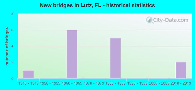
- New bridges - historical statistics
- 11940-1949
- 61960-1969
- 51980-1989
- 22010-2019

- Reconstructed bridges - Historical Statistics
- 31980-1989
- 01990-1999
- 22000-2009


- Bridge Condition - Deck
- 83.3%Good
- 16.7%Satisfactory

- Bridge Condition - Substructure
- 33.3%Very good
- 50.0%Good
- 16.7%Satisfactory

- Bridge Condition - Channel
- 25.0%Very good
- 62.5%Good
- 12.5%Satisfactory

- Bridge Condition - Culverts
- 20.0%Good
- 60.0%Satisfactory
- 20.0%Poor
Find on map >> Show street view
Structure Number: 10006, Location: 5.5MI NORTH OF US-41 (Lat: 28.158528, Lng: -82.403389), Route carried "on" structure: Interstate 275, Year Built: 1964, Year Reconstructed: 1986, Status: Open, Structure Length: 0.96m (3.15ft), Average Daily Traffic: 65,500 (year 2020), Truck Traffic: 7%, Average Future Daily Traffic: 113,642 (year 2042), Design Load: HS 20+Mod, Features Intersected: CYPRESS CREEK SLOUGH
Minimum Vertical Clearance: 30+ m (98+ ft), Kilometerpoint: 23.974, Lanes on structure: 6, Base Highway Network: Yes, Owner: State Highway Agency, Approaching Roadway Width: 35.4m (116.1ft), Skew: 30 degrees, Material/Design: Concrete, Design/Construction: Culvert, Number Of Spans In Main Unit: 3, Length of Maximum Span: 3.2m (10.5ft)
Condition: Channel: Good, Culverts: Good, Operating Rating: 86.8 metric tons, Method Used To Determine Operating Rating: Load Factor (LF), Inventory Rating: 52.1 metric tons, Method Used To Determine Inventory Rating: Load Factor (LF), Structural Evaluation: Better than present minimum criteria, Waterway Adequacy: Equal to present desirable criteria, Approach Roadway Alignment: Equal to present desirable criteria, Designated Inspection Frequency: Every 24 months, Inspection Date: May 2020
Find on map >> Show street view
Structure Number: 100241, Location: 900FT S OF VANDERVORT RD (Lat: 28.107556, Lng: -82.430750), Route carried "on" structure: County highway , Year Built: 1964, Status: Open, Structure Length: 9.15m (30.02ft), Average Daily Traffic: 9,500 (year 2020), Truck Traffic: 13%, Average Future Daily Traffic: 16,482 (year 2042), Design Load: H 20, Features Intersected: I-275, Facility Carried by Structure: LIVINGSTON AVE
Minimum Vertical Clearance: 30+ m (98+ ft), Kilometerpoint: 2.963, Lanes on structure: 2, Lanes under structure: 6, Owner: State Highway Agency, Approaching Roadway Width: 7.3m (24.0ft), Skew: 2 degrees, Material/Design: Prestressed concrete, Design/Construction: Stringer/Multi-beam, Number Of Spans In Main Unit: 4, Length of Maximum Span: 23.5m (77.1ft), Curb or Sidewalk Widths: Left: 0.6m (2.0ft), Right: 0.6m (2.0ft), Curb-To-Curb Width: 8.5m (27.9ft), Out-to-Out Width: 10.4m (34.1ft)
Condition: Deck: Good, Superstructure: Good, Substructure: Good, Operating Rating: 49.0 metric tons, Method Used To Determine Operating Rating: Allowable Stress (AS), Inventory Rating: 41.7 metric tons, Method Used To Determine Inventory Rating: Allowable Stress (AS), Structural Evaluation: Better than present minimum criteria, Deck Geometry: Meets minimum limits, Underclear: Somewhat better than minimum adequacy, Approach Roadway Alignment: Equal to present desirable criteria, Designated Inspection Frequency: Every 24 months, Inspection Date: May 2020, Deck Structure Type: Concrete Cast-file-Place
Find on map >> Show street view
Structure Number: 100283, Location: 4.9MI NORTH OF US-41 (Lat: 28.150672, Lng: -82.407094), Route carried "on" structure: Interstate 275, Year Built: 1965, Year Reconstructed: 1986, Status: Open, Structure Length: 0.63m (2.07ft), Average Daily Traffic: 65,500 (year 2020), Truck Traffic: 7%, Average Future Daily Traffic: 113,642 (year 2042), Design Load: HS 20+Mod, Features Intersected: CYPRESS CREEK BRANCH
Minimum Vertical Clearance: 30+ m (98+ ft), Kilometerpoint: 23.031, Lanes on structure: 6, Base Highway Network: Yes, Owner: State Highway Agency, Approaching Roadway Width: 34.7m (113.8ft), Skew: 30 degrees, Material/Design: Concrete, Design/Construction: Culvert, Number Of Spans In Main Unit: 2, Length of Maximum Span: 3.0m (9.8ft)
Condition: Channel: Good, Culverts: Satisfactory, Inventory Rating: 69.0 metric tons, Method Used To Determine Inventory Rating: Load Factor (LF), Structural Evaluation: Equal to present minimum criteria, Waterway Adequacy: Equal to present desirable criteria, Approach Roadway Alignment: Equal to present desirable criteria, Designated Inspection Frequency: Every 24 months, Inspection Date: May 2020
Find on map >> Show street view
Structure Number: 100284, Location: 5.1MI NORTH OF US-41 (Lat: 28.153797, Lng: -82.405897), Route carried "on" structure: Interstate 275, Year Built: 1965, Year Reconstructed: 1986, Status: Open, Structure Length: 0.63m (2.07ft), Average Daily Traffic: 65,500 (year 2020), Truck Traffic: 7%, Average Future Daily Traffic: 113,642 (year 2042), Design Load: HS 20+Mod, Features Intersected: CYPRESS CREEK
Minimum Vertical Clearance: 30+ m (98+ ft), Kilometerpoint: 23.393, Lanes on structure: 6, Base Highway Network: Yes, Owner: State Highway Agency, Approaching Roadway Width: 35.3m (115.8ft), Skew: 30 degrees, Material/Design: Concrete, Design/Construction: Culvert, Number Of Spans In Main Unit: 2, Length of Maximum Span: 3.0m (9.8ft)
Condition: Channel: Good, Culverts: Satisfactory, Inventory Rating: 69.9 metric tons, Method Used To Determine Inventory Rating: Load Factor (LF), Structural Evaluation: Equal to present minimum criteria, Waterway Adequacy: Equal to present desirable criteria, Approach Roadway Alignment: Equal to present desirable criteria, Designated Inspection Frequency: Every 24 months, Inspection Date: May 2020
Find on map >> Show street view
Structure Number: 100411, Location: 2MI S OF SR-54 (Lat: 28.166369, Lng: -82.395108), Route carried "on" structure: Ramp Interstate 275, Year Built: 1982, Status: Open, Structure Length: 13.67m (44.85ft), Average Daily Traffic: 32,750 (year 2020), Truck Traffic: 7%, Average Future Daily Traffic: 56,821 (year 2042), Design Load: HS 20+Mod, Features Intersected: I-75 (SR-93)
Minimum Vertical Clearance: 30+ m (98+ ft), Kilometerpoint: 25.091, Lanes on structure: 2, Lanes under structure: 6, Owner: State Highway Agency, Approaching Roadway Width: 12.0m (39.4ft), Material/Design: Steel continuous, Design/Construction: Stringer/Multi-beam, Number Of Spans In Main Unit: 4, Length of Maximum Span: 45.7m (149.9ft), Curb-To-Curb Width: 12.3m (40.4ft), Out-to-Out Width: 13.2m (43.3ft)
Condition: Deck: Satisfactory, Superstructure: Good, Substructure: Very good, Operating Rating: 56.8 metric tons, Method Used To Determine Operating Rating: Load Factor (LF), Inventory Rating: 33.6 metric tons, Method Used To Determine Inventory Rating: Load Factor (LF), Structural Evaluation: Better than present minimum criteria, Deck Geometry: Superior to present desirable criteria, Underclear: High priority of corrective action, Approach Roadway Alignment: Equal to present desirable criteria, Designated Inspection Frequency: Every 24 months, Inspection Date: September 2021, Deck Structure Type: Concrete Cast-file-Place
Find on map >> Show street view
Structure Number: 100412, Location: 3MI N OF CR-581 (Lat: 28.161703, Lng: -82.394683), Route carried "on" structure: Interstate 75, Year Built: 1982, Year Reconstructed: 2014, Status: Open, Structure Length: 6.19m (20.31ft), Average Daily Traffic: 37,250 (year 2020), Truck Traffic: 18%, Average Future Daily Traffic: 64,629 (year 2042), Design Load: HS 20+Mod, Features Intersected: CYPRESS CREEK
Minimum Vertical Clearance: 30+ m (98+ ft), Kilometerpoint: 63.117, Lanes on structure: 3, Base Highway Network: Yes, Owner: State Highway Agency, Approaching Roadway Width: 17.2m (56.4ft), Skew: 1 degrees, Material/Design: Prestressed concrete, Design/Construction: Stringer/Multi-beam, Number Of Spans In Main Unit: 3, Length of Maximum Span: 20.7m (67.9ft), Curb-To-Curb Width: 17.2m (56.4ft), Out-to-Out Width: 18.1m (59.4ft)
Condition: Deck: Good, Superstructure: Good, Substructure: Good, Channel: Very good, Operating Rating: 52.6 metric tons, Method Used To Determine Operating Rating: Load Factor (LF), Inventory Rating: 31.6 metric tons, Method Used To Determine Inventory Rating: Load Factor (LF), Structural Evaluation: Better than present minimum criteria, Deck Geometry: Better than present minimum criteria, Waterway Adequacy: Equal to present desirable criteria, Approach Roadway Alignment: Equal to present desirable criteria, Designated Inspection Frequency: Every 24 months, Underwater Inspection Frequency: Every 24 months, Inspection Date: November 2021, Underwater Inspection Date: October 2021, Deck Structure Type: Concrete Cast-file-Place
Find on map >> Show street view
Structure Number: 100413, Location: 3MI N OF CR-581 (Lat: 28.161719, Lng: -82.394375), Route carried "on" structure: Alternate Interstate 75, Year Built: 1982, Year Reconstructed: 2014, Status: Open, Structure Length: 6.19m (20.31ft), Average Daily Traffic: 37,250 (year 2020), Truck Traffic: 18%, Average Future Daily Traffic: 64,629 (year 2042), Design Load: HS 20+Mod, Features Intersected: CYPRESS CREEK
Minimum Vertical Clearance: 30+ m (98+ ft), Kilometerpoint: 63.112, Lanes on structure: 3, Base Highway Network: Yes, Owner: State Highway Agency, Approaching Roadway Width: 17.0m (55.8ft), Skew: 1 degrees, Material/Design: Prestressed concrete, Design/Construction: Stringer/Multi-beam, Number Of Spans In Main Unit: 3, Length of Maximum Span: 20.7m (67.9ft), Curb-To-Curb Width: 17.0m (55.8ft), Out-to-Out Width: 17.9m (58.7ft)
Condition: Deck: Good, Superstructure: Good, Substructure: Good, Channel: Very good, Operating Rating: 52.6 metric tons, Method Used To Determine Operating Rating: Load Factor (LF), Inventory Rating: 31.6 metric tons, Method Used To Determine Inventory Rating: Load Factor (LF), Structural Evaluation: Better than present minimum criteria, Deck Geometry: Equal to present minimum criteria, Waterway Adequacy: Equal to present desirable criteria, Approach Roadway Alignment: Equal to present desirable criteria, Designated Inspection Frequency: Every 24 months, Inspection Date: November 2021, Deck Structure Type: Concrete Cast-file-Place
Find on map >> Show street view
Structure Number: 100419, Location: 2.7MI NORTH OF CR-581 (Lat: 28.158017, Lng: -82.392944), Route carried "on" structure: Interstate 75, Year Built: 1984, Status: Open, Structure Length: 0.81m (2.66ft), Average Daily Traffic: 74,500 (year 2020), Truck Traffic: 18%, Average Future Daily Traffic: 129,258 (year 2042), Design Load: HS 20+Mod, Features Intersected: CYPRESS SLOUGH
Minimum Vertical Clearance: 30+ m (98+ ft), Kilometerpoint: 62.687, Lanes on structure: 6, Base Highway Network: Yes, Owner: State Highway Agency, Approaching Roadway Width: 23.3m (76.4ft), Skew: 22 degrees, Material/Design: Concrete, Design/Construction: Culvert, Number Of Spans In Main Unit: 2, Length of Maximum Span: 4.1m (13.5ft)
Condition: Channel: Good, Culverts: Satisfactory, Inventory Rating: 69.0 metric tons, Method Used To Determine Inventory Rating: Load Factor (LF), Structural Evaluation: Equal to present minimum criteria, Waterway Adequacy: Equal to present desirable criteria, Approach Roadway Alignment: Equal to present desirable criteria, Designated Inspection Frequency: Every 24 months, Inspection Date: November 2021
Find on map >> Show street view
Structure Number: 100833, Location: 2 MILES SOUTH OF SR-54 (Lat: 28.166014, Lng: -82.395008), Route carried "on" structure: Ramp Interstate 275, Year Built: 2010, Status: Open, Structure Length: 14.27m (46.82ft), Average Daily Traffic: 12,000 (year 2020), Truck Traffic: 16%, Average Future Daily Traffic: 20,820 (year 2042), Design Load: HL 93, Features Intersected: I-75
Minimum Vertical Clearance: 30+ m (98+ ft), Kilometerpoint: 0.560, Lanes on structure: 1, Lanes under structure: 6, Owner: State Highway Agency, Approaching Roadway Width: 8.2m (26.9ft), Skew: 5 degrees, Material/Design: Steel continuous, Design/Construction: Stringer/Multi-beam, Number Of Spans In Main Unit: 2, Length of Maximum Span: 76.2m (250.0ft), Curb-To-Curb Width: 8.2m (26.9ft), Out-to-Out Width: 9.2m (30.2ft)
Condition: Deck: Good, Superstructure: Good, Substructure: Very good, Operating Rating: 47.7 metric tons, Method Used To Determine Operating Rating: Load and Resistance Factor (LRFR), Inventory Rating: 36.9 metric tons, Method Used To Determine Inventory Rating: Load and Resistance Factor (LRFR), Structural Evaluation: Better than present minimum criteria, Deck Geometry: Superior to present desirable criteria, Underclear: Somewhat better than minimum adequacy, Approach Roadway Alignment: Better than present minimum criteria, Designated Inspection Frequency: Every 24 months, Inspection Date: November 2021, Deck Structure Type: Concrete Cast-file-Place
Find on map >> Show street view
Structure Number: 104201, Location: 0.5 MI N OF SUNSET LN (Lat: 28.150808, Lng: -82.442567), Route carried "on" structure: County highway , Year Built: 1966, Status: Open, Structure Length: 0.80m (2.62ft), Average Daily Traffic: 1,500 (year 2021), Truck Traffic: 5%, Average Future Daily Traffic: 1,875 (year 2041), Design Load: H 15, Features Intersected: SHERRY'S BROOK, Facility Carried by Structure: HANNA ROAD
Minimum Vertical Clearance: 30+ m (98+ ft), Kilometerpoint: 0.000, Lanes on structure: 2, Owner: County Highway Agency, Approaching Roadway Width: 6.4m (21.0ft), Material/Design: Prestressed concrete, Design/Construction: Channel Beam, Number Of Spans In Main Unit: 1, Length of Maximum Span: 8.0m (26.2ft), Curb-To-Curb Width: 7.1m (23.3ft), Out-to-Out Width: 7.7m (25.3ft)
Condition: Deck: Good, Superstructure: Good, Substructure: Satisfactory, Channel: Satisfactory, Operating Rating: 51.3 metric tons, Method Used To Determine Operating Rating: Load Factor (LF), Inventory Rating: 30.8 metric tons, Method Used To Determine Inventory Rating: Load Factor (LF), Structural Evaluation: Equal to present minimum criteria, Deck Geometry: High priority of corrective action, Waterway Adequacy: Better than present minimum criteria, Approach Roadway Alignment: Equal to present desirable criteria, Designated Inspection Frequency: Every 24 months, Inspection Date: April 2021, Deck Structure Type: Concrete Cast-file-Place, Wearing Surface/Protective System: Wearing Surface: Bituminous
Find on map >> Show street view
Structure Number: 104253, Location: 0.2 MI EAST OF US-41 (Lat: 28.159861, Lng: -82.457525), Route carried "on" structure: County highway , Year Built: 1947, Status: Open, Structure Length: 0.70m (2.30ft), Average Daily Traffic: 740 (year 2021), Truck Traffic: 5%, Average Future Daily Traffic: 925 (year 2041), Features Intersected: KELL CREEK, Facility Carried by Structure: NEWBERGER ROAD
Minimum Vertical Clearance: 30+ m (98+ ft), Kilometerpoint: 0.016, Lanes on structure: 2, Owner: County Highway Agency, Approaching Roadway Width: 6.7m (22.0ft), Material/Design: Steel, Design/Construction: Culvert, Number Of Spans In Main Unit: 4, Length of Maximum Span: 1.8m (5.9ft)
Condition: Channel: Good, Culverts: Poor, Operating Rating: 56.0 metric tons, Method Used To Determine Operating Rating: Load and Resistance Factor (LRFR), Inventory Rating: 43.3 metric tons, Method Used To Determine Inventory Rating: Load and Resistance Factor (LRFR), Structural Evaluation: Meets minimum limits, Waterway Adequacy: Better than present minimum criteria, Approach Roadway Alignment: Better than present minimum criteria, Designated Inspection Frequency: Every 24 months, Other Special Inspection Frequency: Every 12 months, Inspection Date: April 2021, Other Special Inspection Date: April 2021
Find on map >> Show street view
Structure Number: 100241, Location: 900FT S OF VANDERVORT RD (Lat: 28.107556, Lng: -82.430750), Route carried "under" structure: Interstate 275, Year Built: 1964, Structure Length: 0. m, Average Daily Traffic: 65,500 (year 2020), Truck Traffic: 7%, Features Intersected: I-275, Facility Carried by Structure: LIVINGSTON AVE
Minimum Vertical Clearance: 4.88m (16.01ft), Kilometerpoint: 17.616, Lanes on structure: 2, Lanes under structure: 6, Material/Design: Prestressed concrete, Design/Construction: Stringer/Multi-beam, Length of Maximum Span: 23.5m (77.1ft)
Find on map >> Show street view
Structure Number: 100411, Location: 2MI S OF SR-54 (Lat: 28.166369, Lng: -82.395108), Route carried "under" structure: Interstate 75, Year Built: 1982, Structure Length: 0. m, Average Daily Traffic: 74,500 (year 2020), Truck Traffic: 18%, Features Intersected: I-75 (SR-93)
Minimum Vertical Clearance: 5.00m (16.40ft), Kilometerpoint: 63.654, Lanes on structure: 2, Lanes under structure: 6, Material/Design: Steel continuous, Design/Construction: Stringer/Multi-beam, Length of Maximum Span: 45.7m (149.9ft)
Find on map >> Show street view
Structure Number: 100833, Location: 2 MILES SOUTH OF SR-54 (Lat: 28.166014, Lng: -82.395008), Route carried "under" structure: Interstate 75, Year Built: 2010, Structure Length: 0. m, Average Daily Traffic: 74,500 (year 2020), Truck Traffic: 18%, Features Intersected: I-75
Minimum Vertical Clearance: 5.49m (18.01ft), Kilometerpoint: 63.617, Lanes on structure: 1, Lanes under structure: 6, Material/Design: Steel continuous, Design/Construction: Stringer/Multi-beam, Length of Maximum Span: 76.2m (250.0ft)