Bridge Statistics for Longview, Washington (WA)
Condition, Traffic, Stress, Structural Evaluation, Project Costs
- National Bridge Inventory (NBI) Statistics
- 16Number of bridges
- 492ft / 150mTotal length
- $103,460,000Total costs
- 126,100Total average daily traffic
- 9,366Total average daily truck traffic
- National Bridge Inventory (NBI) Registered Bridges for Longview
- No street view available for this location
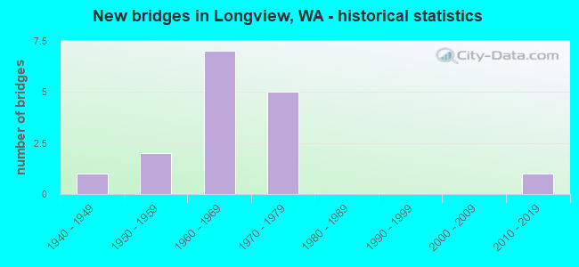
- New bridges - historical statistics
- 11940-1949
- 21950-1959
- 71960-1969
- 51970-1979
- 12010-2019


- Bridge Condition - Deck
- 15.4%Very good
- 61.5%Good
- 23.1%Satisfactory

- Bridge Condition - Superstructure
- 15.4%Very good
- 53.8%Good
- 30.8%Satisfactory

- Bridge Condition - Substructure
- 15.4%Very good
- 38.5%Good
- 46.2%Satisfactory

- Bridge Condition - Channel
- 41.7%Very good
- 50.0%Good
- 8.3%Satisfactory
Find on map >> Show street view
Structure Number: 6321A, Location: 2.0 E JCT SR 411 (Lat: 46.106914, Lng: -122.894419), Route carried "on" structure: State highway 432, Year Built: 1961, Year Reconstructed: 1971, Status: Open, Structure Length: 51.08m (167.59ft), Average Daily Traffic: 17,791 (year 2019), Truck Traffic: 3%, Average Future Daily Traffic: 23,768 (year 2039), Design Load: HS 20+Mod, Features Intersected: COWLITZ R & NP RY
Minimum Vertical Clearance: 5.11m (16.77ft), Kilometerpoint: 15.418, Lanes on structure: 2, Lanes under structure: 4, Base Highway Network: Yes, Owner: State Highway Agency, Approaching Roadway Width: 11.0m (36.1ft), Navigation Control: Yes ( Vertical Clearance: 12.8m (42.0ft), Horizontal Clearance: 85.3m (279.9ft)), Material/Design: Steel, Design/Construction: Truss - Thru, Number Of Spans In Main Unit: 1, Number Of Approach Spans: 12, Length of Maximum Span: 91.4m (299.9ft), Curb-To-Curb Width: 9.0m (29.5ft), Out-to-Out Width: 9.8m (32.2ft)
Condition: Deck: Satisfactory, Superstructure: Satisfactory, Substructure: Satisfactory, Channel: Good, Operating Rating: 61.7 metric tons, Method Used To Determine Operating Rating: Load Factor (LF), Inventory Rating: 37.2 metric tons, Method Used To Determine Inventory Rating: Load Factor (LF), Structural Evaluation: Equal to present minimum criteria, Deck Geometry: Meets minimum limits, Underclear: Meets minimum limits, Waterway Adequacy: Equal to present desirable criteria, Approach Roadway Alignment: Equal to present desirable criteria, Length Of Structure Improvement: 51.08m (167.59ft), Designated Inspection Frequency: Every 24 months, Critical Feature Inspection Frequency: Every 24 months, Underwater Inspection Frequency: Every 60 months, Inspection Date: April 2021, Critical Feature Inspection Date: April 2021, Underwater Inspection Date: September 2020, Bridge Improvement Cost: $12,738,000, Roadway Improvement Cost: $2,548,000, Total Project Cost: $25,475,000 ( Estimate for 2014), Deck Structure Type: Concrete Cast-file-Place, Wearing Surface/Protective System: Wearing Surface: Monolithic Concrete
Find on map >> Show street view
Structure Number: 6697A, Location: 1.5 E JCT SR 433 (Lat: 46.123044, Lng: -122.926578), Route carried "on" structure: State highway 432, Year Built: 1961, Status: Open, Structure Length: 9.11m (29.89ft), Average Daily Traffic: 8,283 (year 2019), Truck Traffic: 3%, Average Future Daily Traffic: 11,066 (year 2039), Design Load: HS 20, Features Intersected: 3RD AVE / SR 411
Minimum Vertical Clearance: 30+ m (98+ ft), Kilometerpoint: 12.295, Lanes on structure: 3, Lanes under structure: 4, Base Highway Network: Yes, Owner: State Highway Agency, Approaching Roadway Width: 13.4m (44.0ft), Material/Design: Concrete continuous, Design/Construction: Box Beam or Girders - Multiple, Number Of Spans In Main Unit: 5, Length of Maximum Span: 31.1m (102.0ft), Curb-To-Curb Width: 13.6m (44.6ft), Out-to-Out Width: 14.6m (47.9ft)
Condition: Deck: Good, Superstructure: Good, Substructure: Good, Operating Rating: 30.1 metric tons, Method Used To Determine Operating Rating: Load and Resistance Factor Rating (LRFR) rating reported by rating factor(RF) method using HL-93 loadings, Inventory Rating: 23.3 metric tons, Method Used To Determine Inventory Rating: Load and Resistance Factor Rating (LRFR) rating reported by rating factor(RF) method using HL-93 loadings, Structural Evaluation: Somewhat better than minimum adequacy, Deck Geometry: Meets minimum limits, Underclear: High priority of corrective action, Approach Roadway Alignment: Equal to present desirable criteria, Length Of Structure Improvement: 9.11m (29.89ft), Designated Inspection Frequency: Every 48 months, Inspection Date: April 2018, Bridge Improvement Cost: $2,751,000, Roadway Improvement Cost: $550,000, Total Project Cost: $5,502,000 ( Estimate for 2014), Deck Structure Type: Concrete Cast-file-Place, Wearing Surface/Protective System: Wearing Surface: Latex Concrete
Find on map >> Show street view
Structure Number: 7399A, Location: 9.3 E WAHKIAKUM CO (Lat: 46.178139, Lng: -123.030833), Route carried "on" structure: State highway 4, Year Built: 1964, Status: Open, Structure Length: 5.43m (17.81ft), Average Daily Traffic: 5,545 (year 2019), Truck Traffic: 9%, Average Future Daily Traffic: 7,408 (year 2039), Design Load: HS 20, Features Intersected: COAL CR SL
Minimum Vertical Clearance: 30+ m (98+ ft), Kilometerpoint: 88.482, Lanes on structure: 2, Base Highway Network: Yes, Owner: State Highway Agency, Approaching Roadway Width: 8.5m (27.9ft), Material/Design: Prestressed concrete, Design/Construction: Stringer/Multi-beam, Number Of Spans In Main Unit: 4, Length of Maximum Span: 16.5m (54.1ft), Curb-To-Curb Width: 8.5m (27.9ft), Out-to-Out Width: 10.2m (33.5ft)
Condition: Deck: Good, Superstructure: Good, Substructure: Good, Channel: Satisfactory, Operating Rating: 25.3 metric tons, Method Used To Determine Operating Rating: Load and Resistance Factor Rating (LRFR) rating reported by rating factor(RF) method using HL-93 loadings, Inventory Rating: 19.4 metric tons, Method Used To Determine Inventory Rating: Load and Resistance Factor Rating (LRFR) rating reported by rating factor(RF) method using HL-93 loadings, Structural Evaluation: Meets minimum limits, Deck Geometry: High priority of replacement, Waterway Adequacy: Equal to present desirable criteria, Approach Roadway Alignment: Equal to present desirable criteria, Length Of Structure Improvement: 5.43m (17.81ft), Designated Inspection Frequency: Every 24 months, Underwater Inspection Frequency: Every 60 months, Inspection Date: October 2021, Underwater Inspection Date: July 2021, Bridge Improvement Cost: $1,068,000, Roadway Improvement Cost: $214,000, Total Project Cost: $2,136,000 ( Estimate for 2014), Deck Structure Type: Concrete Cast-file-Place, Wearing Surface/Protective System: Wearing Surface: Latex Concrete
Find on map >> Show street view
Structure Number: 9100A, Location: 2.0 E JCT SR 411 (Lat: 46.107106, Lng: -122.894400), Route carried "on" structure: State highway 432, Year Built: 1973, Status: Open, Structure Length: 52.70m (172.90ft), Average Daily Traffic: 17,791 (year 2019), Truck Traffic: 3%, Average Future Daily Traffic: 23,768 (year 2039), Design Load: HS 20+Mod, Features Intersected: COWLITZ RIVER & BNSF
Minimum Vertical Clearance: 5.89m (19.32ft), Kilometerpoint: 15.418, Lanes on structure: 2, Lanes under structure: 4, Base Highway Network: Yes, Owner: State Highway Agency, Approaching Roadway Width: 15.2m (49.9ft), Navigation Control: Yes ( Vertical Clearance: 19.2m (63.0ft), Horizontal Clearance: 85.3m (279.9ft)), Material/Design: Steel, Design/Construction: Truss - Thru, Number Of Spans In Main Unit: 1, Number Of Approach Spans: 12, Length of Maximum Span: 91.4m (299.9ft), Curb or Sidewalk Widths: Left: 0.2m (0.7ft), Right: 0.2m (0.7ft), Curb-To-Curb Width: 11.6m (38.1ft), Out-to-Out Width: 12.5m (41.0ft)
Condition: Deck: Satisfactory, Superstructure: Satisfactory, Substructure: Satisfactory, Channel: Good, Operating Rating: 57.1 metric tons, Method Used To Determine Operating Rating: Load Factor (LF), Inventory Rating: 34.5 metric tons, Method Used To Determine Inventory Rating: Load Factor (LF), Structural Evaluation: Equal to present minimum criteria, Deck Geometry: Equal to present minimum criteria, Underclear: High priority of corrective action, Waterway Adequacy: Equal to present desirable criteria, Approach Roadway Alignment: Equal to present desirable criteria, Length Of Structure Improvement: 52.70m (172.90ft), Designated Inspection Frequency: Every 24 months, Critical Feature Inspection Frequency: Every 24 months, Underwater Inspection Frequency: Every 60 months, Inspection Date: April 2021, Critical Feature Inspection Date: April 2021, Underwater Inspection Date: September 2020, Bridge Improvement Cost: $17,982,000, Roadway Improvement Cost: $3,596,000, Total Project Cost: $35,963,000 ( Estimate for 2014), Deck Structure Type: Concrete Cast-file-Place, Wearing Surface/Protective System: Wearing Surface: Monolithic Concrete
Find on map >> Show street view
Structure Number: 9874A, Location: 1.5 E JCT SR 433 (Lat: 46.123222, Lng: -122.926667), Route carried "on" structure: State highway 432, Year Built: 1975, Status: Open, Structure Length: 8.47m (27.79ft), Average Daily Traffic: 8,283 (year 2019), Truck Traffic: 3%, Average Future Daily Traffic: 11,066 (year 2039), Design Load: HS 20+Mod, Features Intersected: SR 411/3RD AVE
Minimum Vertical Clearance: 30+ m (98+ ft), Kilometerpoint: 12.295, Lanes on structure: 2, Lanes under structure: 4, Base Highway Network: Yes, Owner: State Highway Agency, Approaching Roadway Width: 12.2m (40.0ft), Material/Design: Prestressed concrete, Design/Construction: Stringer/Multi-beam, Number Of Spans In Main Unit: 1, Number Of Approach Spans: 2, Length of Maximum Span: 33.5m (109.9ft), Curb-To-Curb Width: 12.2m (40.0ft), Out-to-Out Width: 13.6m (44.6ft)
Condition: Deck: Good, Superstructure: Satisfactory, Substructure: Good, Operating Rating: 48.1 metric tons, Method Used To Determine Operating Rating: Load Factor (LF), Inventory Rating: 28.1 metric tons, Method Used To Determine Inventory Rating: Load Factor (LF), Structural Evaluation: Equal to present minimum criteria, Deck Geometry: Better than present minimum criteria, Underclear: Better than present minimum criteria, Approach Roadway Alignment: Equal to present desirable criteria, Length Of Structure Improvement: 8.47m (27.79ft), Designated Inspection Frequency: Every 24 months, Inspection Date: May 2021, Bridge Improvement Cost: $2,335,000, Roadway Improvement Cost: $467,000, Total Project Cost: $4,670,000 ( Estimate for 2014), Deck Structure Type: Concrete Cast-file-Place, Wearing Surface/Protective System: Wearing Surface: Monolithic Concrete
Find on map >> Show street view
Structure Number: 200111, Location: 2.8 E JCT SR 4 (Lat: 46.146983, Lng: -123.002900), Route carried "on" structure: State highway 432, Year Built: 1961, Status: Open, Structure Length: 0.70m (2.30ft), Average Daily Traffic: 6,332 (year 2019), Truck Traffic: 10%, Average Future Daily Traffic: 8,459 (year 2039), Design Load: HS 20, Features Intersected: SOLO SLOUGH
Minimum Vertical Clearance: 30+ m (98+ ft), Kilometerpoint: 4.490, Lanes on structure: 2, Base Highway Network: Yes, Owner: State Highway Agency, Approaching Roadway Width: 9.8m (32.2ft), Skew: 7 degrees, Material/Design: Steel, Design/Construction: Culvert, Number Of Spans In Main Unit: 1, Length of Maximum Span: 7.0m (23.0ft)
Condition: Channel: Very good, Culverts: Good, Operating Rating: 89.8 metric tons, Method Used To Determine Operating Rating: Load Factor (LF), Inventory Rating: 89.8 metric tons, Method Used To Determine Inventory Rating: Load Factor (LF), Structural Evaluation: Better than present minimum criteria, Waterway Adequacy: Equal to present desirable criteria, Approach Roadway Alignment: Equal to present desirable criteria, Length Of Structure Improvement: 0.70m (2.30ft), Designated Inspection Frequency: Every 48 months, Inspection Date: September 2018, Bridge Improvement Cost: $156,000, Roadway Improvement Cost: $31,000, Total Project Cost: $313,000 ( Estimate for 2014)
Find on map >> Show street view
Structure Number: 81066, Location: 0.35 NW COAL CRK RD (0.54 (Lat: 46.186667, Lng: -123.036111), Route carried "on" structure: County highway 21810, Year Built: 1953, Status: Open, Structure Length: 1.74m (5.71ft), Average Daily Traffic: 2,253 (year 2019), Truck Traffic: 2%, Average Future Daily Traffic: 3,180 (year 2039), Design Load: HS 25 or greater, Features Intersected: COAL CREEK, Facility Carried by Structure: HARMONY DR
Minimum Vertical Clearance: 30+ m (98+ ft), Kilometerpoint: 0.001, Lanes on structure: 2, Owner: County Highway Agency, Approaching Roadway Width: 7.3m (24.0ft), Material/Design: Concrete continuous, Design/Construction: Slab, Number Of Spans In Main Unit: 2, Length of Maximum Span: 7.9m (25.9ft), Curb or Sidewalk Widths: Left: 0.5m (1.6ft), Right: 0.5m (1.6ft), Curb-To-Curb Width: 6.7m (22.0ft), Out-to-Out Width: 7.8m (25.6ft)
Condition: Deck: Good, Superstructure: Good, Substructure: Satisfactory, Channel: Good, Operating Rating: 84.4 metric tons, Method Used To Determine Operating Rating: Load Factor (LF), Inventory Rating: 50.8 metric tons, Method Used To Determine Inventory Rating: Load Factor (LF), Structural Evaluation: Equal to present minimum criteria, Deck Geometry: High priority of replacement, Waterway Adequacy: Equal to present desirable criteria, Approach Roadway Alignment: Equal to present desirable criteria, Length Of Structure Improvement: 2.04m (6.69ft), Designated Inspection Frequency: Every 24 months, Inspection Date: September 2021, Bridge Improvement Cost: $1,018,000, Roadway Improvement Cost: $204,000, Total Project Cost: $2,037,000 ( Estimate for 2014), Deck Structure Type: Concrete Cast-file-Place
Find on map >> Show street view
Structure Number: 83587, Location: 0.06 N COAL CRK RD (2.47) (Lat: 46.206111, Lng: -123.019444), Route carried "on" structure: County highway 22570, Year Built: 1976, Status: Open, Structure Length: 3.51m (11.52ft), Average Daily Traffic: 257 (year 2017), Truck Traffic: 7%, Average Future Daily Traffic: 550 (year 2039), Design Load: HS 20, Features Intersected: COAL CREEK, Facility Carried by Structure: CARLON LOOP RD
Minimum Vertical Clearance: 30+ m (98+ ft), Kilometerpoint: 0.001, Lanes on structure: 2, Owner: County Highway Agency, Approaching Roadway Width: 7.9m (25.9ft), Material/Design: Prestressed concrete, Design/Construction: Stringer/Multi-beam, Number Of Spans In Main Unit: 1, Length of Maximum Span: 33.8m (110.9ft), Curb-To-Curb Width: 8.5m (27.9ft), Out-to-Out Width: 9.4m (30.8ft)
Condition: Deck: Good, Superstructure: Good, Substructure: Good, Channel: Very good, Operating Rating: 37.2 metric tons, Method Used To Determine Operating Rating: Load Factor (LF), Inventory Rating: 21.8 metric tons, Method Used To Determine Inventory Rating: Load Factor (LF), Structural Evaluation: Equal to present minimum criteria, Deck Geometry: Equal to present minimum criteria, Waterway Adequacy: Equal to present desirable criteria, Approach Roadway Alignment: High priority of corrective action, Length Of Structure Improvement: 3.81m (12.50ft), Designated Inspection Frequency: Every 24 months, Inspection Date: March 2021, Bridge Improvement Cost: $1,900,000, Roadway Improvement Cost: $380,000, Total Project Cost: $3,800,000 ( Estimate for 2014), Deck Structure Type: Concrete Cast-file-Place
Find on map >> Show street view
Structure Number: 83602, Location: 0.30 N COAL CRK RD (5.04) (Lat: 46.238056, Lng: -123.043889), Route carried "on" structure: County highway 22830, Year Built: 1975, Status: Open, Structure Length: 0.88m (2.89ft), Average Daily Traffic: 38 (year 2019), Truck Traffic: 5%, Average Future Daily Traffic: 55 (year 2039), Design Load: HS 20, Features Intersected: COAL CREEK EAST FORK, Facility Carried by Structure: HACKETT RD
Minimum Vertical Clearance: 30+ m (98+ ft), Kilometerpoint: 0.001, Lanes on structure: 2, Owner: County Highway Agency, Approaching Roadway Width: 8.5m (27.9ft), Skew: 2 degrees, Material/Design: Prestressed concrete, Design/Construction: Stringer/Multi-beam, Number Of Spans In Main Unit: 1, Length of Maximum Span: 8.2m (26.9ft), Curb-To-Curb Width: 8.5m (27.9ft), Out-to-Out Width: 9.3m (30.5ft)
Condition: Deck: Satisfactory, Superstructure: Good, Substructure: Satisfactory, Channel: Good, Operating Rating: 54.4 metric tons, Method Used To Determine Operating Rating: Load Factor (LF), Inventory Rating: 32.7 metric tons, Method Used To Determine Inventory Rating: Load Factor (LF), Structural Evaluation: Equal to present minimum criteria, Deck Geometry: Better than present minimum criteria, Waterway Adequacy: Equal to present desirable criteria, Approach Roadway Alignment: Equal to present minimum criteria, Length Of Structure Improvement: 1.19m (3.90ft), Designated Inspection Frequency: Every 24 months, Inspection Date: September 2021, Bridge Improvement Cost: $593,000, Roadway Improvement Cost: $119,000, Total Project Cost: $1,186,000 ( Estimate for 2014), Deck Structure Type: Concrete Cast-file-Place
Find on map >> Show street view
Structure Number: 83632, Location: 0.07 S COAL CRK RD (3.62) (Lat: 46.220833, Lng: -123.021389), Route carried "on" structure: County highway 22570, Year Built: 1963, Status: Open, Structure Length: 2.50m (8.20ft), Average Daily Traffic: 88 (year 2019), Truck Traffic: 8%, Average Future Daily Traffic: 125 (year 2039), Design Load: HS 15, Features Intersected: COAL CREEK, Facility Carried by Structure: CARLON LOOP RD
Minimum Vertical Clearance: 30+ m (98+ ft), Kilometerpoint: 0.001, Lanes on structure: 2, Owner: County Highway Agency, Approaching Roadway Width: 6.4m (21.0ft), Skew: 1 degrees, Material/Design: Steel, Design/Construction: Stringer/Multi-beam, Number Of Spans In Main Unit: 2, Length of Maximum Span: 12.2m (40.0ft), Curb or Sidewalk Widths: Left: 0.1m (0.3ft), Right: 0.1m (0.3ft), Curb-To-Curb Width: 7.9m (25.9ft), Out-to-Out Width: 8.8m (28.9ft)
Condition: Deck: Good, Superstructure: Good, Substructure: Satisfactory, Channel: Good, Operating Rating: 31.7 metric tons, Method Used To Determine Operating Rating: Load Factor (LF), Inventory Rating: 19.0 metric tons, Method Used To Determine Inventory Rating: Load Factor (LF), Structural Evaluation: Somewhat better than minimum adequacy, Deck Geometry: Equal to present minimum criteria, Waterway Adequacy: Equal to present desirable criteria, Approach Roadway Alignment: High priority of corrective action, Length Of Structure Improvement: 2.80m (9.19ft), Designated Inspection Frequency: Every 24 months, Inspection Date: September 2021, Bridge Improvement Cost: $1,398,000, Roadway Improvement Cost: $280,000, Total Project Cost: $2,797,000 ( Estimate for 2014), Deck Structure Type: Concrete Cast-file-Place
Find on map >> Show street view
Structure Number: 8543, Location: 0.32 NE SR 4 (MP 56.75) (Lat: 46.167833, Lng: -122.996361), Route carried "on" structure: City street 6751, Year Built: 1955, Status: Open, Structure Length: 1.98m (6.50ft), Average Daily Traffic: 2,750 (year 2018), Truck Traffic: 8%, Average Future Daily Traffic: 3,700 (year 2038), Design Load: H 15, Features Intersected: CUTOFF SLOUGH, Facility Carried by Structure: 46TH AVE
Minimum Vertical Clearance: 30+ m (98+ ft), Kilometerpoint: 0.001, Lanes on structure: 2, Owner: City or Municipal Highway Agency, Approaching Roadway Width: 6.7m (22.0ft), Material/Design: Concrete continuous, Design/Construction: Slab, Number Of Spans In Main Unit: 3, Length of Maximum Span: 6.7m (22.0ft), Curb or Sidewalk Widths: Left: 0.6m (2.0ft), Right: 0.6m (2.0ft), Curb-To-Curb Width: 7.9m (25.9ft), Out-to-Out Width: 9.4m (30.8ft)
Condition: Deck: Good, Superstructure: Good, Substructure: Good, Channel: Good, Operating Rating: 47.2 metric tons, Method Used To Determine Operating Rating: Load Factor (LF), Inventory Rating: 28.1 metric tons, Method Used To Determine Inventory Rating: Load Factor (LF), Structural Evaluation: Better than present minimum criteria, Deck Geometry: High priority of corrective action, Waterway Adequacy: Equal to present desirable criteria, Approach Roadway Alignment: Equal to present desirable criteria, Length Of Structure Improvement: 2.29m (7.51ft), Designated Inspection Frequency: Every 24 months, Inspection Date: Febuary 2021, Bridge Improvement Cost: $1,140,000, Roadway Improvement Cost: $228,000, Total Project Cost: $2,280,000 ( Estimate for 2014), Deck Structure Type: Concrete Cast-file-Place
Find on map >> Show street view
Structure Number: 85506, Location: LOUISIANA ST. & LAKE SAC. (Lat: 46.142500, Lng: -122.952028), Route carried "on" structure: City street 65, Year Built: 1967, Status: Open, Structure Length: 2.44m (8.01ft), Average Daily Traffic: 8,100 (year 2021), Truck Traffic: 5%, Average Future Daily Traffic: 10,900 (year 2041), Design Load: HS 20, Features Intersected: LAKE SACAJAWEA, Facility Carried by Structure: LOUISIANA ST
Minimum Vertical Clearance: 30+ m (98+ ft), Kilometerpoint: 0.001, Lanes on structure: 2, Owner: City or Municipal Highway Agency, Approaching Roadway Width: 11.0m (36.1ft), Material/Design: Prestressed concrete, Design/Construction: Stringer/Multi-beam, Number Of Spans In Main Unit: 1, Length of Maximum Span: 24.4m (80.1ft), Curb or Sidewalk Widths: Left: 1.5m (4.9ft), Right: 1.5m (4.9ft), Curb-To-Curb Width: 11.0m (36.1ft), Out-to-Out Width: 14.8m (48.6ft)
Condition: Deck: Very good, Superstructure: Very good, Substructure: Very good, Channel: Very good, Operating Rating: 61.7 metric tons, Method Used To Determine Operating Rating: Load and Resistance Factor (LRFR), Inventory Rating: 36.3 metric tons, Method Used To Determine Inventory Rating: Load and Resistance Factor (LRFR), Structural Evaluation: Equal to present desirable criteria, Deck Geometry: Meets minimum limits, Waterway Adequacy: Equal to present desirable criteria, Approach Roadway Alignment: Equal to present desirable criteria, Length Of Structure Improvement: 2.44m (8.01ft), Designated Inspection Frequency: Every 24 months, Inspection Date: Febuary 2021, Bridge Improvement Cost: $608,000, Roadway Improvement Cost: $122,000, Total Project Cost: $1,216,000 ( Estimate for 2014), Deck Structure Type: Concrete Cast-file-Place
Find on map >> Show street view
Structure Number: 85584, Location: JCT 20th AVE. & LAKE SACA (Lat: 46.130250, Lng: -122.947000), Route carried "on" structure: City street 20, Year Built: 1940, Status: Posted for load, Structure Length: 4.97m (16.31ft), Average Daily Traffic: 3,133 (year 2019), Truck Traffic: 5%, Average Future Daily Traffic: 3,846 (year 2032), Design Load: H 15, Features Intersected: LAKE SACAJAWEA
Minimum Vertical Clearance: 30+ m (98+ ft), Kilometerpoint: 0.001, Lanes on structure: 2, Owner: City or Municipal Highway Agency, Approaching Roadway Width: 11.0m (36.1ft), Material/Design: Wood or Timber, Design/Construction: Stringer/Multi-beam, Number Of Spans In Main Unit: 9, Length of Maximum Span: 9.8m (32.2ft), Curb or Sidewalk Widths: Left: 1.8m (5.9ft), Right: 1.5m (4.9ft), Curb-To-Curb Width: 7.3m (24.0ft), Out-to-Out Width: 11.0m (36.1ft)
Condition: Deck: Good, Superstructure: Satisfactory, Substructure: Satisfactory, Channel: Very good, Operating Rating: 35.4 metric tons, Method Used To Determine Operating Rating: Allowable Stress (AS), Inventory Rating: 23.6 metric tons, Method Used To Determine Inventory Rating: Allowable Stress (AS), Structural Evaluation: Equal to present minimum criteria, Deck Geometry: High priority of replacement, Waterway Adequacy: Equal to present desirable criteria, Approach Roadway Alignment: Equal to present desirable criteria, Bridge Posting: Required (Relationship of Operating Rating to Maximum Legal Load: 0.1 - 9.9% below), Length Of Structure Improvement: 5.27m (17.29ft), Designated Inspection Frequency: Every 24 months, Underwater Inspection Frequency: Every 60 months, Inspection Date: March 2021, Underwater Inspection Date: March 2017, Bridge Improvement Cost: $2,630,000, Roadway Improvement Cost: $526,000, Total Project Cost: $5,259,000 ( Estimate for 2014), Deck Structure Type: Wood or Timber, Wearing Surface/Protective System: Wearing Surface: Bituminous
Find on map >> Show street view
Structure Number: 88791, Location: BETWEEN NICHOLS & KESSLER (Lat: 46.133889, Lng: -122.951944), Route carried "on" structure: City street 62, Year Built: 2015, Status: Open, Structure Length: 4.39m (14.40ft), Average Daily Traffic: 9,950 (year 2013), Truck Traffic: 5%, Average Future Daily Traffic: 18,000 (year 2035), Design Load: HL 93, Features Intersected: LAKE SACAJAWEA, Facility Carried by Structure: WASHINGTON WAY
Minimum Vertical Clearance: 30+ m (98+ ft), Kilometerpoint: 0.001, Lanes on structure: 5, Base Highway Network: Yes, Owner: City or Municipal Highway Agency, Approaching Roadway Width: 17.4m (57.1ft), Material/Design: Prestressed concrete continuous, Design/Construction: Slab, Number Of Spans In Main Unit: 3, Length of Maximum Span: 18.3m (60.0ft), Curb or Sidewalk Widths: Left: 2.1m (6.9ft), Right: 2.1m (6.9ft), Curb-To-Curb Width: 17.4m (57.1ft), Out-to-Out Width: 22.3m (73.2ft)
Condition: Deck: Very good, Superstructure: Very good, Substructure: Very good, Channel: Very good, Operating Rating: 46.3 metric tons, Method Used To Determine Operating Rating: Load and Resistance Factor Rating (LRFR) rating reported by rating factor(RF) method using HL-93 loadings, Inventory Rating: 35.6 metric tons, Method Used To Determine Inventory Rating: Load and Resistance Factor Rating (LRFR) rating reported by rating factor(RF) method using HL-93 loadings, Structural Evaluation: Equal to present desirable criteria, Deck Geometry: High priority of replacement, Waterway Adequacy: Equal to present desirable criteria, Approach Roadway Alignment: Equal to present desirable criteria, Length Of Structure Improvement: 4.69m (15.39ft), Designated Inspection Frequency: Every 48 months, Underwater Inspection Frequency: Every 60 months, Inspection Date: March 2019, Underwater Inspection Date: March 2017, Bridge Improvement Cost: $5,413,000, Roadway Improvement Cost: $1,083,000, Total Project Cost: $10,826,000 ( Estimate for 2022), Deck Structure Type: Concrete Cast-file-Place, Wearing Surface/Protective System: Deck Protection: Epoxy Coated Reinforcing
Find on map >> Show street view
Structure Number: 6697A, Location: JCT SR 432 (Lat: 46.123044, Lng: -122.926578), Route carried "under" structure: State highway 411, Year Built: 1961, Structure Length: 0. m, Average Daily Traffic: 17,753 (year 2019), Truck Traffic: 15%, Features Intersected: 3RD AVE / SR 411, Facility Carried by Structure: SR 432
Minimum Vertical Clearance: 7.29m (23.92ft), Kilometerpoint: 12.247, Lanes on structure: 3, Lanes under structure: 4, Material/Design: Concrete continuous, Design/Construction: Box Beam or Girders - Multiple, Length of Maximum Span: 31.1m (102.0ft)
Find on map >> Show street view
Structure Number: 9874A, Location: JCT SR 432 (Lat: 46.123222, Lng: -122.926667), Route carried "under" structure: State highway 411, Year Built: 1975, Structure Length: 0. m, Average Daily Traffic: 17,753 (year 2019), Truck Traffic: 15%, Features Intersected: SR 411/3RD AVE, Facility Carried by Structure: SR 432
Minimum Vertical Clearance: 7.59m (24.90ft), Kilometerpoint: 0.001, Lanes on structure: 2, Lanes under structure: 4, Material/Design: Prestressed concrete, Design/Construction: Stringer/Multi-beam, Length of Maximum Span: 33.5m (109.9ft)