Bridge Statistics for Littleton, Massachusetts (MA)
Condition, Traffic, Stress, Structural Evaluation, Project Costs
- National Bridge Inventory (NBI) Statistics
- 33Number of bridges
- 341ft / 104mTotal length
- $56,152,000Total costs
- 1,171,360Total average daily traffic
- 72,788Total average daily truck traffic
- National Bridge Inventory (NBI) Registered Bridges for Littleton
- No street view available for this location
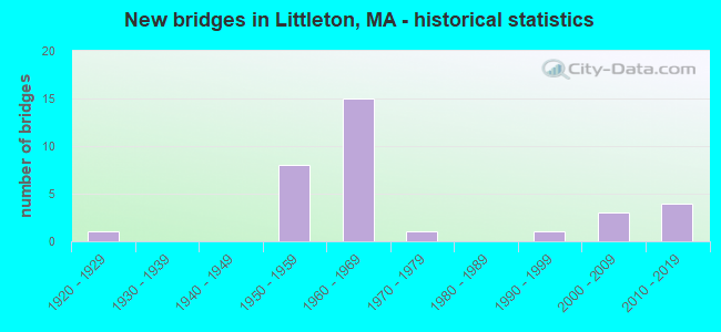
- New bridges - historical statistics
- 11920-1929
- 81950-1959
- 151960-1969
- 11970-1979
- 11990-1999
- 32000-2009
- 42010-2019

- Reconstructed bridges - Historical Statistics
- 11970-1979
- 01980-1989
- 21990-1999
- 12000-2009
- 22010-2019


- Bridge Condition - Deck
- 20.0%Very good
- 40.0%Good
- 30.0%Satisfactory
- 5.0%Fair
- 5.0%Poor

- Bridge Condition - Superstructure
- 35.0%Very good
- 15.0%Good
- 45.0%Satisfactory
- 5.0%Fair

- Bridge Condition - Substructure
- 20.0%Very good
- 35.0%Good
- 20.0%Satisfactory
- 25.0%Fair

- Bridge Condition - Channel
- 42.9%Good
- 42.9%Satisfactory
- 14.3%Fair

- Bridge Condition - Culverts
- 33.3%Good
- 66.7%Satisfactory
Find on map >> Show street view
Structure Number: B05002AYTMUNNBI, Location: 200' W INT S. MAIN ST (Lat: 42.210783, Lng: -72.346569), Route carried "on" structure: City street , Year Built: 2005, Status: Open, Structure Length: 2.85m (9.35ft), Average Daily Traffic: 4,784 (year 2019), Truck Traffic: 5%, Average Future Daily Traffic: 6,791 (year 2032), Design Load: HS 25 or greater, Features Intersected: WATER SWIFT RIVER, Facility Carried by Structure: HWY RIVER ST
Minimum Vertical Clearance: 30+ m (98+ ft), Kilometerpoint: 0.016, Lanes on structure: 2, Owner: Town or Township Highway Agency, Approaching Roadway Width: 7.5m (24.6ft), Skew: 1 degrees, Material/Design: Prestressed concrete, Design/Construction: Box Beam or Girders - Single/Spread, Number Of Spans In Main Unit: 1, Length of Maximum Span: 27.5m (90.2ft), Curb or Sidewalk Widths: Left: 0.0m, Right: 1.8m (5.9ft), Curb-To-Curb Width: 7.5m (24.6ft), Out-to-Out Width: 10.2m (33.5ft)
Condition: Deck: Good, Superstructure: Very good, Substructure: Very good, Channel: Good, Operating Rating: 82.9 metric tons, Method Used To Determine Operating Rating: Load Factor (LF), Inventory Rating: 49.7 metric tons, Method Used To Determine Inventory Rating: Load Factor (LF), Structural Evaluation: Equal to present desirable criteria, Deck Geometry: High priority of replacement, Waterway Adequacy: Better than present minimum criteria, Approach Roadway Alignment: Equal to present minimum criteria, Length Of Structure Improvement: 2.90m (9.51ft), Designated Inspection Frequency: Every 24 months, Inspection Date: November 2021, Bridge Improvement Cost: $1,614,000, Roadway Improvement Cost: $162,000, Total Project Cost: $2,422,000 ( Estimate for 2022), Deck Structure Type: Concrete Cast-file-Place, Wearing Surface/Protective System: Wearing Surface: Integral Concrete, Deck Protection: Epoxy Coated Reinforcing
Find on map >> Show street view
Structure Number: B0502790DDOTNBI, Location: .3 M W JCT RIVER RD (Lat: 42.273814, Lng: -72.337625), Route carried "on" structure: State highway 9, Year Built: 2007, Status: Open, Structure Length: 3.22m (10.56ft), Average Daily Traffic: 6,315 (year 2018), Truck Traffic: 8%, Average Future Daily Traffic: 15,161 (year 2032), Design Load: HS 25 or greater, Features Intersected: WATER SWIFT RIVER
Minimum Vertical Clearance: 30+ m (98+ ft), Kilometerpoint: 4.667, Lanes on structure: 2, Base Highway Network: Yes, Owner: State Highway Agency, Approaching Roadway Width: 12.5m (41.0ft), Material/Design: Prestressed concrete, Design/Construction: Stringer/Multi-beam, Number Of Spans In Main Unit: 1, Length of Maximum Span: 31.0m (101.7ft), Curb-To-Curb Width: 12.5m (41.0ft), Out-to-Out Width: 13.5m (44.3ft)
Condition: Deck: Good, Superstructure: Good, Substructure: Good, Channel: Good, Operating Rating: 85.1 metric tons, Method Used To Determine Operating Rating: Load Factor (LF), Inventory Rating: 51.0 metric tons, Method Used To Determine Inventory Rating: Load Factor (LF), Structural Evaluation: Better than present minimum criteria, Deck Geometry: Somewhat better than minimum adequacy, Waterway Adequacy: Equal to present desirable criteria, Approach Roadway Alignment: Equal to present desirable criteria, Length Of Structure Improvement: 3.30m (10.83ft), Designated Inspection Frequency: Every 24 months, Inspection Date: July 2021, Bridge Improvement Cost: $281,000, Roadway Improvement Cost: $29,000, Total Project Cost: $422,000 ( Estimate for 2022), Deck Structure Type: Concrete Cast-file-Place, Wearing Surface/Protective System: Wearing Surface: Bituminous, Membrane: Preformed Fabric, Deck Protection: Epoxy Coated Reinforcing
Find on map >> Show street view
Structure Number: L13001AMDDOT634, Location: .2 MI S OF GROTON T.L. (Lat: 42.567669, Lng: -71.509217), Route carried "on" structure: State highway 119, Year Built: 1995, Status: Open, Structure Length: 4.52m (14.83ft), Average Daily Traffic: 12,171 (year 2020), Truck Traffic: 10%, Average Future Daily Traffic: 26,848 (year 2032), Design Load: HS 20, Features Intersected: RR BMRR
Minimum Vertical Clearance: 30+ m (98+ ft), Kilometerpoint: 42.131, Lanes on structure: 2, Owner: State Highway Agency, Approaching Roadway Width: 13.4m (44.0ft), Skew: 1 degrees, Material/Design: Prestressed concrete continuous, Design/Construction: Box Beam or Girders - Multiple, Number Of Spans In Main Unit: 3, Length of Maximum Span: 14.9m (48.9ft), Curb or Sidewalk Widths: Left: 0.0m, Right: 1.5m (4.9ft), Curb-To-Curb Width: 13.4m (44.0ft), Out-to-Out Width: 16.0m (52.5ft)
Condition: Deck: Satisfactory, Superstructure: Satisfactory, Substructure: Good, Operating Rating: 71.4 metric tons, Method Used To Determine Operating Rating: Load Factor (LF), Inventory Rating: 42.8 metric tons, Method Used To Determine Inventory Rating: Load Factor (LF), Structural Evaluation: Equal to present minimum criteria, Deck Geometry: Equal to present minimum criteria, Underclear: Somewhat better than minimum adequacy, Approach Roadway Alignment: Somewhat better than minimum adequacy, Length Of Structure Improvement: 4.60m (15.09ft), Designated Inspection Frequency: Every 24 months, Inspection Date: July 2021, Bridge Improvement Cost: $579,000, Roadway Improvement Cost: $58,000, Total Project Cost: $869,000 ( Estimate for 2022), Deck Structure Type: Concrete Precast Panels, Wearing Surface/Protective System: Wearing Surface: Bituminous, Membrane: Built-up, Deck Protection: Epoxy Coated Reinforcing
Find on map >> Show street view
Structure Number: L1300826WDOTNBI, Location: 0.2 MI. WEST OF I 495 (Lat: 42.567653, Lng: -71.509206), Route carried "on" structure: State highway 119, Year Built: 1921, Status: Posted for load, Structure Length: 0.79m (2.59ft), Average Daily Traffic: 23,800 (year 2018), Truck Traffic: 10%, Average Future Daily Traffic: 37,587 (year 2033), Design Load: H 15, Features Intersected: WATER BEAVER BROOK
Minimum Vertical Clearance: 30+ m (98+ ft), Kilometerpoint: 44.384, Lanes on structure: 2, Base Highway Network: Yes, Owner: State Highway Agency, Approaching Roadway Width: 7.3m (24.0ft), Material/Design: Concrete, Design/Construction: Tee Beam, Number Of Spans In Main Unit: 1, Length of Maximum Span: 7.3m (24.0ft), Curb or Sidewalk Widths: Left: 0.2m (0.7ft), Right: 0.2m (0.7ft), Curb-To-Curb Width: 7.2m (23.6ft), Out-to-Out Width: 8.5m (27.9ft)
Condition: Deck: Satisfactory, Superstructure: Satisfactory, Substructure: Satisfactory, Channel: Satisfactory, Operating Rating: 46.1 metric tons, Method Used To Determine Operating Rating: Load Factor (LF), Inventory Rating: 27.2 metric tons, Method Used To Determine Inventory Rating: Load Factor (LF), Structural Evaluation: Equal to present minimum criteria, Deck Geometry: High priority of replacement, Waterway Adequacy: Meets minimum limits, Approach Roadway Alignment: Equal to present desirable criteria, Length Of Structure Improvement: 0.80m (2.62ft), Designated Inspection Frequency: Every 24 months, Underwater Inspection Frequency: Every 24 months, Inspection Date: March 2020, Underwater Inspection Date: April 2020, Bridge Improvement Cost: $268,000, Roadway Improvement Cost: $27,000, Total Project Cost: $403,000 ( Estimate for 2022), Deck Structure Type: Concrete Cast-file-Place, Wearing Surface/Protective System: Wearing Surface: Bituminous
Find on map >> Show street view
Structure Number: L1301126NDOTNBI, Location: 1.75 MI NW OF I-495 (Lat: 42.551172, Lng: -71.528444), Route carried "on" structure: Alternate State highway 2A, Year Built: 1975, Status: Open, Structure Length: 2.80m (9.19ft), Average Daily Traffic: 13,579 (year 2017), Truck Traffic: 10%, Average Future Daily Traffic: 9,476 (year 2031), Design Load: H 20, Features Intersected: RR MBTA/BMRR, Facility Carried by Structure: ST 2 A/ST110/AYER
Minimum Vertical Clearance: 30+ m (98+ ft), Kilometerpoint: 32.907, Lanes on structure: 2, Base Highway Network: Yes, Owner: State Highway Agency, Approaching Roadway Width: 14.6m (47.9ft), Skew: 3 degrees, Material/Design: Steel, Design/Construction: Stringer/Multi-beam, Number Of Spans In Main Unit: 1, Length of Maximum Span: 26.8m (87.9ft), Curb or Sidewalk Widths: Left: 0.0m, Right: 1.5m (4.9ft), Curb-To-Curb Width: 14.6m (47.9ft), Out-to-Out Width: 17.4m (57.1ft)
Condition: Deck: Satisfactory, Superstructure: Satisfactory, Substructure: Satisfactory, Operating Rating: 76.3 metric tons, Method Used To Determine Operating Rating: Load Factor (LF), Inventory Rating: 45.7 metric tons, Method Used To Determine Inventory Rating: Load Factor (LF), Structural Evaluation: Equal to present minimum criteria, Deck Geometry: Superior to present desirable criteria, Underclear: High priority of corrective action, Approach Roadway Alignment: Equal to present desirable criteria, Length Of Structure Improvement: 2.90m (9.51ft), Designated Inspection Frequency: Every 24 months, Inspection Date: November 2020, Bridge Improvement Cost: $397,000, Roadway Improvement Cost: $40,000, Total Project Cost: $596,000 ( Estimate for 2022), Deck Structure Type: Concrete Cast-file-Place, Wearing Surface/Protective System: Wearing Surface: Bituminous, Membrane: Built-up
Find on map >> Show street view
Structure Number: L13012B1JMUNNBI, Location: .2 MI. SOUTH OF ST-110 (Lat: 42.535394, Lng: -71.494703), Route carried "on" structure: City street , Year Built: 1950, Status: Open, Structure Length: 0.77m (2.53ft), Average Daily Traffic: 750 (year 2018), Truck Traffic: 5%, Average Future Daily Traffic: 1,184 (year 2031), Design Load: HS 20, Features Intersected: WATER BEAVER BROOK, Facility Carried by Structure: HWY MILL RD
Minimum Vertical Clearance: 99.00m (324.80ft), Kilometerpoint: 0.330, Lanes on structure: 2, Owner: Town or Township Highway Agency, Approaching Roadway Width: 6.5m (21.3ft), Material/Design: Concrete, Design/Construction: Arch - Deck, Number Of Spans In Main Unit: 1, Length of Maximum Span: 7.2m (23.6ft), Curb or Sidewalk Widths: Left: 2.0m (6.6ft), Right: 0.0m, Curb-To-Curb Width: 7.0m (23.0ft), Out-to-Out Width: 9.0m (29.5ft)
Condition: Deck: Satisfactory, Superstructure: Satisfactory, Substructure: Fair, Channel: Fair, Operating Rating: 65.5 metric tons, Method Used To Determine Operating Rating: Load Factor (LF), Inventory Rating: 42.3 metric tons, Method Used To Determine Inventory Rating: Load Factor (LF), Structural Evaluation: Somewhat better than minimum adequacy, Deck Geometry: Meets minimum limits, Waterway Adequacy: Better than present minimum criteria, Approach Roadway Alignment: Better than present minimum criteria, Length Of Structure Improvement: 0.80m (2.62ft), Designated Inspection Frequency: Every 24 months, Underwater Inspection Frequency: Every 36 months, Inspection Date: October 2020, Underwater Inspection Date: August 2019, Bridge Improvement Cost: $283,000, Roadway Improvement Cost: $29,000, Total Project Cost: $425,000 ( Estimate for 2022)
Find on map >> Show street view
Structure Number: L13015296DOTNBI, Location: 0.75 MI. W. OF I-495 (Lat: 42.527064, Lng: -71.521914), Route carried "on" structure: City street , Year Built: 1950, Status: Open, Structure Length: 3.08m (10.10ft), Average Daily Traffic: 400 (year 2012), Truck Traffic: 3%, Average Future Daily Traffic: 632 (year 2031), Design Load: H 20, Features Intersected: ST 2, Facility Carried by Structure: HWY WHITCOMB AVE
Minimum Vertical Clearance: 30+ m (98+ ft), Kilometerpoint: 0.000, Lanes on structure: 2, Lanes under structure: 4, Owner: State Highway Agency, Approaching Roadway Width: 10.4m (34.1ft), Material/Design: Concrete continuous, Design/Construction: Frame, Number Of Spans In Main Unit: 2, Length of Maximum Span: 14.3m (46.9ft), Curb or Sidewalk Widths: Left: 1.6m (5.2ft), Right: 0.5m (1.6ft), Curb-To-Curb Width: 10.4m (34.1ft), Out-to-Out Width: 13.3m (43.6ft)
Condition: Deck: Satisfactory, Superstructure: Fair, Substructure: Satisfactory, Operating Rating: 69.3 metric tons, Method Used To Determine Operating Rating: Load Factor (LF), Inventory Rating: 41.5 metric tons, Method Used To Determine Inventory Rating: Load Factor (LF), Structural Evaluation: Somewhat better than minimum adequacy, Deck Geometry: Better than present minimum criteria, Underclear: High priority of corrective action, Approach Roadway Alignment: Equal to present desirable criteria, Length Of Structure Improvement: 3.10m (10.17ft), Designated Inspection Frequency: Every 24 months, Inspection Date: September 2020, Bridge Improvement Cost: $1,620,000, Roadway Improvement Cost: $163,000, Total Project Cost: $2,431,000 ( Estimate for 2022), Wearing Surface/Protective System: Wearing Surface: Bituminous, Membrane: Built-up
Find on map >> Show street view
Structure Number: L130168LYDOTNBI, Location: .2 MI WEST OF I-495 (Lat: 42.522781, Lng: -71.512508), Route carried "on" structure: City street , Year Built: 2006, Status: Open, Structure Length: 5.46m (17.91ft), Average Daily Traffic: 20,000 (year 2014), Truck Traffic: 6%, Average Future Daily Traffic: 31,586 (year 2031), Design Load: HS 20, Features Intersected: ST 2, Facility Carried by Structure: HWY TAYLOR ST
Minimum Vertical Clearance: 30+ m (98+ ft), Kilometerpoint: 1.000, Lanes on structure: 2, Lanes under structure: 4, Owner: State Highway Agency, Approaching Roadway Width: 15.5m (50.9ft), Skew: 4 degrees, Material/Design: Steel continuous, Design/Construction: Stringer/Multi-beam, Number Of Spans In Main Unit: 2, Length of Maximum Span: 26.0m (85.3ft), Curb or Sidewalk Widths: Left: 2.0m (6.6ft), Right: 0.0m, Curb-To-Curb Width: 15.5m (50.9ft), Out-to-Out Width: 18.3m (60.0ft)
Condition: Deck: Good, Superstructure: Good, Substructure: Good, Operating Rating: 73.8 metric tons, Method Used To Determine Operating Rating: Load Factor (LF), Inventory Rating: 44.2 metric tons, Method Used To Determine Inventory Rating: Load Factor (LF), Structural Evaluation: Better than present minimum criteria, Deck Geometry: Superior to present desirable criteria, Underclear: High priority of corrective action, Approach Roadway Alignment: Equal to present desirable criteria, Length Of Structure Improvement: 5.50m (18.04ft), Designated Inspection Frequency: Every 24 months, Inspection Date: December 2020, Bridge Improvement Cost: $396,000, Roadway Improvement Cost: $40,000, Total Project Cost: $595,000 ( Estimate for 2022), Deck Structure Type: Concrete Cast-file-Place, Wearing Surface/Protective System: Wearing Surface: Monolithic Concrete, Deck Protection: Epoxy Coated Reinforcing
Find on map >> Show street view
Structure Number: L1301727DDOTNBI, Location: 0.25 MI E OF I-495 (Lat: 42.518558, Lng: -71.503403), Route carried "on" structure: State highway 2, Year Built: 1950, Year Reconstructed: 1990, Status: Open, Structure Length: 1.59m (5.22ft), Average Daily Traffic: 44,803 (year 2019), Truck Traffic: 2%, Average Future Daily Traffic: 63,172 (year 2031), Design Load: HS 20, Features Intersected: HWY FOSTER ST
Minimum Vertical Clearance: 30+ m (98+ ft), Kilometerpoint: 187.644, Lanes on structure: 4, Lanes under structure: 2, Base Highway Network: Yes, Owner: State Highway Agency, Approaching Roadway Width: 24.4m (80.1ft), Skew: 31 degrees, Material/Design: Steel, Design/Construction: Stringer/Multi-beam, Number Of Spans In Main Unit: 1, Length of Maximum Span: 14.7m (48.2ft), Curb-To-Curb Width: 24.4m (80.1ft), Out-to-Out Width: 27.8m (91.2ft)
Condition: Deck: Satisfactory, Superstructure: Satisfactory, Substructure: Fair, Operating Rating: 69.8 metric tons, Method Used To Determine Operating Rating: Load Factor (LF), Inventory Rating: 41.8 metric tons, Method Used To Determine Inventory Rating: Load Factor (LF), Structural Evaluation: Somewhat better than minimum adequacy, Deck Geometry: Superior to present desirable criteria, Underclear: Meets minimum limits, Approach Roadway Alignment: Equal to present desirable criteria, Length Of Structure Improvement: 1.60m (5.25ft), Designated Inspection Frequency: Every 24 months, Inspection Date: November 2020, Bridge Improvement Cost: $1,748,000, Roadway Improvement Cost: $175,000, Total Project Cost: $2,623,000 ( Estimate for 2022), Deck Structure Type: Concrete Cast-file-Place, Wearing Surface/Protective System: Wearing Surface: Bituminous, Membrane: Built-up, Deck Protection: Epoxy Coated Reinforcing
Find on map >> Show street view
Structure Number: L1301827CDOTNBI, Location: 0.5 MI E RT 495 (Lat: 42.517792, Lng: -71.501703), Route carried "on" structure: State highway 2, Year Built: 1950, Year Reconstructed: 1990, Status: Open, Structure Length: 5.30m (17.39ft), Average Daily Traffic: 47,624 (year 2019), Truck Traffic: 2%, Average Future Daily Traffic: 60,803 (year 2031), Design Load: HS 20, Features Intersected: RR MBTA/BMRR
Minimum Vertical Clearance: 30+ m (98+ ft), Kilometerpoint: 183.138, Lanes on structure: 4, Base Highway Network: Yes, Owner: State Highway Agency, Approaching Roadway Width: 23.2m (76.1ft), Skew: 25 degrees, Material/Design: Steel continuous, Design/Construction: Stringer/Multi-beam, Number Of Spans In Main Unit: 3, Length of Maximum Span: 17.4m (57.1ft), Curb or Sidewalk Widths: Left: 0.5m (1.6ft), Right: 0.5m (1.6ft), Curb-To-Curb Width: 23.2m (76.1ft), Out-to-Out Width: 27.0m (88.6ft)
Condition: Deck: Good, Superstructure: Satisfactory, Substructure: Fair, Operating Rating: 60.6 metric tons, Method Used To Determine Operating Rating: Load Factor (LF), Inventory Rating: 36.3 metric tons, Method Used To Determine Inventory Rating: Load Factor (LF), Structural Evaluation: Somewhat better than minimum adequacy, Deck Geometry: Superior to present desirable criteria, Approach Roadway Alignment: Better than present minimum criteria, Length Of Structure Improvement: 5.40m (17.72ft), Designated Inspection Frequency: Every 24 months, Inspection Date: July 2020, Bridge Improvement Cost: $5,728,000, Roadway Improvement Cost: $573,000, Total Project Cost: $8,593,000 ( Estimate for 2022), Deck Structure Type: Concrete Cast-file-Place, Wearing Surface/Protective System: Wearing Surface: Bituminous, Membrane: Built-up
Find on map >> Show street view
Structure Number: L13021BB0DOTNBI, Location: 0.25 MI S. ST. RTE 2 (Lat: 42.517972, Lng: -71.511444), Route carried "on" structure: City street , Year Built: 2015, Status: Open, Structure Length: 9.21m (30.22ft), Average Daily Traffic: 3,000 (year 2018), Truck Traffic: 8%, Design Load: HL 93, Features Intersected: I 495, Facility Carried by Structure: HWY TAYLOR ST
Minimum Vertical Clearance: 30+ m (98+ ft), Kilometerpoint: 0.000, Lanes on structure: 2, Lanes under structure: 8, Owner: State Highway Agency, Approaching Roadway Width: 13.4m (44.0ft), Skew: 3 degrees, Material/Design: Steel continuous, Design/Construction: Stringer/Multi-beam, Number Of Spans In Main Unit: 2, Length of Maximum Span: 45.7m (149.9ft), Curb or Sidewalk Widths: Left: 0.0m, Right: 2.0m (6.6ft), Curb-To-Curb Width: 13.4m (44.0ft), Out-to-Out Width: 16.2m (53.1ft)
Condition: Deck: Good, Superstructure: Very good, Substructure: Good, Operating Rating: 45.4 metric tons, Method Used To Determine Operating Rating: Load and Resistance Factor Rating (LRFR) rating reported by rating factor(RF) method using HL-93 loadings, Inventory Rating: 1.1 metric tons, Method Used To Determine Inventory Rating: Load Factor (LF), Structural Evaluation: High priority of corrective action, Deck Geometry: Better than present minimum criteria, Underclear: Equal to present minimum criteria, Approach Roadway Alignment: Better than present minimum criteria, Designated Inspection Frequency: Every 24 months, Inspection Date: November 2020, Deck Structure Type: Concrete Cast-file-Place, Wearing Surface/Protective System: Wearing Surface: Monolithic Concrete, Deck Protection: Epoxy Coated Reinforcing
Find on map >> Show street view
Structure Number: L13022BAXDOTNBI, Location: 2 MI.NTH.OF ST.111 (Lat: 42.500750, Lng: -71.508139), Route carried "on" structure: Interstate 495, Year Built: 2015, Status: Open, Structure Length: 4.81m (15.78ft), Average Daily Traffic: 48,814 (year 2019), Truck Traffic: 17%, Design Load: HL 93, Features Intersected: ST 2
Minimum Vertical Clearance: 0.00m, Kilometerpoint: 125.107, Lanes on structure: 3, Lanes under structure: 6, Owner: State Highway Agency, Approaching Roadway Width: 15.8m (51.8ft), Material/Design: Steel continuous, Design/Construction: Stringer/Multi-beam, Number Of Spans In Main Unit: 2, Length of Maximum Span: 24.0m (78.7ft), Curb-To-Curb Width: 15.9m (52.2ft), Out-to-Out Width: 17.0m (55.8ft)
Condition: Deck: Very good, Superstructure: Very good, Substructure: Very good, Operating Rating: 71.3 metric tons, Method Used To Determine Operating Rating: Load and Resistance Factor Rating (LRFR) rating reported by rating factor(RF) method using HL-93 loadings, Inventory Rating: 55.1 metric tons, Method Used To Determine Inventory Rating: Load and Resistance Factor Rating (LRFR) rating reported by rating factor(RF) method using HL-93 loadings, Structural Evaluation: Equal to present desirable criteria, Deck Geometry: Somewhat better than minimum adequacy, Underclear: High priority of corrective action, Approach Roadway Alignment: Equal to present desirable criteria, Designated Inspection Frequency: Every 24 months, Inspection Date: September 2020, Deck Structure Type: Concrete Cast-file-Place, Wearing Surface/Protective System: Wearing Surface: Bituminous, Membrane: Preformed Fabric, Deck Protection: Epoxy Coated Reinforcing
Find on map >> Show street view
Structure Number: L13022BAYDOTNBI, Location: 2MI.NTH.OF ST.111 (Lat: 42.520889, Lng: -71.508544), Route carried "on" structure: Interstate 495, Year Built: 2015, Status: Open, Structure Length: 4.81m (15.78ft), Average Daily Traffic: 48,762 (year 2019), Truck Traffic: 10%, Design Load: HL 93, Features Intersected: ST 2
Minimum Vertical Clearance: 30+ m (98+ ft), Kilometerpoint: 125.107, Lanes on structure: 4, Lanes under structure: 4, Owner: State Highway Agency, Approaching Roadway Width: 20.0m (65.6ft), Material/Design: Steel continuous, Design/Construction: Stringer/Multi-beam, Number Of Spans In Main Unit: 2, Length of Maximum Span: 24.0m (78.7ft), Curb-To-Curb Width: 18.9m (62.0ft), Out-to-Out Width: 20.0m (65.6ft)
Condition: Deck: Very good, Superstructure: Very good, Substructure: Very good, Operating Rating: 74.5 metric tons, Method Used To Determine Operating Rating: Load and Resistance Factor Rating (LRFR) rating reported by rating factor(RF) method using HL-93 loadings, Inventory Rating: 55.1 metric tons, Method Used To Determine Inventory Rating: Load and Resistance Factor Rating (LRFR) rating reported by rating factor(RF) method using HL-93 loadings, Structural Evaluation: Equal to present desirable criteria, Deck Geometry: Meets minimum limits, Underclear: High priority of corrective action, Approach Roadway Alignment: Equal to present desirable criteria, Designated Inspection Frequency: Every 24 months, Inspection Date: September 2020, Deck Structure Type: Concrete Cast-file-Place, Wearing Surface/Protective System: Wearing Surface: Bituminous, Membrane: Other, Deck Protection: Epoxy Coated Reinforcing
Find on map >> Show street view
Structure Number: L13022BHQDOTNBI, Location: 2 MI.NTH.OF ST.111 (Lat: 42.520944, Lng: -71.508731), Route carried "on" structure: Ramp Interstate 495, Year Built: 2015, Status: Open, Structure Length: 4.92m (16.14ft), Average Daily Traffic: 12,000 (year 2017), Truck Traffic: 15%, Design Load: HL 93, Features Intersected: ST 2
Minimum Vertical Clearance: 99.00m (324.80ft), Kilometerpoint: 125.107, Lanes on structure: 2, Lanes under structure: 6, Owner: State Highway Agency, Approaching Roadway Width: 10.3m (33.8ft), Material/Design: Steel continuous, Design/Construction: Stringer/Multi-beam, Number Of Spans In Main Unit: 2, Length of Maximum Span: 24.0m (78.7ft), Curb-To-Curb Width: 10.4m (34.1ft), Out-to-Out Width: 11.5m (37.7ft)
Condition: Deck: Very good, Superstructure: Very good, Substructure: Very good, Operating Rating: 61.6 metric tons, Method Used To Determine Operating Rating: Load and Resistance Factor Rating (LRFR) rating reported by rating factor(RF) method using HL-93 loadings, Inventory Rating: 48.6 metric tons, Method Used To Determine Inventory Rating: Load and Resistance Factor Rating (LRFR) rating reported by rating factor(RF) method using HL-93 loadings, Structural Evaluation: Equal to present desirable criteria, Deck Geometry: Better than present minimum criteria, Underclear: High priority of corrective action, Approach Roadway Alignment: Superior to present desirable criteria, Designated Inspection Frequency: Every 24 months, Inspection Date: September 2020, Deck Structure Type: Concrete Cast-file-Place, Wearing Surface/Protective System: Wearing Surface: Bituminous, Membrane: Built-up, Deck Protection: Epoxy Coated Reinforcing
Find on map >> Show street view
Structure Number: L1302327MDOTNBI, Location: 0.5 MI NE RT 2 (Lat: 42.524375, Lng: -71.504953), Route carried "on" structure: Interstate 495, Year Built: 1959, Year Reconstructed: 2015, Status: Open, Structure Length: 5.40m (17.72ft), Average Daily Traffic: 56,150 (year 2016), Truck Traffic: 15%, Average Future Daily Traffic: 86,862 (year 2031), Design Load: HS 20, Features Intersected: RR MBTA/BMRR
Minimum Vertical Clearance: 30+ m (98+ ft), Kilometerpoint: 125.123, Lanes on structure: 4, Base Highway Network: Yes, Owner: State Highway Agency, Approaching Roadway Width: 18.0m (59.1ft), Skew: 3 degrees, Material/Design: Steel continuous, Design/Construction: Stringer/Multi-beam, Number Of Spans In Main Unit: 3, Length of Maximum Span: 18.5m (60.7ft), Curb-To-Curb Width: 18.0m (59.1ft), Out-to-Out Width: 19.0m (62.3ft)
Condition: Deck: Very good, Superstructure: Very good, Substructure: Good, Operating Rating: 68.0 metric tons, Method Used To Determine Operating Rating: Load and Resistance Factor Rating (LRFR) rating reported by rating factor(RF) method using HL-93 loadings, Inventory Rating: 51.8 metric tons, Method Used To Determine Inventory Rating: Load and Resistance Factor Rating (LRFR) rating reported by rating factor(RF) method using HL-93 loadings, Structural Evaluation: Better than present minimum criteria, Deck Geometry: Meets minimum limits, Underclear: Better than present minimum criteria, Approach Roadway Alignment: Equal to present desirable criteria, Designated Inspection Frequency: Every 24 months, Inspection Date: July 2021, Deck Structure Type: Concrete Cast-file-Place, Wearing Surface/Protective System: Wearing Surface: Bituminous, Membrane: Built-up, Deck Protection: Epoxy Coated Reinforcing
Find on map >> Show street view
Structure Number: L1302327NDOTNBI, Location: 0.5 MI N OF RT 2 (Lat: 42.524867, Lng: -71.505228), Route carried "on" structure: Interstate 495, Year Built: 1959, Year Reconstructed: 2015, Status: Open, Structure Length: 5.49m (18.01ft), Average Daily Traffic: 58,544 (year 2018), Truck Traffic: 6%, Average Future Daily Traffic: 86,862 (year 2031), Design Load: HL 93, Features Intersected: RR MBTA/BMRR
Minimum Vertical Clearance: 30+ m (98+ ft), Kilometerpoint: 125.123, Lanes on structure: 4, Base Highway Network: Yes, Owner: State Highway Agency, Approaching Roadway Width: 18.3m (60.0ft), Skew: 4 degrees, Material/Design: Steel continuous, Design/Construction: Stringer/Multi-beam, Number Of Spans In Main Unit: 3, Length of Maximum Span: 18.6m (61.0ft), Curb-To-Curb Width: 18.3m (60.0ft), Out-to-Out Width: 19.4m (63.6ft)
Condition: Deck: Good, Superstructure: Very good, Substructure: Good, Operating Rating: 58.3 metric tons, Method Used To Determine Operating Rating: Load and Resistance Factor Rating (LRFR) rating reported by rating factor(RF) method using HL-93 loadings, Inventory Rating: 45.4 metric tons, Method Used To Determine Inventory Rating: Load and Resistance Factor Rating (LRFR) rating reported by rating factor(RF) method using HL-93 loadings, Structural Evaluation: Better than present minimum criteria, Deck Geometry: Meets minimum limits, Underclear: Better than present minimum criteria, Approach Roadway Alignment: Equal to present desirable criteria, Designated Inspection Frequency: Every 24 months, Inspection Date: July 2021, Deck Structure Type: Concrete Cast-file-Place, Wearing Surface/Protective System: Wearing Surface: Bituminous, Membrane: Built-up, Deck Protection: Epoxy Coated Reinforcing
Find on map >> Show street view
Structure Number: L1302428WDOTNBI, Location: 1 MI NORTH OF STATE 2 (Lat: 42.531531, Lng: -71.499581), Route carried "on" structure: City street , Year Built: 1962, Status: Open, Structure Length: 8.56m (28.08ft), Average Daily Traffic: 1,300 (year 2012), Truck Traffic: 5%, Average Future Daily Traffic: 2,053 (year 2031), Design Load: H 20, Features Intersected: I 495, Facility Carried by Structure: HWY HARWOOD AVE
Minimum Vertical Clearance: 30+ m (98+ ft), Kilometerpoint: 1.287, Lanes on structure: 2, Lanes under structure: 6, Owner: State Highway Agency, Approaching Roadway Width: 9.8m (32.2ft), Material/Design: Steel, Design/Construction: Stringer/Multi-beam, Number Of Spans In Main Unit: 5, Length of Maximum Span: 22.9m (75.1ft), Curb or Sidewalk Widths: Left: 0.5m (1.6ft), Right: 1.6m (5.2ft), Curb-To-Curb Width: 9.8m (32.2ft), Out-to-Out Width: 12.9m (42.3ft)
Condition: Deck: Fair, Superstructure: Satisfactory, Substructure: Fair, Operating Rating: 45.1 metric tons, Method Used To Determine Operating Rating: Allowable Stress (AS), Inventory Rating: 25.8 metric tons, Method Used To Determine Inventory Rating: Allowable Stress (AS), Structural Evaluation: Somewhat better than minimum adequacy, Deck Geometry: Somewhat better than minimum adequacy, Underclear: High priority of corrective action, Approach Roadway Alignment: Equal to present desirable criteria, Length Of Structure Improvement: 8.60m (28.22ft), Designated Inspection Frequency: Every 24 months, Inspection Date: October 2020, Bridge Improvement Cost: $4,358,000, Roadway Improvement Cost: $436,000, Total Project Cost: $6,538,000 ( Estimate for 2022), Deck Structure Type: Concrete Cast-file-Place, Wearing Surface/Protective System: Wearing Surface: Latex Concrete
Find on map >> Show street view
Structure Number: L130251UWDOTNBI, Location: 1.25 MI NE RT 2 (Lat: 42.534633, Lng: -71.497122), Route carried "on" structure: Interstate 495, Year Built: 1961, Year Reconstructed: 1975, Status: Open, Structure Length: 1.07m (3.51ft), Average Daily Traffic: 116,569 (year 2017), Truck Traffic: 15%, Average Future Daily Traffic: 157,930 (year 2031), Design Load: HS 20, Features Intersected: WATER MILL POND
Minimum Vertical Clearance: 30+ m (98+ ft), Kilometerpoint: 127.296, Lanes on structure: 6, Base Highway Network: Yes, Owner: State Highway Agency, Approaching Roadway Width: 29.3m (96.1ft), Skew: 20 degrees, Material/Design: Concrete, Design/Construction: Culvert, Number Of Spans In Main Unit: 2, Length of Maximum Span: 4.9m (16.1ft)
Condition: Channel: Good, Culverts: Good, Operating Rating: 61.0 metric tons, Method Used To Determine Operating Rating: Load Factor (LF), Inventory Rating: 36.5 metric tons, Method Used To Determine Inventory Rating: Load Factor (LF), Structural Evaluation: Better than present minimum criteria, Waterway Adequacy: Better than present minimum criteria, Approach Roadway Alignment: Equal to present desirable criteria, Length Of Structure Improvement: 0.10m (0.33ft), Designated Inspection Frequency: Every 24 months, Underwater Inspection Frequency: Every 48 months, Inspection Date: November 2020, Underwater Inspection Date: August 2021, Bridge Improvement Cost: $101,000, Roadway Improvement Cost: $11,000, Total Project Cost: $152,000 ( Estimate for 2022)
Find on map >> Show street view
Structure Number: L1302626MDOTNBI, Location: 1.5 MI N OF RT 2 (Lat: 42.539797, Lng: -71.492978), Route carried "on" structure: State highway 110, Year Built: 1960, Year Reconstructed: 2013, Status: Open, Structure Length: 8.75m (28.71ft), Average Daily Traffic: 3,845 (year 2020), Truck Traffic: 7%, Average Future Daily Traffic: 34,745 (year 2031), Design Load: HS 20, Features Intersected: I 495
Minimum Vertical Clearance: 30+ m (98+ ft), Kilometerpoint: 36.365, Lanes on structure: 3, Lanes under structure: 6, Base Highway Network: Yes, Owner: State Highway Agency, Approaching Roadway Width: 13.2m (43.3ft), Skew: 1 degrees, Material/Design: Steel, Design/Construction: Stringer/Multi-beam, Number Of Spans In Main Unit: 5, Length of Maximum Span: 24.2m (79.4ft), Curb or Sidewalk Widths: Left: 0.0m, Right: 1.6m (5.2ft), Curb-To-Curb Width: 13.3m (43.6ft), Out-to-Out Width: 16.9m (55.4ft)
Condition: Deck: Good, Superstructure: Good, Substructure: Good, Operating Rating: 82.4 metric tons, Method Used To Determine Operating Rating: Load Factor (LF), Inventory Rating: 49.4 metric tons, Method Used To Determine Inventory Rating: Load Factor (LF), Structural Evaluation: Better than present minimum criteria, Deck Geometry: Somewhat better than minimum adequacy, Underclear: High priority of corrective action, Approach Roadway Alignment: Equal to present desirable criteria, Length Of Structure Improvement: 8.80m (28.87ft), Designated Inspection Frequency: Every 24 months, Inspection Date: November 2021, Bridge Improvement Cost: $4,273,000, Roadway Improvement Cost: $428,000, Total Project Cost: $6,410,000 ( Estimate for 2022), Deck Structure Type: Concrete Cast-file-Place, Wearing Surface/Protective System: Wearing Surface: Monolithic Concrete, Deck Protection: Epoxy Coated Reinforcing
Find on map >> Show street view
Structure Number: L1302727PDOTNBI, Location: 0.25 MI NE RT 2A (Lat: 42.543033, Lng: -71.489575), Route carried "on" structure: Interstate 495, Year Built: 1962, Status: Open, Structure Length: 1.49m (4.89ft), Average Daily Traffic: 60,125 (year 2017), Truck Traffic: 15%, Average Future Daily Traffic: 78,965 (year 2031), Design Load: HS 20, Features Intersected: WATER BEAVER BROOK
Minimum Vertical Clearance: 30+ m (98+ ft), Kilometerpoint: 128.422, Lanes on structure: 3, Base Highway Network: Yes, Owner: State Highway Agency, Approaching Roadway Width: 15.2m (49.9ft), Skew: 2 degrees, Material/Design: Concrete, Design/Construction: Culvert, Number Of Spans In Main Unit: 2, Length of Maximum Span: 6.7m (22.0ft), Curb-To-Curb Width: 15.2m (49.9ft), Out-to-Out Width: 19.5m (64.0ft)
Condition: Channel: Satisfactory, Culverts: Satisfactory, Operating Rating: 55.6 metric tons, Method Used To Determine Operating Rating: Allowable Stress (AS), Inventory Rating: 28.3 metric tons, Method Used To Determine Inventory Rating: Allowable Stress (AS), Structural Evaluation: Equal to present minimum criteria, Deck Geometry: Meets minimum limits, Waterway Adequacy: Equal to present desirable criteria, Approach Roadway Alignment: Equal to present desirable criteria, Length Of Structure Improvement: 1.80m (5.91ft), Designated Inspection Frequency: Every 24 months, Underwater Inspection Frequency: Every 36 months, Inspection Date: October 2020, Underwater Inspection Date: May 2019, Bridge Improvement Cost: $939,000, Roadway Improvement Cost: $94,000, Total Project Cost: $1,409,000 ( Estimate for 2022)
Find on map >> Show street view
Structure Number: L1302727QDOTNBI, Location: 0.25 MI NE RT 2A (Lat: 42.543364, Lng: -71.489875), Route carried "on" structure: Interstate 495, Year Built: 1962, Status: Open, Structure Length: 1.49m (4.89ft), Average Daily Traffic: 57,834 (year 2017), Truck Traffic: 15%, Average Future Daily Traffic: 78,965 (year 2031), Design Load: H 20, Features Intersected: WATER BEAVER BROOK
Minimum Vertical Clearance: 30+ m (98+ ft), Kilometerpoint: 128.422, Lanes on structure: 3, Base Highway Network: Yes, Owner: State Highway Agency, Approaching Roadway Width: 15.2m (49.9ft), Skew: 2 degrees, Material/Design: Concrete, Design/Construction: Culvert, Number Of Spans In Main Unit: 2, Length of Maximum Span: 6.7m (22.0ft), Curb-To-Curb Width: 15.2m (49.9ft), Out-to-Out Width: 19.5m (64.0ft)
Condition: Channel: Satisfactory, Culverts: Satisfactory, Operating Rating: 55.6 metric tons, Method Used To Determine Operating Rating: Allowable Stress (AS), Inventory Rating: 28.3 metric tons, Method Used To Determine Inventory Rating: Allowable Stress (AS), Structural Evaluation: Equal to present minimum criteria, Deck Geometry: Meets minimum limits, Waterway Adequacy: Equal to present desirable criteria, Approach Roadway Alignment: Equal to present desirable criteria, Length Of Structure Improvement: 1.80m (5.91ft), Designated Inspection Frequency: Every 24 months, Underwater Inspection Frequency: Every 36 months, Inspection Date: October 2020, Underwater Inspection Date: May 2019, Bridge Improvement Cost: $939,000, Roadway Improvement Cost: $94,000, Total Project Cost: $1,409,000 ( Estimate for 2022)
Find on map >> Show street view
Structure Number: L13028297DOTNBI, Location: 0.5 MI NE RT 2A (Lat: 42.545519, Lng: -71.486656), Route carried "on" structure: City street , Year Built: 1960, Status: Open, Structure Length: 8.41m (27.59ft), Average Daily Traffic: 400 (year 2012), Truck Traffic: 2%, Average Future Daily Traffic: 632 (year 2031), Design Load: H 20, Features Intersected: I 495, Facility Carried by Structure: HWY RUSSELL ST
Minimum Vertical Clearance: 30+ m (98+ ft), Kilometerpoint: 0.805, Lanes on structure: 2, Lanes under structure: 6, Owner: State Highway Agency, Approaching Roadway Width: 9.8m (32.2ft), Skew: 1 degrees, Material/Design: Steel, Design/Construction: Stringer/Multi-beam, Number Of Spans In Main Unit: 5, Length of Maximum Span: 23.1m (75.8ft), Curb or Sidewalk Widths: Left: 0.5m (1.6ft), Right: 1.5m (4.9ft), Curb-To-Curb Width: 9.8m (32.2ft), Out-to-Out Width: 12.9m (42.3ft)
Condition: Deck: Good, Superstructure: Satisfactory, Substructure: Fair, Operating Rating: 50.5 metric tons, Method Used To Determine Operating Rating: Load Factor (LF), Inventory Rating: 30.2 metric tons, Method Used To Determine Inventory Rating: Load Factor (LF), Structural Evaluation: Somewhat better than minimum adequacy, Deck Geometry: Better than present minimum criteria, Underclear: High priority of corrective action, Approach Roadway Alignment: Better than present minimum criteria, Length Of Structure Improvement: 8.50m (27.89ft), Designated Inspection Frequency: Every 24 months, Inspection Date: October 2020, Bridge Improvement Cost: $4,308,000, Roadway Improvement Cost: $431,000, Total Project Cost: $6,463,000 ( Estimate for 2022), Deck Structure Type: Concrete Cast-file-Place, Wearing Surface/Protective System: Wearing Surface: Bituminous, Membrane: Built-up
Find on map >> Show street view
Structure Number: L1303026VDOTNBI, Location: 1 MI N OF ST-2A (Lat: 42.549353, Lng: -71.478225), Route carried "on" structure: State highway 119, Year Built: 1960, Status: Open, Structure Length: 9.51m (31.20ft), Average Daily Traffic: 18,935 (year 2018), Truck Traffic: 7%, Average Future Daily Traffic: 25,269 (year 2031), Design Load: H 20, Features Intersected: I 495
Minimum Vertical Clearance: 30+ m (98+ ft), Kilometerpoint: 45.485, Lanes on structure: 3, Lanes under structure: 6, Base Highway Network: Yes, Owner: State Highway Agency, Approaching Roadway Width: 13.4m (44.0ft), Skew: 2 degrees, Material/Design: Steel, Design/Construction: Stringer/Multi-beam, Number Of Spans In Main Unit: 5, Length of Maximum Span: 25.6m (84.0ft), Curb or Sidewalk Widths: Left: 1.5m (4.9ft), Right: 0.8m (2.6ft), Curb-To-Curb Width: 13.4m (44.0ft), Out-to-Out Width: 16.8m (55.1ft)
Condition: Deck: Poor, Superstructure: Satisfactory, Substructure: Satisfactory, Operating Rating: 58.0 metric tons, Method Used To Determine Operating Rating: Load Factor (LF), Inventory Rating: 34.7 metric tons, Method Used To Determine Inventory Rating: Load Factor (LF), Structural Evaluation: Equal to present minimum criteria, Deck Geometry: Somewhat better than minimum adequacy, Underclear: High priority of corrective action, Approach Roadway Alignment: Better than present minimum criteria, Length Of Structure Improvement: 9.60m (31.50ft), Designated Inspection Frequency: Every 12 months, Other Special Inspection Frequency: Every 12 months, Inspection Date: October 2020, Other Special Inspection Date: October 2021, Bridge Improvement Cost: $9,594,000, Roadway Improvement Cost: $960,000, Total Project Cost: $14,392,000 ( Estimate for 2022), Deck Structure Type: Concrete Cast-file-Place, Wearing Surface/Protective System: Wearing Surface: Bituminous, Membrane: Built-up
Find on map >> Show street view
Structure Number: L13015296DOTNBI, Location: 0.75 MI NW RT 495 (Lat: 42.533333, Lng: -71.516667), Route carried "under" structure: State highway 2, Year Built: 1950, Structure Length: 0. m, Average Daily Traffic: 37,300 (year 0000), Features Intersected: ST 2 EB, Facility Carried by Structure: HWY WHITCOMB AVE
Minimum Vertical Clearance: 4.62m (15.16ft), Kilometerpoint: 0.000, Lanes on structure: 3, Lanes under structure: 2, Material/Design: Concrete, Design/Construction: Arch - Deck, Length of Maximum Span: 14.3m (46.9ft)
Find on map >> Show street view
Structure Number: L13015296DOTNBI, Location: 0.75 MI NW RT 495 (Lat: 42.533333, Lng: -71.516667), Route carried "under" structure: State highway 2, Year Built: 1950, Structure Length: 0. m, Average Daily Traffic: 37,300 (year 0000), Features Intersected: ST 2 WB, Facility Carried by Structure: HWY WHITCOMB AVE
Minimum Vertical Clearance: 4.62m (15.16ft), Kilometerpoint: 0.000, Lanes on structure: 3, Lanes under structure: 2, Material/Design: Concrete, Design/Construction: Arch - Deck, Length of Maximum Span: 14.9m (48.9ft)
Find on map >> Show street view
Structure Number: L1302428WDOTNBI, Location: 1 MI NE RT 2 (Lat: 42.533333, Lng: -71.500000), Route carried "under" structure: Interstate 495, Year Built: 1962, Structure Length: 0. m, Average Daily Traffic: 87,300 (year 0000), Features Intersected: I 495 NB, Facility Carried by Structure: HWY HARWOOD AVE
Minimum Vertical Clearance: 5.03m (16.50ft), Kilometerpoint: 0.000, Lanes on structure: 3, Lanes under structure: 2, Material/Design: Steel, Design/Construction: Stringer/Multi-beam, Length of Maximum Span: 23.2m (76.1ft)
Find on map >> Show street view
Structure Number: L1302428WDOTNBI, Location: 1 MI NE RT 2 (Lat: 42.533333, Lng: -71.500000), Route carried "under" structure: Interstate 495, Year Built: 1962, Structure Length: 0. m, Average Daily Traffic: 87,300 (year 0000), Features Intersected: I 495 SB, Facility Carried by Structure: HWY HARWOOD AVE
Minimum Vertical Clearance: 5.03m (16.50ft), Kilometerpoint: 0.000, Lanes on structure: 3, Lanes under structure: 2, Material/Design: Steel, Design/Construction: Stringer/Multi-beam, Length of Maximum Span: 23.2m (76.1ft)
Find on map >> Show street view
Structure Number: L1302626MDOTNBI, Location: 1.5 MI NE RT 495 & RT 2 (Lat: 42.533333, Lng: -71.500000), Route carried "under" structure: Interstate 495, Year Built: 1962, Structure Length: 0. m, Average Daily Traffic: 21,764 (year 0000), Features Intersected: I 495 NB, Facility Carried by Structure: ST110 KING ST
Minimum Vertical Clearance: 5.00m (16.40ft), Kilometerpoint: 0.000, Lanes on structure: 3, Lanes under structure: 2, Material/Design: Steel, Design/Construction: Stringer/Multi-beam, Length of Maximum Span: 23.2m (76.1ft)
Find on map >> Show street view
Structure Number: L1302626MDOTNBI, Location: 1.5 MI NE RT 495 & RT 2 (Lat: 42.533333, Lng: -71.500000), Route carried "under" structure: Interstate 495, Year Built: 1962, Structure Length: 0. m, Average Daily Traffic: 21,764 (year 0000), Features Intersected: I 495 SB, Facility Carried by Structure: ST110 KING ST
Minimum Vertical Clearance: 5.00m (16.40ft), Kilometerpoint: 0.000, Lanes on structure: 3, Lanes under structure: 2, Material/Design: Steel, Design/Construction: Stringer/Multi-beam, Length of Maximum Span: 23.2m (76.1ft)
Find on map >> Show street view
Structure Number: L13028297DOTNBI, Location: 0.5 MI NE RT 2A (Lat: 42.550000, Lng: -71.483333), Route carried "under" structure: Interstate 495, Year Built: 1962, Structure Length: 0. m, Average Daily Traffic: 87,300 (year 0000), Features Intersected: I 495 NB, Facility Carried by Structure: HWY RUSSELL ST
Minimum Vertical Clearance: 5.03m (16.50ft), Kilometerpoint: 0.000, Lanes on structure: 3, Lanes under structure: 2, Material/Design: Steel, Design/Construction: Stringer/Multi-beam, Length of Maximum Span: 22.6m (74.1ft)
Find on map >> Show street view
Structure Number: L13028297DOTNBI, Location: 0.5 MI NE RT 2A (Lat: 42.550000, Lng: -71.483333), Route carried "under" structure: Interstate 495, Year Built: 1962, Structure Length: 0. m, Average Daily Traffic: 87,300 (year 0000), Features Intersected: I 495 SB, Facility Carried by Structure: HWY RUSSELL ST
Minimum Vertical Clearance: 5.03m (16.50ft), Kilometerpoint: 0.000, Lanes on structure: 3, Lanes under structure: 2, Material/Design: Steel, Design/Construction: Stringer/Multi-beam, Length of Maximum Span: 22.6m (74.1ft)
Find on map >> Show street view
Structure Number: L1303026VDOTNBI, Location: RT 119 AT RT 495 (Lat: 42.550000, Lng: -71.483333), Route carried "under" structure: Interstate 495, Year Built: 1962, Structure Length: 0. m, Average Daily Traffic: 21,764 (year 0000), Features Intersected: I 495 NB, Facility Carried by Structure: ST119
Minimum Vertical Clearance: 4.95m (16.24ft), Kilometerpoint: 1292.429, Lanes on structure: 3, Lanes under structure: 2, Material/Design: Steel, Design/Construction: Stringer/Multi-beam, Length of Maximum Span: 23.2m (76.1ft)
Find on map >> Show street view
Structure Number: L1303026VDOTNBI, Location: RT 119 AT RT 495 (Lat: 42.550000, Lng: -71.483333), Route carried "under" structure: Interstate 495, Year Built: 1962, Structure Length: 0. m, Average Daily Traffic: 21,764 (year 0000), Features Intersected: I 495 SB, Facility Carried by Structure: ST119
Minimum Vertical Clearance: 4.95m (16.24ft), Kilometerpoint: 0.000, Lanes on structure: 3, Lanes under structure: 2, Material/Design: Steel, Design/Construction: Stringer/Multi-beam, Length of Maximum Span: 23.2m (76.1ft)