Bridge Statistics for Lithia Springs, Georgia (GA)
Condition, Traffic, Stress, Structural Evaluation, Project Costs
- National Bridge Inventory (NBI) Statistics
- 17Number of bridges
- 223ft / 67.8mTotal length
- $62,132,000Total costs
- 545,240Total average daily traffic
- 5,448Total average daily truck traffic
- National Bridge Inventory (NBI) Registered Bridges for Lithia Springs
- No street view available for this location
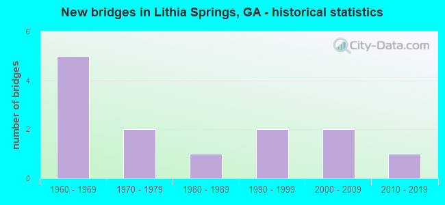
- New bridges - historical statistics
- 51960-1969
- 21970-1979
- 11980-1989
- 21990-1999
- 22000-2009
- 12010-2019

- Reconstructed bridges - Historical Statistics
- 11980-1989
- 11990-1999


- Bridge Condition - Deck
- 60.0%Good
- 40.0%Satisfactory

- Bridge Condition - Superstructure
- 40.0%Very good
- 50.0%Good
- 10.0%Satisfactory

- Bridge Condition - Channel
- 55.6%Very good
- 33.3%Good
- 11.1%Satisfactory
Find on map >> Show street view
Structure Number: 670192, Location: 1 MI SW OF AUSTELL (Lat: 33.805608, Lng: -84.652778), Route carried "on" structure: US 278, Year Built: 1983, Status: Open, Structure Length: 5.49m (18.01ft), Average Daily Traffic: 33,560 (year 2012), Truck Traffic: 1%, Average Future Daily Traffic: 50,340 (year 2032), Design Load: HS 20+Mod, Features Intersected: NOR SOUTHERN RAILROAD
Minimum Vertical Clearance: 30+ m (98+ ft), Kilometerpoint: 11.265, Lanes on structure: 5, Base Highway Network: Yes, Owner: State Highway Agency, Approaching Roadway Width: 22.9m (75.1ft), Material/Design: Prestressed concrete, Design/Construction: Stringer/Multi-beam, Number Of Spans In Main Unit: 3, Length of Maximum Span: 18.3m (60.0ft), Curb-To-Curb Width: 26.2m (86.0ft), Out-to-Out Width: 27.2m (89.2ft)
Condition: Deck: Good, Superstructure: Good, Substructure: Good, Operating Rating: 78.0 metric tons, Method Used To Determine Operating Rating: Load Factor (LF), Inventory Rating: 39.9 metric tons, Method Used To Determine Inventory Rating: Load Factor (LF), Structural Evaluation: Better than present minimum criteria, Deck Geometry: Superior to present desirable criteria, Underclear: Better than present minimum criteria, Approach Roadway Alignment: Equal to present desirable criteria, Designated Inspection Frequency: Every 24 months, Inspection Date: June 2021, Bridge Improvement Cost: $1,279,000, Roadway Improvement Cost: $128,000, Total Project Cost: $1,918,000, Deck Structure Type: Concrete Cast-file-Place
Find on map >> Show street view
Structure Number: 675105, Location: 3.4 MILES WEST OF AUSTELL (Lat: 33.816219, Lng: -84.693628), Route carried "on" structure: County highway 2121, Year Built: 1978, Status: Open, Structure Length: 6.71m (22.01ft), Average Daily Traffic: 1,930 (year 2012), Truck Traffic: 1%, Average Future Daily Traffic: 2,895 (year 2032), Design Load: HS 15, Features Intersected: SWEETWATER CREEK, Facility Carried by Structure: HOLLOMAN ROAD
Minimum Vertical Clearance: 30+ m (98+ ft), Kilometerpoint: 1.609, Lanes on structure: 2, Base Highway Network: Yes, Owner: County Highway Agency, Approaching Roadway Width: 6.1m (20.0ft), Material/Design: Concrete, Design/Construction: Tee Beam, Number Of Spans In Main Unit: 6, Length of Maximum Span: 12.2m (40.0ft), Curb-To-Curb Width: 8.7m (28.5ft), Out-to-Out Width: 9.7m (31.8ft)
Condition: Deck: Good, Superstructure: Very good, Substructure: Good, Channel: Good, Operating Rating: 37.1 metric tons, Method Used To Determine Operating Rating: Load Factor (LF), Inventory Rating: 21.7 metric tons, Method Used To Determine Inventory Rating: Load Factor (LF), Structural Evaluation: Somewhat better than minimum adequacy, Deck Geometry: Somewhat better than minimum adequacy, Waterway Adequacy: Equal to present desirable criteria, Approach Roadway Alignment: Equal to present desirable criteria, Designated Inspection Frequency: Every 24 months, Underwater Inspection Frequency: Every 60 months, Inspection Date: June 2021, Underwater Inspection Date: October 2018, Bridge Improvement Cost: $860,000, Roadway Improvement Cost: $86,000, Total Project Cost: $1,289,000, Deck Structure Type: Concrete Cast-file-Place
Find on map >> Show street view
Structure Number: 675204, Location: 4.1 MILES WEST OF AUSTELL (Lat: 33.820969, Lng: -84.705958), Route carried "on" structure: County highway 2120, Year Built: 1998, Status: Open, Structure Length: 3.47m (11.38ft), Average Daily Traffic: 1,930 (year 2012), Truck Traffic: 1%, Average Future Daily Traffic: 2,895 (year 2032), Design Load: HS 20+Mod, Features Intersected: SWEETWATER CREEK, Facility Carried by Structure: BROWN ROAD
Minimum Vertical Clearance: 30+ m (98+ ft), Kilometerpoint: 0.000, Lanes on structure: 2, Base Highway Network: Yes, Owner: County Highway Agency, Approaching Roadway Width: 6.1m (20.0ft), Material/Design: Prestressed concrete, Design/Construction: Stringer/Multi-beam, Number Of Spans In Main Unit: 3, Length of Maximum Span: 11.6m (38.1ft), Curb-To-Curb Width: 12.1m (39.7ft), Out-to-Out Width: 13.1m (43.0ft)
Condition: Deck: Good, Superstructure: Very good, Substructure: Good, Channel: Good, Operating Rating: 66.2 metric tons, Method Used To Determine Operating Rating: Load Factor (LF), Inventory Rating: 34.4 metric tons, Method Used To Determine Inventory Rating: Load Factor (LF), Structural Evaluation: Better than present minimum criteria, Deck Geometry: Equal to present minimum criteria, Waterway Adequacy: Better than present minimum criteria, Approach Roadway Alignment: Equal to present desirable criteria, Designated Inspection Frequency: Every 24 months, Inspection Date: June 2021, Bridge Improvement Cost: $445,000, Roadway Improvement Cost: $45,000, Total Project Cost: $668,000, Deck Structure Type: Concrete Cast-file-Place
Find on map >> Show street view
Structure Number: 675224, Location: 3.4 MI E OF AUSTELL (Lat: 33.820619, Lng: -84.692989), Route carried "on" structure: County highway 2121, Year Built: 2001, Status: Open, Structure Length: 1.04m (3.41ft), Average Daily Traffic: 1,930 (year 2012), Truck Traffic: 1%, Average Future Daily Traffic: 2,895 (year 2032), Design Load: HS 20+Mod, Features Intersected: SWEETWATER CREEK TRIB., Facility Carried by Structure: HOLLOMAN ROAD
Minimum Vertical Clearance: 30+ m (98+ ft), Kilometerpoint: 1.609, Lanes on structure: 2, Base Highway Network: Yes, Owner: County Highway Agency, Approaching Roadway Width: 6.1m (20.0ft), Skew: 4 degrees, Material/Design: Concrete, Design/Construction: Culvert, Number Of Spans In Main Unit: 3, Length of Maximum Span: 3.0m (9.8ft)
Condition: Channel: Very good, Culverts: Good, Operating Rating: 55.3 metric tons, Method Used To Determine Operating Rating: Field evaluation and documented engineering judgment, Inventory Rating: 32.6 metric tons, Method Used To Determine Inventory Rating: Field evaluation and documented engineering judgment, Structural Evaluation: Better than present minimum criteria, Waterway Adequacy: Equal to present desirable criteria, Approach Roadway Alignment: Equal to present desirable criteria, Designated Inspection Frequency: Every 24 months, Inspection Date: March 2021
Find on map >> Show street view
Structure Number: 970005, Location: 8.3 MI E OF DOUGLASVILLE (Lat: 33.776897, Lng: -84.605606), Route carried "on" structure: State highway 6, Year Built: 1963, Year Reconstructed: 1990, Status: Open, Structure Length: 9.20m (30.18ft), Average Daily Traffic: 59,400 (year 2012), Truck Traffic: 1%, Average Future Daily Traffic: 89,100 (year 2032), Design Load: HS 20, Features Intersected: I-20 & I-20 RAMP, Facility Carried by Structure: THORNTON ROAD
Minimum Vertical Clearance: 30+ m (98+ ft), Kilometerpoint: 4.828, Lanes on structure: 7, Lanes under structure: 7, Base Highway Network: Yes, Owner: State Highway Agency, Approaching Roadway Width: 26.8m (87.9ft), Skew: 3 degrees, Material/Design: Steel continuous, Design/Construction: Stringer/Multi-beam, Number Of Spans In Main Unit: 4, Length of Maximum Span: 25.6m (84.0ft), Curb or Sidewalk Widths: Left: 1.8m (5.9ft), Right: 1.8m (5.9ft), Curb-To-Curb Width: 26.8m (87.9ft), Out-to-Out Width: 31.2m (102.4ft)
Condition: Deck: Satisfactory, Superstructure: Good, Substructure: Good, Operating Rating: 53.5 metric tons, Method Used To Determine Operating Rating: Load Factor (LF), Inventory Rating: 31.7 metric tons, Method Used To Determine Inventory Rating: Load Factor (LF), Structural Evaluation: Better than present minimum criteria, Deck Geometry: Somewhat better than minimum adequacy, Underclear: Equal to present minimum criteria, Approach Roadway Alignment: Equal to present desirable criteria, Designated Inspection Frequency: Every 24 months, Inspection Date: November 2021, Bridge Improvement Cost: $2,789,000, Roadway Improvement Cost: $279,000, Total Project Cost: $4,184,000, Deck Structure Type: Concrete Cast-file-Place
Find on map >> Show street view
Structure Number: 970006, Location: 7 MI NE OF DOUGLASVILLE (Lat: 33.796378, Lng: -84.641050), Route carried "on" structure: State highway 6, Year Built: 1963, Year Reconstructed: 1991, Status: Open, Structure Length: 7.62m (25.00ft), Average Daily Traffic: 59,950 (year 2012), Truck Traffic: 1%, Average Future Daily Traffic: 89,925 (year 2032), Design Load: HS 20+Mod, Features Intersected: SWEETWATER CREEK, Facility Carried by Structure: THORNTON ROAD
Minimum Vertical Clearance: 30+ m (98+ ft), Kilometerpoint: 1.609, Lanes on structure: 7, Base Highway Network: Yes, Owner: State Highway Agency, Approaching Roadway Width: 25.6m (84.0ft), Skew: 21 degrees, Material/Design: Steel continuous, Design/Construction: Stringer/Multi-beam, Number Of Spans In Main Unit: 3, Length of Maximum Span: 29.3m (96.1ft), Curb-To-Curb Width: 34.1m (111.9ft), Out-to-Out Width: 35.1m (115.2ft)
Condition: Deck: Satisfactory, Superstructure: Good, Substructure: Good, Channel: Very good, Operating Rating: 29.9 metric tons, Method Used To Determine Operating Rating: Load Factor (LF), Inventory Rating: 17.2 metric tons, Method Used To Determine Inventory Rating: Load Factor (LF), Structural Evaluation: Meets minimum limits, Deck Geometry: Superior to present desirable criteria, Waterway Adequacy: Equal to present desirable criteria, Approach Roadway Alignment: Equal to present desirable criteria, Designated Inspection Frequency: Every 24 months, Inspection Date: November 2021, Bridge Improvement Cost: $2,309,000, Roadway Improvement Cost: $231,000, Total Project Cost: $3,463,000, Deck Structure Type: Concrete Cast-file-Place
Find on map >> Show street view
Structure Number: 970042, Location: 7.7 MI E OF DOUGLASVILLE (Lat: 33.792178, Lng: -84.620908), Route carried "on" structure: City street 9005, Year Built: 1975, Status: Open, Structure Length: 0.91m (2.99ft), Average Daily Traffic: 26,200 (year 2012), Truck Traffic: 1%, Average Future Daily Traffic: 39,300 (year 2032), Design Load: HS 20+Mod, Features Intersected: SWEETWATER CREEK TRIB., Facility Carried by Structure: MAXHAM ROAD
Minimum Vertical Clearance: 30+ m (98+ ft), Kilometerpoint: 0.000, Lanes on structure: 4, Base Highway Network: Yes, Owner: County Highway Agency, Approaching Roadway Width: 14.6m (47.9ft), Skew: 4 degrees, Material/Design: Concrete, Design/Construction: Culvert, Number Of Spans In Main Unit: 2, Length of Maximum Span: 4.3m (14.1ft)
Condition: Channel: Satisfactory, Culverts: Good, Operating Rating: 55.3 metric tons, Method Used To Determine Operating Rating: Field evaluation and documented engineering judgment, Inventory Rating: 32.6 metric tons, Method Used To Determine Inventory Rating: Field evaluation and documented engineering judgment, Structural Evaluation: Better than present minimum criteria, Waterway Adequacy: Superior to present desirable criteria, Approach Roadway Alignment: Equal to present desirable criteria, Designated Inspection Frequency: Every 24 months, Inspection Date: November 2021, Bridge Improvement Cost: $181,000, Roadway Improvement Cost: $18,000, Total Project Cost: $272,000
Find on map >> Show street view
Structure Number: 970043, Location: 6.5 MI E OF DOUGLASVILLE (Lat: 33.771844, Lng: -84.636994), Route carried "on" structure: City street 9040, Year Built: 1962, Status: Open, Structure Length: 6.64m (21.78ft), Average Daily Traffic: 3,290 (year 2012), Truck Traffic: 1%, Average Future Daily Traffic: 4,935 (year 2032), Design Load: HS 20+Mod, Features Intersected: I-20, Facility Carried by Structure: MT VERNON ROAD
Minimum Vertical Clearance: 30+ m (98+ ft), Kilometerpoint: 3.219, Lanes on structure: 2, Lanes under structure: 6, Owner: State Highway Agency, Approaching Roadway Width: 7.3m (24.0ft), Skew: 1 degrees, Material/Design: Steel, Design/Construction: Stringer/Multi-beam, Number Of Spans In Main Unit: 4, Length of Maximum Span: 21.3m (69.9ft), Curb or Sidewalk Widths: Left: 0.6m (2.0ft), Right: 0.6m (2.0ft), Curb-To-Curb Width: 8.5m (27.9ft), Out-to-Out Width: 10.4m (34.1ft)
Condition: Deck: Satisfactory, Superstructure: Good, Substructure: Good, Operating Rating: 57.1 metric tons, Method Used To Determine Operating Rating: Load Factor (LF), Inventory Rating: 34.4 metric tons, Method Used To Determine Inventory Rating: Load Factor (LF), Structural Evaluation: Better than present minimum criteria, Deck Geometry: Meets minimum limits, Underclear: Somewhat better than minimum adequacy, Approach Roadway Alignment: Equal to present desirable criteria, Designated Inspection Frequency: Every 24 months, Inspection Date: November 2021, Bridge Improvement Cost: $852,000, Roadway Improvement Cost: $85,000, Total Project Cost: $1,278,000, Deck Structure Type: Concrete Cast-file-Place
Find on map >> Show street view
Structure Number: 975004, Location: 5 MI NE OF DOUGLASVILLE (Lat: 33.783400, Lng: -84.627389), Route carried "on" structure: County highway 99, Year Built: 1967, Status: Open, Structure Length: 7.07m (23.20ft), Average Daily Traffic: 1,930 (year 2012), Truck Traffic: 1%, Average Future Daily Traffic: 2,895 (year 2032), Design Load: HS 20, Features Intersected: SWEETWATER CREEK, Facility Carried by Structure: SKYVIEW DRIVE
Minimum Vertical Clearance: 30+ m (98+ ft), Kilometerpoint: 3.219, Lanes on structure: 2, Base Highway Network: Yes, Owner: County Highway Agency, Approaching Roadway Width: 6.1m (20.0ft), Material/Design: Steel, Design/Construction: Stringer/Multi-beam, Number Of Spans In Main Unit: 4, Length of Maximum Span: 17.7m (58.1ft), Curb or Sidewalk Widths: Left: 0.6m (2.0ft), Right: 0.6m (2.0ft), Curb-To-Curb Width: 7.9m (25.9ft), Out-to-Out Width: 9.9m (32.5ft)
Condition: Deck: Satisfactory, Superstructure: Satisfactory, Substructure: Good, Channel: Good, Operating Rating: 46.2 metric tons, Method Used To Determine Operating Rating: Allowable Stress (AS), Inventory Rating: 32.6 metric tons, Method Used To Determine Inventory Rating: Allowable Stress (AS), Structural Evaluation: Equal to present minimum criteria, Deck Geometry: Meets minimum limits, Waterway Adequacy: Equal to present desirable criteria, Approach Roadway Alignment: Somewhat better than minimum adequacy, Length Of Structure Improvement: 47.27m (155.09ft), Designated Inspection Frequency: Every 24 months, Underwater Inspection Frequency: Every 60 months, Inspection Date: November 2021, Underwater Inspection Date: April 2018, Bridge Improvement Cost: $906,000, Roadway Improvement Cost: $91,000, Total Project Cost: $1,360,000, Deck Structure Type: Concrete Cast-file-Place
Find on map >> Show street view
Structure Number: 975005, Location: 3 MI NE OF DOUGLASVILLE (Lat: 33.774850, Lng: -84.663789), Route carried "on" structure: County highway 115, Year Built: 1963, Status: Open, Structure Length: 1.07m (3.51ft), Average Daily Traffic: 2,340 (year 2012), Truck Traffic: 1%, Average Future Daily Traffic: 3,510 (year 2032), Design Load: HS 20, Features Intersected: BEAVER RUN CREEK, Facility Carried by Structure: VULCAN DRIVE
Minimum Vertical Clearance: 30+ m (98+ ft), Kilometerpoint: 4.828, Lanes on structure: 2, Base Highway Network: Yes, Owner: County Highway Agency, Approaching Roadway Width: 9.1m (29.9ft), Material/Design: Steel, Design/Construction: Stringer/Multi-beam, Number Of Spans In Main Unit: 1, Length of Maximum Span: 10.7m (35.1ft), Curb or Sidewalk Widths: Left: 0.6m (2.0ft), Right: 0.6m (2.0ft), Curb-To-Curb Width: 8.6m (28.2ft), Out-to-Out Width: 9.9m (32.5ft)
Condition: Deck: Good, Superstructure: Good, Substructure: Good, Channel: Very good, Inventory Rating: 93.4 metric tons, Method Used To Determine Inventory Rating: Load Factor (LF), Structural Evaluation: Better than present minimum criteria, Deck Geometry: Meets minimum limits, Waterway Adequacy: Somewhat better than minimum adequacy, Approach Roadway Alignment: Equal to present desirable criteria, Designated Inspection Frequency: Every 24 months, Inspection Date: November 2021, Bridge Improvement Cost: $137,000, Roadway Improvement Cost: $14,000, Total Project Cost: $205,000, Deck Structure Type: Concrete Cast-file-Place, Wearing Surface/Protective System: Wearing Surface: Bituminous
Find on map >> Show street view
Structure Number: 975047, Location: 8.1 MI E OF DOUGLASVILLE (Lat: 33.801178, Lng: -84.621208), Route carried "on" structure: County highway 39, Year Built: 1997, Status: Open, Structure Length: 7.01m (23.00ft), Average Daily Traffic: 1,930 (year 2012), Truck Traffic: 1%, Average Future Daily Traffic: 2,895 (year 2032), Design Load: HS 20, Features Intersected: SWEETWATER CREEK, Facility Carried by Structure: OLD ALABAMA ROAD
Minimum Vertical Clearance: 30+ m (98+ ft), Kilometerpoint: 1.609, Lanes on structure: 2, Base Highway Network: Yes, Owner: County Highway Agency, Approaching Roadway Width: 7.3m (24.0ft), Material/Design: Prestressed concrete, Design/Construction: Stringer/Multi-beam, Number Of Spans In Main Unit: 4, Length of Maximum Span: 21.3m (69.9ft), Curb-To-Curb Width: 12.2m (40.0ft), Out-to-Out Width: 13.2m (43.3ft)
Condition: Deck: Good, Superstructure: Very good, Substructure: Good, Channel: Very good, Operating Rating: 54.4 metric tons, Method Used To Determine Operating Rating: Load Factor (LF), Inventory Rating: 32.6 metric tons, Method Used To Determine Inventory Rating: Load Factor (LF), Structural Evaluation: Better than present minimum criteria, Deck Geometry: Better than present minimum criteria, Waterway Adequacy: Equal to present desirable criteria, Approach Roadway Alignment: Equal to present desirable criteria, Designated Inspection Frequency: Every 24 months, Inspection Date: November 2021, Bridge Improvement Cost: $899,000, Roadway Improvement Cost: $90,000, Total Project Cost: $1,348,000, Deck Structure Type: Concrete Cast-file-Place
Find on map >> Show street view
Structure Number: 975061, Location: 1.9 MI SW OF AUSTELL (Lat: 33.783542, Lng: -84.668706), Route carried "on" structure: County highway 45, Year Built: 2007, Status: Open, Structure Length: 1.01m (3.31ft), Average Daily Traffic: 1,930 (year 2012), Truck Traffic: 1%, Average Future Daily Traffic: 2,895 (year 2032), Design Load: HS 20, Features Intersected: BEAVER CREEK, Facility Carried by Structure: NORTH COUNTY LINE
Minimum Vertical Clearance: 30+ m (98+ ft), Kilometerpoint: 1.609, Lanes on structure: 2, Base Highway Network: Yes, Owner: County Highway Agency, Approaching Roadway Width: 6.7m (22.0ft), Skew: 1 degrees, Material/Design: Concrete, Design/Construction: Culvert, Number Of Spans In Main Unit: 3, Length of Maximum Span: 3.0m (9.8ft)
Condition: Channel: Very good, Culverts: Good, Operating Rating: 55.3 metric tons, Method Used To Determine Operating Rating: Field evaluation and documented engineering judgment, Inventory Rating: 32.6 metric tons, Method Used To Determine Inventory Rating: Field evaluation and documented engineering judgment, Structural Evaluation: Better than present minimum criteria, Waterway Adequacy: Better than present minimum criteria, Approach Roadway Alignment: Equal to present desirable criteria, Designated Inspection Frequency: Every 24 months, Inspection Date: November 2021, Bridge Improvement Cost: $129,000, Roadway Improvement Cost: $13,000, Total Project Cost: $193,000
Find on map >> Show street view
Structure Number: 975069, Location: 5.5 MI E OF DOUGLASVILLE (Lat: 33.768619, Lng: -84.652039), Route carried "on" structure: City street 9370, Year Built: 2015, Status: Open, Structure Length: 10.52m (34.51ft), Average Daily Traffic: 10,120 (year 2012), Truck Traffic: 1%, Average Future Daily Traffic: 15,180 (year 2032), Design Load: HS 20, Features Intersected: I-20, Facility Carried by Structure: LEE ROAD
Minimum Vertical Clearance: 30+ m (98+ ft), Kilometerpoint: 4.828, Lanes on structure: 7, Lanes under structure: 6, Owner: State Highway Agency, Approaching Roadway Width: 11.0m (36.1ft), Material/Design: Prestressed concrete, Design/Construction: Stringer/Multi-beam, Number Of Spans In Main Unit: 4, Length of Maximum Span: 39.3m (128.9ft), Curb or Sidewalk Widths: Left: 1.8m (5.9ft), Right: 3.4m (11.2ft), Curb-To-Curb Width: 29.3m (96.1ft), Out-to-Out Width: 35.7m (117.1ft)
Condition: Deck: Good, Superstructure: Very good, Substructure: Good, Operating Rating: 54.4 metric tons, Method Used To Determine Operating Rating: Load Factor (LF), Inventory Rating: 32.6 metric tons, Method Used To Determine Inventory Rating: Load Factor (LF), Structural Evaluation: Better than present minimum criteria, Deck Geometry: Somewhat better than minimum adequacy, Underclear: Superior to present desirable criteria, Approach Roadway Alignment: Equal to present desirable criteria, Length Of Structure Improvement: 12.62m (41.40ft), Designated Inspection Frequency: Every 24 months, Inspection Date: November 2021, Bridge Improvement Cost: $30,636,000, Roadway Improvement Cost: $3,064,000, Total Project Cost: $45,954,000 ( Estimate for 2015), Deck Structure Type: Concrete Cast-file-Place
Find on map >> Show street view
Structure Number: 970005, Location: 8.3 MI E OF DOUGLASVILLE (Lat: 33.776897, Lng: -84.605606), Route carried "under" structure: Ramp Interstate 20, Structure Length: 0. m, Average Daily Traffic: 62,800 (year 1997), Truck Traffic: 1%, Features Intersected: SR 6 THORNTON ROAD, Facility Carried by Structure: THORNTON ROAD
Minimum Vertical Clearance: 5.63m (18.47ft), Kilometerpoint: 70.811, Lanes on structure: 7, Length of Maximum Span: 0.0m
Find on map >> Show street view
Structure Number: 970005, Location: 8.3 MI E OF DOUGLASVILLE (Lat: 33.776897, Lng: -84.605606), Route carried "under" structure: Interstate 20, Structure Length: 0. m, Average Daily Traffic: 106,600 (year 1998), Truck Traffic: 1%, Features Intersected: SR 6 THORNTON ROAD, Facility Carried by Structure: THORNTON ROAD
Minimum Vertical Clearance: 5.23m (17.16ft), Kilometerpoint: 70.811, Lanes on structure: 7, Length of Maximum Span: 0.0m
Find on map >> Show street view
Structure Number: 970043, Location: 6.5 MI E OF DOUGLASVILLE (Lat: 33.771844, Lng: -84.636994), Route carried "under" structure: Interstate 20, Structure Length: 0. m, Average Daily Traffic: 84,700 (year 2009), Truck Traffic: 1%, Features Intersected: M-9040 MT VERNON ROAD, Facility Carried by Structure: MT VERNON ROAD
Minimum Vertical Clearance: 5.63m (18.47ft), Kilometerpoint: 67.592, Lanes on structure: 2, Length of Maximum Span: 0.0m
Find on map >> Show street view
Structure Number: 975069, Location: 5.5 MI E OF DOUGLASVILLE (Lat: 33.768619, Lng: -84.652039), Route carried "under" structure: Interstate 20, Structure Length: 0. m, Average Daily Traffic: 84,700 (year 2009), Truck Traffic: 1%, Features Intersected: M-9370 LEE ROAD, Facility Carried by Structure: LEE ROAD
Minimum Vertical Clearance: 5.48m (17.98ft), Kilometerpoint: 65.983, Lanes on structure: 7, Length of Maximum Span: 0.0m