Bridge Statistics for Lewiston, Maine (ME)
Condition, Traffic, Stress, Structural Evaluation, Project Costs
- National Bridge Inventory (NBI) Statistics
- 49Number of bridges
- 338ft / 103mTotal length
- 4,129,166Total average daily traffic
- 354,403Total average daily truck traffic
- National Bridge Inventory (NBI) Registered Bridges for Lewiston
- No street view available for this location
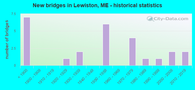
- New bridges - historical statistics
- 7Before 1900
- 11920-1929
- 21930-1939
- 61950-1959
- 41970-1979
- 11980-1989
- 11990-1999
- 22000-2009
- 22010-2019

- Reconstructed bridges - Historical Statistics
- 11980-1989
- 51990-1999
- 02000-2009
- 12010-2019


- Bridge Condition - Deck
- 29.2%Very good
- 33.3%Good
- 20.8%Satisfactory
- 12.5%Fair
- 4.2%Poor

- Bridge Condition - Superstructure
- 33.3%Very good
- 29.2%Good
- 33.3%Satisfactory
- 4.2%Fair

- Bridge Condition - Substructure
- 20.0%Very good
- 40.0%Good
- 32.0%Satisfactory
- 4.0%Fair
- 4.0%Poor

- Bridge Condition - Channel
- 26.7%Very good
- 40.0%Good
- 20.0%Satisfactory
- 6.7%Fair
- 6.7%Poor

- Bridge Condition - Culverts
- 33.3%Very good
- 66.7%Good
Find on map >> Show street view
Location: 0.1 MIL W LINCOLN ST (Lat: 33.001222, Lng: -531.335281), Route carried "under" structure: 1500, Year Built: 1011, Status: Open, Structure Length: 0.98m (3.22ft), Average Daily Traffic: 602,000 (year 0240), Truck Traffic: 5%, Average Future Daily Traffic: 3,361 (year 2036), Design Load: H 10, Features Intersected: 38740CROSS CANAN #2, Facility Carried by Structure: OXFORD STREET
Lanes on structure: 91, Lanes under structure: 99, Toll: , Approaching Roadway Width: 201.60m (661.42ft), Skew: 90 degrees, Material/Design: Concrete, Design/Construction: Slab, Number Of Spans In Main Unit: 1, Length of Maximum Span: 7.9m (25.9ft), Curb or Sidewalk Widths: Left: 1.8m (5.9ft), Right: 1.8m (5.9ft), Curb-To-Curb Width: 8.5m (27.9ft), Out-to-Out Width: 13.0m (42.7ft)
Condition: Deck: Very good, Superstructure: Very good, Substructure: Good, Channel: Good, Operating Rating: 42.1 metric tons, Method Used To Determine Operating Rating: Load and Resistance Factor Rating (LRFR) rating reported by rating factor(RF) method using HL-93 loadings, Inventory Rating: 32.4 metric tons, Method Used To Determine Inventory Rating: Load and Resistance Factor Rating (LRFR) rating reported by rating factor(RF) method using HL-93 loadings, Structural Evaluation: Better than present minimum criteria, Deck Geometry: Meets minimum limits, Waterway Adequacy: Better than present minimum criteria, Approach Roadway Alignment: Equal to present desirable criteria, Designated Inspection Frequency: Every 24 months, Inspection Date: March 2021, Deck Structure Type: Concrete Cast-file-Place, Wearing Surface/Protective System: Wearing Surface: Bituminous, Membrane: Built-up
Find on map >> Show street view
Location: 1MI E OF TOWNLINE (Lat: 37.501222, Lng: -630.351947), Route carried "under" structure: 41400, Year Built: 1011, Status: Open, Structure Length: 1.65m (5.41ft), Average Daily Traffic: 602,000 (year 0077), Truck Traffic: 8%, Average Future Daily Traffic: 1,232 (year 2036), Features Intersected: 38740M C RR, Facility Carried by Structure: RIVERSIDE ST
Lanes on structure: 72, Toll: On Interstate toll segment, Owner: County Highway Agency, Approaching Roadway Width: 201.60m (661.42ft), Skew: 90 degrees, Material/Design: Prestressed concrete, Design/Construction: Slab, Number Of Spans In Main Unit: 1, Length of Maximum Span: 15.9m (52.2ft), Curb or Sidewalk Widths: Left: 1.5m (4.9ft), Right: 0.0m, Curb-To-Curb Width: 7.3m (24.0ft), Out-to-Out Width: 10.1m (33.1ft)
Condition: Deck: Very good, Superstructure: Very good, Substructure: Very good, Operating Rating: 92.7 metric tons, Method Used To Determine Operating Rating: Load and Resistance Factor Rating (LRFR) rating reported by rating factor(RF) method using HL-93 loadings, Inventory Rating: 71.6 metric tons, Method Used To Determine Inventory Rating: Load and Resistance Factor Rating (LRFR) rating reported by rating factor(RF) method using HL-93 loadings, Structural Evaluation: Equal to present desirable criteria, Deck Geometry: Meets minimum limits, Underclear: Somewhat better than minimum adequacy, Approach Roadway Alignment: Equal to present desirable criteria, Designated Inspection Frequency: Every 24 months, Inspection Date: April 2021, Deck Structure Type: Concrete Precast Panels, Wearing Surface/Protective System: Wearing Surface: Bituminous, Membrane: Preformed Fabric
Find on map >> Show street view
Location: 77.72 MILE POINT (Lat: 62.001222, Lng: -428.335281), Route carried "under" structure: 91300, Year Built: 1011, Year Reconstructed: 1997, Status: Open, Structure Length: 2.99m (9.81ft), Average Daily Traffic: 502,000 (year 1444), Truck Traffic: 9%, Average Future Daily Traffic: 20,219 (year 2036), Design Load: H 15, Features Intersected: 38740M C RR, Facility Carried by Structure: MTPK EXIT 13
Lanes on structure: 61, Lanes under structure: 95, Toll: , Owner: Town or Township Highway Agency, Maintenance Responsibility: Corps of Engineers (Civil), Approaching Roadway Width: 201.60m (661.42ft), Skew: 50 degrees, Material/Design: Steel continuous, Design/Construction: Stringer/Multi-beam, Number Of Spans In Main Unit: 3, Length of Maximum Span: 29.9m (98.1ft), Curb-To-Curb Width: 9.8m (32.2ft), Out-to-Out Width: 10.7m (35.1ft)
Condition: Deck: Satisfactory, Superstructure: Satisfactory, Substructure: Good, Operating Rating: 46.0 metric tons, Method Used To Determine Operating Rating: Load and Resistance Factor Rating (LRFR) rating reported by rating factor(RF) method using HL-93 loadings, Inventory Rating: 35.3 metric tons, Method Used To Determine Inventory Rating: Load and Resistance Factor Rating (LRFR) rating reported by rating factor(RF) method using HL-93 loadings, Structural Evaluation: Equal to present minimum criteria, Deck Geometry: Meets minimum limits, Underclear: High priority of corrective action, Approach Roadway Alignment: Equal to present desirable criteria, Designated Inspection Frequency: Every 24 months, Inspection Date: March 2021, Deck Structure Type: Concrete Cast-file-Place, Wearing Surface/Protective System: Wearing Surface: Bituminous, Membrane: Preformed Fabric, Deck Protection: Epoxy Coated Reinforcing
Find on map >> Show street view
Location: RCHAN077.70 MILE POINT (Lat: 62.001222, Lng: -432.751947), Route carried "under" structure: Business 1300, Year Built: 1011, Year Reconstructed: 1997, Status: Open, Structure Length: 6.10m (20.01ft), Average Daily Traffic: 502,040 (year 0931), Truck Traffic: 9%, Average Future Daily Traffic: 13,042 (year 2036), Design Load: HS 20+Mod, Features Intersected: 38740RTE 196, Facility Carried by Structure: LEWISTON INTE
Lanes on structure: 61, Lanes under structure: 95, Toll: , Owner: County Highway Agency, Maintenance Responsibility: Federal Agency, Approaching Roadway Width: 201.60m (661.42ft), Skew: 50 degrees, Material/Design: Steel continuous, Design/Construction: Stringer/Multi-beam, Number Of Spans In Main Unit: 3, Length of Maximum Span: 61.0m (200.1ft), Curb-To-Curb Width: 9.1m (29.9ft), Out-to-Out Width: 10.1m (33.1ft)
Condition: Deck: Satisfactory, Superstructure: Satisfactory, Substructure: Good, Operating Rating: 38.2 metric tons, Method Used To Determine Operating Rating: Load and Resistance Factor Rating (LRFR) rating reported by rating factor(RF) method using HL-93 loadings, Inventory Rating: 29.5 metric tons, Method Used To Determine Inventory Rating: Load and Resistance Factor Rating (LRFR) rating reported by rating factor(RF) method using HL-93 loadings, Structural Evaluation: Equal to present minimum criteria, Deck Geometry: Meets minimum limits, Underclear: Meets minimum limits, Approach Roadway Alignment: Equal to present desirable criteria, Designated Inspection Frequency: Every 24 months, Inspection Date: March 2021, Deck Structure Type: Concrete Cast-file-Place, Wearing Surface/Protective System: Wearing Surface: Bituminous, Membrane: Preformed Fabric, Deck Protection: Epoxy Coated Reinforcing
Find on map >> Show street view
Location: 1.0 MI W TOWN LINE (Lat: 9.334556, Lng: -353.835278), Route carried "under" structure: Service 71400, Year Built: 1011, Status: Open, Structure Length: 1.87m (6.14ft), Average Daily Traffic: 202,000 (year 0173), Truck Traffic: 8%, Average Future Daily Traffic: 2,607 (year 2036), Design Load: Railroad, Features Intersected: 38740NO NAME BROOK, Facility Carried by Structure: CROWLEY ROAD
Lanes on structure: 72, Toll: On Interstate toll segment, Owner: State Park, Forest, or Reservation Agency, Approaching Roadway Width: 201.60m (661.42ft), Skew: 92 degrees, Material/Design: Steel, Design/Construction: Stringer/Multi-beam, Number Of Spans In Main Unit: 1, Length of Maximum Span: 18.0m (59.1ft), Curb-To-Curb Width: 8.5m (27.9ft), Out-to-Out Width: 10.0m (32.8ft)
Condition: Deck: Very good, Superstructure: Very good, Substructure: Very good, Channel: Very good, Operating Rating: 62.9 metric tons, Method Used To Determine Operating Rating: Load and Resistance Factor Rating (LRFR) rating reported by rating factor(RF) method using HL-93 loadings, Inventory Rating: 48.6 metric tons, Method Used To Determine Inventory Rating: Load and Resistance Factor Rating (LRFR) rating reported by rating factor(RF) method using HL-93 loadings, Structural Evaluation: Equal to present desirable criteria, Deck Geometry: Somewhat better than minimum adequacy, Waterway Adequacy: Equal to present minimum criteria, Approach Roadway Alignment: Equal to present minimum criteria, Designated Inspection Frequency: Every 24 months, Inspection Date: April 2021, Deck Structure Type: Concrete Cast-file-Place, Wearing Surface/Protective System: Wearing Surface: Bituminous, Membrane: Preformed Fabric
Find on map >> Show street view
Location: 0.9 MI E POND RD. (Lat: 35.834556, Lng: -517.268611), Route carried "under" structure: Service 91500, Year Built: 3031, Status: Open, Structure Length: 0.68m (2.23ft), Average Daily Traffic: 102,000 (year 0081), Truck Traffic: 5%, Average Future Daily Traffic: 1,310 (year 2036), Design Load: HS 25 or greater, Features Intersected: 38740NO NAME BROOK, Facility Carried by Structure: RANDALL ROAD
Lanes on structure: 92, Lanes under structure: 1, Toll: On Interstate toll segment, Approaching Roadway Width: 201.60m (661.42ft), Skew: 90 degrees, Material/Design: Aluminum, Iron, Design/Construction: Culvert, Number Of Spans In Main Unit: 1, Length of Maximum Span: 6.8m (22.3ft)
Condition: Channel: Fair, Culverts: Good, Operating Rating: 58.0 metric tons, Method Used To Determine Operating Rating: Load and Resistance Factor Rating (LRFR) rating reported by rating factor(RF) method using HL-93 loadings, Inventory Rating: 44.7 metric tons, Method Used To Determine Inventory Rating: Load and Resistance Factor Rating (LRFR) rating reported by rating factor(RF) method using HL-93 loadings, Structural Evaluation: Better than present minimum criteria, Waterway Adequacy: Better than present minimum criteria, Approach Roadway Alignment: Equal to present desirable criteria, Designated Inspection Frequency: Every 24 months, Inspection Date: April 2021
Find on map >> Show street view
Location: 0.1 MI W SABATTUS TL (Lat: 16.834556, Lng: -450.451944), Route carried "under" structure: 1400, Year Built: 3031, Status: Open, Structure Length: 0.67m (2.20ft), Average Daily Traffic: 102,000 (year 0319), Truck Traffic: 8%, Average Future Daily Traffic: 4,473 (year 2036), Design Load: HS 20, Features Intersected: 38740SALMON BROOK, Facility Carried by Structure: GROVE ST
Lanes on structure: 72, Lanes under structure: 1, Toll: , Owner: Town or Township Highway Agency, Approaching Roadway Width: 201.60m (661.42ft), Material/Design: Steel, Design/Construction: Culvert, Number Of Spans In Main Unit: 3, Length of Maximum Span: 1.8m (5.9ft)
Condition: Channel: Satisfactory, Culverts: Good, Inventory Rating: 97.2 metric tons, Method Used To Determine Inventory Rating: Load and Resistance Factor Rating (LRFR) rating reported by rating factor(RF) method using HL-93 loadings, Structural Evaluation: Better than present minimum criteria, Waterway Adequacy: Somewhat better than minimum adequacy, Approach Roadway Alignment: Equal to present desirable criteria, Designated Inspection Frequency: Every 24 months, Inspection Date: July 2021
Find on map >> Show street view
Location: 0.452 mi E of SR 136 (Lat: 95.001222, Lng: -411.468614), Route carried "under" structure: 61110, Year Built: 1311, Status: Open, Structure Length: 4.92m (16.14ft), Average Daily Traffic: 602,020 (year 0892), Truck Traffic: 11%, Average Future Daily Traffic: 12,488 (year 2036), Features Intersected: 38740RIVER ROAD, Facility Carried by Structure: I-95 (NB)
Lanes on structure: 11, Lanes under structure: 95, Base Highway Network: Yes, Toll: , Owner: County Highway Agency, Approaching Roadway Width: 201.60m (661.42ft), Skew: A2 degrees, Material/Design: Steel continuous, Design/Construction: Stringer/Multi-beam, Number Of Spans In Main Unit: 3, Length of Maximum Span: 23.0m (75.5ft), Curb-To-Curb Width: 11.7m (38.4ft), Out-to-Out Width: 12.7m (41.7ft)
Condition: Deck: Good, Superstructure: Satisfactory, Substructure: Satisfactory, Channel: Very good, Operating Rating: 45.7 metric tons, Method Used To Determine Operating Rating: Load and Resistance Factor Rating (LRFR) rating reported by rating factor(RF) method using HL-93 loadings, Inventory Rating: 35.3 metric tons, Method Used To Determine Inventory Rating: Load and Resistance Factor Rating (LRFR) rating reported by rating factor(RF) method using HL-93 loadings, Structural Evaluation: Equal to present minimum criteria, Deck Geometry: Equal to present minimum criteria, Underclear: Meets minimum limits, Approach Roadway Alignment: Equal to present desirable criteria, Designated Inspection Frequency: Every 24 months, Inspection Date: May 2021, Deck Structure Type: Concrete Cast-file-Place, Wearing Surface/Protective System: Wearing Surface: Bituminous, Membrane: Preformed Fabric, Deck Protection: Epoxy Coated Reinforcing
Find on map >> Show street view
Location: 0.330 mi W of SR 196 (Lat: 95.001222, Lng: -408.851947), Route carried "under" structure: 91110, Year Built: 1311, Status: Open, Structure Length: 1.51m (4.95ft), Average Daily Traffic: 602,020 (year 0598), Truck Traffic: 11%, Average Future Daily Traffic: 8,372 (year 2036), Features Intersected: 38740FERRY ROAD, Facility Carried by Structure: I-95 (NB)
Lanes on structure: 11, Lanes under structure: 95, Base Highway Network: Yes, Toll: Toll bridge is a segment, Owner: County Highway Agency, Approaching Roadway Width: 201.60m (661.42ft), Skew: A3 degrees, Material/Design: Steel continuous, Design/Construction: Girder and Floorbeam System, Number Of Spans In Main Unit: 1, Length of Maximum Span: 15.1m (49.5ft), Curb-To-Curb Width: 11.6m (38.1ft), Out-to-Out Width: 12.5m (41.0ft)
Condition: Deck: Good, Superstructure: Good, Substructure: Good, Operating Rating: 84.9 metric tons, Method Used To Determine Operating Rating: Load and Resistance Factor Rating (LRFR) rating reported by rating factor(RF) method using HL-93 loadings, Inventory Rating: 65.4 metric tons, Method Used To Determine Inventory Rating: Load and Resistance Factor Rating (LRFR) rating reported by rating factor(RF) method using HL-93 loadings, Structural Evaluation: Better than present minimum criteria, Deck Geometry: Equal to present minimum criteria, Underclear: Meets minimum limits, Approach Roadway Alignment: Equal to present minimum criteria, Designated Inspection Frequency: Every 24 months, Inspection Date: May 2021, Deck Structure Type: Concrete Cast-file-Place, Wearing Surface/Protective System: Wearing Surface: Bituminous, Membrane: Preformed Fabric, Deck Protection: Epoxy Coated Reinforcing
Find on map >> Show street view
Structure Number: 137, Location: .2 MI E TOWNLINE (Lat: 44.112669, Lng: -70.210369), Route carried "on" structure: Ramp State highway , Year Built: 1973, Status: Open, Structure Length: 5.73m (18.80ft), Average Daily Traffic: 7,293 (year 2016), Truck Traffic: 7%, Average Future Daily Traffic: 10,210 (year 2036), Design Load: HS 20+Mod, Features Intersected: M C RR, Facility Carried by Structure: VIETNAM VET EB
Minimum Vertical Clearance: 30+ m (98+ ft), Kilometerpoint: 0.290, Lanes on structure: 2, Owner: State Highway Agency, Approaching Roadway Width: 9.1m (29.9ft), Skew: 3 degrees, Material/Design: Steel continuous, Design/Construction: Stringer/Multi-beam, Number Of Spans In Main Unit: 3, Length of Maximum Span: 25.9m (85.0ft), Curb-To-Curb Width: 8.8m (28.9ft), Out-to-Out Width: 10.0m (32.8ft)
Condition: Deck: Satisfactory, Superstructure: Satisfactory, Substructure: Satisfactory, Operating Rating: 52.2 metric tons, Method Used To Determine Operating Rating: Load and Resistance Factor Rating (LRFR) rating reported by rating factor(RF) method using HL-93 loadings, Inventory Rating: 40.2 metric tons, Method Used To Determine Inventory Rating: Load and Resistance Factor Rating (LRFR) rating reported by rating factor(RF) method using HL-93 loadings, Structural Evaluation: Equal to present minimum criteria, Deck Geometry: Meets minimum limits, Underclear: Somewhat better than minimum adequacy, Approach Roadway Alignment: Equal to present desirable criteria, Designated Inspection Frequency: Every 24 months, Inspection Date: July 2020, Deck Structure Type: Concrete Cast-file-Place, Wearing Surface/Protective System: Wearing Surface: Bituminous, Membrane: Preformed Fabric
Find on map >> Show street view
Structure Number: 1371, Location: .2 MI E TOWNLINE (Lat: 44.113111, Lng: -70.210139), Route carried "on" structure: Ramp State highway , Year Built: 1973, Status: Open, Structure Length: 5.58m (18.31ft), Average Daily Traffic: 7,825 (year 2016), Truck Traffic: 7%, Average Future Daily Traffic: 10,955 (year 2036), Design Load: HS 20+Mod, Features Intersected: M C RR, Facility Carried by Structure: VIETNAM VET WB
Minimum Vertical Clearance: 30+ m (98+ ft), Kilometerpoint: 0.161, Lanes on structure: 2, Owner: State Highway Agency, Approaching Roadway Width: 8.8m (28.9ft), Skew: 1 degrees, Material/Design: Steel continuous, Design/Construction: Stringer/Multi-beam, Number Of Spans In Main Unit: 3, Length of Maximum Span: 24.4m (80.1ft), Curb or Sidewalk Widths: Left: 0.2m (0.7ft), Right: 0.2m (0.7ft), Curb-To-Curb Width: 8.8m (28.9ft), Out-to-Out Width: 10.0m (32.8ft)
Condition: Deck: Poor, Superstructure: Satisfactory, Substructure: Satisfactory, Operating Rating: 37.9 metric tons, Method Used To Determine Operating Rating: Load and Resistance Factor Rating (LRFR) rating reported by rating factor(RF) method using HL-93 loadings, Inventory Rating: 29.2 metric tons, Method Used To Determine Inventory Rating: Load and Resistance Factor Rating (LRFR) rating reported by rating factor(RF) method using HL-93 loadings, Structural Evaluation: Equal to present minimum criteria, Deck Geometry: Meets minimum limits, Underclear: Equal to present desirable criteria, Approach Roadway Alignment: Equal to present desirable criteria, Designated Inspection Frequency: Every 24 months, Inspection Date: July 2020, Deck Structure Type: Concrete Cast-file-Place, Wearing Surface/Protective System: Wearing Surface: Integral Concrete
Find on map >> Show street view
Structure Number: 1495, Location: 0.450 mi E of SR 136 (Lat: 44.069861, Lng: -70.200000), Route carried "on" structure: Interstate 95, Year Built: 1956, Status: Open, Structure Length: 4.92m (16.14ft), Average Daily Traffic: 9,180 (year 2016), Truck Traffic: 11%, Average Future Daily Traffic: 12,852 (year 2036), Design Load: HL 93, Features Intersected: RIVER ROAD
Minimum Vertical Clearance: 30+ m (98+ ft), Kilometerpoint: 361.509, Lanes on structure: 2, Lanes under structure: 2, Base Highway Network: Yes, Toll: On Interstate toll segment, Owner: State Toll Authority, Approaching Roadway Width: 11.7m (38.4ft), Skew: 2 degrees, Material/Design: Steel continuous, Design/Construction: Stringer/Multi-beam, Number Of Spans In Main Unit: 3, Length of Maximum Span: 23.0m (75.5ft), Curb-To-Curb Width: 11.7m (38.4ft), Out-to-Out Width: 12.7m (41.7ft)
Condition: Deck: Good, Superstructure: Satisfactory, Substructure: Good, Channel: Very good, Operating Rating: 45.7 metric tons, Method Used To Determine Operating Rating: Load and Resistance Factor Rating (LRFR) rating reported by rating factor(RF) method using HL-93 loadings, Inventory Rating: 35.3 metric tons, Method Used To Determine Inventory Rating: Load and Resistance Factor Rating (LRFR) rating reported by rating factor(RF) method using HL-93 loadings, Structural Evaluation: Equal to present minimum criteria, Deck Geometry: Equal to present minimum criteria, Underclear: Meets minimum limits, Approach Roadway Alignment: Equal to present desirable criteria, Designated Inspection Frequency: Every 24 months, Inspection Date: May 2021, Deck Structure Type: Concrete Cast-file-Place, Wearing Surface/Protective System: Wearing Surface: Bituminous, Membrane: Preformed Fabric, Deck Protection: Epoxy Coated Reinforcing
Find on map >> Show street view
Structure Number: 1496, Location: 0.163 mi E of River Rd (Lat: 44.071131, Lng: -70.196719), Route carried "on" structure: Interstate 95, Year Built: 1956, Year Reconstructed: 1998, Status: Open, Structure Length: 3.32m (10.89ft), Average Daily Traffic: 9,180 (year 2016), Truck Traffic: 11%, Average Future Daily Traffic: 12,852 (year 2036), Design Load: HL 93, Features Intersected: GOODARD ROAD
Minimum Vertical Clearance: 30+ m (98+ ft), Kilometerpoint: 361.201, Lanes on structure: 2, Lanes under structure: 2, Base Highway Network: Yes, Toll: On Interstate toll segment, Owner: State Toll Authority, Approaching Roadway Width: 12.6m (41.3ft), Skew: 2 degrees, Material/Design: Steel continuous, Design/Construction: Stringer/Multi-beam, Number Of Spans In Main Unit: 3, Length of Maximum Span: 12.8m (42.0ft), Curb-To-Curb Width: 12.6m (41.3ft), Out-to-Out Width: 13.6m (44.6ft)
Condition: Deck: Good, Superstructure: Satisfactory, Substructure: Good, Operating Rating: 43.4 metric tons, Method Used To Determine Operating Rating: Load and Resistance Factor Rating (LRFR) rating reported by rating factor(RF) method using HL-93 loadings, Inventory Rating: 31.4 metric tons, Method Used To Determine Inventory Rating: Load and Resistance Factor Rating (LRFR) rating reported by rating factor(RF) method using HL-93 loadings, Structural Evaluation: Equal to present minimum criteria, Deck Geometry: Better than present minimum criteria, Underclear: Meets minimum limits, Approach Roadway Alignment: Equal to present desirable criteria, Designated Inspection Frequency: Every 24 months, Inspection Date: May 2021, Deck Structure Type: Concrete Cast-file-Place, Wearing Surface/Protective System: Wearing Surface: Bituminous, Membrane: Preformed Fabric, Deck Protection: Epoxy Coated Reinforcing
Find on map >> Show street view
Structure Number: 1497, Location: 0.378 mi W of Pleasant St (Lat: 44.072239, Lng: -70.184550), Route carried "on" structure: Interstate 95, Year Built: 1956, Year Reconstructed: 2015, Status: Open, Structure Length: 4.60m (15.09ft), Average Daily Traffic: 4,650 (year 2016), Truck Traffic: 11%, Average Future Daily Traffic: 6,510 (year 2036), Design Load: HL 93, Features Intersected: ALFRED PLOURDE PKWY
Minimum Vertical Clearance: 30+ m (98+ ft), Kilometerpoint: 360.430, Lanes on structure: 2, Lanes under structure: 2, Base Highway Network: Yes, Toll: On Interstate toll segment, Owner: State Toll Authority, Approaching Roadway Width: 9.4m (30.8ft), Skew: 1 degrees, Material/Design: Steel continuous, Design/Construction: Stringer/Multi-beam, Number Of Spans In Main Unit: 3, Length of Maximum Span: 17.7m (58.1ft), Curb-To-Curb Width: 9.4m (30.8ft), Out-to-Out Width: 9.4m (30.8ft)
Condition: Deck: Good, Superstructure: Very good, Substructure: Very good, Operating Rating: 43.4 metric tons, Method Used To Determine Operating Rating: Load and Resistance Factor Rating (LRFR) rating reported by rating factor(RF) method using HL-93 loadings, Inventory Rating: 33.4 metric tons, Method Used To Determine Inventory Rating: Load and Resistance Factor Rating (LRFR) rating reported by rating factor(RF) method using HL-93 loadings, Structural Evaluation: Equal to present desirable criteria, Deck Geometry: High priority of replacement, Underclear: High priority of corrective action, Approach Roadway Alignment: Equal to present minimum criteria, Designated Inspection Frequency: Every 24 months, Inspection Date: May 2021, Deck Structure Type: Concrete Cast-file-Place, Wearing Surface/Protective System: Wearing Surface: Bituminous, Membrane: Preformed Fabric, Deck Protection: Epoxy Coated Reinforcing
Find on map >> Show street view
Structure Number: 1498, Location: 0.209 mi N of N Lisbon Rd (Lat: 44.067439, Lng: -70.162911), Route carried "on" structure: Interstate 95, Year Built: 1956, Status: Open, Structure Length: 13.40m (43.96ft), Average Daily Traffic: 6,280 (year 2016), Truck Traffic: 11%, Average Future Daily Traffic: 8,792 (year 2036), Design Load: HL 93, Features Intersected: LISBON ST/RTE 196 & MCRR
Minimum Vertical Clearance: 30+ m (98+ ft), Kilometerpoint: 358.596, Lanes on structure: 2, Lanes under structure: 2, Base Highway Network: Yes, Toll: On Interstate toll segment, Owner: State Toll Authority, Approaching Roadway Width: 11.6m (38.1ft), Skew: 6 degrees, Material/Design: Steel continuous, Design/Construction: Stringer/Multi-beam, Number Of Spans In Main Unit: 6, Length of Maximum Span: 30.9m (101.4ft), Curb-To-Curb Width: 11.6m (38.1ft), Out-to-Out Width: 12.5m (41.0ft)
Condition: Deck: Good, Superstructure: Good, Substructure: Satisfactory, Operating Rating: 48.9 metric tons, Method Used To Determine Operating Rating: Load and Resistance Factor Rating (LRFR) rating reported by rating factor(RF) method using HL-93 loadings, Inventory Rating: 37.9 metric tons, Method Used To Determine Inventory Rating: Load and Resistance Factor Rating (LRFR) rating reported by rating factor(RF) method using HL-93 loadings, Structural Evaluation: Equal to present minimum criteria, Deck Geometry: Equal to present minimum criteria, Underclear: High priority of corrective action, Approach Roadway Alignment: Equal to present minimum criteria, Designated Inspection Frequency: Every 24 months, Inspection Date: May 2021, Deck Structure Type: Concrete Cast-file-Place, Wearing Surface/Protective System: Wearing Surface: Bituminous, Membrane: Epoxy, Deck Protection: Epoxy Coated Reinforcing
Find on map >> Show street view
Structure Number: 1531, Location: IMMED. W'LY OF ROUTE 196 (Lat: 44.091950, Lng: -70.215831), Route carried "on" structure: City street , Year Built: 1973, Status: Open, Structure Length: 3.23m (10.60ft), Average Daily Traffic: 5,365 (year 2016), Truck Traffic: 5%, Average Future Daily Traffic: 7,511 (year 2036), Design Load: HS 20, Features Intersected: MAIN CANAL, Facility Carried by Structure: CEDAR STREET E B
Minimum Vertical Clearance: 30+ m (98+ ft), Kilometerpoint: 0.000, Lanes on structure: 2, Owner: State Highway Agency, Approaching Roadway Width: 7.9m (25.9ft), Skew: 6 degrees, Material/Design: Steel, Design/Construction: Stringer/Multi-beam, Number Of Spans In Main Unit: 1, Length of Maximum Span: 30.2m (99.1ft), Curb-To-Curb Width: 8.5m (27.9ft), Out-to-Out Width: 9.7m (31.8ft)
Condition: Deck: Satisfactory, Superstructure: Satisfactory, Substructure: Satisfactory, Channel: Good, Operating Rating: 50.5 metric tons, Method Used To Determine Operating Rating: Load and Resistance Factor Rating (LRFR) rating reported by rating factor(RF) method using HL-93 loadings, Inventory Rating: 38.9 metric tons, Method Used To Determine Inventory Rating: Load and Resistance Factor Rating (LRFR) rating reported by rating factor(RF) method using HL-93 loadings, Structural Evaluation: Equal to present minimum criteria, Deck Geometry: High priority of corrective action, Waterway Adequacy: Superior to present desirable criteria, Approach Roadway Alignment: Equal to present desirable criteria, Designated Inspection Frequency: Every 24 months, Inspection Date: March 2021, Deck Structure Type: Concrete Cast-file-Place, Wearing Surface/Protective System: Wearing Surface: Monolithic Concrete
Find on map >> Show street view
Structure Number: 1751, Location: .1 MI W'LY JCT LINCOLN ST (Lat: 44.093539, Lng: -70.220911), Route carried "on" structure: City street 1203, Year Built: 2017, Status: Open, Structure Length: 1.75m (5.74ft), Average Daily Traffic: 407 (year 2019), Truck Traffic: 5%, Design Load: HL 93, Features Intersected: ANDROSCOGGIN CANAL, Facility Carried by Structure: BEECH STREET
Minimum Vertical Clearance: 30+ m (98+ ft), Kilometerpoint: 0.579, Lanes on structure: 2, Owner: Town or Township Highway Agency, Approaching Roadway Width: 7.2m (23.6ft), Material/Design: Steel, Design/Construction: Truss - Thru, Number Of Spans In Main Unit: 1, Length of Maximum Span: 16.0m (52.5ft), Curb or Sidewalk Widths: Left: 0.5m (1.6ft), Right: 0.5m (1.6ft), Curb-To-Curb Width: 7.5m (24.6ft), Out-to-Out Width: 8.3m (27.2ft)
Condition: Deck: Very good, Superstructure: Very good, Substructure: Very good, Channel: Very good, Operating Rating: 42.4 metric tons, Method Used To Determine Operating Rating: Load and Resistance Factor Rating (LRFR) rating reported by rating factor(RF) method using HL-93 loadings, Inventory Rating: 32.7 metric tons, Method Used To Determine Inventory Rating: Load and Resistance Factor Rating (LRFR) rating reported by rating factor(RF) method using HL-93 loadings, Structural Evaluation: Equal to present desirable criteria, Deck Geometry: Meets minimum limits, Waterway Adequacy: Superior to present desirable criteria, Approach Roadway Alignment: Equal to present desirable criteria, Designated Inspection Frequency: Every 24 months, Critical Feature Inspection Frequency: Every 24 months, Inspection Date: August 2020, Critical Feature Inspection Date: August 2020, Deck Structure Type: Concrete Cast-file-Place, Wearing Surface/Protective System: Wearing Surface: Integral Concrete
Find on map >> Show street view
Structure Number: 2803, Location: 2.2 MI SW GREENE TL (Lat: 44.128989, Lng: -70.199111), Route carried "on" structure: State highway 202, Year Built: 2015, Status: Open, Structure Length: 0.74m (2.43ft), Average Daily Traffic: 12,763 (year 2016), Truck Traffic: 9%, Average Future Daily Traffic: 17,868 (year 2036), Design Load: HL 93, Features Intersected: STETSON BK
Minimum Vertical Clearance: 30+ m (98+ ft), Kilometerpoint: 121.892, Lanes on structure: 2, Base Highway Network: Yes, Owner: State Highway Agency, Approaching Roadway Width: 12.2m (40.0ft), Skew: 1 degrees, Material/Design: Concrete, Design/Construction: Culvert, Number Of Spans In Main Unit: 1, Length of Maximum Span: 6.8m (22.3ft), Curb-To-Curb Width: 12.2m (40.0ft), Out-to-Out Width: 12.2m (40.0ft)
Condition: Channel: Satisfactory, Culverts: Very good, Operating Rating: 47.3 metric tons, Method Used To Determine Operating Rating: Load and Resistance Factor Rating (LRFR) rating reported by rating factor(RF) method using HL-93 loadings, Inventory Rating: 36.6 metric tons, Method Used To Determine Inventory Rating: Load and Resistance Factor Rating (LRFR) rating reported by rating factor(RF) method using HL-93 loadings, Structural Evaluation: Equal to present desirable criteria, Deck Geometry: Somewhat better than minimum adequacy, Waterway Adequacy: Equal to present desirable criteria, Approach Roadway Alignment: Equal to present desirable criteria, Designated Inspection Frequency: Every 24 months, Inspection Date: October 2020, Wearing Surface/Protective System: Wearing Surface: Bituminous
Find on map >> Show street view
Structure Number: 3083, Location: .1 MI W 196 (Lat: 44.098281, Lng: -70.218700), Route carried "on" structure: State highway 202, Year Built: 1991, Status: Open, Structure Length: 2.62m (8.60ft), Average Daily Traffic: 31,702 (year 2016), Truck Traffic: 9%, Average Future Daily Traffic: 44,383 (year 2036), Design Load: HS 25 or greater, Features Intersected: MAIN CANAL
Minimum Vertical Clearance: 30+ m (98+ ft), Kilometerpoint: 118.013, Lanes on structure: 4, Base Highway Network: Yes, Owner: State Highway Agency, Approaching Roadway Width: 18.3m (60.0ft), Skew: 13 degrees, Material/Design: Steel, Design/Construction: Stringer/Multi-beam, Number Of Spans In Main Unit: 3, Length of Maximum Span: 9.2m (30.2ft), Curb or Sidewalk Widths: Left: 2.5m (8.2ft), Right: 2.1m (6.9ft), Curb-To-Curb Width: 16.5m (54.1ft), Out-to-Out Width: 19.0m (62.3ft)
Condition: Deck: Satisfactory, Superstructure: Good, Substructure: Satisfactory, Channel: Good, Operating Rating: 51.2 metric tons, Method Used To Determine Operating Rating: Load and Resistance Factor Rating (LRFR) rating reported by rating factor(RF) method using HL-93 loadings, Inventory Rating: 39.5 metric tons, Method Used To Determine Inventory Rating: Load and Resistance Factor Rating (LRFR) rating reported by rating factor(RF) method using HL-93 loadings, Structural Evaluation: Equal to present minimum criteria, Deck Geometry: Meets minimum limits, Waterway Adequacy: Superior to present desirable criteria, Approach Roadway Alignment: Equal to present desirable criteria, Designated Inspection Frequency: Every 24 months, Inspection Date: September 2021, Deck Structure Type: Concrete Cast-file-Place, Wearing Surface/Protective System: Wearing Surface: Integral Concrete
Find on map >> Show street view
Structure Number: 3201, Location: 2MI N OF RT126 OVER RT202 (Lat: 44.124531, Lng: -70.201461), Year Built: 1936, Status: Open, Structure Length: 3.93m (12.89ft), Average Future Daily Traffic: 22,574 (year 2034), Features Intersected: STATE ROUTE 202
Lanes under structure: 2, Owner: Railroad, Material/Design: Steel, Design/Construction: Girder and Floorbeam System, Number Of Spans In Main Unit: 1, Length of Maximum Span: 37.5m (123.0ft), Out-to-Out Width: 10.5m (34.4ft)
Condition: Substructure: Poor, Underclear: High priority of corrective action, Designated Inspection Frequency: Every 24 months, Inspection Date: December 2021
Find on map >> Show street view
Structure Number: 39, Location: 0.1 MI S RTE 202 (Lat: 44.095431, Lng: -70.220719), Route carried "on" structure: State highway , Year Built: 1930, Year Reconstructed: 1997, Status: Open, Structure Length: 1.43m (4.69ft), Average Daily Traffic: 10,496 (year 2016), Truck Traffic: 9%, Average Future Daily Traffic: 14,694 (year 2036), Design Load: HS 25 or greater, Features Intersected: CROSS CANAL #1, Facility Carried by Structure: LINCOLN STREET
Minimum Vertical Clearance: 30+ m (98+ ft), Kilometerpoint: 0.145, Lanes on structure: 2, Base Highway Network: Yes, Owner: State Highway Agency, Approaching Roadway Width: 11.6m (38.1ft), Material/Design: Prestressed concrete, Design/Construction: Slab, Number Of Spans In Main Unit: 1, Length of Maximum Span: 13.4m (44.0ft), Curb or Sidewalk Widths: Left: 2.0m (6.6ft), Right: 2.0m (6.6ft), Curb-To-Curb Width: 14.6m (47.9ft), Out-to-Out Width: 19.5m (64.0ft)
Condition: Deck: Very good, Superstructure: Very good, Substructure: Good, Channel: Good, Operating Rating: 55.1 metric tons, Method Used To Determine Operating Rating: Load and Resistance Factor Rating (LRFR) rating reported by rating factor(RF) method using HL-93 loadings, Inventory Rating: 42.4 metric tons, Method Used To Determine Inventory Rating: Load and Resistance Factor Rating (LRFR) rating reported by rating factor(RF) method using HL-93 loadings, Structural Evaluation: Better than present minimum criteria, Deck Geometry: Superior to present desirable criteria, Waterway Adequacy: Better than present minimum criteria, Approach Roadway Alignment: Equal to present desirable criteria, Designated Inspection Frequency: Every 24 months, Inspection Date: August 2020, Deck Structure Type: Concrete Cast-file-Place, Wearing Surface/Protective System: Wearing Surface: Bituminous, Membrane: Built-up
Find on map >> Show street view
Structure Number: 5003, Location: 400 FT W RTE #196 (Lat: 44.093819, Lng: -70.217011), Route carried "on" structure: City street , Year Built: 1927, Status: Posted for load, Structure Length: 2.26m (7.41ft), Average Daily Traffic: 4,110 (year 2016), Truck Traffic: 5%, Average Future Daily Traffic: 5,754 (year 2036), Design Load: H 15, Features Intersected: MAIN CANAL, Facility Carried by Structure: CHESTNUT ST.
Minimum Vertical Clearance: 3.91m (12.83ft), Kilometerpoint: 0.145, Lanes on structure: 2, Owner: State Highway Agency, Approaching Roadway Width: 7.3m (24.0ft), Material/Design: Concrete, Design/Construction: Arch - Thru, Number Of Spans In Main Unit: 1, Length of Maximum Span: 19.5m (64.0ft), Curb or Sidewalk Widths: Left: 2.0m (6.6ft), Right: 2.0m (6.6ft), Curb-To-Curb Width: 7.3m (24.0ft), Out-to-Out Width: 7.3m (24.0ft)
Condition: Deck: Fair, Superstructure: Fair, Substructure: Fair, Channel: Good, Operating Rating: 17.2 metric tons, Method Used To Determine Operating Rating: Load and Resistance Factor Rating (LRFR) rating reported by rating factor(RF) method using HL-93 loadings, Inventory Rating: 13.3 metric tons, Method Used To Determine Inventory Rating: Load and Resistance Factor Rating (LRFR) rating reported by rating factor(RF) method using HL-93 loadings, Structural Evaluation: Meets minimum limits, Deck Geometry: High priority of replacement, Waterway Adequacy: Superior to present desirable criteria, Approach Roadway Alignment: Equal to present desirable criteria, Bridge Posting: Required (Relationship of Operating Rating to Maximum Legal Load: 20.0 - 29.9% below), Designated Inspection Frequency: Every 24 months, Inspection Date: December 2021, Deck Structure Type: Concrete Cast-file-Place, Wearing Surface/Protective System: Wearing Surface: Monolithic Concrete
Find on map >> Show street view
Structure Number: 5689, Location: 1 MI S'LY OF JCT 202 (Lat: 44.086200, Lng: -70.213281), Route carried "on" structure: State highway , Year Built: 1958, Year Reconstructed: 1987, Status: Open, Structure Length: 2.88m (9.45ft), Average Daily Traffic: 6,236 (year 2016), Truck Traffic: 9%, Average Future Daily Traffic: 8,730 (year 2036), Design Load: H 20, Features Intersected: MAIN CANAL, Facility Carried by Structure: LINCOLN ST
Minimum Vertical Clearance: 30+ m (98+ ft), Kilometerpoint: 1.400, Lanes on structure: 2, Base Highway Network: Yes, Owner: State Highway Agency, Approaching Roadway Width: 10.4m (34.1ft), Material/Design: Steel, Design/Construction: Stringer/Multi-beam, Number Of Spans In Main Unit: 1, Length of Maximum Span: 27.1m (88.9ft), Curb or Sidewalk Widths: Left: 1.5m (4.9ft), Right: 1.5m (4.9ft), Curb-To-Curb Width: 10.4m (34.1ft), Out-to-Out Width: 14.1m (46.3ft)
Condition: Deck: Fair, Superstructure: Good, Substructure: Satisfactory, Channel: Poor, Operating Rating: 51.2 metric tons, Method Used To Determine Operating Rating: Load and Resistance Factor Rating (LRFR) rating reported by rating factor(RF) method using HL-93 loadings, Inventory Rating: 39.5 metric tons, Method Used To Determine Inventory Rating: Load and Resistance Factor Rating (LRFR) rating reported by rating factor(RF) method using HL-93 loadings, Structural Evaluation: Equal to present minimum criteria, Deck Geometry: Meets minimum limits, Waterway Adequacy: Better than present minimum criteria, Approach Roadway Alignment: Equal to present desirable criteria, Designated Inspection Frequency: Every 24 months, Inspection Date: October 2021, Deck Structure Type: Concrete Cast-file-Place, Wearing Surface/Protective System: Wearing Surface: Monolithic Concrete
Find on map >> Show street view
Structure Number: 6214, Location: IMMED. W'LY OF ROUTE 196 (Lat: 44.092181, Lng: -70.215981), Route carried "on" structure: State highway , Year Built: 1987, Status: Open, Structure Length: 2.88m (9.45ft), Average Daily Traffic: 6,602 (year 2016), Truck Traffic: 9%, Average Future Daily Traffic: 9,243 (year 2036), Design Load: HS 25 or greater, Features Intersected: MAIN CANAL, Facility Carried by Structure: CEDAR ST
Minimum Vertical Clearance: 30+ m (98+ ft), Kilometerpoint: 5.343, Lanes on structure: 3, Base Highway Network: Yes, Owner: State Highway Agency, Approaching Roadway Width: 8.2m (26.9ft), Material/Design: Steel, Design/Construction: Stringer/Multi-beam, Number Of Spans In Main Unit: 1, Length of Maximum Span: 27.1m (88.9ft), Curb or Sidewalk Widths: Left: 1.8m (5.9ft), Right: 0.0m, Curb-To-Curb Width: 8.3m (27.2ft), Out-to-Out Width: 11.1m (36.4ft)
Condition: Deck: Good, Superstructure: Very good, Substructure: Good, Channel: Good, Operating Rating: 56.7 metric tons, Method Used To Determine Operating Rating: Load and Resistance Factor Rating (LRFR) rating reported by rating factor(RF) method using HL-93 loadings, Inventory Rating: 32.4 metric tons, Method Used To Determine Inventory Rating: Load and Resistance Factor Rating (LRFR) rating reported by rating factor(RF) method using HL-93 loadings, Structural Evaluation: Better than present minimum criteria, Deck Geometry: High priority of replacement, Waterway Adequacy: Superior to present desirable criteria, Approach Roadway Alignment: Equal to present desirable criteria, Designated Inspection Frequency: Every 24 months, Inspection Date: August 2020, Deck Structure Type: Concrete Cast-file-Place, Wearing Surface/Protective System: Wearing Surface: Monolithic Concrete
Find on map >> Show street view
Structure Number: 6331, Location: 0.4 MI W OF JCT US 202 (Lat: 44.114931, Lng: -70.213489), Route carried "on" structure: State highway , Year Built: 1973, Status: Open, Structure Length: 13.87m (45.51ft), Average Daily Traffic: 16,697 (year 2017), Truck Traffic: 7%, Average Future Daily Traffic: 21,171 (year 2036), Design Load: HS 20+Mod, Features Intersected: ANDROSCOGGIN RIVER, Facility Carried by Structure: VIET VET'S CONNECT
Minimum Vertical Clearance: 30+ m (98+ ft), Kilometerpoint: 1.432, Lanes on structure: 4, Base Highway Network: Yes, Owner: State Highway Agency, Approaching Roadway Width: 11.3m (37.1ft), Skew: 30 degrees, Material/Design: Steel continuous, Design/Construction: Stringer/Multi-beam, Number Of Spans In Main Unit: 3, Length of Maximum Span: 54.9m (180.1ft), Curb or Sidewalk Widths: Left: 0.2m (0.7ft), Right: 0.2m (0.7ft), Curb-To-Curb Width: 21.9m (71.9ft), Out-to-Out Width: 23.7m (77.8ft)
Condition: Deck: Fair, Superstructure: Good, Substructure: Satisfactory, Channel: Satisfactory, Operating Rating: 49.6 metric tons, Method Used To Determine Operating Rating: Load and Resistance Factor Rating (LRFR) rating reported by rating factor(RF) method using HL-93 loadings, Inventory Rating: 38.2 metric tons, Method Used To Determine Inventory Rating: Load and Resistance Factor Rating (LRFR) rating reported by rating factor(RF) method using HL-93 loadings, Structural Evaluation: Equal to present minimum criteria, Deck Geometry: Better than present minimum criteria, Waterway Adequacy: Superior to present desirable criteria, Approach Roadway Alignment: Equal to present desirable criteria, Designated Inspection Frequency: Every 24 months, Underwater Inspection Frequency: Every 60 months, Inspection Date: August 2021, Underwater Inspection Date: June 2020, Deck Structure Type: Concrete Cast-file-Place, Wearing Surface/Protective System: Wearing Surface: Bituminous, Membrane: Preformed Fabric
Find on map >> Show street view
Structure Number: 6383, Location: Rt 202 & Russell Street (Lat: 44.111969, Lng: -70.208169), Route carried "on" structure: State highway , Year Built: 2005, Status: Open, Structure Length: 3.99m (13.09ft), Average Daily Traffic: 15,846 (year 2016), Truck Traffic: 7%, Average Future Daily Traffic: 22,184 (year 2036), Design Load: HS 25 or greater, Features Intersected: Main Street, Facility Carried by Structure: Russell Street
Minimum Vertical Clearance: 30+ m (98+ ft), Kilometerpoint: 1.996, Lanes on structure: 2, Lanes under structure: 4, Base Highway Network: Yes, Owner: State Highway Agency, Approaching Roadway Width: 12.2m (40.0ft), Material/Design: Prestressed concrete, Design/Construction: Tee Beam, Number Of Spans In Main Unit: 1, Length of Maximum Span: 38.4m (126.0ft), Curb-To-Curb Width: 7.9m (25.9ft), Out-to-Out Width: 12.8m (42.0ft)
Condition: Deck: Very good, Superstructure: Good, Substructure: Very good, Operating Rating: 50.5 metric tons, Method Used To Determine Operating Rating: Load and Resistance Factor Rating (LRFR) rating reported by rating factor(RF) method using HL-93 loadings, Inventory Rating: 39.2 metric tons, Method Used To Determine Inventory Rating: Load and Resistance Factor Rating (LRFR) rating reported by rating factor(RF) method using HL-93 loadings, Structural Evaluation: Better than present minimum criteria, Deck Geometry: High priority of replacement, Underclear: Better than present minimum criteria, Approach Roadway Alignment: Equal to present desirable criteria, Designated Inspection Frequency: Every 24 months, Inspection Date: July 2020, Deck Structure Type: Concrete Cast-file-Place, Wearing Surface/Protective System: Wearing Surface: Bituminous, Membrane: Preformed Fabric
Find on map >> Show street view
Structure Number: 6384, Location: .2 MI E TOWNLINE (Lat: 44.112911, Lng: -70.210169), Route carried "on" structure: Ramp State highway , Year Built: 2001, Status: Open, Structure Length: 3.25m (10.66ft), Average Daily Traffic: 17,635 (year 2019), Truck Traffic: 5%, Average Future Daily Traffic: 10,955 (year 2036), Design Load: HS 25 or greater, Features Intersected: M C RR, Facility Carried by Structure: VETERANS MEMORIAL
Minimum Vertical Clearance: 30+ m (98+ ft), Kilometerpoint: 1.802, Lanes on structure: 2, Owner: State Highway Agency, Approaching Roadway Width: 12.8m (42.0ft), Skew: 2 degrees, Material/Design: Steel, Design/Construction: Stringer/Multi-beam, Number Of Spans In Main Unit: 1, Length of Maximum Span: 30.5m (100.1ft), Curb-To-Curb Width: 12.0m (39.4ft), Out-to-Out Width: 12.8m (42.0ft)
Condition: Deck: Very good, Superstructure: Very good, Substructure: Good, Operating Rating: 45.0 metric tons, Method Used To Determine Operating Rating: Load and Resistance Factor Rating (LRFR) rating reported by rating factor(RF) method using HL-93 loadings, Inventory Rating: 34.7 metric tons, Method Used To Determine Inventory Rating: Load and Resistance Factor Rating (LRFR) rating reported by rating factor(RF) method using HL-93 loadings, Structural Evaluation: Better than present minimum criteria, Deck Geometry: Superior to present desirable criteria, Underclear: Superior to present desirable criteria, Approach Roadway Alignment: Equal to present desirable criteria, Designated Inspection Frequency: Every 24 months, Inspection Date: August 2020, Deck Structure Type: Concrete Precast Panels, Wearing Surface/Protective System: Wearing Surface: Bituminous
Find on map >> Show street view
Structure Number: 6497, Location: .33 mi W of SR 196 (Lat: 44.069150, Lng: -70.173661), Route carried "on" structure: Interstate 95, Year Built: 1956, Year Reconstructed: 1995, Status: Open, Structure Length: 1.51m (4.95ft), Average Daily Traffic: 6,280 (year 2016), Truck Traffic: 11%, Average Future Daily Traffic: 8,792 (year 2036), Features Intersected: Ferry Road
Minimum Vertical Clearance: 30+ m (98+ ft), Kilometerpoint: 9999.999, Lanes on structure: 2, Lanes under structure: 2, Base Highway Network: Yes, Toll: On Interstate toll segment, Owner: State Toll Authority, Approaching Roadway Width: 11.6m (38.1ft), Skew: 3 degrees, Material/Design: Steel, Design/Construction: Stringer/Multi-beam, Number Of Spans In Main Unit: 1, Length of Maximum Span: 15.1m (49.5ft), Curb-To-Curb Width: 11.6m (38.1ft), Out-to-Out Width: 12.5m (41.0ft)
Condition: Deck: Good, Superstructure: Good, Substructure: Good, Operating Rating: 84.9 metric tons, Method Used To Determine Operating Rating: Load and Resistance Factor Rating (LRFR) rating reported by rating factor(RF) method using HL-93 loadings, Inventory Rating: 65.4 metric tons, Method Used To Determine Inventory Rating: Load and Resistance Factor Rating (LRFR) rating reported by rating factor(RF) method using HL-93 loadings, Structural Evaluation: Better than present minimum criteria, Deck Geometry: Equal to present minimum criteria, Underclear: Meets minimum limits, Approach Roadway Alignment: Equal to present minimum criteria, Designated Inspection Frequency: Every 24 months, Inspection Date: May 2021, Deck Structure Type: Concrete Cast-file-Place, Wearing Surface/Protective System: Wearing Surface: Bituminous, Membrane: Preformed Fabric, Deck Protection: Epoxy Coated Reinforcing
Find on map >> Show street view
Location: 0.265 mi. N of Crowley Rd (Lat: 44.072108, Lng: -70.184628), Route carried "under" structure: Bypass 4A400, Structure Length: 0. m, Average Daily Traffic: 3,000 (year 2014), Truck Traffic: 5%, Features Intersected: GROVE STREET, Facility Carried by Structure: RD INV 01 00506
Minimum Vertical Clearance: 4.34m (14.24ft), Kilometerpoint: 0.483, Lanes on structure: 2, Length of Maximum Span: 0.0m
Find on map >> Show street view
Location: 0.265 mi. N of Crowley Rd (Lat: 44.070000, Lng: -70.120000), Route carried "under" structure: Bypass 4B400, Structure Length: 0. m, Average Daily Traffic: 3,000 (year 2014), Truck Traffic: 5%, Features Intersected: GROVE STREET, Facility Carried by Structure: RD INV 01 00506
Minimum Vertical Clearance: 4.34m (14.24ft), Kilometerpoint: 0.483, Lanes on structure: 2, Length of Maximum Span: 0.0m
Find on map >> Show street view
Location: 0.962 mi E of Grove St (Lat: 44.072108, Lng: -70.184628), Route carried "under" structure: Bypass 52110, Structure Length: 0. m, Average Daily Traffic: 5,670 (year 2014), Truck Traffic: 10%, Features Intersected: RD INV 01 00393, Facility Carried by Structure: INT 95 NB
Minimum Vertical Clearance: 4.32m (14.17ft), Kilometerpoint: 133.769, Lanes on structure: 4, Toll: On Interstate toll segment, Length of Maximum Span: 0.0m
Find on map >> Show street view
Location: .159 mi N of Desmarais Dr (Lat: 44.072108, Lng: -70.184628), Route carried "under" structure: Bypass 72110, Structure Length: 0. m, Average Daily Traffic: 4,050 (year 2014), Truck Traffic: 10%, Features Intersected: ST RTE 9, Facility Carried by Structure: INT 95 NB
Minimum Vertical Clearance: 4.39m (14.40ft), Kilometerpoint: 136.360, Lanes on structure: 4, Toll: On Interstate toll segment, Length of Maximum Span: 0.0m
Find on map >> Show street view
Location: 0.635 mi E of SR 9 (Lat: 44.072108, Lng: -70.184628), Route carried "under" structure: Bypass 82110, Structure Length: 0. m, Average Daily Traffic: 4,580 (year 2014), Truck Traffic: 11%, Features Intersected: RD INV 01 00409, Facility Carried by Structure: INT 95 NB
Minimum Vertical Clearance: 4.34m (14.24ft), Kilometerpoint: 137.486, Lanes on structure: 4, Toll: On Interstate toll segment, Length of Maximum Span: 0.0m
Find on map >> Show street view
Location: 0.367 mi NE of Furbush (Lat: 44.072108, Lng: -70.184628), Route carried "under" structure: Bypass 92110, Structure Length: 0. m, Average Daily Traffic: 4,580 (year 2014), Truck Traffic: 11%, Features Intersected: RD INV 01 00409, Facility Carried by Structure: INT 95 NB
Minimum Vertical Clearance: 4.34m (14.24ft), Kilometerpoint: 138.452, Lanes on structure: 4, Toll: On Interstate toll segment, Length of Maximum Span: 0.0m
Find on map >> Show street view
Location: 0.252 mi NW Poplar Drive (Lat: 44.072108, Lng: -70.184628), Route carried "under" structure: Spur 2110, Structure Length: 0. m, Average Daily Traffic: 4,580 (year 2014), Truck Traffic: 11%, Features Intersected: RD INV 01 00400, Facility Carried by Structure: I-95 NB
Minimum Vertical Clearance: 4.32m (14.17ft), Kilometerpoint: 141.204, Lanes on structure: 4, Toll: On Interstate toll segment, Length of Maximum Span: 0.0m
Find on map >> Show street view
Location: 0.071 mi N of Terry Circ (Lat: 44.072108, Lng: -70.184628), Route carried "under" structure: Spur 12110, Structure Length: 0. m, Average Daily Traffic: 4,580 (year 2014), Truck Traffic: 11%, Features Intersected: MAXWELL ROAD, Facility Carried by Structure: INT 95
Minimum Vertical Clearance: 4.34m (14.24ft), Kilometerpoint: 142.668, Lanes on structure: 4, Toll: On Interstate toll segment, Length of Maximum Span: 0.0m
Find on map >> Show street view
Location: 077.70 MILE POINT (Lat: 44.075475, Lng: -70.182703), Route carried "under" structure: Business 2310, Structure Length: 0. m, Average Daily Traffic: 13,150 (year 2014), Truck Traffic: 5%, Features Intersected: LEWISTON INTERCHAN, Facility Carried by Structure: RTE 196
Minimum Vertical Clearance: 7.52m (24.67ft), Kilometerpoint: 27.166, Lanes on structure: 4, Length of Maximum Span: 0.0m
Find on map >> Show street view
Location: 0.096 mi W of Old Hotel (Lat: 44.072108, Lng: -70.184628), Route carried "under" structure: Ramp 92110, Structure Length: 0. m, Average Daily Traffic: 8,550 (year 2014), Truck Traffic: 10%, Features Intersected: POLAND SPRING ROAD, Facility Carried by Structure: I-95
Minimum Vertical Clearance: 4.50m (14.76ft), Kilometerpoint: 116.758, Lanes on structure: 4, Toll: On Interstate toll segment, Length of Maximum Span: 0.0m
Find on map >> Show street view
Location: 0.452 mi E of SR 136 (Lat: 44.069686, Lng: -70.200008), Route carried "under" structure: 62400, Structure Length: 0. m, Average Daily Traffic: 2,830 (year 2014), Truck Traffic: 5%, Features Intersected: I-95 (NB), Facility Carried by Structure: RIVER ROAD
Minimum Vertical Clearance: 5.44m (17.85ft), Kilometerpoint: 5.102, Lanes on structure: 2, Length of Maximum Span: 0.0m
Find on map >> Show street view
Location: 0.172 mi E of River Rd (Lat: 44.071014, Lng: -70.196631), Route carried "under" structure: 72400, Structure Length: 0. m, Average Daily Traffic: 1,755 (year 2014), Truck Traffic: 5%, Features Intersected: I-95 (NB), Facility Carried by Structure: GOODARD ROAD
Minimum Vertical Clearance: 4.98m (16.34ft), Kilometerpoint: 0.370, Lanes on structure: 2, Length of Maximum Span: 0.0m
Find on map >> Show street view
Location: 0.380 mi W of Pleasant St (Lat: 44.072108, Lng: -70.184628), Route carried "under" structure: 82300, Structure Length: 0. m, Average Daily Traffic: 8,208 (year 2014), Truck Traffic: 5%, Features Intersected: I-95 (NB), Facility Carried by Structure: LEWISTON INTERCHAN
Minimum Vertical Clearance: 4.11m (13.48ft), Kilometerpoint: 1.706, Lanes on structure: 2, Length of Maximum Span: 0.0m
Find on map >> Show street view
Location: 0.330 mi W of SR 196 (Lat: 44.069031, Lng: -70.173753), Route carried "under" structure: 92500, Structure Length: 0. m, Average Daily Traffic: 1,397 (year 2014), Truck Traffic: 5%, Features Intersected: I-95 (NB), Facility Carried by Structure: FERRY ROAD
Minimum Vertical Clearance: 4.32m (14.17ft), Kilometerpoint: 4.941, Lanes on structure: 2, Length of Maximum Span: 0.0m
Find on map >> Show street view
Location: 0.197 mi N of N Lisbon Rd (Lat: 44.067222, Lng: -70.162233), Route carried "under" structure: Interstate 2310, Structure Length: 0. m, Average Daily Traffic: 15,280 (year 2014), Truck Traffic: 5%, Features Intersected: I-95 (NB), Facility Carried by Structure: LISBON ST/RTE 196
Minimum Vertical Clearance: 5.06m (16.60ft), Kilometerpoint: 25.154, Lanes on structure: 4, Length of Maximum Span: 0.0m
Find on map >> Show street view
Location: 0.036 mi N of Gould Rd (Lat: 44.066606, Lng: -70.154561), Route carried "under" structure: Interstate 12110, Structure Length: 0. m, Average Daily Traffic: 5,670 (year 2014), Truck Traffic: 10%, Features Intersected: OLD LISBON RD, Facility Carried by Structure: I-95
Minimum Vertical Clearance: 4.29m (14.07ft), Kilometerpoint: 129.842, Lanes on structure: 4, Toll: On Interstate toll segment, Length of Maximum Span: 0.0m
Find on map >> Show street view
Location: 0.081 mi NW of Crowley (Lat: 44.070875, Lng: -70.138758), Route carried "under" structure: Interstate 22110, Structure Length: 0. m, Average Daily Traffic: 5,670 (year 2014), Truck Traffic: 10%, Features Intersected: WEBSTER ROAD, Facility Carried by Structure: I-95
Minimum Vertical Clearance: 4.31m (14.14ft), Kilometerpoint: 131.017, Lanes on structure: 4, Toll: On Interstate toll segment, Length of Maximum Span: 0.0m
Find on map >> Show street view
Location: 0.450 mi E of SR 136 (Lat: 44.069856, Lng: -70.200000), Route carried "on" structure: County highway 52400, Structure Length: 0. m, Average Daily Traffic: 2,830 (year 2014), Truck Traffic: 5%, Features Intersected: I-95(SB), Facility Carried by Structure: RIVER ROAD
Minimum Vertical Clearance: 5.59m (18.34ft), Kilometerpoint: 5.150, Lanes on structure: 2, Length of Maximum Span: 0.0m
Find on map >> Show street view
Location: 0.163 mi E of River Rd (Lat: 44.071131, Lng: -70.196722), Route carried "on" structure: County highway 62400, Structure Length: 0. m, Average Daily Traffic: 1,755 (year 2014), Truck Traffic: 5%, Features Intersected: I-95(SB), Facility Carried by Structure: GOODARD ROAD
Minimum Vertical Clearance: 4.75m (15.58ft), Kilometerpoint: 0.338, Lanes on structure: 2, Length of Maximum Span: 0.0m
Find on map >> Show street view
Location: 0.209 mi N of N Lisbon Rd (Lat: 44.067442, Lng: -70.162903), Route carried "on" structure: County highway 82310, Structure Length: 0. m, Average Daily Traffic: 15,280 (year 2014), Truck Traffic: 5%, Features Intersected: I-95(SB), Facility Carried by Structure: LISBON ST/RTE 196
Minimum Vertical Clearance: 4.98m (16.34ft), Kilometerpoint: 25.315, Lanes on structure: 4, Length of Maximum Span: 0.0m
Find on map >> Show street view
Location: 2MI N OF RT126 (Lat: 44.124517, Lng: -70.201431), Route carried "under" structure: US 12310, Structure Length: 0. m, Average Daily Traffic: 16,124 (year 2014), Truck Traffic: 5%, Features Intersected: MAINE CENTRAL RAIL, Facility Carried by Structure: STATE ROUTE 202
Minimum Vertical Clearance: 4.34m (14.24ft), Kilometerpoint: 121.345, Lanes on structure: 3, Length of Maximum Span: 0.0m