Bridge Statistics for Leesburg, Florida (FL)
Condition, Traffic, Stress, Structural Evaluation, Project Costs
- National Bridge Inventory (NBI) Statistics
- 20Number of bridges
- 233ft / 71.3mTotal length
- 421,677Total average daily traffic
- 70,634Total average daily truck traffic
- National Bridge Inventory (NBI) Registered Bridges for Leesburg
- No street view available for this location
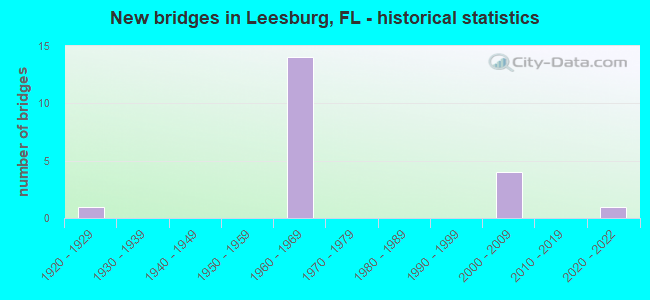
- New bridges - historical statistics
- 11920-1929
- 141960-1969
- 42000-2009
- 12020-2022

- Reconstructed bridges - Historical Statistics
- 11950-1959
- 01960-1969
- 01970-1979
- 51980-1989


- Bridge Condition - Deck
- 69.2%Good
- 30.8%Satisfactory

- Bridge Condition - Superstructure
- 15.4%Very good
- 53.8%Good
- 30.8%Satisfactory

- Bridge Condition - Substructure
- 7.7%Very good
- 61.5%Good
- 30.8%Satisfactory
Find on map >> Show street view
Structure Number: 110001, Location: 5.2 MI S OF SUMTER COUNTY (Lat: 28.715353, Lng: -81.896508), Route carried "on" structure: County highway 33, Year Built: 1964, Status: Open, Structure Length: 8.56m (28.08ft), Average Daily Traffic: 6,100 (year 2020), Truck Traffic: 12%, Average Future Daily Traffic: 10,584 (year 2042), Design Load: HS 20, Features Intersected: SR 91 TPK
Minimum Vertical Clearance: 30+ m (98+ ft), Kilometerpoint: 41.828, Lanes on structure: 2, Lanes under structure: 4, Base Highway Network: Yes, Owner: State Toll Authority, Approaching Roadway Width: 9.2m (30.2ft), Skew: 4 degrees, Material/Design: Prestressed concrete, Design/Construction: Stringer/Multi-beam, Number Of Spans In Main Unit: 4, Length of Maximum Span: 25.1m (82.3ft), Curb or Sidewalk Widths: Left: 0.6m (2.0ft), Right: 0.6m (2.0ft), Curb-To-Curb Width: 9.2m (30.2ft), Out-to-Out Width: 10.4m (34.1ft)
Condition: Deck: Good, Superstructure: Good, Substructure: Good, Operating Rating: 50.1 metric tons, Method Used To Determine Operating Rating: Load and Resistance Factor (LRFR), Inventory Rating: 38.6 metric tons, Method Used To Determine Inventory Rating: Load and Resistance Factor (LRFR), Structural Evaluation: Better than present minimum criteria, Deck Geometry: Meets minimum limits, Underclear: Somewhat better than minimum adequacy, Approach Roadway Alignment: Better than present minimum criteria, Designated Inspection Frequency: Every 24 months, Inspection Date: November 2021, Deck Structure Type: Concrete Cast-file-Place
Find on map >> Show street view
Structure Number: 110004, Location: US-27 SB - Helena Run (Lat: 28.764769, Lng: -81.881447), Route carried "on" structure: US 25, Year Built: 1927, Year Reconstructed: 1950, Status: Open, Structure Length: 1.37m (4.49ft), Average Daily Traffic: 17,500 (year 2020), Truck Traffic: 11%, Average Future Daily Traffic: 30,362 (year 2042), Design Load: H 15, Features Intersected: Helena Run, Facility Carried by Structure: US-27 SB
Minimum Vertical Clearance: 30+ m (98+ ft), Kilometerpoint: 0.248, Lanes on structure: 2, Owner: State Highway Agency, Approaching Roadway Width: 8.7m (28.5ft), Material/Design: Concrete, Design/Construction: Tee Beam, Number Of Spans In Main Unit: 1, Length of Maximum Span: 13.1m (43.0ft), Curb-To-Curb Width: 8.5m (27.9ft), Out-to-Out Width: 10.1m (33.1ft)
Condition: Deck: Good, Superstructure: Very good, Substructure: Satisfactory, Channel: Good, Operating Rating: 48.6 metric tons, Method Used To Determine Operating Rating: Load Factor (LF), Inventory Rating: 29.2 metric tons, Method Used To Determine Inventory Rating: Load Factor (LF), Structural Evaluation: Equal to present minimum criteria, Deck Geometry: High priority of corrective action, Waterway Adequacy: Equal to present desirable criteria, Approach Roadway Alignment: Equal to present desirable criteria, Designated Inspection Frequency: Every 24 months, Underwater Inspection Frequency: Every 24 months, Inspection Date: August 2020, Underwater Inspection Date: August 2020, Deck Structure Type: Concrete Cast-file-Place, Wearing Surface/Protective System: Wearing Surface: Bituminous
Find on map >> Show street view
Structure Number: 110016, Location: 3.7 MI S OF SUMTER CO LN (Lat: 28.731822, Lng: -81.914028), Route carried "on" structure: State highway 91, Year Built: 1964, Year Reconstructed: 1991, Status: Open, Structure Length: 7.88m (25.85ft), Average Daily Traffic: 23,500 (year 2020), Truck Traffic: 21%, Average Future Daily Traffic: 40,772 (year 2042), Design Load: HS 20+Mod, Features Intersected: CR 48
Minimum Vertical Clearance: 30+ m (98+ ft), Kilometerpoint: 32.493, Lanes on structure: 2, Lanes under structure: 2, Base Highway Network: Yes, Toll: On toll road, Owner: State Toll Authority, Approaching Roadway Width: 12.8m (42.0ft), Material/Design: Prestressed concrete, Design/Construction: Stringer/Multi-beam, Number Of Spans In Main Unit: 4, Length of Maximum Span: 24.1m (79.1ft), Curb-To-Curb Width: 12.3m (40.4ft), Out-to-Out Width: 13.2m (43.3ft)
Condition: Deck: Satisfactory, Superstructure: Good, Substructure: Good, Operating Rating: 35.4 metric tons, Method Used To Determine Operating Rating: Load and Resistance Factor (LRFR), Inventory Rating: 30.2 metric tons, Method Used To Determine Inventory Rating: Load and Resistance Factor (LRFR), Structural Evaluation: Better than present minimum criteria, Deck Geometry: Better than present minimum criteria, Underclear: Equal to present minimum criteria, Approach Roadway Alignment: Equal to present desirable criteria, Designated Inspection Frequency: Every 24 months, Inspection Date: November 2021, Deck Structure Type: Concrete Cast-file-Place
Find on map >> Show street view
Structure Number: 110029, Location: 3.7MI S OF SUMTER CO LINE (Lat: 28.731958, Lng: -81.913900), Route carried "on" structure: State highway 91, Year Built: 1964, Year Reconstructed: 1991, Status: Open, Structure Length: 7.88m (25.85ft), Average Daily Traffic: 23,500 (year 2020), Truck Traffic: 21%, Average Future Daily Traffic: 40,772 (year 2042), Design Load: HS 20+Mod, Features Intersected: CR 48
Minimum Vertical Clearance: 30+ m (98+ ft), Kilometerpoint: 32.493, Lanes on structure: 2, Lanes under structure: 2, Base Highway Network: Yes, Toll: On toll road, Owner: State Toll Authority, Approaching Roadway Width: 12.4m (40.7ft), Material/Design: Prestressed concrete, Design/Construction: Stringer/Multi-beam, Number Of Spans In Main Unit: 4, Length of Maximum Span: 24.1m (79.1ft), Curb-To-Curb Width: 12.4m (40.7ft), Out-to-Out Width: 13.2m (43.3ft)
Condition: Deck: Good, Superstructure: Good, Substructure: Good, Operating Rating: 35.4 metric tons, Method Used To Determine Operating Rating: Load and Resistance Factor (LRFR), Inventory Rating: 30.2 metric tons, Method Used To Determine Inventory Rating: Load and Resistance Factor (LRFR), Structural Evaluation: Better than present minimum criteria, Deck Geometry: Better than present minimum criteria, Underclear: Equal to present minimum criteria, Approach Roadway Alignment: Equal to present desirable criteria, Designated Inspection Frequency: Every 24 months, Inspection Date: November 2021, Deck Structure Type: Concrete Cast-file-Place
Find on map >> Show street view
Structure Number: 110039, Location: 1.4 MILES S OF CR 33 (Lat: 28.699736, Lng: -81.880281), Route carried "on" structure: State highway 91, Year Built: 1964, Year Reconstructed: 1991, Status: Open, Structure Length: 4.88m (16.01ft), Average Daily Traffic: 23,500 (year 2020), Truck Traffic: 21%, Average Future Daily Traffic: 40,772 (year 2042), Design Load: HS 20+Mod, Features Intersected: PALATLAKAHA RIVER
Minimum Vertical Clearance: 30+ m (98+ ft), Kilometerpoint: 27.655, Lanes on structure: 2, Base Highway Network: Yes, Toll: On toll road, Owner: State Toll Authority, Approaching Roadway Width: 12.2m (40.0ft), Skew: 4 degrees, Material/Design: Prestressed concrete, Design/Construction: Slab, Number Of Spans In Main Unit: 5, Length of Maximum Span: 9.8m (32.2ft), Curb-To-Curb Width: 12.2m (40.0ft), Out-to-Out Width: 13.1m (43.0ft)
Condition: Deck: Satisfactory, Superstructure: Satisfactory, Substructure: Satisfactory, Channel: Good, Operating Rating: 34.9 metric tons, Method Used To Determine Operating Rating: Load and Resistance Factor (LRFR), Inventory Rating: 30.6 metric tons, Method Used To Determine Inventory Rating: Load and Resistance Factor (LRFR), Structural Evaluation: Equal to present minimum criteria, Deck Geometry: Better than present minimum criteria, Waterway Adequacy: Equal to present desirable criteria, Approach Roadway Alignment: Equal to present desirable criteria, Designated Inspection Frequency: Every 24 months, Underwater Inspection Frequency: Every 24 months, Inspection Date: November 2021, Underwater Inspection Date: November 2021, Deck Structure Type: Concrete Precast Panels
Find on map >> Show street view
Structure Number: 110055, Location: US-27 NB - Helena Run (Lat: 28.764814, Lng: -81.881269), Route carried "on" structure: US 25, Year Built: 1965, Year Reconstructed: 1994, Status: Open, Structure Length: 3.17m (10.40ft), Average Daily Traffic: 17,500 (year 2020), Truck Traffic: 11%, Average Future Daily Traffic: 30,362 (year 2042), Design Load: HS 20, Features Intersected: Helena Run, Facility Carried by Structure: US-27 NB
Minimum Vertical Clearance: 30+ m (98+ ft), Kilometerpoint: 0.233, Lanes on structure: 2, Base Highway Network: Yes, Owner: State Highway Agency, Approaching Roadway Width: 10.1m (33.1ft), Skew: 2 degrees, Material/Design: Prestressed concrete, Design/Construction: Stringer/Multi-beam, Number Of Spans In Main Unit: 3, Length of Maximum Span: 10.4m (34.1ft), Curb-To-Curb Width: 12.2m (40.0ft), Out-to-Out Width: 13.3m (43.6ft)
Condition: Deck: Good, Superstructure: Good, Substructure: Satisfactory, Channel: Good, Operating Rating: 63.9 metric tons, Method Used To Determine Operating Rating: Load Factor (LF), Inventory Rating: 40.1 metric tons, Method Used To Determine Inventory Rating: Load Factor (LF), Structural Evaluation: Equal to present minimum criteria, Deck Geometry: Better than present minimum criteria, Waterway Adequacy: Equal to present desirable criteria, Approach Roadway Alignment: Equal to present desirable criteria, Designated Inspection Frequency: Every 24 months, Underwater Inspection Frequency: Every 24 months, Inspection Date: August 2020, Underwater Inspection Date: August 2020, Deck Structure Type: Concrete Cast-file-Place, Wearing Surface/Protective System: Wearing Surface: Monolithic Concrete
Find on map >> Show street view
Structure Number: 110062, Location: US-27 NB - Palatlakaha C (Lat: 28.737619, Lng: -81.870719), Route carried "on" structure: US 25, Year Built: 1965, Status: Open, Structure Length: 4.18m (13.71ft), Average Daily Traffic: 14,000 (year 2020), Truck Traffic: 8%, Average Future Daily Traffic: 24,290 (year 2042), Design Load: HS 20, Features Intersected: Palatlakaha Creek, Facility Carried by Structure: US-27 NB
Minimum Vertical Clearance: 30+ m (98+ ft), Kilometerpoint: 51.270, Lanes on structure: 2, Base Highway Network: Yes, Owner: State Highway Agency, Approaching Roadway Width: 12.2m (40.0ft), Skew: 1 degrees, Material/Design: Prestressed concrete, Design/Construction: Stringer/Multi-beam, Number Of Spans In Main Unit: 3, Length of Maximum Span: 13.7m (44.9ft), Curb-To-Curb Width: 12.2m (40.0ft), Out-to-Out Width: 12.8m (42.0ft)
Condition: Deck: Satisfactory, Superstructure: Satisfactory, Substructure: Good, Channel: Good, Operating Rating: 61.1 metric tons, Method Used To Determine Operating Rating: Load Factor (LF), Inventory Rating: 37.4 metric tons, Method Used To Determine Inventory Rating: Load Factor (LF), Structural Evaluation: Equal to present minimum criteria, Deck Geometry: Better than present minimum criteria, Waterway Adequacy: Equal to present desirable criteria, Approach Roadway Alignment: Equal to present desirable criteria, Designated Inspection Frequency: Every 24 months, Underwater Inspection Frequency: Every 24 months, Inspection Date: September 2021, Underwater Inspection Date: September 2021, Deck Structure Type: Concrete Cast-file-Place, Wearing Surface/Protective System: Wearing Surface: Monolithic Concrete
Find on map >> Show street view
Structure Number: 110074, Location: 0.9 MILES N OF US 27 (Lat: 28.684442, Lng: -81.863992), Route carried "on" structure: City street , Year Built: 1964, Status: Open, Structure Length: 6.07m (19.91ft), Average Daily Traffic: 45,300 (year 2016), Truck Traffic: 17%, Average Future Daily Traffic: 78,596 (year 2038), Design Load: H 20, Features Intersected: SR 91 TPK, Facility Carried by Structure: BRIDGES RD 289.83
Minimum Vertical Clearance: 30+ m (98+ ft), Kilometerpoint: 25.329, Lanes on structure: 2, Lanes under structure: 4, Owner: State Toll Authority, Approaching Roadway Width: 6.1m (20.0ft), Skew: 2 degrees, Material/Design: Prestressed concrete, Design/Construction: Stringer/Multi-beam, Number Of Spans In Main Unit: 4, Length of Maximum Span: 18.6m (61.0ft), Curb or Sidewalk Widths: Left: 0.6m (2.0ft), Right: 0.6m (2.0ft), Curb-To-Curb Width: 8.5m (27.9ft), Out-to-Out Width: 10.4m (34.1ft)
Condition: Deck: Good, Superstructure: Satisfactory, Substructure: Good, Operating Rating: 49.8 metric tons, Method Used To Determine Operating Rating: Load Factor (LF), Inventory Rating: 34.3 metric tons, Method Used To Determine Inventory Rating: Load Factor (LF), Structural Evaluation: Equal to present minimum criteria, Deck Geometry: Meets minimum limits, Underclear: Meets minimum limits, Approach Roadway Alignment: Equal to present desirable criteria, Designated Inspection Frequency: Every 24 months, Inspection Date: November 2021, Deck Structure Type: Concrete Cast-file-Place
Find on map >> Show street view
Structure Number: 110075, Location: 1.4 MILES S OF CR 33 (Lat: 28.699992, Lng: -81.880236), Route carried "on" structure: State highway 91, Year Built: 1964, Year Reconstructed: 1991, Status: Open, Structure Length: 4.88m (16.01ft), Average Daily Traffic: 23,500 (year 2020), Truck Traffic: 21%, Average Future Daily Traffic: 40,772 (year 2042), Design Load: HS 20+Mod, Features Intersected: PALATLAKAHA RIVER
Minimum Vertical Clearance: 30+ m (98+ ft), Kilometerpoint: 27.673, Lanes on structure: 2, Base Highway Network: Yes, Toll: On toll road, Owner: State Toll Authority, Approaching Roadway Width: 13.5m (44.3ft), Skew: 4 degrees, Material/Design: Prestressed concrete, Design/Construction: Slab, Number Of Spans In Main Unit: 5, Length of Maximum Span: 9.8m (32.2ft), Curb-To-Curb Width: 12.3m (40.4ft), Out-to-Out Width: 13.1m (43.0ft)
Condition: Deck: Satisfactory, Superstructure: Satisfactory, Substructure: Satisfactory, Channel: Good, Operating Rating: 34.9 metric tons, Method Used To Determine Operating Rating: Load and Resistance Factor (LRFR), Inventory Rating: 30.6 metric tons, Method Used To Determine Inventory Rating: Load and Resistance Factor (LRFR), Structural Evaluation: Equal to present minimum criteria, Deck Geometry: Better than present minimum criteria, Waterway Adequacy: Equal to present desirable criteria, Approach Roadway Alignment: Equal to present desirable criteria, Designated Inspection Frequency: Every 24 months, Underwater Inspection Frequency: Every 24 months, Inspection Date: November 2021, Underwater Inspection Date: November 2021, Deck Structure Type: Concrete Precast Panels
Find on map >> Show street view
Structure Number: 110092, Location: US-27 SB - Palatlakaha Cr (Lat: 28.737517, Lng: -81.870875), Route carried "on" structure: US 25, Year Built: 2006, Status: Open, Structure Length: 4.54m (14.90ft), Average Daily Traffic: 14,000 (year 2020), Truck Traffic: 8%, Average Future Daily Traffic: 24,290 (year 2042), Design Load: HS 20, Features Intersected: Palatlakaha Creek, Facility Carried by Structure: US-27 SB
Minimum Vertical Clearance: 30+ m (98+ ft), Kilometerpoint: 51.266, Lanes on structure: 2, Base Highway Network: Yes, Owner: State Highway Agency, Approaching Roadway Width: 10.8m (35.4ft), Skew: 1 degrees, Material/Design: Prestressed concrete, Design/Construction: Stringer/Multi-beam, Number Of Spans In Main Unit: 3, Length of Maximum Span: 14.9m (48.9ft), Curb-To-Curb Width: 12.2m (40.0ft), Out-to-Out Width: 13.1m (43.0ft)
Condition: Deck: Good, Superstructure: Very good, Substructure: Good, Channel: Good, Operating Rating: 81.1 metric tons, Method Used To Determine Operating Rating: Load Factor (LF), Inventory Rating: 48.6 metric tons, Method Used To Determine Inventory Rating: Load Factor (LF), Structural Evaluation: Better than present minimum criteria, Deck Geometry: Better than present minimum criteria, Waterway Adequacy: Equal to present desirable criteria, Approach Roadway Alignment: Equal to present desirable criteria, Designated Inspection Frequency: Every 24 months, Underwater Inspection Frequency: Every 24 months, Inspection Date: September 2021, Underwater Inspection Date: September 2021, Deck Structure Type: Concrete Cast-file-Place, Wearing Surface/Protective System: Wearing Surface: Monolithic Concrete
Find on map >> Show street view
Structure Number: 1106, Location: 1.5 MI S OF SUMTER COUNTY (Lat: 28.755094, Lng: -81.938419), Route carried "on" structure: County highway 470, Year Built: 2004, Status: Open, Structure Length: 8.05m (26.41ft), Average Daily Traffic: 8,200 (year 2020), Truck Traffic: 7%, Average Future Daily Traffic: 14,227 (year 2042), Design Load: HL 93, Features Intersected: SR 91 TPK
Minimum Vertical Clearance: 30+ m (98+ ft), Kilometerpoint: 1.481, Lanes on structure: 2, Lanes under structure: 6, Owner: State Toll Authority, Approaching Roadway Width: 13.4m (44.0ft), Skew: 4 degrees, Material/Design: Prestressed concrete, Design/Construction: Stringer/Multi-beam, Number Of Spans In Main Unit: 2, Length of Maximum Span: 40.2m (131.9ft), Curb-To-Curb Width: 13.4m (44.0ft), Out-to-Out Width: 14.4m (47.2ft)
Condition: Deck: Good, Superstructure: Good, Substructure: Very good, Operating Rating: 62.3 metric tons, Method Used To Determine Operating Rating: Load Factor (LF), Inventory Rating: 53.5 metric tons, Method Used To Determine Inventory Rating: Load Factor (LF), Structural Evaluation: Better than present minimum criteria, Deck Geometry: Equal to present minimum criteria, Underclear: Superior to present desirable criteria, Approach Roadway Alignment: Equal to present desirable criteria, Designated Inspection Frequency: Every 24 months, Inspection Date: November 2021, Deck Structure Type: Concrete Cast-file-Place
Find on map >> Show street view
Structure Number: 110802, Location: .1 miles W. of CR-44 (Lat: 28.823692, Lng: -81.833475), Route carried "on" structure: State highway 500, Year Built: 2007, Status: Open, Structure Length: 0.64m (2.10ft), Average Daily Traffic: 32,977 (year 2020), Truck Traffic: 5%, Average Future Daily Traffic: 57,215 (year 2042), Design Load: HS 20, Features Intersected: Canal, Facility Carried by Structure: US-441
Minimum Vertical Clearance: 30+ m (98+ ft), Kilometerpoint: 12.434, Lanes on structure: 8, Owner: State Highway Agency, Approaching Roadway Width: 26.2m (86.0ft), Skew: 23 degrees, Material/Design: Concrete, Design/Construction: Culvert, Number Of Spans In Main Unit: 2, Length of Maximum Span: 3.0m (9.8ft)
Condition: Channel: Good, Culverts: Good, Operating Rating: 86.5 metric tons, Method Used To Determine Operating Rating: Load Factor (LF), Inventory Rating: 51.9 metric tons, Method Used To Determine Inventory Rating: Load Factor (LF), Structural Evaluation: Better than present minimum criteria, Waterway Adequacy: Equal to present desirable criteria, Approach Roadway Alignment: Equal to present desirable criteria, Designated Inspection Frequency: Every 24 months, Underwater Inspection Frequency: Every 24 months, Inspection Date: January 2021, Underwater Inspection Date: January 2021
Find on map >> Show street view
Structure Number: 114023, Location: 0.1 Mi. East of US-27 (Lat: 28.748014, Lng: -81.874761), Route carried "on" structure: County highway 48, Year Built: 1968, Status: Open, Structure Length: 4.21m (13.81ft), Average Daily Traffic: 8,700 (year 2021), Truck Traffic: 22%, Average Future Daily Traffic: 15,095 (year 2042), Design Load: HS 20, Features Intersected: PALATLAKAHA CREEK
Minimum Vertical Clearance: 30+ m (98+ ft), Kilometerpoint: 11.788, Lanes on structure: 2, Owner: County Highway Agency, Approaching Roadway Width: 7.4m (24.3ft), Skew: 2 degrees, Material/Design: Prestressed concrete, Design/Construction: Stringer/Multi-beam, Number Of Spans In Main Unit: 3, Length of Maximum Span: 14.0m (45.9ft), Curb or Sidewalk Widths: Left: 0.5m (1.6ft), Right: 0.5m (1.6ft), Curb-To-Curb Width: 9.3m (30.5ft), Out-to-Out Width: 10.6m (34.8ft)
Condition: Deck: Good, Superstructure: Good, Substructure: Good, Channel: Good, Operating Rating: 47.8 metric tons, Method Used To Determine Operating Rating: Allowable Stress (AS), Inventory Rating: 33.9 metric tons, Method Used To Determine Inventory Rating: Allowable Stress (AS), Structural Evaluation: Better than present minimum criteria, Deck Geometry: High priority of corrective action, Waterway Adequacy: Better than present minimum criteria, Approach Roadway Alignment: Equal to present desirable criteria, Designated Inspection Frequency: Every 24 months, Inspection Date: August 2021, Deck Structure Type: Concrete Cast-file-Place
Find on map >> Show street view
Structure Number: 114051, Location: 0.75 mi East of CR-33 (Lat: 28.679664, Lng: -81.884608), Route carried "on" structure: County highway 567, Year Built: 1967, Status: Open, Structure Length: 4.94m (16.21ft), Average Daily Traffic: 1,300 (year 2021), Truck Traffic: 7%, Average Future Daily Traffic: 2,256 (year 2042), Design Load: H 20, Features Intersected: Palatlakaha River
Minimum Vertical Clearance: 30+ m (98+ ft), Kilometerpoint: 7.751, Lanes on structure: 2, Owner: County Highway Agency, Approaching Roadway Width: 7.3m (24.0ft), Material/Design: Prestressed concrete, Design/Construction: Stringer/Multi-beam, Number Of Spans In Main Unit: 3, Length of Maximum Span: 16.5m (54.1ft), Curb or Sidewalk Widths: Left: 0.5m (1.6ft), Right: 0.5m (1.6ft), Curb-To-Curb Width: 8.5m (27.9ft), Out-to-Out Width: 10.1m (33.1ft)
Condition: Deck: Good, Superstructure: Good, Substructure: Good, Channel: Good, Operating Rating: 70.6 metric tons, Method Used To Determine Operating Rating: Load Factor (LF), Inventory Rating: 43.3 metric tons, Method Used To Determine Inventory Rating: Load Factor (LF), Structural Evaluation: Better than present minimum criteria, Deck Geometry: Somewhat better than minimum adequacy, Waterway Adequacy: Equal to present desirable criteria, Approach Roadway Alignment: Equal to present desirable criteria, Designated Inspection Frequency: Every 24 months, Inspection Date: August 2021, Deck Structure Type: Concrete Cast-file-Place
Find on map >> Show street view
Structure Number: 110001, Location: 5.2 MI S OF SUMTER COUNTY (Lat: 28.715353, Lng: -81.896508), Route carried "under" structure: State highway 91, Year Built: 1964, Structure Length: 0. m, Average Daily Traffic: 47,000 (year 2020), Truck Traffic: 21%, Features Intersected: SR 91 TPK, Facility Carried by Structure: CR 33 293.0
Minimum Vertical Clearance: 4.97m (16.31ft), Kilometerpoint: 30.014, Lanes on structure: 2, Lanes under structure: 4, Toll: On toll road, Material/Design: Prestressed concrete, Design/Construction: Stringer/Multi-beam, Length of Maximum Span: 25.1m (82.3ft)
Find on map >> Show street view
Structure Number: 110016, Location: 3.7 MI S OF SUMTER CO LN (Lat: 28.731822, Lng: -81.914028), Route carried "under" structure: County highway 48, Year Built: 1964, Structure Length: 0. m, Average Daily Traffic: 3,000 (year 2020), Truck Traffic: 7%, Features Intersected: CR 48, Facility Carried by Structure: SR 91 TPK SB 294.2
Minimum Vertical Clearance: 6.91m (22.67ft), Kilometerpoint: 6.944, Lanes on structure: 2, Lanes under structure: 2, Material/Design: Prestressed concrete, Design/Construction: Stringer/Multi-beam, Length of Maximum Span: 24.1m (79.1ft)
Find on map >> Show street view
Structure Number: 110029, Location: 3.7MI S OF SUMTER CO LINE (Lat: 28.731958, Lng: -81.913900), Route carried "under" structure: County highway 48, Year Built: 1964, Structure Length: 0. m, Average Daily Traffic: 3,000 (year 2020), Truck Traffic: 7%, Features Intersected: CR 48, Facility Carried by Structure: SR 91 TPK NB 294.2
Minimum Vertical Clearance: 6.91m (22.67ft), Kilometerpoint: 6.965, Lanes on structure: 2, Lanes under structure: 2, Material/Design: Prestressed concrete, Design/Construction: Stringer/Multi-beam, Length of Maximum Span: 24.1m (79.1ft)
Find on map >> Show street view
Structure Number: 110074, Location: 0.9 MILES N OF US 27 (Lat: 28.684442, Lng: -81.863992), Route carried "under" structure: State highway 91, Year Built: 1964, Structure Length: 0. m, Average Daily Traffic: 47,000 (year 2020), Truck Traffic: 21%, Features Intersected: SR 91 TPK, Facility Carried by Structure: BRIDGES RD 289.83
Minimum Vertical Clearance: 4.94m (16.21ft), Kilometerpoint: 25.347, Lanes on structure: 2, Lanes under structure: 4, Toll: On toll road, Material/Design: Prestressed concrete, Design/Construction: Stringer/Multi-beam, Length of Maximum Span: 18.6m (61.0ft)
Find on map >> Show street view
Structure Number: 1106, Location: 1.5 MI S OF SUMTER COUNTY (Lat: 28.755094, Lng: -81.938419), Route carried "under" structure: State highway 91, Year Built: 2004, Structure Length: 0. m, Average Daily Traffic: 47,000 (year 2020), Truck Traffic: 21%, Features Intersected: SR 91 TPK, Facility Carried by Structure: CR 470 296.7
Minimum Vertical Clearance: 5.26m (17.26ft), Kilometerpoint: 36.022, Lanes on structure: 2, Lanes under structure: 6, Toll: On toll road, Material/Design: Prestressed concrete, Design/Construction: Stringer/Multi-beam, Length of Maximum Span: 40.2m (131.9ft)
Find on map >> Show street view
Structure Number: 184122, Location: SR 44 at Morse Blvd. (Lat: 28.823333, Lng: -81.886667), Route carried "under" structure: State highway 44, Year Built: 2020, Structure Length: 0. m, Average Daily Traffic: 15,100 (year 2020), Truck Traffic: 14%, Features Intersected: SR-44, Facility Carried by Structure: Multi Modal Path
Minimum Vertical Clearance: 5.49m (18.01ft), Kilometerpoint: 27.037, Lanes under structure: 4, Material/Design: Steel, Design/Construction: Truss - Thru, Length of Maximum Span: 88.4m (290.0ft)