Bridge Statistics for Largo, Florida (FL)
Condition, Traffic, Stress, Structural Evaluation, Project Costs
- National Bridge Inventory (NBI) Statistics
- 37Number of bridges
- 663ft / 202mTotal length
- 860,708Total average daily traffic
- 42,525Total average daily truck traffic
- National Bridge Inventory (NBI) Registered Bridges for Largo
- No street view available for this location
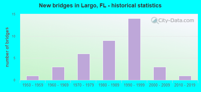
- New bridges - historical statistics
- 11950-1959
- 31960-1969
- 61970-1979
- 91980-1989
- 141990-1999
- 32000-2009
- 12010-2019


- Bridge Condition - Deck
- 14.3%Very good
- 50.0%Good
- 21.4%Satisfactory
- 7.1%Fair
- 7.1%Poor

- Bridge Condition - Superstructure
- 13.3%Very good
- 73.3%Good
- 6.7%Fair
- 6.7%Poor
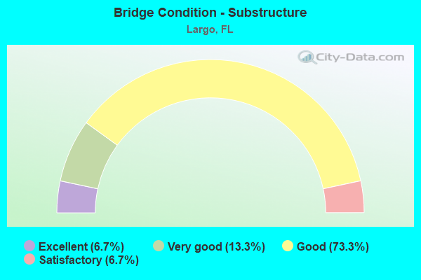
- Bridge Condition - Substructure
- 6.7%Excellent
- 13.3%Very good
- 73.3%Good
- 6.7%Satisfactory
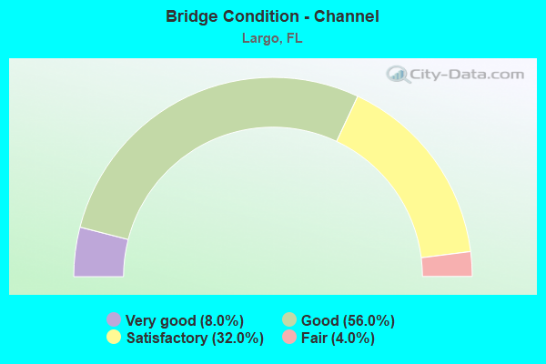
- Bridge Condition - Channel
- 8.0%Very good
- 56.0%Good
- 32.0%Satisfactory
- 4.0%Fair

- Bridge Condition - Culverts
- 78.6%Good
- 21.4%Satisfactory
Find on map >> Show street view
Structure Number: 15002, Location: 1.2MI NORTH OF SR-688 (Lat: 27.896728, Lng: -82.828469), Route carried "on" structure: County highway 233, Year Built: 1954, Status: Open, Structure Length: 1.10m (3.61ft), Average Daily Traffic: 14,000 (year 2020), Truck Traffic: 4%, Average Future Daily Traffic: 24,290 (year 2042), Design Load: HS 20, Features Intersected: CHURCH CREEK, Facility Carried by Structure: INDIAN ROCKS RD.
Minimum Vertical Clearance: 30+ m (98+ ft), Kilometerpoint: 1.918, Lanes on structure: 2, Owner: County Highway Agency, Approaching Roadway Width: 7.0m (23.0ft), Skew: 3 degrees, Material/Design: Concrete, Design/Construction: Culvert, Number Of Spans In Main Unit: 3, Length of Maximum Span: 3.7m (12.1ft)
Condition: Channel: Good, Culverts: Satisfactory, Operating Rating: 60.4 metric tons, Method Used To Determine Operating Rating: Load Factor (LF), Inventory Rating: 36.3 metric tons, Method Used To Determine Inventory Rating: Load Factor (LF), Structural Evaluation: Equal to present minimum criteria, Waterway Adequacy: Equal to present minimum criteria, Approach Roadway Alignment: Equal to present desirable criteria, Designated Inspection Frequency: Every 24 months, Underwater Inspection Frequency: Every 24 months, Inspection Date: September 2021, Underwater Inspection Date: August 2021
Find on map >> Show street view
Structure Number: 15007, Location: 0.6 MI EAST OF ALT US-19 (Lat: 27.894653, Lng: -82.776669), Route carried "on" structure: State highway 688, Year Built: 1962, Year Reconstructed: 2015, Status: Open, Structure Length: 1.35m (4.43ft), Average Daily Traffic: 60,000 (year 2020), Truck Traffic: 5%, Average Future Daily Traffic: 104,100 (year 2042), Design Load: HL 93, Features Intersected: LONG BRANCH CANAL
Minimum Vertical Clearance: 30+ m (98+ ft), Kilometerpoint: 8.330, Lanes on structure: 7, Base Highway Network: Yes, Owner: State Highway Agency, Approaching Roadway Width: 25.1m (82.3ft), Skew: 20 degrees, Material/Design: Concrete, Design/Construction: Culvert, Number Of Spans In Main Unit: 4, Length of Maximum Span: 3.2m (10.5ft)
Condition: Channel: Good, Culverts: Good, Operating Rating: 44.5 metric tons, Method Used To Determine Operating Rating: Load and Resistance Factor (LRFR), Inventory Rating: 34.4 metric tons, Method Used To Determine Inventory Rating: Load and Resistance Factor (LRFR), Structural Evaluation: Better than present minimum criteria, Waterway Adequacy: Better than present minimum criteria, Approach Roadway Alignment: Equal to present desirable criteria, Designated Inspection Frequency: Every 24 months, Underwater Inspection Frequency: Every 24 months, Inspection Date: March 2020, Underwater Inspection Date: Febuary 2020
Find on map >> Show street view
Structure Number: 150192, Location: 0.7MI N OF SR-688 (Lat: 27.903369, Lng: -82.728278), Route carried "on" structure: US 19, Year Built: 1990, Status: Open, Structure Length: 8.11m (26.61ft), Average Daily Traffic: 79,000 (year 2020), Truck Traffic: 5%, Average Future Daily Traffic: 137,065 (year 2042), Design Load: HL 93, Features Intersected: 66TH ST (SR-693)
Minimum Vertical Clearance: 30+ m (98+ ft), Kilometerpoint: 23.138, Lanes on structure: 6, Lanes under structure: 3, Base Highway Network: Yes, Owner: State Highway Agency, Approaching Roadway Width: 34.2m (112.2ft), Skew: 33 degrees, Material/Design: Prestressed concrete continuous, Design/Construction: Stringer/Multi-beam, Number Of Spans In Main Unit: 2, Length of Maximum Span: 40.5m (132.9ft), Curb-To-Curb Width: 34.2m (112.2ft), Out-to-Out Width: 35.7m (117.1ft)
Condition: Deck: Good, Superstructure: Good, Substructure: Very good, Operating Rating: 44.7 metric tons, Method Used To Determine Operating Rating: Load and Resistance Factor (LRFR), Inventory Rating: 30.7 metric tons, Method Used To Determine Inventory Rating: Load and Resistance Factor (LRFR), Structural Evaluation: Better than present minimum criteria, Deck Geometry: Superior to present desirable criteria, Underclear: Equal to present minimum criteria, Approach Roadway Alignment: Equal to present desirable criteria, Designated Inspection Frequency: Every 24 months, Inspection Date: March 2020, Deck Structure Type: Concrete Cast-file-Place
Find on map >> Show street view
Structure Number: 150193, Location: 0.5 MILE NORTH OF SR-686 (Lat: 27.923675, Lng: -82.730469), Route carried "on" structure: US 19, Year Built: 1989, Status: Open, Structure Length: 3.28m (10.76ft), Average Daily Traffic: 86,500 (year 2020), Truck Traffic: 4%, Average Future Daily Traffic: 150,078 (year 2042), Design Load: HS 20+Mod, Features Intersected: WHITNEY ROAD
Minimum Vertical Clearance: 30+ m (98+ ft), Kilometerpoint: 25.429, Lanes on structure: 6, Lanes under structure: 4, Base Highway Network: Yes, Owner: State Highway Agency, Approaching Roadway Width: 34.1m (111.9ft), Skew: 30 degrees, Material/Design: Prestressed concrete, Design/Construction: Stringer/Multi-beam, Number Of Spans In Main Unit: 1, Length of Maximum Span: 32.8m (107.6ft), Curb-To-Curb Width: 34.1m (111.9ft), Out-to-Out Width: 36.0m (118.1ft)
Condition: Deck: Very good, Superstructure: Very good, Substructure: Good, Inventory Rating: 59.5 metric tons, Method Used To Determine Inventory Rating: Load Factor (LF), Structural Evaluation: Better than present minimum criteria, Deck Geometry: Superior to present desirable criteria, Underclear: Superior to present desirable criteria, Approach Roadway Alignment: Equal to present desirable criteria, Designated Inspection Frequency: Every 24 months, Inspection Date: March 2020, Deck Structure Type: Concrete Cast-file-Place
Find on map >> Show street view
Structure Number: 150194, Location: INTERCHANGE SR-686 US-19 (Lat: 27.916306, Lng: -82.729778), Route carried "on" structure: US 19, Year Built: 1989, Status: Open, Structure Length: 12.83m (42.09ft), Average Daily Traffic: 86,500 (year 2020), Truck Traffic: 4%, Average Future Daily Traffic: 150,078 (year 2042), Design Load: HS 20+Mod, Features Intersected: SR-686 EAST BAY DRIVE
Minimum Vertical Clearance: 30+ m (98+ ft), Kilometerpoint: 24.560, Lanes on structure: 6, Lanes under structure: 8, Base Highway Network: Yes, Owner: State Highway Agency, Approaching Roadway Width: 34.9m (114.5ft), Skew: 30 degrees, Material/Design: Steel continuous, Design/Construction: Box Beam or Girders - Single/Spread, Number Of Spans In Main Unit: 3, Length of Maximum Span: 60.4m (198.2ft), Curb-To-Curb Width: 34.1m (111.9ft), Out-to-Out Width: 35.7m (117.1ft)
Condition: Deck: Good, Superstructure: Good, Substructure: Good, Operating Rating: 61.1 metric tons, Method Used To Determine Operating Rating: Load Factor (LF), Inventory Rating: 36.6 metric tons, Method Used To Determine Inventory Rating: Load Factor (LF), Structural Evaluation: Better than present minimum criteria, Deck Geometry: Superior to present desirable criteria, Underclear: Equal to present minimum criteria, Approach Roadway Alignment: Equal to present desirable criteria, Designated Inspection Frequency: Every 24 months, Inspection Date: March 2020, Deck Structure Type: Concrete Cast-file-Place
Find on map >> Show street view
Structure Number: 150204, Location: 4.3MI SOUTH OF SR-60 (Lat: 27.893744, Lng: -82.722497), Route carried "on" structure: US 19, Year Built: 1990, Status: Open, Structure Length: 16.50m (54.13ft), Average Daily Traffic: 79,000 (year 2020), Truck Traffic: 5%, Average Future Daily Traffic: 137,065 (year 2042), Design Load: HS 20+Mod, Features Intersected: SR-688/ULMERTON RD
Minimum Vertical Clearance: 30+ m (98+ ft), Kilometerpoint: 21.894, Lanes on structure: 6, Lanes under structure: 10, Base Highway Network: Yes, Owner: State Highway Agency, Approaching Roadway Width: 33.8m (110.9ft), Skew: 33 degrees, Material/Design: Steel continuous, Design/Construction: Box Beam or Girders - Single/Spread, Number Of Spans In Main Unit: 3, Length of Maximum Span: 69.6m (228.3ft), Curb-To-Curb Width: 33.8m (110.9ft), Out-to-Out Width: 35.6m (116.8ft)
Condition: Deck: Good, Superstructure: Good, Substructure: Good, Operating Rating: 74.4 metric tons, Method Used To Determine Operating Rating: Allowable Stress (AS), Inventory Rating: 30.8 metric tons, Method Used To Determine Inventory Rating: Allowable Stress (AS), Structural Evaluation: Better than present minimum criteria, Deck Geometry: Superior to present desirable criteria, Underclear: Better than present minimum criteria, Approach Roadway Alignment: Equal to present desirable criteria, Designated Inspection Frequency: Every 24 months, Inspection Date: March 2020, Deck Structure Type: Concrete Cast-file-Place
Find on map >> Show street view
Structure Number: 150218, Location: 1.4 MILE N OF SR-688 (Lat: 27.911722, Lng: -82.729444), Route carried "on" structure: US 19, Year Built: 1988, Status: Open, Structure Length: 0.98m (3.22ft), Average Daily Traffic: 86,500 (year 2020), Truck Traffic: 4%, Average Future Daily Traffic: 150,078 (year 2042), Design Load: HS 20+Mod, Features Intersected: LONG BRANCH CREEK
Minimum Vertical Clearance: 30+ m (98+ ft), Kilometerpoint: 24.105, Lanes on structure: 14, Base Highway Network: Yes, Owner: State Highway Agency, Approaching Roadway Width: 85.3m (279.9ft), Skew: 39 degrees, Material/Design: Concrete, Design/Construction: Culvert, Number Of Spans In Main Unit: 3, Length of Maximum Span: 3.1m (10.2ft)
Condition: Channel: Good, Culverts: Satisfactory, Inventory Rating: 85.0 metric tons, Method Used To Determine Inventory Rating: Load Factor (LF), Structural Evaluation: Equal to present minimum criteria, Waterway Adequacy: Equal to present desirable criteria, Approach Roadway Alignment: Equal to present desirable criteria, Designated Inspection Frequency: Every 24 months, Inspection Date: March 2020
Find on map >> Show street view
Structure Number: 150255, Location: 0.7MI EAST OF US-19 (Lat: 27.893889, Lng: -82.710583), Route carried "on" structure: State highway 688, Year Built: 2008, Status: Open, Structure Length: 3.37m (11.06ft), Average Daily Traffic: 49,000 (year 2020), Truck Traffic: 8%, Average Future Daily Traffic: 85,015 (year 2042), Design Load: HS 20, Features Intersected: CROSS BAYOU CANAL
Minimum Vertical Clearance: 30+ m (98+ ft), Kilometerpoint: 14.845, Lanes on structure: 9, Base Highway Network: Yes, Owner: State Highway Agency, Approaching Roadway Width: 38.1m (125.0ft), Skew: 22 degrees, Material/Design: Concrete continuous, Design/Construction: Slab, Number Of Spans In Main Unit: 3, Length of Maximum Span: 12.2m (40.0ft), Curb or Sidewalk Widths: Left: 1.6m (5.2ft), Right: 3.7m (12.1ft), Curb-To-Curb Width: 38.1m (125.0ft), Out-to-Out Width: 46.0m (150.9ft)
Condition: Deck: Satisfactory, Superstructure: Good, Substructure: Very good, Channel: Good, Operating Rating: 88.8 metric tons, Method Used To Determine Operating Rating: Load Factor (LF), Inventory Rating: 55.1 metric tons, Method Used To Determine Inventory Rating: Load Factor (LF), Structural Evaluation: Better than present minimum criteria, Deck Geometry: Better than present minimum criteria, Waterway Adequacy: Equal to present desirable criteria, Approach Roadway Alignment: Equal to present desirable criteria, Designated Inspection Frequency: Every 24 months, Underwater Inspection Frequency: Every 24 months, Inspection Date: November 2020, Underwater Inspection Date: October 2020, Deck Structure Type: Concrete Cast-file-Place
Find on map >> Show street view
Structure Number: 150274, Location: 1.4 MI N OF SR-686 (Lat: 27.936703, Lng: -82.730572), Route carried "on" structure: ServiceUS 19, Year Built: 2012, Status: Open, Structure Length: 6.58m (21.59ft), Average Daily Traffic: 10,800 (year 2013), Truck Traffic: 8%, Average Future Daily Traffic: 25,600 (year 2033), Design Load: HL 93, Features Intersected: ALLEN CREEK
Minimum Vertical Clearance: 30+ m (98+ ft), Kilometerpoint: 3.405, Lanes on structure: 2, Base Highway Network: Yes, Owner: State Highway Agency, Approaching Roadway Width: 10.2m (33.5ft), Material/Design: Prestressed concrete, Design/Construction: Slab, Number Of Spans In Main Unit: 6, Length of Maximum Span: 11.0m (36.1ft), Curb or Sidewalk Widths: Left: 1.8m (5.9ft), Right: 0.0m, Curb-To-Curb Width: 10.2m (33.5ft), Out-to-Out Width: 13.3m (43.6ft)
Condition: Deck: Good, Superstructure: Good, Substructure: Good, Channel: Good, Operating Rating: 45.7 metric tons, Method Used To Determine Operating Rating: Load and Resistance Factor (LRFR), Inventory Rating: 32.7 metric tons, Method Used To Determine Inventory Rating: Load and Resistance Factor (LRFR), Structural Evaluation: Better than present minimum criteria, Deck Geometry: Somewhat better than minimum adequacy, Waterway Adequacy: Equal to present desirable criteria, Approach Roadway Alignment: Equal to present desirable criteria, Designated Inspection Frequency: Every 24 months, Underwater Inspection Frequency: Every 24 months, Inspection Date: Febuary 2021, Underwater Inspection Date: January 2021, Deck Structure Type: Concrete Precast Panels
Find on map >> Show street view
Structure Number: 154203, Location: 0.3 MI WEST OF BELCHER RD (Lat: 27.938614, Lng: -82.750711), Route carried "on" structure: County highway 464, Year Built: 1975, Status: Open, Structure Length: 0.75m (2.46ft), Average Daily Traffic: 12,500 (year 2020), Truck Traffic: 4%, Average Future Daily Traffic: 21,688 (year 2042), Features Intersected: ALLENS CREEK
Minimum Vertical Clearance: 30+ m (98+ ft), Kilometerpoint: 4.622, Lanes on structure: 2, Owner: County Highway Agency, Approaching Roadway Width: 6.4m (21.0ft), Material/Design: Concrete, Design/Construction: Culvert, Number Of Spans In Main Unit: 2, Length of Maximum Span: 3.7m (12.1ft), Curb or Sidewalk Widths: Left: 1.5m (4.9ft), Right: 1.5m (4.9ft)
Condition: Channel: Good, Culverts: Good, Operating Rating: 52.1 metric tons, Method Used To Determine Operating Rating: Load Factor (LF), Inventory Rating: 31.4 metric tons, Method Used To Determine Inventory Rating: Load Factor (LF), Structural Evaluation: Better than present minimum criteria, Waterway Adequacy: Better than present minimum criteria, Approach Roadway Alignment: Equal to present desirable criteria, Designated Inspection Frequency: Every 24 months, Inspection Date: September 2021
Find on map >> Show street view
Structure Number: 154206, Location: 0.2 MI S OF BELLEAIR RD (Lat: 27.935694, Lng: -82.751047), Route carried "on" structure: City street , Year Built: 1968, Status: Open, Structure Length: 0.76m (2.49ft), Average Daily Traffic: 500 (year 2021), Truck Traffic: 1%, Average Future Daily Traffic: 868 (year 2042), Design Load: H 15, Features Intersected: ALLENS CREEK, Facility Carried by Structure: LONGBOW LANE
Minimum Vertical Clearance: 30+ m (98+ ft), Kilometerpoint: 0.000, Lanes on structure: 2, Owner: City or Municipal Highway Agency, Approaching Roadway Width: 6.9m (22.6ft), Material/Design: Concrete, Design/Construction: Culvert, Number Of Spans In Main Unit: 2, Length of Maximum Span: 3.7m (12.1ft), Curb-To-Curb Width: 10.2m (33.5ft), Out-to-Out Width: 11.0m (36.1ft)
Condition: Channel: Satisfactory, Culverts: Good, Operating Rating: 70.9 metric tons, Method Used To Determine Operating Rating: Load Factor (LF), Inventory Rating: 42.5 metric tons, Method Used To Determine Inventory Rating: Load Factor (LF), Structural Evaluation: Better than present minimum criteria, Deck Geometry: Equal to present minimum criteria, Waterway Adequacy: Equal to present desirable criteria, Approach Roadway Alignment: Better than present minimum criteria, Designated Inspection Frequency: Every 24 months, Inspection Date: September 2021, Deck Structure Type: Concrete Cast-file-Place, Wearing Surface/Protective System: Wearing Surface: Bituminous
Find on map >> Show street view
Structure Number: 154207, Location: 0.7MI S OF BELLEAIR RD (Lat: 27.928444, Lng: -82.745944), Route carried "on" structure: County highway 501, Year Built: 1974, Status: Open, Structure Length: 3.66m (12.01ft), Average Daily Traffic: 18,500 (year 2020), Truck Traffic: 4%, Average Future Daily Traffic: 32,098 (year 2042), Design Load: HS 20, Features Intersected: ALLENS CREEK
Minimum Vertical Clearance: 30+ m (98+ ft), Kilometerpoint: 1.315, Lanes on structure: 5, Owner: County Highway Agency, Approaching Roadway Width: 18.7m (61.4ft), Material/Design: Prestressed concrete, Design/Construction: Slab, Number Of Spans In Main Unit: 4, Length of Maximum Span: 9.1m (29.9ft), Curb or Sidewalk Widths: Left: 1.2m (3.9ft), Right: 1.2m (3.9ft), Curb-To-Curb Width: 18.7m (61.4ft), Out-to-Out Width: 22.4m (73.5ft)
Condition: Deck: Poor, Superstructure: Poor, Substructure: Good, Channel: Good, Operating Rating: 49.9 metric tons, Method Used To Determine Operating Rating: Load Factor (LF), Inventory Rating: 29.9 metric tons, Method Used To Determine Inventory Rating: Load Factor (LF), Structural Evaluation: Meets minimum limits, Deck Geometry: High priority of corrective action, Waterway Adequacy: Better than present minimum criteria, Approach Roadway Alignment: Equal to present desirable criteria, Designated Inspection Frequency: Every 24 months, Underwater Inspection Frequency: Every 24 months, Other Special Inspection Frequency: Every 12 months, Inspection Date: September 2021, Underwater Inspection Date: August 2021, Other Special Inspection Date: September 2021, Deck Structure Type: Concrete Precast Panels, Wearing Surface/Protective System: Wearing Surface: Bituminous
Find on map >> Show street view
Structure Number: 154213, Location: 0.2 MI W OF VONN RD (Lat: 27.891250, Lng: -82.824667), Route carried "on" structure: County highway , Year Built: 1990, Status: Open, Structure Length: 2.59m (8.50ft), Average Daily Traffic: 3,500 (year 2020), Truck Traffic: 4%, Average Future Daily Traffic: 6,073 (year 2042), Design Load: HS 20, Features Intersected: CHURCH CREEK, Facility Carried by Structure: WILCOX ROAD
Minimum Vertical Clearance: 30+ m (98+ ft), Kilometerpoint: 0.732, Lanes on structure: 2, Owner: County Highway Agency, Approaching Roadway Width: 6.8m (22.3ft), Skew: 3 degrees, Material/Design: Concrete continuous, Design/Construction: Slab, Number Of Spans In Main Unit: 3, Length of Maximum Span: 9.8m (32.2ft), Curb or Sidewalk Widths: Left: 2.4m (7.9ft), Right: 2.4m (7.9ft), Curb-To-Curb Width: 10.9m (35.8ft), Out-to-Out Width: 17.2m (56.4ft)
Condition: Deck: Good, Superstructure: Good, Substructure: Good, Channel: Satisfactory, Inventory Rating: 56.6 metric tons, Method Used To Determine Inventory Rating: Load Factor (LF), Structural Evaluation: Better than present minimum criteria, Deck Geometry: Somewhat better than minimum adequacy, Waterway Adequacy: Superior to present desirable criteria, Approach Roadway Alignment: Equal to present desirable criteria, Designated Inspection Frequency: Every 24 months, Inspection Date: September 2021, Deck Structure Type: Concrete Cast-file-Place
Find on map >> Show street view
Structure Number: 15422, Location: 0.1 MI S OF 8TH AVE. SW (Lat: 27.907667, Lng: -82.816444), Route carried "on" structure: City street , Year Built: 1995, Status: Open, Structure Length: 1.22m (4.00ft), Average Daily Traffic: 600 (year 2021), Truck Traffic: 2%, Average Future Daily Traffic: 1,041 (year 2042), Design Load: HS 20, Features Intersected: McKAY CREEK, Facility Carried by Structure: HICKORY DRIVE
Minimum Vertical Clearance: 30+ m (98+ ft), Kilometerpoint: 0.000, Lanes on structure: 2, Owner: County Highway Agency, Approaching Roadway Width: 6.2m (20.3ft), Material/Design: Concrete, Design/Construction: Culvert, Number Of Spans In Main Unit: 1, Length of Maximum Span: 12.2m (40.0ft), Curb or Sidewalk Widths: Left: 1.6m (5.2ft), Right: 1.6m (5.2ft), Curb-To-Curb Width: 8.8m (28.9ft), Out-to-Out Width: 13.7m (44.9ft)
Condition: Channel: Satisfactory, Culverts: Good, Operating Rating: 43.6 metric tons, Method Used To Determine Operating Rating: Load Factor (LF), Inventory Rating: 26.1 metric tons, Method Used To Determine Inventory Rating: Load Factor (LF), Structural Evaluation: Equal to present minimum criteria, Deck Geometry: Somewhat better than minimum adequacy, Waterway Adequacy: Equal to present minimum criteria, Approach Roadway Alignment: Better than present minimum criteria, Designated Inspection Frequency: Every 24 months, Underwater Inspection Frequency: Every 24 months, Inspection Date: September 2021, Underwater Inspection Date: August 2021, Deck Structure Type: Concrete Cast-file-Place, Wearing Surface/Protective System: Wearing Surface: Bituminous
Find on map >> Show street view
Structure Number: 154221, Location: 0.3MI E INDIAN ROCKS RD (Lat: 27.909528, Lng: -82.816056), Route carried "on" structure: City street , Year Built: 1995, Status: Open, Structure Length: 1.24m (4.07ft), Average Daily Traffic: 4,400 (year 2020), Truck Traffic: 4%, Average Future Daily Traffic: 7,634 (year 2042), Design Load: HS 20, Features Intersected: McKAY CREEK, Facility Carried by Structure: 8TH AVE. SW
Minimum Vertical Clearance: 30+ m (98+ ft), Kilometerpoint: 0.518, Lanes on structure: 2, Owner: County Highway Agency, Approaching Roadway Width: 7.1m (23.3ft), Skew: 2 degrees, Material/Design: Concrete, Design/Construction: Culvert, Number Of Spans In Main Unit: 1, Length of Maximum Span: 12.4m (40.7ft), Curb or Sidewalk Widths: Left: 1.6m (5.2ft), Right: 1.6m (5.2ft), Curb-To-Curb Width: 8.8m (28.9ft), Out-to-Out Width: 13.6m (44.6ft)
Condition: Channel: Satisfactory, Culverts: Good, Operating Rating: 56.5 metric tons, Method Used To Determine Operating Rating: Load Factor (LF), Inventory Rating: 33.9 metric tons, Method Used To Determine Inventory Rating: Load Factor (LF), Structural Evaluation: Better than present minimum criteria, Deck Geometry: Meets minimum limits, Waterway Adequacy: Equal to present minimum criteria, Approach Roadway Alignment: Equal to present desirable criteria, Designated Inspection Frequency: Every 24 months, Inspection Date: September 2021, Deck Structure Type: Concrete Precast Panels, Wearing Surface/Protective System: Wearing Surface: Bituminous
Find on map >> Show street view
Structure Number: 15435, Location: 0.1 MI WEST OF LAKE AVE (Lat: 27.901894, Lng: -82.772578), Route carried "on" structure: County highway , Year Built: 1970, Status: Open, Structure Length: 0.76m (2.49ft), Average Daily Traffic: 4,400 (year 2020), Truck Traffic: 4%, Average Future Daily Traffic: 7,634 (year 2041), Design Load: HS 20, Features Intersected: SEMINOLE CANAL, Facility Carried by Structure: DONEGAN ROAD
Minimum Vertical Clearance: 30+ m (98+ ft), Kilometerpoint: 1.693, Lanes on structure: 2, Owner: County Highway Agency, Approaching Roadway Width: 6.4m (21.0ft), Material/Design: Concrete, Design/Construction: Culvert, Number Of Spans In Main Unit: 2, Length of Maximum Span: 3.7m (12.1ft)
Condition: Channel: Good, Culverts: Good, Operating Rating: 40.5 metric tons, Method Used To Determine Operating Rating: Load Factor (LF), Inventory Rating: 24.3 metric tons, Method Used To Determine Inventory Rating: Load Factor (LF), Structural Evaluation: Equal to present minimum criteria, Waterway Adequacy: Better than present minimum criteria, Approach Roadway Alignment: Equal to present desirable criteria, Designated Inspection Frequency: Every 24 months, Underwater Inspection Frequency: Every 24 months, Inspection Date: September 2021, Underwater Inspection Date: August 2021
Find on map >> Show street view
Structure Number: 154354, Location: INSIDE TAYLOR LAKE CO PK (Lat: 27.902278, Lng: -82.805200), Route carried "on" structure: County highway , Year Built: 1970, Status: Open, Structure Length: 0.64m (2.10ft), Average Daily Traffic: 220 (year 2021), Truck Traffic: 1%, Average Future Daily Traffic: 382 (year 2042), Features Intersected: TAYLOR LAKE, Facility Carried by Structure: COUNTY PARK ROAD
Minimum Vertical Clearance: 30+ m (98+ ft), Kilometerpoint: 0.000, Lanes on structure: 2, Owner: County Highway Agency, Approaching Roadway Width: 6.8m (22.3ft), Material/Design: Concrete, Design/Construction: Culvert, Number Of Spans In Main Unit: 2, Length of Maximum Span: 3.0m (9.8ft), Curb or Sidewalk Widths: Left: 1.2m (3.9ft), Right: 1.2m (3.9ft), Curb-To-Curb Width: 7.3m (24.0ft), Out-to-Out Width: 10.9m (35.8ft)
Condition: Channel: Good, Culverts: Good, Operating Rating: 47.4 metric tons, Method Used To Determine Operating Rating: Load Factor (LF), Inventory Rating: 28.4 metric tons, Method Used To Determine Inventory Rating: Load Factor (LF), Structural Evaluation: Better than present minimum criteria, Deck Geometry: Somewhat better than minimum adequacy, Waterway Adequacy: Better than present minimum criteria, Approach Roadway Alignment: Equal to present desirable criteria, Designated Inspection Frequency: Every 24 months, Underwater Inspection Frequency: Every 24 months, Inspection Date: September 2021, Underwater Inspection Date: August 2021, Deck Structure Type: Concrete Cast-file-Place, Wearing Surface/Protective System: Wearing Surface: Bituminous
Find on map >> Show street view
Structure Number: 154358, Location: INSIDE WALSINGHAM PARK (Lat: 27.869219, Lng: -82.814414), Route carried "on" structure: County highway , Year Built: 1993, Status: Open, Structure Length: 2.62m (8.60ft), Average Daily Traffic: 25 (year 2021), Average Future Daily Traffic: 43 (year 2042), Features Intersected: WALSINGHAM RESERVOIR, Facility Carried by Structure: WALSINGHAM PARK DR
Minimum Vertical Clearance: 30+ m (98+ ft), Kilometerpoint: 0.000, Lanes on structure: 2, Owner: County Highway Agency, Approaching Roadway Width: 10.7m (35.1ft), Material/Design: Concrete, Design/Construction: Arch - Deck, Number Of Spans In Main Unit: 2, Length of Maximum Span: 13.1m (43.0ft), Curb or Sidewalk Widths: Left: 1.6m (5.2ft), Right: 1.6m (5.2ft), Curb-To-Curb Width: 10.7m (35.1ft), Out-to-Out Width: 14.7m (48.2ft)
Condition: Superstructure: Good, Substructure: Good, Channel: Good, Operating Rating: 53.8 metric tons, Method Used To Determine Operating Rating: Load Factor (LF), Inventory Rating: 32.3 metric tons, Method Used To Determine Inventory Rating: Load Factor (LF), Structural Evaluation: Better than present minimum criteria, Deck Geometry: Superior to present desirable criteria, Waterway Adequacy: Equal to present desirable criteria, Approach Roadway Alignment: Better than present minimum criteria, Designated Inspection Frequency: Every 24 months, Underwater Inspection Frequency: Every 24 months, Inspection Date: November 2021, Underwater Inspection Date: October 2021
Find on map >> Show street view
Structure Number: 154362, Location: 0.2MI E OF SEMINOLE BLVD (Lat: 27.865153, Lng: -82.779153), Route carried "on" structure: County highway 296, Year Built: 1993, Status: Open, Structure Length: 52.05m (170.77ft), Average Daily Traffic: 15,750 (year 2020), Truck Traffic: 3%, Average Future Daily Traffic: 27,327 (year 2042), Design Load: HS 20, Features Intersected: LAKE SEMINOLE, Facility Carried by Structure: 102ND AVE EB
Minimum Vertical Clearance: 30+ m (98+ ft), Kilometerpoint: 7.363, Lanes on structure: 2, Base Highway Network: Yes, Owner: County Highway Agency, Approaching Roadway Width: 12.2m (40.0ft), Material/Design: Prestressed concrete, Design/Construction: Stringer/Multi-beam, Number Of Spans In Main Unit: 23, Length of Maximum Span: 22.6m (74.1ft), Curb or Sidewalk Widths: Left: 0.0m, Right: 1.8m (5.9ft), Curb-To-Curb Width: 12.2m (40.0ft), Out-to-Out Width: 15.2m (49.9ft)
Condition: Deck: Satisfactory, Superstructure: Good, Substructure: Good, Channel: Good, Operating Rating: 64.3 metric tons, Method Used To Determine Operating Rating: Load Factor (LF), Inventory Rating: 38.6 metric tons, Method Used To Determine Inventory Rating: Load Factor (LF), Structural Evaluation: Better than present minimum criteria, Deck Geometry: Better than present minimum criteria, Waterway Adequacy: Superior to present desirable criteria, Approach Roadway Alignment: Better than present minimum criteria, Designated Inspection Frequency: Every 24 months, Underwater Inspection Frequency: Every 24 months, Inspection Date: November 2021, Underwater Inspection Date: October 2021, Deck Structure Type: Concrete Cast-file-Place
Find on map >> Show street view
Structure Number: 154363, Location: 0.2MI E OF SEMINOLE BLVD (Lat: 27.865308, Lng: -82.779722), Route carried "on" structure: County highway 296, Year Built: 1993, Status: Open, Structure Length: 52.05m (170.77ft), Average Daily Traffic: 15,750 (year 2020), Truck Traffic: 3%, Average Future Daily Traffic: 27,327 (year 2042), Design Load: HS 20, Features Intersected: LAKE SEMINOLE, Facility Carried by Structure: 102ND AVE WB
Minimum Vertical Clearance: 30+ m (98+ ft), Kilometerpoint: 7.363, Lanes on structure: 2, Base Highway Network: Yes, Owner: County Highway Agency, Approaching Roadway Width: 12.2m (40.0ft), Material/Design: Prestressed concrete, Design/Construction: Stringer/Multi-beam, Number Of Spans In Main Unit: 23, Length of Maximum Span: 22.6m (74.1ft), Curb or Sidewalk Widths: Left: 1.8m (5.9ft), Right: 0.0m, Curb-To-Curb Width: 12.2m (40.0ft), Out-to-Out Width: 15.2m (49.9ft)
Condition: Deck: Satisfactory, Superstructure: Good, Substructure: Good, Channel: Good, Operating Rating: 64.3 metric tons, Method Used To Determine Operating Rating: Load Factor (LF), Inventory Rating: 38.6 metric tons, Method Used To Determine Inventory Rating: Load Factor (LF), Structural Evaluation: Better than present minimum criteria, Deck Geometry: Better than present minimum criteria, Waterway Adequacy: Superior to present desirable criteria, Approach Roadway Alignment: Better than present minimum criteria, Designated Inspection Frequency: Every 24 months, Underwater Inspection Frequency: Every 24 months, Inspection Date: November 2021, Underwater Inspection Date: October 2021, Deck Structure Type: Concrete Cast-file-Place
Find on map >> Show street view
Structure Number: 154408, Location: 1.4MI NORTH OF CR-694 (Lat: 27.861397, Lng: -82.737375), Route carried "on" structure: County highway , Year Built: 1984, Status: Open, Structure Length: 20.99m (68.86ft), Average Daily Traffic: 14,300 (year 2020), Truck Traffic: 4%, Average Future Daily Traffic: 24,811 (year 2042), Design Load: HS 20, Features Intersected: CROSS BAYOU CANAL, Facility Carried by Structure: BELCHER ROAD
Minimum Vertical Clearance: 30+ m (98+ ft), Kilometerpoint: 4.398, Lanes on structure: 6, Owner: County Highway Agency, Approaching Roadway Width: 23.9m (78.4ft), Skew: 39 degrees, Material/Design: Prestressed concrete, Design/Construction: Stringer/Multi-beam, Number Of Spans In Main Unit: 13, Length of Maximum Span: 20.1m (65.9ft), Curb or Sidewalk Widths: Left: 1.5m (4.9ft), Right: 1.5m (4.9ft), Curb-To-Curb Width: 25.5m (83.7ft), Out-to-Out Width: 31.1m (102.0ft)
Condition: Deck: Good, Superstructure: Good, Substructure: Good, Channel: Good, Operating Rating: 40.6 metric tons, Method Used To Determine Operating Rating: Load Factor (LF), Inventory Rating: 34.6 metric tons, Method Used To Determine Inventory Rating: Load Factor (LF), Structural Evaluation: Better than present minimum criteria, Deck Geometry: Somewhat better than minimum adequacy, Underclear: Somewhat better than minimum adequacy, Waterway Adequacy: Superior to present desirable criteria, Approach Roadway Alignment: Better than present minimum criteria, Designated Inspection Frequency: Every 24 months, Underwater Inspection Frequency: Every 24 months, Inspection Date: November 2021, Underwater Inspection Date: October 2021, Deck Structure Type: Concrete Cast-file-Place
Find on map >> Show street view
Structure Number: 156301, Location: 0.5MI S OF BELLEAIR RD (Lat: 27.935153, Lng: -82.757553), Route carried "on" structure: City street , Year Built: 1975, Status: Open, Structure Length: 0.67m (2.20ft), Average Daily Traffic: 545 (year 2020), Truck Traffic: 1%, Average Future Daily Traffic: 946 (year 2042), Features Intersected: POPE CANAL, Facility Carried by Structure: ST. PAULS DRIVE
Minimum Vertical Clearance: 30+ m (98+ ft), Kilometerpoint: 0.000, Lanes on structure: 2, Owner: City or Municipal Highway Agency, Approaching Roadway Width: 8.5m (27.9ft), Material/Design: Concrete, Design/Construction: Culvert, Number Of Spans In Main Unit: 4, Length of Maximum Span: 1.2m (3.9ft)
Condition: Channel: Satisfactory, Culverts: Satisfactory, Operating Rating: 80.6 metric tons, Method Used To Determine Operating Rating: Allowable Stress (AS), Inventory Rating: 45.1 metric tons, Method Used To Determine Inventory Rating: Allowable Stress (AS), Structural Evaluation: Equal to present minimum criteria, Waterway Adequacy: Equal to present minimum criteria, Approach Roadway Alignment: Better than present minimum criteria, Designated Inspection Frequency: Every 24 months, Inspection Date: January 2021
Find on map >> Show street view
Structure Number: 156306, Location: 240 YDS W ofHIGHLAND AVE. (Lat: 27.923456, Lng: -82.776836), Route carried "on" structure: City street , Year Built: 1978, Status: Open, Structure Length: 1.01m (3.31ft), Average Daily Traffic: 110 (year 2020), Average Future Daily Traffic: 191 (year 2042), Features Intersected: KILLARNEY LAKE CANAL, Facility Carried by Structure: 8TH AVE NE
Minimum Vertical Clearance: 30+ m (98+ ft), Kilometerpoint: 0.000, Lanes on structure: 2, Owner: City or Municipal Highway Agency, Approaching Roadway Width: 6.1m (20.0ft), Material/Design: Concrete, Design/Construction: Culvert, Number Of Spans In Main Unit: 3, Length of Maximum Span: 3.0m (9.8ft)
Condition: Channel: Satisfactory, Culverts: Good, Operating Rating: 59.2 metric tons, Method Used To Determine Operating Rating: Load Factor (LF), Inventory Rating: 35.6 metric tons, Method Used To Determine Inventory Rating: Load Factor (LF), Structural Evaluation: Better than present minimum criteria, Waterway Adequacy: Meets minimum limits, Approach Roadway Alignment: Equal to present desirable criteria, Designated Inspection Frequency: Every 24 months, Inspection Date: January 2021
Find on map >> Show street view
Structure Number: 156307, Location: 200YDS W of HIGHLAND AVE (Lat: 27.922756, Lng: -82.776831), Route carried "on" structure: City street , Year Built: 1965, Status: Open, Structure Length: 1.02m (3.35ft), Average Daily Traffic: 110 (year 2020), Truck Traffic: 5%, Average Future Daily Traffic: 191 (year 2042), Features Intersected: KILLARNEY LAKE CANAL, Facility Carried by Structure: 7TH AVE NE
Minimum Vertical Clearance: 30+ m (98+ ft), Kilometerpoint: 0.000, Lanes on structure: 2, Owner: City or Municipal Highway Agency, Approaching Roadway Width: 6.1m (20.0ft), Material/Design: Concrete, Design/Construction: Culvert, Number Of Spans In Main Unit: 3, Length of Maximum Span: 3.0m (9.8ft)
Condition: Channel: Satisfactory, Culverts: Good, Operating Rating: 59.2 metric tons, Method Used To Determine Operating Rating: Load Factor (LF), Inventory Rating: 35.6 metric tons, Method Used To Determine Inventory Rating: Load Factor (LF), Structural Evaluation: Better than present minimum criteria, Waterway Adequacy: Meets minimum limits, Approach Roadway Alignment: Equal to present desirable criteria, Designated Inspection Frequency: Every 24 months, Inspection Date: January 2021
Find on map >> Show street view
Structure Number: 156309, Location: 200YDS W of HIGHLAND AVE (Lat: 27.921331, Lng: -82.776842), Route carried "on" structure: City street , Year Built: 1988, Status: Open, Structure Length: 1.06m (3.48ft), Average Daily Traffic: 110 (year 2020), Average Future Daily Traffic: 191 (year 2041), Design Load: HS 20, Features Intersected: KILLARNEY LAKE CANAL, Facility Carried by Structure: 5TH AVE. NE
Minimum Vertical Clearance: 30+ m (98+ ft), Kilometerpoint: 0.000, Lanes on structure: 2, Owner: City or Municipal Highway Agency, Approaching Roadway Width: 7.3m (24.0ft), Skew: 1 degrees, Material/Design: Concrete, Design/Construction: Culvert, Number Of Spans In Main Unit: 1, Length of Maximum Span: 10.6m (34.8ft), Curb or Sidewalk Widths: Left: 1.2m (3.9ft), Right: 1.2m (3.9ft), Curb-To-Curb Width: 7.3m (24.0ft), Out-to-Out Width: 10.1m (33.1ft)
Condition: Channel: Good, Culverts: Good, Operating Rating: 35.9 metric tons, Method Used To Determine Operating Rating: Load Factor (LF), Inventory Rating: 21.6 metric tons, Method Used To Determine Inventory Rating: Load Factor (LF), Structural Evaluation: Equal to present minimum criteria, Deck Geometry: Somewhat better than minimum adequacy, Waterway Adequacy: Equal to present minimum criteria, Approach Roadway Alignment: Equal to present desirable criteria, Designated Inspection Frequency: Every 24 months, Inspection Date: January 2021, Deck Structure Type: Concrete Precast Panels, Wearing Surface/Protective System: Wearing Surface: Bituminous
Find on map >> Show street view
Structure Number: 15631, Location: 200YDS W of HIGHLAND AVE (Lat: 27.922036, Lng: -82.776842), Route carried "on" structure: City street , Year Built: 1988, Status: Open, Structure Length: 1.06m (3.48ft), Average Daily Traffic: 110 (year 2020), Average Future Daily Traffic: 191 (year 2041), Design Load: HS 20, Features Intersected: KILLARNEY LAKE CANAL, Facility Carried by Structure: 6TH AVE NE
Minimum Vertical Clearance: 30+ m (98+ ft), Kilometerpoint: 0.000, Lanes on structure: 2, Owner: City or Municipal Highway Agency, Approaching Roadway Width: 7.4m (24.3ft), Material/Design: Concrete, Design/Construction: Culvert, Number Of Spans In Main Unit: 1, Length of Maximum Span: 10.6m (34.8ft), Curb or Sidewalk Widths: Left: 1.2m (3.9ft), Right: 1.2m (3.9ft), Curb-To-Curb Width: 7.4m (24.3ft), Out-to-Out Width: 10.2m (33.5ft)
Condition: Channel: Satisfactory, Culverts: Good, Operating Rating: 35.9 metric tons, Method Used To Determine Operating Rating: Load Factor (LF), Inventory Rating: 21.6 metric tons, Method Used To Determine Inventory Rating: Load Factor (LF), Structural Evaluation: Equal to present minimum criteria, Deck Geometry: Somewhat better than minimum adequacy, Waterway Adequacy: Meets minimum limits, Approach Roadway Alignment: Equal to present desirable criteria, Designated Inspection Frequency: Every 24 months, Inspection Date: January 2021, Deck Structure Type: Concrete Precast Panels, Wearing Surface/Protective System: Wearing Surface: Bituminous
Find on map >> Show street view
Structure Number: 156311, Location: 200YDS W of HIGHLAND AVE (Lat: 27.918283, Lng: -82.777200), Route carried "on" structure: City street , Year Built: 1989, Status: Open, Structure Length: 1.28m (4.20ft), Average Daily Traffic: 220 (year 2020), Truck Traffic: 1%, Average Future Daily Traffic: 382 (year 2042), Design Load: HS 20, Features Intersected: KILLARNEY LAKE CANAL, Facility Carried by Structure: 2ND AVE NE
Minimum Vertical Clearance: 30+ m (98+ ft), Kilometerpoint: 0.000, Lanes on structure: 2, Owner: City or Municipal Highway Agency, Approaching Roadway Width: 6.4m (21.0ft), Skew: 2 degrees, Material/Design: Prestressed concrete, Design/Construction: Slab, Number Of Spans In Main Unit: 1, Length of Maximum Span: 12.8m (42.0ft), Curb or Sidewalk Widths: Left: 1.4m (4.6ft), Right: 1.4m (4.6ft), Curb-To-Curb Width: 7.7m (25.3ft), Out-to-Out Width: 10.5m (34.4ft)
Condition: Deck: Fair, Superstructure: Fair, Substructure: Good, Channel: Very good, Operating Rating: 42.9 metric tons, Method Used To Determine Operating Rating: Load Factor (LF), Inventory Rating: 36.6 metric tons, Method Used To Determine Inventory Rating: Load Factor (LF), Structural Evaluation: Somewhat better than minimum adequacy, Deck Geometry: Somewhat better than minimum adequacy, Waterway Adequacy: Better than present minimum criteria, Approach Roadway Alignment: Equal to present desirable criteria, Designated Inspection Frequency: Every 24 months, Inspection Date: January 2021, Deck Structure Type: Concrete Precast Panels, Wearing Surface/Protective System: Wearing Surface: Bituminous
Find on map >> Show street view
Structure Number: 900136, Location: JUST N/O JEWFISH CREEK (Lat: 25.186231, Lng: -80.390658), Route carried "on" structure: ServiceUS 1, Year Built: 2008, Status: Open, Structure Length: 1.13m (3.71ft), Average Daily Traffic: 350 (year 2021), Truck Traffic: 8%, Average Future Daily Traffic: 607 (year 2042), Design Load: HL 93, Features Intersected: CROCODILE CROSSING
Minimum Vertical Clearance: 30+ m (98+ ft), Kilometerpoint: 0.269, Lanes on structure: 2, Owner: State Highway Agency, Approaching Roadway Width: 11.0m (36.1ft), Material/Design: Prestressed concrete, Design/Construction: Slab, Number Of Spans In Main Unit: 1, Length of Maximum Span: 11.3m (37.1ft), Curb-To-Curb Width: 11.0m (36.1ft), Out-to-Out Width: 11.9m (39.0ft)
Condition: Deck: Very good, Superstructure: Very good, Substructure: Excellent, Channel: Very good, Operating Rating: 51.0 metric tons, Method Used To Determine Operating Rating: Load and Resistance Factor (LRFR), Inventory Rating: 44.1 metric tons, Method Used To Determine Inventory Rating: Load and Resistance Factor (LRFR), Structural Evaluation: Equal to present desirable criteria, Deck Geometry: Equal to present desirable criteria, Waterway Adequacy: Superior to present desirable criteria, Approach Roadway Alignment: Equal to present desirable criteria, Designated Inspection Frequency: Every 24 months, Inspection Date: January 2021, Deck Structure Type: Concrete Precast Panels, Wearing Surface/Protective System: Wearing Surface: Integral Concrete
Find on map >> Show street view
Structure Number: 900139, Location: US 1 (MM 113) (Lat: 25.236414, Lng: -80.433453), Route carried "on" structure: US 1, Year Built: 2008, Status: Open, Structure Length: 0.98m (3.22ft), Average Daily Traffic: 24,500 (year 2021), Truck Traffic: 13%, Average Future Daily Traffic: 42,508 (year 2042), Design Load: HL 93, Features Intersected: MANATEE CREEK
Minimum Vertical Clearance: 30+ m (98+ ft), Kilometerpoint: 62.385, Lanes on structure: 4, Base Highway Network: Yes, Owner: State Highway Agency, Approaching Roadway Width: 25.7m (84.3ft), Skew: 31 degrees, Material/Design: Prestressed concrete, Design/Construction: Slab, Number Of Spans In Main Unit: 1, Length of Maximum Span: 9.8m (32.2ft), Curb-To-Curb Width: 25.7m (84.3ft), Out-to-Out Width: 27.3m (89.6ft)
Condition: Deck: Good, Superstructure: Good, Substructure: Satisfactory, Channel: Fair, Operating Rating: 62.7 metric tons, Method Used To Determine Operating Rating: Load and Resistance Factor (LRFR), Inventory Rating: 48.4 metric tons, Method Used To Determine Inventory Rating: Load and Resistance Factor (LRFR), Structural Evaluation: Equal to present minimum criteria, Deck Geometry: Superior to present desirable criteria, Waterway Adequacy: Superior to present desirable criteria, Approach Roadway Alignment: Equal to present desirable criteria, Designated Inspection Frequency: Every 24 months, Underwater Inspection Frequency: Every 24 months, Inspection Date: January 2021, Underwater Inspection Date: January 2021, Deck Structure Type: Concrete Precast Panels, Wearing Surface/Protective System: Wearing Surface: Monolithic Concrete
Find on map >> Show street view
Structure Number: 150192, Location: 0.7MI N OF SR-688 (Lat: 27.903369, Lng: -82.728278), Route carried "under" structure: Ramp US 19, Year Built: 1990, Structure Length: 0. m, Average Daily Traffic: 5,000 (year 2018), Truck Traffic: 5%, Features Intersected: 66TH ST (SR-693)
Minimum Vertical Clearance: 5.06m (16.60ft), Kilometerpoint: 0.016, Lanes on structure: 6, Lanes under structure: 1, Material/Design: Prestressed concrete continuous, Design/Construction: Stringer/Multi-beam, Length of Maximum Span: 40.5m (132.9ft)
Find on map >> Show street view
Structure Number: 150192, Location: 0.7MI N OF SR-688 (Lat: 27.903369, Lng: -82.728278), Route carried "under" structure: State highway 693, Year Built: 1990, Structure Length: 0. m, Average Daily Traffic: 15,500 (year 2020), Truck Traffic: 5%, Features Intersected: 66TH ST (SR-693), Facility Carried by Structure: US-19 (SR-55)
Minimum Vertical Clearance: 5.06m (16.60ft), Kilometerpoint: 11.454, Lanes on structure: 6, Lanes under structure: 2, Material/Design: Prestressed concrete continuous, Design/Construction: Stringer/Multi-beam, Length of Maximum Span: 40.5m (132.9ft)
Find on map >> Show street view
Structure Number: 150193, Location: 0.5 MILE NORTH OF SR-686 (Lat: 27.923675, Lng: -82.730469), Route carried "under" structure: County highway , Year Built: 1989, Structure Length: 0. m, Average Daily Traffic: 9,300 (year 2020), Truck Traffic: 4%, Features Intersected: WHITNEY ROAD, Facility Carried by Structure: US-19 (SR-55)
Minimum Vertical Clearance: 5.20m (17.06ft), Kilometerpoint: 0.008, Lanes on structure: 6, Lanes under structure: 4, Material/Design: Prestressed concrete, Design/Construction: Stringer/Multi-beam, Length of Maximum Span: 32.8m (107.6ft)
Find on map >> Show street view
Structure Number: 150194, Location: INTERCHANGE SR-686 US-19 (Lat: 27.916306, Lng: -82.729778), Route carried "under" structure: State highway 686, Year Built: 1989, Structure Length: 0. m, Average Daily Traffic: 54,500 (year 2020), Truck Traffic: 4%, Features Intersected: SR-686 EAST BAY DRIVE, Facility Carried by Structure: US-19 (SR-55)
Minimum Vertical Clearance: 5.06m (16.60ft), Kilometerpoint: 5.691, Lanes on structure: 6, Lanes under structure: 8, Material/Design: Steel continuous, Design/Construction: Box Beam or Girders - Single/Spread, Length of Maximum Span: 60.4m (198.2ft)
Find on map >> Show street view
Structure Number: 150204, Location: 4.3MI SOUTH OF SR-60 (Lat: 27.893744, Lng: -82.722497), Route carried "under" structure: State highway 688, Year Built: 1990, Structure Length: 0. m, Average Daily Traffic: 49,000 (year 2020), Truck Traffic: 8%, Features Intersected: SR-688/ULMERTON RD, Facility Carried by Structure: US-19/SR-55
Minimum Vertical Clearance: 5.21m (17.09ft), Kilometerpoint: 13.671, Lanes on structure: 6, Lanes under structure: 8, Material/Design: Steel continuous, Design/Construction: Box Beam or Girders - Single/Spread, Length of Maximum Span: 69.6m (228.3ft)
Find on map >> Show street view
Structure Number: 150204, Location: 4.3MI SOUTH OF SR-60 (Lat: 27.893744, Lng: -82.722497), Route carried "under" structure: Ramp US 19, Year Built: 1990, Structure Length: 0. m, Average Daily Traffic: 11,804 (year 2018), Truck Traffic: 2%, Features Intersected: SR-688/ULMERTON RD
Minimum Vertical Clearance: 5.36m (17.59ft), Kilometerpoint: 0.000, Lanes on structure: 6, Lanes under structure: 1, Material/Design: Steel continuous, Design/Construction: Box Beam or Girders - Single/Spread, Length of Maximum Span: 69.6m (228.3ft)
Find on map >> Show street view
Structure Number: 150204, Location: 4.3MI SOUTH OF SR-60 (Lat: 27.893744, Lng: -82.722497), Route carried "under" structure: Ramp US 19, Year Built: 1990, Structure Length: 0. m, Average Daily Traffic: 11,804 (year 2018), Truck Traffic: 2%, Features Intersected: SR-688/ULMERTON RD
Minimum Vertical Clearance: 5.43m (17.81ft), Kilometerpoint: 0.000, Lanes on structure: 6, Lanes under structure: 1, Material/Design: Steel continuous, Design/Construction: Box Beam or Girders - Single/Spread, Length of Maximum Span: 69.6m (228.3ft)
Find on map >> Show street view
Structure Number: 159006, Location: 0.8MI WEST OF US19A SR595 (Lat: 27.894667, Lng: -82.799500), Route carried "under" structure: State highway 688, Year Built: 1991, Structure Length: 0. m, Average Daily Traffic: 36,000 (year 2020), Truck Traffic: 4%, Features Intersected: SR-688/ULMERTON RD, Facility Carried by Structure: PINELLAS TRAIL
Minimum Vertical Clearance: 5.46m (17.91ft), Kilometerpoint: 6.095, Lanes under structure: 8, Material/Design: Steel, Design/Construction: Truss - Thru, Length of Maximum Span: 48.2m (158.1ft)