Bridge Statistics for Lakewood, New Jersey (NJ)
Condition, Traffic, Stress, Structural Evaluation, Project Costs
- National Bridge Inventory (NBI) Statistics
- 46Number of bridges
- 312ft / 95.2mTotal length
- $7,394,000Total costs
- 1,323,857Total average daily traffic
- 53,997Total average daily truck traffic
- National Bridge Inventory (NBI) Registered Bridges for Lakewood
- No street view available for this location
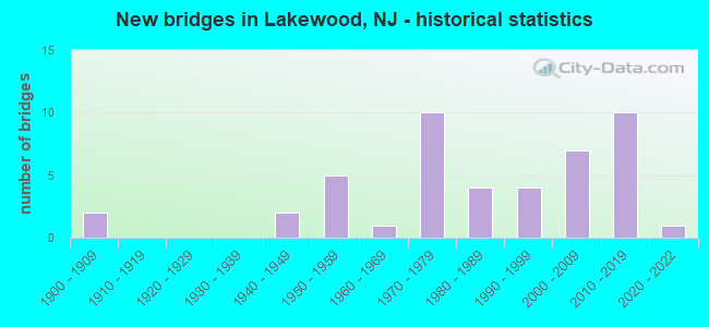
- New bridges - historical statistics
- 21900-1909
- 21940-1949
- 51950-1959
- 11960-1969
- 101970-1979
- 41980-1989
- 41990-1999
- 72000-2009
- 102010-2019
- 12020-2022

- Reconstructed bridges - Historical Statistics
- 11970-1979
- 01980-1989
- 21990-1999
- 22000-2009
- 22010-2019


- Bridge Condition - Deck
- 14.3%Very good
- 42.9%Good
- 35.7%Satisfactory
- 3.6%Fair
- 3.6%Poor

- Bridge Condition - Superstructure
- 6.5%Excellent
- 22.6%Very good
- 41.9%Good
- 16.1%Satisfactory
- 9.7%Fair
- 3.2%Poor

- Bridge Condition - Substructure
- 3.2%Excellent
- 9.7%Very good
- 54.8%Good
- 12.9%Satisfactory
- 9.7%Fair
- 9.7%Poor

- Bridge Condition - Channel
- 9.1%Very good
- 31.8%Good
- 50.0%Satisfactory
- 4.5%Fair
- 4.5%Poor
Find on map >> Show street view
Structure Number: 130HL18, Location: 0.2 MILE NORTH OF CR 526 (Lat: 40.111519, Lng: -74.234831), Route carried "on" structure: Other road , Year Built: 2021, Status: Open, Structure Length: 1.49m (4.89ft), Average Daily Traffic: 3,230 (year 2021), Truck Traffic: 1%, Average Future Daily Traffic: 3,865 (year 2041), Design Load: HL 93, Features Intersected: N. BR. METEDECONK RIVER, Facility Carried by Structure: KENT ROAD
Minimum Vertical Clearance: 30+ m (98+ ft), Kilometerpoint: 0.000, Lanes on structure: 2, Owner: County Highway Agency, Approaching Roadway Width: 9.1m (29.9ft), Material/Design: Prestressed concrete, Design/Construction: Box Beam or Girders - Single/Spread, Number Of Spans In Main Unit: 1, Length of Maximum Span: 13.4m (44.0ft), Curb or Sidewalk Widths: Left: 0.0m, Right: 1.8m (5.9ft), Curb-To-Curb Width: 9.1m (29.9ft), Out-to-Out Width: 12.0m (39.4ft)
Condition: Deck: Very good, Superstructure: Excellent, Substructure: Excellent, Channel: Satisfactory, Operating Rating: 54.4 metric tons, Method Used To Determine Operating Rating: Field evaluation and documented engineering judgment, Inventory Rating: 32.7 metric tons, Method Used To Determine Inventory Rating: Field evaluation and documented engineering judgment, Structural Evaluation: Superior to present desirable criteria, Deck Geometry: Meets minimum limits, Waterway Adequacy: Equal to present desirable criteria, Approach Roadway Alignment: Equal to present desirable criteria, Length Of Structure Improvement: 1.40m (4.59ft), Designated Inspection Frequency: Every 24 months, Inspection Date: March 2021, Bridge Improvement Cost: $1,219,000, Roadway Improvement Cost: $183,000, Total Project Cost: $1,608,000 ( Estimate for 2019), Deck Structure Type: Concrete Cast-file-Place, Wearing Surface/Protective System: Wearing Surface: Monolithic Concrete, Deck Protection: Galvanized Reinforcing
Find on map >> Show street view
Structure Number: 130HL2, Location: 1 MILE WEST OF US 9 (Lat: 40.129281, Lng: -74.241969), Route carried "on" structure: City street , Year Built: 1956, Status: Open, Structure Length: 1.37m (4.49ft), Average Daily Traffic: 2,420 (year 2021), Truck Traffic: 1%, Average Future Daily Traffic: 2,895 (year 2041), Design Load: H 20, Features Intersected: N.BRANCH METEDECONK RIVR, Facility Carried by Structure: CHURCH ROAD
Minimum Vertical Clearance: 30+ m (98+ ft), Kilometerpoint: 0.000, Lanes on structure: 2, Owner: County Highway Agency, Approaching Roadway Width: 9.1m (29.9ft), Material/Design: Concrete, Design/Construction: Tee Beam, Number Of Spans In Main Unit: 3, Length of Maximum Span: 4.3m (14.1ft), Curb-To-Curb Width: 9.1m (29.9ft), Out-to-Out Width: 9.3m (30.5ft)
Condition: Deck: Poor, Superstructure: Poor, Substructure: Poor, Channel: Satisfactory, Operating Rating: 42.6 metric tons, Method Used To Determine Operating Rating: Load Factor (LF), Inventory Rating: 25.4 metric tons, Method Used To Determine Inventory Rating: Load Factor (LF), Structural Evaluation: Meets minimum limits, Deck Geometry: Meets minimum limits, Waterway Adequacy: Equal to present desirable criteria, Approach Roadway Alignment: Better than present minimum criteria, Length Of Structure Improvement: 1.85m (6.07ft), Designated Inspection Frequency: Every 24 months, Underwater Inspection Frequency: Every 48 months, Inspection Date: March 2021, Underwater Inspection Date: July 2019, Bridge Improvement Cost: $1,068,000, Roadway Improvement Cost: $160,000, Total Project Cost: $1,831,000 ( Estimate for 2021), Deck Structure Type: Concrete Precast Panels, Wearing Surface/Protective System: Wearing Surface: Bituminous
Find on map >> Show street view
Structure Number: 130HL22, Location: 1.4 MILES WEST OF US 9 (Lat: 40.147631, Lng: -74.253839), Route carried "on" structure: City street , Year Built: 1960, Status: Open, Structure Length: 1.01m (3.31ft), Average Daily Traffic: 9,010 (year 2021), Truck Traffic: 4%, Average Future Daily Traffic: 10,994 (year 2041), Features Intersected: N.BRANCH METEDECONK RIVR, Facility Carried by Structure: ALDRICH ROAD
Minimum Vertical Clearance: 30+ m (98+ ft), Kilometerpoint: 5.086, Lanes on structure: 2, Owner: County Highway Agency, Approaching Roadway Width: 9.8m (32.2ft), Material/Design: Concrete continuous, Design/Construction: Slab, Number Of Spans In Main Unit: 2, Length of Maximum Span: 4.6m (15.1ft), Curb or Sidewalk Widths: Left: 0.0m, Right: 1.2m (3.9ft), Curb-To-Curb Width: 9.7m (31.8ft), Out-to-Out Width: 11.0m (36.1ft)
Condition: Deck: Fair, Superstructure: Fair, Substructure: Fair, Channel: Fair, Operating Rating: 37.2 metric tons, Method Used To Determine Operating Rating: Load Factor (LF), Inventory Rating: 22.7 metric tons, Method Used To Determine Inventory Rating: Load Factor (LF), Structural Evaluation: Somewhat better than minimum adequacy, Deck Geometry: High priority of corrective action, Waterway Adequacy: Equal to present minimum criteria, Approach Roadway Alignment: Equal to present desirable criteria, Length Of Structure Improvement: 1.01m (3.31ft), Designated Inspection Frequency: Every 24 months, Underwater Inspection Frequency: Every 48 months, Inspection Date: June 2021, Underwater Inspection Date: May 2021, Bridge Improvement Cost: $126,000, Roadway Improvement Cost: $62,000, Total Project Cost: $291,000 ( Estimate for 2021), Deck Structure Type: Concrete Precast Panels, Wearing Surface/Protective System: Wearing Surface: Bituminous
Find on map >> Show street view
Structure Number: 130HL53, Location: 0.24mi S. of Oak Glenn Rd (Lat: 40.123919, Lng: -74.188219), Route carried "on" structure: County highway 547, Year Built: 2004, Status: Open, Structure Length: 0.91m (2.99ft), Average Daily Traffic: 12,188 (year 2021), Truck Traffic: 3%, Average Future Daily Traffic: 14,872 (year 2041), Design Load: HS 25 or greater, Features Intersected: HAYSTACK BROOK
Minimum Vertical Clearance: 30+ m (98+ ft), Kilometerpoint: 18.926, Lanes on structure: 2, Owner: County Highway Agency, Approaching Roadway Width: 12.2m (40.0ft), Material/Design: Concrete, Design/Construction: Frame, Number Of Spans In Main Unit: 1, Length of Maximum Span: 9.1m (29.9ft), Curb or Sidewalk Widths: Left: 1.5m (4.9ft), Right: 1.6m (5.2ft), Curb-To-Curb Width: 12.2m (40.0ft), Out-to-Out Width: 15.8m (51.8ft)
Condition: Deck: Very good, Superstructure: Very good, Substructure: Good, Channel: Satisfactory, Operating Rating: 84.4 metric tons, Method Used To Determine Operating Rating: Load Factor (LF), Inventory Rating: 50.8 metric tons, Method Used To Determine Inventory Rating: Load Factor (LF), Structural Evaluation: Better than present minimum criteria, Deck Geometry: Somewhat better than minimum adequacy, Waterway Adequacy: Better than present minimum criteria, Approach Roadway Alignment: Equal to present desirable criteria, Designated Inspection Frequency: Every 24 months, Underwater Inspection Frequency: Every 48 months, Inspection Date: June 2021, Underwater Inspection Date: September 2021, Deck Structure Type: Concrete Cast-file-Place, Wearing Surface/Protective System: Wearing Surface: Bituminous, Deck Protection: Galvanized Reinforcing
Find on map >> Show street view
Structure Number: 130HL61, Location: 2.7MILES W OF CR 549 (Lat: 40.115519, Lng: -74.175461), Route carried "on" structure: City street , Year Built: 1944, Year Reconstructed: 1995, Status: Posted for load, Structure Length: 1.01m (3.31ft), Average Daily Traffic: 6,113 (year 2021), Truck Traffic: 1%, Average Future Daily Traffic: 7,306 (year 2041), Features Intersected: HAYSTACK BROOK, Facility Carried by Structure: LAKEWD-ALLENWD RD
Minimum Vertical Clearance: 30+ m (98+ ft), Kilometerpoint: 0.869, Lanes on structure: 2, Owner: County Highway Agency, Approaching Roadway Width: 7.3m (24.0ft), Material/Design: Wood or Timber, Design/Construction: Stringer/Multi-beam, Number Of Spans In Main Unit: 2, Length of Maximum Span: 4.6m (15.1ft), Curb-To-Curb Width: 7.0m (23.0ft), Out-to-Out Width: 7.3m (24.0ft)
Condition: Deck: Satisfactory, Superstructure: Fair, Substructure: Poor, Channel: Satisfactory, Operating Rating: 26.3 metric tons, Method Used To Determine Operating Rating: Allowable Stress (AS), Inventory Rating: 19.1 metric tons, Method Used To Determine Inventory Rating: Allowable Stress (AS), Structural Evaluation: Meets minimum limits, Deck Geometry: High priority of replacement, Waterway Adequacy: Better than present minimum criteria, Approach Roadway Alignment: Equal to present desirable criteria, Length Of Structure Improvement: 1.62m (5.31ft), Designated Inspection Frequency: Every 24 months, Inspection Date: May 2021, Bridge Improvement Cost: $928,000, Roadway Improvement Cost: $139,000, Total Project Cost: $1,592,000 ( Estimate for 2021), Deck Structure Type: Wood or Timber, Wearing Surface/Protective System: Wearing Surface: Bituminous
Find on map >> Show street view
Structure Number: 130HL62, Location: 0.7 MILE SOUTH OF CR 547 (Lat: 40.116269, Lng: -74.181731), Route carried "on" structure: City street , Year Built: 1946, Year Reconstructed: 1970, Status: Open, Structure Length: 0.98m (3.22ft), Average Daily Traffic: 1,045 (year 2021), Truck Traffic: 3%, Average Future Daily Traffic: 1,250 (year 2041), Features Intersected: HAYSTACK BROOK, Facility Carried by Structure: OAK GLEN ROAD
Minimum Vertical Clearance: 30+ m (98+ ft), Kilometerpoint: 0.338, Lanes on structure: 2, Owner: County Highway Agency, Approaching Roadway Width: 7.3m (24.0ft), Material/Design: Concrete continuous, Design/Construction: Slab, Number Of Spans In Main Unit: 2, Length of Maximum Span: 4.0m (13.1ft), Curb-To-Curb Width: 7.3m (24.0ft), Out-to-Out Width: 7.9m (25.9ft)
Condition: Deck: Satisfactory, Superstructure: Satisfactory, Substructure: Poor, Channel: Satisfactory, Operating Rating: 77.1 metric tons, Method Used To Determine Operating Rating: Load Factor (LF), Inventory Rating: 46.3 metric tons, Method Used To Determine Inventory Rating: Load Factor (LF), Structural Evaluation: Meets minimum limits, Deck Geometry: Meets minimum limits, Waterway Adequacy: Better than present minimum criteria, Approach Roadway Alignment: Better than present minimum criteria, Length Of Structure Improvement: 1.46m (4.79ft), Designated Inspection Frequency: Every 24 months, Inspection Date: March 2021, Bridge Improvement Cost: $844,000, Roadway Improvement Cost: $126,000, Total Project Cost: $1,508,000 ( Estimate for 2021), Deck Structure Type: Concrete Cast-file-Place, Wearing Surface/Protective System: Wearing Surface: Bituminous
Find on map >> Show street view
Structure Number: 130HL7, Location: 0.39 mi S. of Oak Glen Rd (Lat: 40.146239, Lng: -74.199211), Route carried "on" structure: County highway , Year Built: 1984, Status: Open, Structure Length: 0.73m (2.40ft), Average Daily Traffic: 2,957 (year 2021), Truck Traffic: 1%, Average Future Daily Traffic: 3,609 (year 2041), Design Load: HS 20, Features Intersected: HAY STACK BROOK, Facility Carried by Structure: MAXIM SOUTHARD RD
Minimum Vertical Clearance: 30+ m (98+ ft), Kilometerpoint: 0.000, Lanes on structure: 2, Owner: County Highway Agency, Approaching Roadway Width: 10.4m (34.1ft), Material/Design: Concrete, Design/Construction: Culvert, Number Of Spans In Main Unit: 2, Length of Maximum Span: 3.7m (12.1ft), Curb or Sidewalk Widths: Left: 1.5m (4.9ft), Right: 0.0m, Curb-To-Curb Width: 10.5m (34.4ft), Out-to-Out Width: 12.3m (40.4ft)
Condition: Channel: Good, Culverts: Good, Operating Rating: 54.4 metric tons, Method Used To Determine Operating Rating: Field evaluation and documented engineering judgment, Inventory Rating: 32.7 metric tons, Method Used To Determine Inventory Rating: Field evaluation and documented engineering judgment, Structural Evaluation: Better than present minimum criteria, Deck Geometry: Somewhat better than minimum adequacy, Waterway Adequacy: Better than present minimum criteria, Approach Roadway Alignment: Equal to present desirable criteria, Designated Inspection Frequency: Every 24 months, Inspection Date: May 2021, Deck Structure Type: Concrete Cast-file-Place
Find on map >> Show street view
Structure Number: 1333152, Location: 5.8 MILES SOUTH OF RT 33F (Lat: 40.164919, Lng: -74.235439), Route carried "on" structure: Interstate 195, Year Built: 1978, Status: Open, Structure Length: 5.21m (17.09ft), Average Daily Traffic: 23,339 (year 2019), Truck Traffic: 9%, Average Future Daily Traffic: 28,006 (year 2019), Design Load: HS 20+Mod, Features Intersected: U.S.ROUTE 9
Minimum Vertical Clearance: 30+ m (98+ ft), Kilometerpoint: 43.726, Lanes on structure: 3, Lanes under structure: 6, Base Highway Network: Yes, Owner: State Highway Agency, Approaching Roadway Width: 15.8m (51.8ft), Skew: 1 degrees, Material/Design: Steel, Design/Construction: Stringer/Multi-beam, Number Of Spans In Main Unit: 2, Length of Maximum Span: 25.9m (85.0ft), Curb-To-Curb Width: 15.8m (51.8ft), Out-to-Out Width: 17.8m (58.4ft)
Condition: Deck: Satisfactory, Superstructure: Good, Substructure: Good, Operating Rating: 86.2 metric tons, Method Used To Determine Operating Rating: Load Factor (LF), Inventory Rating: 51.7 metric tons, Method Used To Determine Inventory Rating: Load Factor (LF), Structural Evaluation: Better than present minimum criteria, Deck Geometry: Somewhat better than minimum adequacy, Underclear: Better than present minimum criteria, Approach Roadway Alignment: Equal to present desirable criteria, Designated Inspection Frequency: Every 24 months, Inspection Date: July 2021, Deck Structure Type: Concrete Cast-file-Place, Wearing Surface/Protective System: Wearing Surface: Monolithic Concrete, Deck Protection: Epoxy Coated Reinforcing
Find on map >> Show street view
Structure Number: 1333153, Location: 7.0 MI WEST OF RT 34 JCT (Lat: 40.164611, Lng: -74.235281), Route carried "on" structure: Interstate 195, Year Built: 1978, Status: Open, Structure Length: 5.21m (17.09ft), Average Daily Traffic: 23,339 (year 2019), Truck Traffic: 9%, Average Future Daily Traffic: 28,006 (year 2039), Design Load: HS 20+Mod, Features Intersected: ROUTE 9
Minimum Vertical Clearance: 30+ m (98+ ft), Kilometerpoint: 43.726, Lanes on structure: 3, Lanes under structure: 6, Base Highway Network: Yes, Owner: State Highway Agency, Approaching Roadway Width: 15.8m (51.8ft), Skew: 1 degrees, Material/Design: Steel, Design/Construction: Stringer/Multi-beam, Number Of Spans In Main Unit: 2, Length of Maximum Span: 25.9m (85.0ft), Curb-To-Curb Width: 16.0m (52.5ft), Out-to-Out Width: 17.8m (58.4ft)
Condition: Deck: Satisfactory, Superstructure: Good, Substructure: Good, Operating Rating: 88.0 metric tons, Method Used To Determine Operating Rating: Load Factor (LF), Inventory Rating: 52.6 metric tons, Method Used To Determine Inventory Rating: Load Factor (LF), Structural Evaluation: Better than present minimum criteria, Deck Geometry: Equal to present minimum criteria, Underclear: Better than present minimum criteria, Approach Roadway Alignment: Better than present minimum criteria, Designated Inspection Frequency: Every 24 months, Inspection Date: July 2021, Deck Structure Type: Concrete Cast-file-Place, Wearing Surface/Protective System: Wearing Surface: Monolithic Concrete, Deck Protection: Epoxy Coated Reinforcing
Find on map >> Show street view
Structure Number: 1333154, Location: 0.6 MI E OF US RT 9 JCT (Lat: 40.166861, Lng: -74.225169), Route carried "on" structure: Interstate 195, Year Built: 1978, Status: Open, Structure Length: 3.60m (11.81ft), Average Daily Traffic: 26,200 (year 2020), Truck Traffic: 9%, Average Future Daily Traffic: 31,000 (year 2040), Design Load: HS 20, Features Intersected: PINEWOOD RD
Minimum Vertical Clearance: 30.45m (99.90ft), Kilometerpoint: 44.659, Lanes on structure: 2, Lanes under structure: 2, Base Highway Network: Yes, Owner: State Highway Agency, Approaching Roadway Width: 12.8m (42.0ft), Material/Design: Steel, Design/Construction: Stringer/Multi-beam, Number Of Spans In Main Unit: 1, Length of Maximum Span: 34.7m (113.8ft), Curb-To-Curb Width: 13.0m (42.7ft), Out-to-Out Width: 14.8m (48.6ft)
Condition: Deck: Satisfactory, Superstructure: Very good, Substructure: Good, Operating Rating: 89.8 metric tons, Method Used To Determine Operating Rating: Load Factor (LF), Inventory Rating: 57.2 metric tons, Method Used To Determine Inventory Rating: Load Factor (LF), Structural Evaluation: Better than present minimum criteria, Deck Geometry: Superior to present desirable criteria, Underclear: Equal to present minimum criteria, Approach Roadway Alignment: Equal to present desirable criteria, Designated Inspection Frequency: Every 24 months, Inspection Date: May 2020, Deck Structure Type: Concrete Cast-file-Place, Wearing Surface/Protective System: Wearing Surface: Monolithic Concrete
Find on map >> Show street view
Structure Number: 1333155, Location: 0.6 MI E OF US RT 9 JCT (Lat: 40.166581, Lng: -74.225219), Route carried "on" structure: Interstate 195, Year Built: 1978, Status: Open, Structure Length: 3.60m (11.81ft), Average Daily Traffic: 27,540 (year 2020), Truck Traffic: 9%, Average Future Daily Traffic: 33,610 (year 2040), Design Load: HS 20, Features Intersected: PINEWOOD ROAD
Minimum Vertical Clearance: 30+ m (98+ ft), Kilometerpoint: 44.659, Lanes on structure: 2, Lanes under structure: 2, Base Highway Network: Yes, Owner: State Highway Agency, Approaching Roadway Width: 13.1m (43.0ft), Material/Design: Steel, Design/Construction: Stringer/Multi-beam, Number Of Spans In Main Unit: 1, Length of Maximum Span: 34.7m (113.8ft), Curb-To-Curb Width: 13.1m (43.0ft), Out-to-Out Width: 14.8m (48.6ft)
Condition: Deck: Good, Superstructure: Good, Substructure: Good, Inventory Rating: 57.2 metric tons, Method Used To Determine Inventory Rating: Load Factor (LF), Structural Evaluation: Better than present minimum criteria, Deck Geometry: Superior to present desirable criteria, Underclear: Superior to present desirable criteria, Approach Roadway Alignment: Equal to present desirable criteria, Designated Inspection Frequency: Every 24 months, Inspection Date: August 2020, Deck Structure Type: Concrete Cast-file-Place, Wearing Surface/Protective System: Wearing Surface: Monolithic Concrete, Deck Protection: Epoxy Coated Reinforcing
Find on map >> Show street view
Structure Number: 1504151, Location: 0.3 MI S OF RT 88 JCT (Lat: 40.085461, Lng: -74.215381), Route carried "on" structure: US 9, Year Built: 1908, Status: Open, Structure Length: 1.16m (3.81ft), Average Daily Traffic: 28,415 (year 2020), Truck Traffic: 4%, Average Future Daily Traffic: 34,706 (year 2040), Features Intersected: WATERING PLACE BROOK
Minimum Vertical Clearance: 30+ m (98+ ft), Kilometerpoint: 163.187, Lanes on structure: 2, Base Highway Network: Yes, Owner: State Highway Agency, Approaching Roadway Width: 11.0m (36.1ft), Material/Design: Concrete, Design/Construction: Arch - Deck, Number Of Spans In Main Unit: 2, Length of Maximum Span: 5.2m (17.1ft), Curb or Sidewalk Widths: Left: 1.5m (4.9ft), Right: 1.6m (5.2ft), Curb-To-Curb Width: 10.9m (35.8ft), Out-to-Out Width: 14.7m (48.2ft)
Condition: Superstructure: Fair, Substructure: Fair, Channel: Poor, Operating Rating: 56.2 metric tons, Method Used To Determine Operating Rating: Load Factor (LF), Inventory Rating: 33.6 metric tons, Method Used To Determine Inventory Rating: Load Factor (LF), Structural Evaluation: Somewhat better than minimum adequacy, Deck Geometry: Meets minimum limits, Waterway Adequacy: Equal to present desirable criteria, Approach Roadway Alignment: Better than present minimum criteria, Designated Inspection Frequency: Every 24 months, Underwater Inspection Frequency: Every 48 months, Inspection Date: September 2020, Underwater Inspection Date: December 2020
Find on map >> Show street view
Structure Number: 1504152, Location: 1.5 MI NO OF SR 88 (Lat: 40.109981, Lng: -74.218989), Route carried "on" structure: US 9, Year Built: 1986, Status: Open, Structure Length: 1.68m (5.51ft), Average Daily Traffic: 50,922 (year 2021), Truck Traffic: 4%, Average Future Daily Traffic: 61,107 (year 2041), Design Load: HS 20, Features Intersected: N BR METEDECONK RIVER
Minimum Vertical Clearance: 30+ m (98+ ft), Kilometerpoint: 165.972, Lanes on structure: 4, Base Highway Network: Yes, Owner: State Highway Agency, Approaching Roadway Width: 21.9m (71.9ft), Material/Design: Prestressed concrete, Design/Construction: Box Beam or Girders - Multiple, Number Of Spans In Main Unit: 1, Length of Maximum Span: 15.5m (50.9ft), Curb or Sidewalk Widths: Left: 1.8m (5.9ft), Right: 1.8m (5.9ft), Curb-To-Curb Width: 21.9m (71.9ft), Out-to-Out Width: 26.3m (86.3ft)
Condition: Deck: Good, Superstructure: Good, Substructure: Very good, Channel: Good, Operating Rating: 87.1 metric tons, Method Used To Determine Operating Rating: Load Factor (LF), Inventory Rating: 33.6 metric tons, Method Used To Determine Inventory Rating: Load Factor (LF), Structural Evaluation: Better than present minimum criteria, Deck Geometry: Superior to present desirable criteria, Waterway Adequacy: Equal to present minimum criteria, Approach Roadway Alignment: Equal to present desirable criteria, Designated Inspection Frequency: Every 24 months, Inspection Date: October 2021, Deck Structure Type: Concrete Cast-file-Place, Wearing Surface/Protective System: Wearing Surface: Monolithic Concrete, Deck Protection: Epoxy Coated Reinforcing
Find on map >> Show street view
Structure Number: 1511005, Location: 5MI SE INTER I-195 & 9 (Lat: 40.116350, Lng: -74.265581), Route carried "on" structure: City street , Year Built: 1974, Status: Open, Structure Length: 1.37m (4.49ft), Average Daily Traffic: 8,995 (year 2020), Truck Traffic: 1%, Average Future Daily Traffic: 10,794 (year 2040), Design Load: HS 20, Features Intersected: SO. BRANCH METEDECONK R., Facility Carried by Structure: BREWERS BRIDGE RD
Minimum Vertical Clearance: 30+ m (98+ ft), Kilometerpoint: 2.784, Lanes on structure: 2, Owner: County Highway Agency, Approaching Roadway Width: 12.2m (40.0ft), Skew: 1 degrees, Material/Design: Prestressed concrete, Design/Construction: Slab, Number Of Spans In Main Unit: 1, Length of Maximum Span: 12.5m (41.0ft), Curb or Sidewalk Widths: Left: 1.2m (3.9ft), Right: 1.2m (3.9ft), Curb-To-Curb Width: 12.2m (40.0ft), Out-to-Out Width: 15.4m (50.5ft)
Condition: Deck: Satisfactory, Superstructure: Satisfactory, Substructure: Satisfactory, Channel: Satisfactory, Operating Rating: 56.2 metric tons, Method Used To Determine Operating Rating: Load Factor (LF), Inventory Rating: 33.6 metric tons, Method Used To Determine Inventory Rating: Load Factor (LF), Structural Evaluation: Equal to present minimum criteria, Deck Geometry: Somewhat better than minimum adequacy, Waterway Adequacy: Equal to present desirable criteria, Approach Roadway Alignment: Better than present minimum criteria, Designated Inspection Frequency: Every 24 months, Inspection Date: March 2020, Deck Structure Type: Concrete Precast Panels, Wearing Surface/Protective System: Wearing Surface: Bituminous, Membrane: Preformed Fabric
Find on map >> Show street view
Structure Number: 1514001, Location: .6 MI N OF RT 526 (Lat: 40.106919, Lng: -74.164061), Route carried "on" structure: County highway , Year Built: 1990, Status: Open, Structure Length: 1.31m (4.30ft), Average Daily Traffic: 6,627 (year 2020), Truck Traffic: 1%, Average Future Daily Traffic: 7,952 (year 2040), Design Load: HS 20+Mod, Features Intersected: NO BRCH METEDECONK RIVER, Facility Carried by Structure: RIDGE AVE
Minimum Vertical Clearance: 30+ m (98+ ft), Kilometerpoint: 0.966, Lanes on structure: 2, Owner: County Highway Agency, Approaching Roadway Width: 10.1m (33.1ft), Skew: 1 degrees, Material/Design: Prestressed concrete, Design/Construction: Slab, Number Of Spans In Main Unit: 1, Length of Maximum Span: 12.2m (40.0ft), Curb or Sidewalk Widths: Left: 0.4m (1.3ft), Right: 1.2m (3.9ft), Curb-To-Curb Width: 15.2m (49.9ft), Out-to-Out Width: 17.6m (57.7ft)
Condition: Deck: Satisfactory, Superstructure: Satisfactory, Substructure: Good, Channel: Good, Operating Rating: 54.4 metric tons, Method Used To Determine Operating Rating: Load Factor (LF), Inventory Rating: 32.7 metric tons, Method Used To Determine Inventory Rating: Load Factor (LF), Structural Evaluation: Equal to present minimum criteria, Deck Geometry: Superior to present desirable criteria, Waterway Adequacy: Superior to present desirable criteria, Approach Roadway Alignment: Better than present minimum criteria, Designated Inspection Frequency: Every 24 months, Underwater Inspection Frequency: Every 48 months, Inspection Date: April 2020, Underwater Inspection Date: April 2020, Deck Structure Type: Concrete Precast Panels, Wearing Surface/Protective System: Wearing Surface: Bituminous, Membrane: Preformed Fabric, Deck Protection: Epoxy Coated Reinforcing
Find on map >> Show street view
Structure Number: 1514002, Location: 0.5 MI. N. OF CR 526 (Lat: 40.110419, Lng: -74.180639), Route carried "on" structure: County highway , Year Built: 2012, Status: Open, Structure Length: 1.80m (5.91ft), Average Daily Traffic: 8,476 (year 2020), Truck Traffic: 3%, Average Future Daily Traffic: 10,171 (year 2040), Design Load: HS 25 or greater, Features Intersected: NO BR.METEDECONK RIVER, Facility Carried by Structure: BROOK ROAD
Minimum Vertical Clearance: 30+ m (98+ ft), Kilometerpoint: 1.625, Lanes on structure: 2, Owner: County Highway Agency, Approaching Roadway Width: 12.2m (40.0ft), Skew: 1 degrees, Material/Design: Prestressed concrete, Design/Construction: Slab, Number Of Spans In Main Unit: 2, Length of Maximum Span: 8.5m (27.9ft), Curb-To-Curb Width: 12.2m (40.0ft), Out-to-Out Width: 13.5m (44.3ft)
Condition: Deck: Good, Superstructure: Good, Substructure: Good, Channel: Satisfactory, Operating Rating: 84.4 metric tons, Method Used To Determine Operating Rating: Load Factor (LF), Inventory Rating: 50.8 metric tons, Method Used To Determine Inventory Rating: Load Factor (LF), Structural Evaluation: Better than present minimum criteria, Deck Geometry: Somewhat better than minimum adequacy, Waterway Adequacy: Equal to present minimum criteria, Approach Roadway Alignment: Equal to present minimum criteria, Designated Inspection Frequency: Every 24 months, Inspection Date: May 2020, Deck Structure Type: Concrete Cast-file-Place, Wearing Surface/Protective System: Wearing Surface: Latex Concrete, Deck Protection: Epoxy Coated Reinforcing
Find on map >> Show street view
Structure Number: 1514003, Location: 0.6 MI N OF RT 526 (Lat: 40.111681, Lng: -74.199269), Route carried "on" structure: County highway 547, Year Built: 1994, Status: Open, Structure Length: 2.19m (7.19ft), Average Daily Traffic: 8,955 (year 2020), Truck Traffic: 3%, Average Future Daily Traffic: 10,925 (year 2040), Design Load: HS 20+Mod, Features Intersected: NO BRANCH METEDECONK RIV
Minimum Vertical Clearance: 30+ m (98+ ft), Kilometerpoint: 17.268, Lanes on structure: 2, Owner: County Highway Agency, Approaching Roadway Width: 12.2m (40.0ft), Skew: 1 degrees, Material/Design: Prestressed concrete, Design/Construction: Box Beam or Girders - Multiple, Number Of Spans In Main Unit: 1, Length of Maximum Span: 20.4m (66.9ft), Curb or Sidewalk Widths: Left: 1.2m (3.9ft), Right: 0.3m (1.0ft), Curb-To-Curb Width: 15.1m (49.5ft), Out-to-Out Width: 17.2m (56.4ft)
Condition: Deck: Satisfactory, Superstructure: Very good, Substructure: Good, Channel: Satisfactory, Operating Rating: 75.3 metric tons, Method Used To Determine Operating Rating: Load Factor (LF), Inventory Rating: 45.4 metric tons, Method Used To Determine Inventory Rating: Load Factor (LF), Structural Evaluation: Better than present minimum criteria, Deck Geometry: Superior to present desirable criteria, Waterway Adequacy: Superior to present desirable criteria, Approach Roadway Alignment: Equal to present desirable criteria, Designated Inspection Frequency: Every 24 months, Inspection Date: April 2020, Deck Structure Type: Concrete Cast-file-Place, Wearing Surface/Protective System: Wearing Surface: Monolithic Concrete, Deck Protection: Epoxy Coated Reinforcing
Find on map >> Show street view
Structure Number: 1514005, Location: 1 MI E OF US 9 & RT 528 (Lat: 40.087211, Lng: -74.200481), Route carried "on" structure: County highway , Year Built: 1989, Status: Open, Structure Length: 1.16m (3.81ft), Average Daily Traffic: 2,250 (year 2020), Truck Traffic: 3%, Average Future Daily Traffic: 2,745 (year 2040), Design Load: HS 20+Mod, Features Intersected: SO BRCH METEDECONK RIVER, Facility Carried by Structure: CLOVER ST.
Minimum Vertical Clearance: 30+ m (98+ ft), Kilometerpoint: 0.515, Lanes on structure: 2, Owner: County Highway Agency, Approaching Roadway Width: 12.2m (40.0ft), Material/Design: Wood or Timber, Design/Construction: Slab, Number Of Spans In Main Unit: 2, Length of Maximum Span: 5.8m (19.0ft), Curb or Sidewalk Widths: Left: 1.3m (4.3ft), Right: 1.2m (3.9ft), Curb-To-Curb Width: 12.2m (40.0ft), Out-to-Out Width: 15.5m (50.9ft)
Condition: Deck: Good, Superstructure: Good, Substructure: Good, Channel: Satisfactory, Structural Evaluation: Better than present minimum criteria, Deck Geometry: Equal to present minimum criteria, Waterway Adequacy: Superior to present desirable criteria, Approach Roadway Alignment: Equal to present desirable criteria, Designated Inspection Frequency: Every 24 months, Underwater Inspection Frequency: Every 48 months, Inspection Date: April 2020, Underwater Inspection Date: May 2018, Deck Structure Type: Wood or Timber, Wearing Surface/Protective System: Wearing Surface: Bituminous, Membrane: Other
Find on map >> Show street view
Structure Number: 1514006, Location: 0.25 MI. EAST OF US 9 (Lat: 40.086989, Lng: -74.212239), Route carried "on" structure: County highway 528, Year Built: 2003, Status: Open, Structure Length: 1.80m (5.91ft), Average Daily Traffic: 28,150 (year 2020), Truck Traffic: 4%, Average Future Daily Traffic: 34,350 (year 2040), Design Load: HS 20+Mod, Features Intersected: S Br Metedeconk River
Minimum Vertical Clearance: 30+ m (98+ ft), Kilometerpoint: 49.053, Lanes on structure: 4, Base Highway Network: Yes, Owner: County Highway Agency, Approaching Roadway Width: 19.2m (63.0ft), Material/Design: Prestressed concrete, Design/Construction: Stringer/Multi-beam, Number Of Spans In Main Unit: 1, Length of Maximum Span: 17.1m (56.1ft), Curb or Sidewalk Widths: Left: 1.4m (4.6ft), Right: 1.4m (4.6ft), Curb-To-Curb Width: 19.2m (63.0ft), Out-to-Out Width: 22.6m (74.1ft)
Condition: Deck: Good, Superstructure: Very good, Substructure: Good, Channel: Satisfactory, Operating Rating: 80.7 metric tons, Method Used To Determine Operating Rating: Load Factor (LF), Inventory Rating: 48.1 metric tons, Method Used To Determine Inventory Rating: Load Factor (LF), Structural Evaluation: Better than present minimum criteria, Deck Geometry: Equal to present minimum criteria, Waterway Adequacy: Equal to present desirable criteria, Approach Roadway Alignment: Equal to present desirable criteria, Designated Inspection Frequency: Every 24 months, Inspection Date: April 2020, Deck Structure Type: Concrete Cast-file-Place, Wearing Surface/Protective System: Wearing Surface: Monolithic Concrete, Deck Protection: Galvanized Reinforcing
Find on map >> Show street view
Structure Number: 1514007, Location: NEAR INTERSECTION OF US 9 (Lat: 40.086311, Lng: -74.215700), Route carried "on" structure: County highway 528, Year Built: 1987, Status: Posted for load, Structure Length: 1.16m (3.81ft), Average Daily Traffic: 13,345 (year 2020), Truck Traffic: 4%, Average Future Daily Traffic: 16,280 (year 2040), Design Load: HS 20+Mod, Features Intersected: CARASALJO LAKE
Minimum Vertical Clearance: 30+ m (98+ ft), Kilometerpoint: 48.650, Lanes on structure: 4, Owner: County Highway Agency, Approaching Roadway Width: 15.2m (49.9ft), Material/Design: Concrete, Design/Construction: Arch - Deck, Number Of Spans In Main Unit: 1, Length of Maximum Span: 11.6m (38.1ft), Curb or Sidewalk Widths: Left: 1.6m (5.2ft), Right: 1.6m (5.2ft), Curb-To-Curb Width: 15.2m (49.9ft), Out-to-Out Width: 22.6m (74.1ft)
Condition: Superstructure: Good, Substructure: Good, Channel: Very good, Operating Rating: 43.5 metric tons, Method Used To Determine Operating Rating: Load Factor (LF), Inventory Rating: 26.3 metric tons, Method Used To Determine Inventory Rating: Load Factor (LF), Structural Evaluation: Equal to present minimum criteria, Deck Geometry: High priority of corrective action, Waterway Adequacy: Superior to present desirable criteria, Approach Roadway Alignment: Equal to present desirable criteria, Designated Inspection Frequency: Every 24 months, Underwater Inspection Frequency: Every 48 months, Inspection Date: April 2020, Underwater Inspection Date: July 2020
Find on map >> Show street view
Structure Number: 1514009, Location: 0.78 MI W OF US 9 (Lat: 40.094800, Lng: -74.227881), Route carried "on" structure: City street , Year Built: 1900, Year Reconstructed: 1998, Status: Posted for load, Structure Length: 1.40m (4.59ft), Average Daily Traffic: 4,145 (year 2020), Truck Traffic: 3%, Average Future Daily Traffic: 5,055 (year 2040), Design Load: H 20, Features Intersected: Arm of Lake Carasaljo, Facility Carried by Structure: North Lake Drive
Minimum Vertical Clearance: 30+ m (98+ ft), Kilometerpoint: 1.239, Lanes on structure: 2, Owner: County Highway Agency, Approaching Roadway Width: 6.7m (22.0ft), Material/Design: Masonry, Design/Construction: Arch - Deck, Number Of Spans In Main Unit: 1, Length of Maximum Span: 14.0m (45.9ft), Curb or Sidewalk Widths: Left: 1.3m (4.3ft), Right: 0.9m (3.0ft), Curb-To-Curb Width: 6.7m (22.0ft), Out-to-Out Width: 10.2m (33.5ft)
Condition: Superstructure: Satisfactory, Substructure: Good, Channel: Good, Operating Rating: 31.8 metric tons, Method Used To Determine Operating Rating: Field evaluation and documented engineering judgment, Inventory Rating: 19.1 metric tons, Method Used To Determine Inventory Rating: Field evaluation and documented engineering judgment, Structural Evaluation: Somewhat better than minimum adequacy, Deck Geometry: High priority of replacement, Waterway Adequacy: Superior to present desirable criteria, Approach Roadway Alignment: Equal to present desirable criteria, Length Of Structure Improvement: 1.40m (4.59ft), Designated Inspection Frequency: Every 24 months, Inspection Date: April 2020, Bridge Improvement Cost: $4,000, Roadway Improvement Cost: $49,000, Total Project Cost: $260,000 ( Estimate for 2020)
Find on map >> Show street view
Structure Number: 151401, Location: 0.6 MI SOUTH CO. RT. 526 (Lat: 40.103711, Lng: -74.244831), Route carried "on" structure: County highway 639, Year Built: 1990, Status: Open, Structure Length: 1.01m (3.31ft), Average Daily Traffic: 19,090 (year 2020), Truck Traffic: 4%, Average Future Daily Traffic: 23,290 (year 2040), Design Load: HS 20+Mod, Features Intersected: S. BR. METEDECONK RIVER
Minimum Vertical Clearance: 30+ m (98+ ft), Kilometerpoint: 3.154, Lanes on structure: 4, Owner: County Highway Agency, Approaching Roadway Width: 15.2m (49.9ft), Material/Design: Prestressed concrete, Design/Construction: Slab, Number Of Spans In Main Unit: 1, Length of Maximum Span: 9.1m (29.9ft), Curb or Sidewalk Widths: Left: 1.5m (4.9ft), Right: 1.5m (4.9ft), Curb-To-Curb Width: 15.2m (49.9ft), Out-to-Out Width: 18.9m (62.0ft)
Condition: Deck: Satisfactory, Superstructure: Satisfactory, Substructure: Good, Channel: Satisfactory, Operating Rating: 89.8 metric tons, Method Used To Determine Operating Rating: Load Factor (LF), Inventory Rating: 89.8 metric tons, Method Used To Determine Inventory Rating: Load Factor (LF), Structural Evaluation: Equal to present minimum criteria, Deck Geometry: High priority of corrective action, Waterway Adequacy: Superior to present desirable criteria, Approach Roadway Alignment: Equal to present desirable criteria, Designated Inspection Frequency: Every 24 months, Underwater Inspection Frequency: Every 48 months, Inspection Date: April 2020, Underwater Inspection Date: August 2020, Deck Structure Type: Concrete Cast-file-Place, Wearing Surface/Protective System: Wearing Surface: Monolithic Concrete, Deck Protection: Epoxy Coated Reinforcing
Find on map >> Show street view
Structure Number: 1514011, Location: 0.2 MI SOUTH OF NJ 88 (Lat: 40.082931, Lng: -74.179539), Route carried "on" structure: County highway 623, Year Built: 1994, Status: Open, Structure Length: 2.44m (8.01ft), Average Daily Traffic: 25,145 (year 2020), Truck Traffic: 4%, Average Future Daily Traffic: 30,680 (year 2040), Design Load: HS 25 or greater, Features Intersected: SO BRCH METEDECONK RIVER
Minimum Vertical Clearance: 30+ m (98+ ft), Kilometerpoint: 13.728, Lanes on structure: 4, Base Highway Network: Yes, Owner: County Highway Agency, Approaching Roadway Width: 20.1m (65.9ft), Material/Design: Prestressed concrete, Design/Construction: Stringer/Multi-beam, Number Of Spans In Main Unit: 1, Length of Maximum Span: 22.9m (75.1ft), Curb-To-Curb Width: 20.2m (66.3ft), Out-to-Out Width: 21.2m (69.6ft)
Condition: Deck: Satisfactory, Superstructure: Very good, Substructure: Satisfactory, Channel: Good, Inventory Rating: 59.0 metric tons, Method Used To Determine Inventory Rating: Load Factor (LF), Structural Evaluation: Equal to present minimum criteria, Deck Geometry: Better than present minimum criteria, Waterway Adequacy: Superior to present desirable criteria, Approach Roadway Alignment: Equal to present desirable criteria, Designated Inspection Frequency: Every 24 months, Inspection Date: April 2020, Deck Structure Type: Concrete Cast-file-Place, Wearing Surface/Protective System: Wearing Surface: Monolithic Concrete, Deck Protection: Epoxy Coated Reinforcing
Find on map >> Show street view
Structure Number: 1514012, Location: 1MI W EXIT 90 GSP (Lat: 40.085850, Lng: -74.185031), Route carried "on" structure: City street , Year Built: 1973, Year Reconstructed: 2006, Status: Posted for load, Structure Length: 1.52m (4.99ft), Average Daily Traffic: 105 (year 2020), Truck Traffic: 1%, Average Future Daily Traffic: 126 (year 2040), Design Load: H 10, Features Intersected: SHENANDOAH SPILLWAY, Facility Carried by Structure: PARK ROAD
Minimum Vertical Clearance: 30+ m (98+ ft), Kilometerpoint: 0.000, Lanes on structure: 1, Owner: County Highway Agency, Approaching Roadway Width: 5.5m (18.0ft), Material/Design: Wood or Timber, Design/Construction: Stringer/Multi-beam, Number Of Spans In Main Unit: 1, Length of Maximum Span: 14.6m (47.9ft), Curb or Sidewalk Widths: Left: 1.5m (4.9ft), Right: 1.5m (4.9ft), Curb-To-Curb Width: 4.0m (13.1ft), Out-to-Out Width: 7.0m (23.0ft)
Condition: Deck: Good, Superstructure: Good, Substructure: Fair, Channel: Good, Operating Rating: 26.3 metric tons, Method Used To Determine Operating Rating: Allowable Stress (AS), Inventory Rating: 16.3 metric tons, Method Used To Determine Inventory Rating: Allowable Stress (AS), Structural Evaluation: Somewhat better than minimum adequacy, Deck Geometry: High priority of replacement, Waterway Adequacy: Superior to present desirable criteria, Approach Roadway Alignment: Better than present minimum criteria, Bridge Posting: Required (Relationship of Operating Rating to Maximum Legal Load: 0.1 - 9.9% below), Length Of Structure Improvement: 1.52m (4.99ft), Designated Inspection Frequency: Every 24 months, Underwater Inspection Frequency: Every 48 months, Other Special Inspection Frequency: Every 12 months, Inspection Date: April 2020, Underwater Inspection Date: April 2020, Other Special Inspection Date: April 2021, Bridge Improvement Cost: $190,000, Roadway Improvement Cost: $19,000, Total Project Cost: $304,000 ( Estimate for 2020), Deck Structure Type: Wood or Timber, Wearing Surface/Protective System: Wearing Surface: Bituminous
Find on map >> Show street view
Structure Number: 360893A, Location: At Interchange 88 (Lat: 40.054236, Lng: -74.169194), Route carried "on" structure: ServiceOther road GSP, Year Built: 2014, Status: Open, Structure Length: 7.28m (23.88ft), Average Daily Traffic: 65,200 (year 2021), Truck Traffic: 3%, Average Future Daily Traffic: 79,544 (year 2041), Design Load: HL 93, Features Intersected: NJ Rte 70
Minimum Vertical Clearance: 30+ m (98+ ft), Kilometerpoint: 143.875, Lanes on structure: 3, Lanes under structure: 7, Base Highway Network: Yes, Toll: On toll road, Owner: State Toll Authority, Approaching Roadway Width: 16.8m (55.1ft), Skew: 4 degrees, Material/Design: Steel continuous, Design/Construction: Stringer/Multi-beam, Number Of Spans In Main Unit: 2, Length of Maximum Span: 35.7m (117.1ft), Curb-To-Curb Width: 16.8m (55.1ft), Out-to-Out Width: 17.9m (58.7ft)
Condition: Deck: Very good, Superstructure: Very good, Substructure: Very good, Operating Rating: 45.7 metric tons, Method Used To Determine Operating Rating: Load and Resistance Factor Rating (LRFR) rating reported by rating factor(RF) method using HL-93 loadings, Inventory Rating: 35.3 metric tons, Method Used To Determine Inventory Rating: Load and Resistance Factor Rating (LRFR) rating reported by rating factor(RF) method using HL-93 loadings, Structural Evaluation: Equal to present desirable criteria, Deck Geometry: Equal to present minimum criteria, Underclear: Better than present minimum criteria, Approach Roadway Alignment: Equal to present desirable criteria, Designated Inspection Frequency: Every 24 months, Inspection Date: Febuary 2021, Deck Structure Type: Concrete Cast-file-Place, Wearing Surface/Protective System: Wearing Surface: Monolithic Concrete, Deck Protection: Epoxy Coated Reinforcing
Find on map >> Show street view
Structure Number: 360894A, Location: At Interchange 88 (Lat: 40.054450, Lng: -74.167622), Route carried "on" structure: ServiceOther road GSP, Year Built: 2014, Status: Open, Structure Length: 7.13m (23.39ft), Average Daily Traffic: 64,800 (year 2021), Truck Traffic: 3%, Average Future Daily Traffic: 79,100 (year 2041), Design Load: HL 93, Features Intersected: NJ Rte 70
Minimum Vertical Clearance: 30+ m (98+ ft), Kilometerpoint: 143.875, Lanes on structure: 3, Lanes under structure: 7, Base Highway Network: Yes, Toll: On toll road, Owner: State Toll Authority, Approaching Roadway Width: 16.8m (55.1ft), Skew: 4 degrees, Material/Design: Steel continuous, Design/Construction: Stringer/Multi-beam, Number Of Spans In Main Unit: 2, Length of Maximum Span: 34.7m (113.8ft), Curb-To-Curb Width: 16.8m (55.1ft), Out-to-Out Width: 17.9m (58.7ft)
Condition: Deck: Good, Superstructure: Very good, Substructure: Very good, Operating Rating: 50.5 metric tons, Method Used To Determine Operating Rating: Load and Resistance Factor Rating (LRFR) rating reported by rating factor(RF) method using HL-93 loadings, Inventory Rating: 38.9 metric tons, Method Used To Determine Inventory Rating: Load and Resistance Factor Rating (LRFR) rating reported by rating factor(RF) method using HL-93 loadings, Structural Evaluation: Equal to present desirable criteria, Deck Geometry: Equal to present minimum criteria, Underclear: Better than present minimum criteria, Approach Roadway Alignment: Equal to present desirable criteria, Designated Inspection Frequency: Every 24 months, Inspection Date: Febuary 2021, Deck Structure Type: Concrete Cast-file-Place, Wearing Surface/Protective System: Wearing Surface: Monolithic Concrete, Deck Protection: Epoxy Coated Reinforcing
Find on map >> Show street view
Structure Number: 360902A, Location: 0.8 Mi N of NJ Rt 70 (Lat: 40.065631, Lng: -74.168411), Route carried "on" structure: Ramp Other road GSP, Year Built: 2001, Year Reconstructed: 2012, Status: Open, Structure Length: 0.64m (2.10ft), Average Daily Traffic: 1,750 (year 2021), Truck Traffic: 3%, Average Future Daily Traffic: 2,135 (year 2041), Features Intersected: Cedar Bridge Branch, Facility Carried by Structure: Parkway Ramps 89C
Minimum Vertical Clearance: 30+ m (98+ ft), Kilometerpoint: 145.163, Lanes on structure: 3, Toll: On toll road, Owner: State Toll Authority, Approaching Roadway Width: 16.4m (53.8ft), Skew: 20 degrees, Material/Design: Concrete, Design/Construction: Culvert, Number Of Spans In Main Unit: 4, Length of Maximum Span: 6.4m (21.0ft)
Condition: Channel: Good, Culverts: Good, Structural Evaluation: Better than present minimum criteria, Waterway Adequacy: Equal to present desirable criteria, Approach Roadway Alignment: Equal to present desirable criteria, Designated Inspection Frequency: Every 24 months, Inspection Date: June 2021
Find on map >> Show street view
Structure Number: 360902T, Location: 1 MI N OF RT70&GSP JCT (Lat: 40.065931, Lng: -74.162675), Route carried "on" structure: County highway 528, Year Built: 2003, Status: Open, Structure Length: 10.67m (35.01ft), Average Daily Traffic: 21,939 (year 2021), Truck Traffic: 10%, Average Future Daily Traffic: 26,770 (year 2041), Design Load: HS 25 or greater, Features Intersected: GSP
Minimum Vertical Clearance: 30+ m (98+ ft), Kilometerpoint: 53.945, Lanes on structure: 4, Lanes under structure: 10, Base Highway Network: Yes, Owner: State Toll Authority, Approaching Roadway Width: 17.1m (56.1ft), Skew: 1 degrees, Material/Design: Steel continuous, Design/Construction: Stringer/Multi-beam, Number Of Spans In Main Unit: 4, Length of Maximum Span: 29.3m (96.1ft), Curb or Sidewalk Widths: Left: 0.0m, Right: 1.8m (5.9ft), Curb-To-Curb Width: 17.1m (56.1ft), Out-to-Out Width: 19.8m (65.0ft)
Condition: Deck: Good, Superstructure: Good, Substructure: Good, Operating Rating: 61.6 metric tons, Method Used To Determine Operating Rating: Load and Resistance Factor Rating (LRFR) rating reported by rating factor(RF) method using HL-93 loadings, Inventory Rating: 47.6 metric tons, Method Used To Determine Inventory Rating: Load and Resistance Factor Rating (LRFR) rating reported by rating factor(RF) method using HL-93 loadings, Structural Evaluation: Better than present minimum criteria, Deck Geometry: Somewhat better than minimum adequacy, Underclear: High priority of corrective action, Approach Roadway Alignment: Equal to present desirable criteria, Designated Inspection Frequency: Every 24 months, Inspection Date: Febuary 2021, Deck Structure Type: Concrete Cast-file-Place, Wearing Surface/Protective System: Wearing Surface: Monolithic Concrete, Deck Protection: Epoxy Coated Reinforcing
Find on map >> Show street view
Structure Number: 360914N, Location: 1.5 MI NW OF RT70&88 CIR (Lat: 40.081544, Lng: -74.154158), Route carried "on" structure: Other road GSP, Year Built: 1954, Year Reconstructed: 2015, Status: Open, Structure Length: 2.83m (9.28ft), Average Daily Traffic: 58,350 (year 2021), Truck Traffic: 3%, Average Future Daily Traffic: 71,190 (year 2041), Design Load: HL 93, Features Intersected: NJ Route 88 (Ocean Ave.)
Minimum Vertical Clearance: 30+ m (98+ ft), Kilometerpoint: 147.046, Lanes on structure: 3, Lanes under structure: 2, Base Highway Network: Yes, Toll: On toll road, Owner: State Toll Authority, Approaching Roadway Width: 18.9m (62.0ft), Skew: 1 degrees, Material/Design: Steel, Design/Construction: Stringer/Multi-beam, Number Of Spans In Main Unit: 1, Length of Maximum Span: 18.9m (62.0ft), Curb-To-Curb Width: 19.0m (62.3ft), Out-to-Out Width: 20.1m (65.9ft)
Condition: Deck: Good, Superstructure: Good, Substructure: Satisfactory, Operating Rating: 65.8 metric tons, Method Used To Determine Operating Rating: Load and Resistance Factor Rating (LRFR) rating reported by rating factor(RF) method using HL-93 loadings, Inventory Rating: 50.9 metric tons, Method Used To Determine Inventory Rating: Load and Resistance Factor Rating (LRFR) rating reported by rating factor(RF) method using HL-93 loadings, Structural Evaluation: Equal to present minimum criteria, Deck Geometry: Superior to present desirable criteria, Underclear: Somewhat better than minimum adequacy, Approach Roadway Alignment: Equal to present desirable criteria, Designated Inspection Frequency: Every 24 months, Inspection Date: May 2021, Deck Structure Type: Concrete Cast-file-Place, Wearing Surface/Protective System: Wearing Surface: Monolithic Concrete, Deck Protection: Epoxy Coated Reinforcing
Find on map >> Show street view
Structure Number: 360914S, Location: 1.5 MI NW OF RT70&88 CIR (Lat: 40.081644, Lng: -74.154650), Route carried "on" structure: Other road GSP, Year Built: 1954, Year Reconstructed: 2015, Status: Open, Structure Length: 2.80m (9.19ft), Average Daily Traffic: 54,065 (year 2021), Truck Traffic: 3%, Average Future Daily Traffic: 65,950 (year 2041), Design Load: HL 93, Features Intersected: NJ Route 88 (Ocean Ave.)
Minimum Vertical Clearance: 30+ m (98+ ft), Kilometerpoint: 147.046, Lanes on structure: 3, Lanes under structure: 2, Base Highway Network: Yes, Toll: On toll road, Owner: State Toll Authority, Approaching Roadway Width: 19.0m (62.3ft), Skew: 1 degrees, Material/Design: Steel, Design/Construction: Stringer/Multi-beam, Number Of Spans In Main Unit: 1, Length of Maximum Span: 18.9m (62.0ft), Curb-To-Curb Width: 19.0m (62.3ft), Out-to-Out Width: 20.1m (65.9ft)
Condition: Deck: Good, Superstructure: Excellent, Substructure: Satisfactory, Operating Rating: 71.0 metric tons, Method Used To Determine Operating Rating: Load and Resistance Factor Rating (LRFR) rating reported by rating factor(RF) method using HL-93 loadings, Inventory Rating: 54.4 metric tons, Method Used To Determine Inventory Rating: Load and Resistance Factor Rating (LRFR) rating reported by rating factor(RF) method using HL-93 loadings, Structural Evaluation: Equal to present minimum criteria, Deck Geometry: Superior to present desirable criteria, Underclear: Meets minimum limits, Approach Roadway Alignment: Equal to present desirable criteria, Designated Inspection Frequency: Every 24 months, Inspection Date: May 2021, Deck Structure Type: Concrete Cast-file-Place, Wearing Surface/Protective System: Wearing Surface: Monolithic Concrete, Deck Protection: Epoxy Coated Reinforcing
Find on map >> Show street view
Structure Number: 360915N, Location: 1.5 MI NW OF RT70&88 CIR (Lat: 40.083514, Lng: -74.152881), Route carried "on" structure: Other road GSP, Year Built: 2015, Status: Open, Structure Length: 4.18m (13.71ft), Average Daily Traffic: 50,500 (year 2021), Truck Traffic: 3%, Average Future Daily Traffic: 61,600 (year 2041), Design Load: HL 93, Features Intersected: N. Br. Metedeconk River
Minimum Vertical Clearance: 30+ m (98+ ft), Kilometerpoint: 147.271, Lanes on structure: 3, Base Highway Network: Yes, Toll: On toll road, Owner: State Toll Authority, Approaching Roadway Width: 18.6m (61.0ft), Skew: 3 degrees, Material/Design: Steel, Design/Construction: Stringer/Multi-beam, Number Of Spans In Main Unit: 1, Length of Maximum Span: 33.5m (109.9ft), Curb-To-Curb Width: 18.5m (60.7ft), Out-to-Out Width: 19.7m (64.6ft)
Condition: Deck: Good, Superstructure: Good, Substructure: Good, Channel: Very good, Operating Rating: 59.9 metric tons, Method Used To Determine Operating Rating: Load and Resistance Factor Rating (LRFR) rating reported by rating factor(RF) method using HL-93 loadings, Inventory Rating: 46.0 metric tons, Method Used To Determine Inventory Rating: Load and Resistance Factor Rating (LRFR) rating reported by rating factor(RF) method using HL-93 loadings, Structural Evaluation: Better than present minimum criteria, Deck Geometry: Superior to present desirable criteria, Waterway Adequacy: Equal to present desirable criteria, Approach Roadway Alignment: Equal to present desirable criteria, Designated Inspection Frequency: Every 24 months, Inspection Date: April 2021, Deck Structure Type: Concrete Cast-file-Place, Wearing Surface/Protective System: Wearing Surface: Monolithic Concrete, Deck Protection: Epoxy Coated Reinforcing
Find on map >> Show street view
Structure Number: 370893S, Location: at Interchange 88 (Lat: 40.054342, Lng: -74.168792), Route carried "on" structure: Other road GSP, Year Built: 2015, Status: Open, Structure Length: 7.32m (24.02ft), Average Daily Traffic: 64,800 (year 2021), Truck Traffic: 3%, Average Future Daily Traffic: 79,050 (year 2041), Design Load: HL 93, Features Intersected: NJ Route 70
Minimum Vertical Clearance: 30+ m (98+ ft), Kilometerpoint: 143.875, Lanes on structure: 3, Lanes under structure: 7, Base Highway Network: Yes, Toll: On toll road, Owner: State Toll Authority, Approaching Roadway Width: 18.7m (61.4ft), Skew: 4 degrees, Material/Design: Steel continuous, Design/Construction: Stringer/Multi-beam, Number Of Spans In Main Unit: 2, Length of Maximum Span: 35.4m (116.1ft), Curb-To-Curb Width: 18.7m (61.4ft), Out-to-Out Width: 19.8m (65.0ft)
Condition: Deck: Good, Superstructure: Good, Substructure: Good, Operating Rating: 42.4 metric tons, Method Used To Determine Operating Rating: Load and Resistance Factor Rating (LRFR) rating reported by rating factor(RF) method using HL-93 loadings, Inventory Rating: 32.7 metric tons, Method Used To Determine Inventory Rating: Load and Resistance Factor Rating (LRFR) rating reported by rating factor(RF) method using HL-93 loadings, Structural Evaluation: Better than present minimum criteria, Deck Geometry: Superior to present desirable criteria, Underclear: Better than present minimum criteria, Approach Roadway Alignment: Equal to present desirable criteria, Designated Inspection Frequency: Every 24 months, Inspection Date: Febuary 2021, Deck Structure Type: Concrete Cast-file-Place, Wearing Surface/Protective System: Wearing Surface: Monolithic Concrete, Deck Protection: Epoxy Coated Reinforcing
Find on map >> Show street view
Structure Number: 370894N, Location: at Interchange 88 (Lat: 40.054483, Lng: -74.167892), Route carried "on" structure: Other road GSP, Year Built: 2015, Status: Open, Structure Length: 7.19m (23.59ft), Average Daily Traffic: 64,800 (year 2021), Truck Traffic: 3%, Average Future Daily Traffic: 79,056 (year 2041), Design Load: HL 93, Features Intersected: NJ Route 70
Minimum Vertical Clearance: 30+ m (98+ ft), Kilometerpoint: 143.875, Lanes on structure: 3, Lanes under structure: 7, Base Highway Network: Yes, Toll: On toll road, Owner: State Toll Authority, Approaching Roadway Width: 18.6m (61.0ft), Skew: 4 degrees, Material/Design: Steel continuous, Design/Construction: Stringer/Multi-beam, Number Of Spans In Main Unit: 2, Length of Maximum Span: 34.7m (113.8ft), Curb-To-Curb Width: 18.7m (61.4ft), Out-to-Out Width: 19.8m (65.0ft)
Condition: Deck: Very good, Superstructure: Good, Substructure: Good, Operating Rating: 45.4 metric tons, Method Used To Determine Operating Rating: Load and Resistance Factor Rating (LRFR) rating reported by rating factor(RF) method using HL-93 loadings, Inventory Rating: 35.0 metric tons, Method Used To Determine Inventory Rating: Load and Resistance Factor Rating (LRFR) rating reported by rating factor(RF) method using HL-93 loadings, Structural Evaluation: Better than present minimum criteria, Deck Geometry: Superior to present desirable criteria, Underclear: Equal to present minimum criteria, Approach Roadway Alignment: Equal to present desirable criteria, Designated Inspection Frequency: Every 24 months, Inspection Date: Febuary 2021, Deck Structure Type: Concrete Cast-file-Place, Wearing Surface/Protective System: Wearing Surface: Monolithic Concrete, Deck Protection: Epoxy Coated Reinforcing
Find on map >> Show street view
Structure Number: 1333152, Location: 5.8 MILES SOUTH OF RT 33F (Lat: 40.164919, Lng: -74.235439), Route carried "under" structure: US 9, Year Built: 1978, Structure Length: 0. m, Average Daily Traffic: 43,103 (year 2019), Truck Traffic: 6%, Features Intersected: U.S.ROUTE 9
Minimum Vertical Clearance: 5.59m (18.34ft), Kilometerpoint: 172.280, Lanes on structure: 3, Lanes under structure: 6, Material/Design: Steel, Design/Construction: Stringer/Multi-beam, Length of Maximum Span: 25.9m (85.0ft)
Find on map >> Show street view
Structure Number: 1333153, Location: 7.0 MI WEST OF RT 34 JCT (Lat: 40.164611, Lng: -74.235281), Route carried "under" structure: US 9, Year Built: 1978, Structure Length: 0. m, Average Daily Traffic: 43,103 (year 2019), Truck Traffic: 4%, Features Intersected: ROUTE 9
Minimum Vertical Clearance: 5.39m (17.68ft), Kilometerpoint: 172.280, Lanes on structure: 3, Lanes under structure: 6, Material/Design: Steel, Design/Construction: Stringer/Multi-beam, Length of Maximum Span: 25.9m (85.0ft)
Find on map >> Show street view
Structure Number: 1333154, Location: 0.6 MI E OF US RT 9 JCT (Lat: 40.166861, Lng: -74.225169), Route carried "under" structure: City street , Year Built: 1978, Structure Length: 0. m, Average Daily Traffic: 1,690 (year 2020), Truck Traffic: 1%, Features Intersected: PINEWOOD RD, Facility Carried by Structure: I-195 WB
Minimum Vertical Clearance: 4.63m (15.19ft), Kilometerpoint: 0.000, Lanes on structure: 2, Lanes under structure: 2, Material/Design: Steel, Design/Construction: Stringer/Multi-beam, Length of Maximum Span: 34.7m (113.8ft)
Find on map >> Show street view
Structure Number: 1333155, Location: 0.6 MI E OF US RT 9 JCT (Lat: 40.166581, Lng: -74.225219), Route carried "under" structure: City street , Year Built: 1978, Structure Length: 0. m, Average Daily Traffic: 2,490 (year 2020), Truck Traffic: 1%, Features Intersected: PINEWOOD ROAD, Facility Carried by Structure: I-195 EB
Minimum Vertical Clearance: 5.03m (16.50ft), Kilometerpoint: 0.000, Lanes on structure: 2, Lanes under structure: 2, Material/Design: Steel, Design/Construction: Stringer/Multi-beam, Length of Maximum Span: 34.7m (113.8ft)
Find on map >> Show street view
Structure Number: 360893A, Location: At Interchange 88 (Lat: 40.054236, Lng: -74.169194), Route carried "under" structure: State highway 70, Year Built: 2014, Structure Length: 0. m, Average Daily Traffic: 56,977 (year 2021), Truck Traffic: 4%, Features Intersected: NJ Rte 70, Facility Carried by Structure: GSP SB Service Rd
Minimum Vertical Clearance: 5.46m (17.91ft), Kilometerpoint: 84.941, Lanes on structure: 3, Lanes under structure: 7, Material/Design: Steel continuous, Design/Construction: Stringer/Multi-beam, Length of Maximum Span: 35.7m (117.1ft)
Find on map >> Show street view
Structure Number: 360894A, Location: At Interchange 88 (Lat: 40.054450, Lng: -74.167622), Route carried "under" structure: State highway 70, Year Built: 2014, Structure Length: 0. m, Average Daily Traffic: 56,977 (year 2021), Truck Traffic: 4%, Features Intersected: NJ Rte 70, Facility Carried by Structure: GSP NB Service Rd
Minimum Vertical Clearance: 5.51m (18.08ft), Kilometerpoint: 85.022, Lanes on structure: 3, Lanes under structure: 7, Material/Design: Steel continuous, Design/Construction: Stringer/Multi-beam, Length of Maximum Span: 34.7m (113.8ft)
Find on map >> Show street view
Structure Number: 360902T, Location: 1 MI N OF RT70&GSP JCT (Lat: 40.065931, Lng: -74.162675), Route carried "under" structure: Ramp Other road GSP, Year Built: 2003, Structure Length: 0. m, Average Daily Traffic: 15,000 (year 2021), Truck Traffic: 4%, Features Intersected: GSP, Facility Carried by Structure: CEDAR BR AVE (528)
Minimum Vertical Clearance: 5.11m (16.77ft), Kilometerpoint: 145.131, Lanes on structure: 4, Lanes under structure: 2, Toll: On toll road, Material/Design: Steel continuous, Design/Construction: Stringer/Multi-beam, Length of Maximum Span: 29.3m (96.1ft)
Find on map >> Show street view
Structure Number: 360902T, Location: 1 MI N OF RT70&GSP JCT (Lat: 40.065931, Lng: -74.162675), Route carried "under" structure: Other road GSP, Year Built: 2003, Structure Length: 0. m, Average Daily Traffic: 138,700 (year 2021), Truck Traffic: 4%, Features Intersected: GSP, Facility Carried by Structure: CEDAR BR AVE (528)
Minimum Vertical Clearance: 5.39m (17.68ft), Kilometerpoint: 145.131, Lanes on structure: 4, Lanes under structure: 6, Toll: On toll road, Material/Design: Steel continuous, Design/Construction: Stringer/Multi-beam, Length of Maximum Span: 29.3m (96.1ft)
Find on map >> Show street view
Structure Number: 360902T, Location: 1 MI N OF RT70&GSP JCT (Lat: 40.065931, Lng: -74.162675), Route carried "under" structure: Ramp Other road GSP, Year Built: 2003, Structure Length: 0. m, Average Daily Traffic: 15,000 (year 2021), Truck Traffic: 4%, Features Intersected: GSP, Facility Carried by Structure: CEDAR BR AVE (528)
Minimum Vertical Clearance: 5.26m (17.26ft), Kilometerpoint: 145.131, Lanes on structure: 4, Lanes under structure: 2, Toll: On toll road, Material/Design: Steel continuous, Design/Construction: Stringer/Multi-beam, Length of Maximum Span: 29.3m (96.1ft)
Find on map >> Show street view
Structure Number: 360914N, Location: 1.5 MI NW OF RT70&88 CIR (Lat: 40.081544, Lng: -74.154158), Route carried "under" structure: State highway 88, Year Built: 1954, Structure Length: 0. m, Average Daily Traffic: 24,329 (year 2021), Truck Traffic: 3%, Features Intersected: NJ Route 88 (Ocean Ave.), Facility Carried by Structure: GSP NB
Minimum Vertical Clearance: 4.82m (15.81ft), Kilometerpoint: 5.520, Lanes on structure: 3, Lanes under structure: 2, Material/Design: Steel, Design/Construction: Stringer/Multi-beam, Length of Maximum Span: 18.9m (62.0ft)
Find on map >> Show street view
Structure Number: 360914S, Location: 1.5 MI NW OF RT70&88 CIR (Lat: 40.081644, Lng: -74.154650), Route carried "under" structure: State highway 88, Year Built: 1954, Structure Length: 0. m, Average Daily Traffic: 24,329 (year 2021), Truck Traffic: 3%, Features Intersected: NJ Route 88 (Ocean Ave.), Facility Carried by Structure: GSP SB
Minimum Vertical Clearance: 4.88m (16.01ft), Kilometerpoint: 5.472, Lanes on structure: 3, Lanes under structure: 2, Material/Design: Steel, Design/Construction: Stringer/Multi-beam, Length of Maximum Span: 18.9m (62.0ft)
Find on map >> Show street view
Structure Number: 370893S, Location: at Interchange 88 (Lat: 40.054342, Lng: -74.168792), Route carried "under" structure: State highway 70, Year Built: 2015, Structure Length: 0. m, Average Daily Traffic: 56,977 (year 2021), Truck Traffic: 4%, Features Intersected: NJ Route 70, Facility Carried by Structure: GSP SB
Minimum Vertical Clearance: 5.36m (17.59ft), Kilometerpoint: 84.941, Lanes on structure: 3, Lanes under structure: 7, Material/Design: Steel continuous, Design/Construction: Stringer/Multi-beam, Length of Maximum Span: 35.4m (116.1ft)
Find on map >> Show street view
Structure Number: 370894N, Location: at Interchange 88 (Lat: 40.054483, Lng: -74.167892), Route carried "under" structure: State highway 70, Year Built: 2015, Structure Length: 0. m, Average Daily Traffic: 56,977 (year 2021), Truck Traffic: 4%, Features Intersected: NJ Route 70, Facility Carried by Structure: GSP NB
Minimum Vertical Clearance: 5.49m (18.01ft), Kilometerpoint: 85.022, Lanes on structure: 3, Lanes under structure: 7, Material/Design: Steel continuous, Design/Construction: Stringer/Multi-beam, Length of Maximum Span: 34.7m (113.8ft)