Bridge Statistics for Lakeside, Florida (FL)
Condition, Traffic, Stress, Structural Evaluation, Project Costs
- National Bridge Inventory (NBI) Statistics
- 10Number of bridges
- 112ft / 34.1mTotal length
- 141,300Total average daily traffic
- 5,813Total average daily truck traffic
- National Bridge Inventory (NBI) Registered Bridges for Lakeside
- No street view available for this location
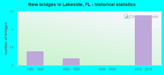
- New bridges - historical statistics
- 21980-1989
- 11990-1999
- 72010-2019


- Bridge Condition - Deck
- 50.0%Good
- 50.0%Poor

- Bridge Condition - Superstructure
- 50.0%Good
- 50.0%Poor

- Bridge Condition - Substructure
- 25.0%Very good
- 50.0%Good
- 25.0%Satisfactory

- Bridge Condition - Channel
- 25.0%Very good
- 25.0%Good
- 50.0%Satisfactory
Find on map >> Show street view
Structure Number: 710056, Location: 3.4 MI. N. OF CR-220 (Lat: 30.117586, Lng: -81.808125), Route carried "on" structure: State highway 21, Year Built: 1985, Year Reconstructed: 2010, Status: Open, Structure Length: 10.67m (35.01ft), Average Daily Traffic: 20,500 (year 2020), Truck Traffic: 4%, Average Future Daily Traffic: 35,568 (year 2042), Design Load: HS 20, Features Intersected: LITTLE BLACK CREEK
Minimum Vertical Clearance: 30+ m (98+ ft), Kilometerpoint: 12.031, Lanes on structure: 3, Base Highway Network: Yes, Owner: State Highway Agency, Approaching Roadway Width: 13.1m (43.0ft), Material/Design: Prestressed concrete, Design/Construction: Slab, Number Of Spans In Main Unit: 10, Length of Maximum Span: 10.7m (35.1ft), Curb or Sidewalk Widths: Left: 1.6m (5.2ft), Right: 0.0m, Curb-To-Curb Width: 13.2m (43.3ft), Out-to-Out Width: 16.2m (53.1ft)
Condition: Deck: Poor, Superstructure: Poor, Substructure: Satisfactory, Channel: Satisfactory, Operating Rating: 42.5 metric tons, Method Used To Determine Operating Rating: Load and Resistance Factor (LRFR), Inventory Rating: 35.3 metric tons, Method Used To Determine Inventory Rating: Load and Resistance Factor (LRFR), Structural Evaluation: Meets minimum limits, Deck Geometry: Somewhat better than minimum adequacy, Waterway Adequacy: Equal to present desirable criteria, Approach Roadway Alignment: Equal to present desirable criteria, Designated Inspection Frequency: Every 24 months, Other Special Inspection Frequency: Every 12 months, Inspection Date: August 2020, Other Special Inspection Date: August 2021, Deck Structure Type: Concrete Precast Panels, Wearing Surface/Protective System: Wearing Surface: Bituminous
Find on map >> Show street view
Structure Number: 710057, Location: 3.4 MI. N. OF CR-220 (Lat: 30.117222, Lng: -81.808056), Route carried "on" structure: State highway 21, Year Built: 1985, Year Reconstructed: 2010, Status: Open, Structure Length: 10.67m (35.01ft), Average Daily Traffic: 20,500 (year 2020), Truck Traffic: 4%, Average Future Daily Traffic: 35,568 (year 2042), Design Load: HS 20, Features Intersected: LITTLE BLACK CREEK
Minimum Vertical Clearance: 30+ m (98+ ft), Kilometerpoint: 12.031, Lanes on structure: 3, Base Highway Network: Yes, Owner: State Highway Agency, Approaching Roadway Width: 13.0m (42.7ft), Material/Design: Prestressed concrete, Design/Construction: Slab, Number Of Spans In Main Unit: 10, Length of Maximum Span: 10.7m (35.1ft), Curb or Sidewalk Widths: Left: 0.0m, Right: 1.6m (5.2ft), Curb-To-Curb Width: 13.2m (43.3ft), Out-to-Out Width: 16.2m (53.1ft)
Condition: Deck: Poor, Superstructure: Poor, Substructure: Good, Channel: Satisfactory, Operating Rating: 39.3 metric tons, Method Used To Determine Operating Rating: Load and Resistance Factor (LRFR), Inventory Rating: 34.6 metric tons, Method Used To Determine Inventory Rating: Load and Resistance Factor (LRFR), Structural Evaluation: Meets minimum limits, Deck Geometry: Somewhat better than minimum adequacy, Waterway Adequacy: Equal to present desirable criteria, Approach Roadway Alignment: Equal to present desirable criteria, Designated Inspection Frequency: Every 24 months, Other Special Inspection Frequency: Every 12 months, Inspection Date: August 2020, Other Special Inspection Date: August 2021, Deck Structure Type: Concrete Precast Panels, Wearing Surface/Protective System: Wearing Surface: Bituminous
Find on map >> Show street view
Structure Number: 710096, Location: 1.1 N of SR-21 (Lat: 30.119222, Lng: -81.831083), Route carried "on" structure: State highway 23, Year Built: 2014, Status: Open, Structure Length: 1.77m (5.81ft), Average Daily Traffic: 6,300 (year 2020), Truck Traffic: 5%, Average Future Daily Traffic: 10,930 (year 2042), Design Load: HL 93, Features Intersected: W. Prong Littl Black Crk
Minimum Vertical Clearance: 30+ m (98+ ft), Kilometerpoint: 2.195, Lanes on structure: 8, Owner: State Toll Authority, Approaching Roadway Width: 21.5m (70.5ft), Skew: 12 degrees, Material/Design: Concrete, Design/Construction: Culvert, Number Of Spans In Main Unit: 4, Length of Maximum Span: 3.7m (12.1ft)
Condition: Channel: Good, Culverts: Good, Operating Rating: 45.7 metric tons, Method Used To Determine Operating Rating: Load and Resistance Factor (LRFR), Inventory Rating: 35.3 metric tons, Method Used To Determine Inventory Rating: Load and Resistance Factor (LRFR), Structural Evaluation: Better than present minimum criteria, Waterway Adequacy: Equal to present desirable criteria, Approach Roadway Alignment: Equal to present desirable criteria, Designated Inspection Frequency: Every 24 months, Inspection Date: Febuary 2022
Find on map >> Show street view
Structure Number: 710097, Location: 1.08 MILES NORTH OF SR 21 (Lat: 30.114458, Lng: -81.832111), Route carried "on" structure: State highway 23, Year Built: 2017, Status: Open, Structure Length: 5.07m (16.63ft), Average Daily Traffic: 3,150 (year 2020), Truck Traffic: 5%, Average Future Daily Traffic: 5,465 (year 2042), Design Load: HL 93, Features Intersected: OLD JENNINGS ROAD
Minimum Vertical Clearance: 30+ m (98+ ft), Kilometerpoint: 1.661, Lanes on structure: 2, Lanes under structure: 5, Toll: On toll road, Owner: State Toll Authority, Approaching Roadway Width: 12.2m (40.0ft), Skew: 2 degrees, Material/Design: Prestressed concrete, Design/Construction: Stringer/Multi-beam, Number Of Spans In Main Unit: 1, Length of Maximum Span: 50.7m (166.3ft), Curb-To-Curb Width: 12.2m (40.0ft), Out-to-Out Width: 13.1m (43.0ft)
Condition: Deck: Good, Superstructure: Good, Substructure: Very good, Operating Rating: 67.0 metric tons, Method Used To Determine Operating Rating: Load and Resistance Factor (LRFR), Inventory Rating: 45.1 metric tons, Method Used To Determine Inventory Rating: Load and Resistance Factor (LRFR), Structural Evaluation: Better than present minimum criteria, Deck Geometry: Better than present minimum criteria, Underclear: Equal to present minimum criteria, Approach Roadway Alignment: Equal to present desirable criteria, Designated Inspection Frequency: Every 24 months, Inspection Date: March 2020, Deck Structure Type: Concrete Cast-file-Place
Find on map >> Show street view
Structure Number: 710098, Location: 1.08 MI NORTH OF SR 21 (Lat: 30.114467, Lng: -81.832506), Route carried "on" structure: State highway 23, Year Built: 2017, Status: Open, Structure Length: 5.07m (16.63ft), Average Daily Traffic: 3,150 (year 2020), Truck Traffic: 5%, Average Future Daily Traffic: 5,465 (year 2042), Design Load: HL 93, Features Intersected: OLD JENNINGS ROAD
Minimum Vertical Clearance: 30+ m (98+ ft), Kilometerpoint: 1.646, Lanes on structure: 2, Lanes under structure: 5, Toll: On toll road, Owner: State Toll Authority, Approaching Roadway Width: 12.2m (40.0ft), Skew: 2 degrees, Material/Design: Prestressed concrete, Design/Construction: Stringer/Multi-beam, Number Of Spans In Main Unit: 1, Length of Maximum Span: 50.7m (166.3ft), Curb-To-Curb Width: 12.2m (40.0ft), Out-to-Out Width: 13.1m (43.0ft)
Condition: Deck: Good, Superstructure: Good, Substructure: Good, Operating Rating: 68.2 metric tons, Method Used To Determine Operating Rating: Load and Resistance Factor (LRFR), Inventory Rating: 47.4 metric tons, Method Used To Determine Inventory Rating: Load and Resistance Factor (LRFR), Structural Evaluation: Better than present minimum criteria, Deck Geometry: Better than present minimum criteria, Underclear: Meets minimum limits, Approach Roadway Alignment: Equal to present desirable criteria, Designated Inspection Frequency: Every 24 months, Inspection Date: March 2020, Deck Structure Type: Concrete Cast-file-Place
Find on map >> Show street view
Structure Number: 714058, Location: 0.2 MI N OF CR 220 (Lat: 30.103500, Lng: -81.776389), Route carried "on" structure: County highway 224, Year Built: 1997, Status: Open, Structure Length: 0.85m (2.79ft), Average Daily Traffic: 18,500 (year 2020), Truck Traffic: 10%, Average Future Daily Traffic: 32,097 (year 2042), Design Load: HS 20, Features Intersected: PINEWOOD DRAINAGE CANAL
Minimum Vertical Clearance: 30+ m (98+ ft), Kilometerpoint: 0.381, Lanes on structure: 4, Owner: County Highway Agency, Approaching Roadway Width: 17.7m (58.1ft), Skew: 20 degrees, Material/Design: Concrete, Design/Construction: Culvert, Number Of Spans In Main Unit: 3, Length of Maximum Span: 2.4m (7.9ft), Curb or Sidewalk Widths: Left: 1.8m (5.9ft), Right: 1.8m (5.9ft)
Condition: Channel: Very good, Culverts: Good, Operating Rating: 32.7 metric tons, Method Used To Determine Operating Rating: Load Factor (LF), Inventory Rating: 19.6 metric tons, Method Used To Determine Inventory Rating: Load Factor (LF), Structural Evaluation: Meets minimum limits, Waterway Adequacy: Better than present minimum criteria, Approach Roadway Alignment: Equal to present desirable criteria, Designated Inspection Frequency: Every 24 months, Inspection Date: March 2020
Find on map >> Show street view
Structure Number: 710097, Location: 1.08 MILES NORTH OF SR 21 (Lat: 30.114458, Lng: -81.832111), Route carried "under" structure: County highway 220A, Year Built: 2017, Structure Length: 0. m, Average Daily Traffic: 19,100 (year 2020), Truck Traffic: 2%, Features Intersected: OLD JENNINGS ROAD, Facility Carried by Structure: SR 23 NB 32.1
Minimum Vertical Clearance: 5.39m (17.68ft), Kilometerpoint: 6.066, Lanes on structure: 2, Lanes under structure: 4, Material/Design: Prestressed concrete, Design/Construction: Stringer/Multi-beam, Length of Maximum Span: 50.7m (166.3ft)
Find on map >> Show street view
Structure Number: 710097, Location: 1.08 MILES NORTH OF SR 21 (Lat: 30.114458, Lng: -81.832111), Route carried "under" structure: ServiceCounty highway , Year Built: 2017, Structure Length: 0. m, Average Daily Traffic: 15,500 (year 2016), Truck Traffic: 3%, Features Intersected: OLD JENNINGS ROAD, Facility Carried by Structure: SR 23 NB 32.1
Minimum Vertical Clearance: 5.61m (18.41ft), Kilometerpoint: 0.000, Lanes on structure: 2, Lanes under structure: 1, Material/Design: Prestressed concrete, Design/Construction: Stringer/Multi-beam, Length of Maximum Span: 50.7m (166.3ft)
Find on map >> Show street view
Structure Number: 710098, Location: 1.08 MI NORTH OF SR 21 (Lat: 30.114467, Lng: -81.832506), Route carried "under" structure: ServiceCounty highway , Year Built: 2017, Structure Length: 0. m, Average Daily Traffic: 15,500 (year 2016), Truck Traffic: 3%, Features Intersected: OLD JENNINGS ROAD, Facility Carried by Structure: SR 23 SB 32.1
Minimum Vertical Clearance: 5.39m (17.68ft), Kilometerpoint: 0.000, Lanes on structure: 2, Lanes under structure: 1, Material/Design: Prestressed concrete, Design/Construction: Stringer/Multi-beam, Length of Maximum Span: 50.7m (166.3ft)
Find on map >> Show street view
Structure Number: 710098, Location: 1.08 MI NORTH OF SR 21 (Lat: 30.114467, Lng: -81.832506), Route carried "under" structure: County highway 220A, Year Built: 2017, Structure Length: 0. m, Average Daily Traffic: 19,100 (year 2020), Truck Traffic: 2%, Features Intersected: OLD JENNINGS ROAD, Facility Carried by Structure: SR 23 SB 32.1
Minimum Vertical Clearance: 5.30m (17.39ft), Kilometerpoint: 6.066, Lanes on structure: 2, Lanes under structure: 3, Material/Design: Prestressed concrete, Design/Construction: Stringer/Multi-beam, Length of Maximum Span: 50.7m (166.3ft)