Bridge Statistics for Lake Magdalene, Florida (FL)
Condition, Traffic, Stress, Structural Evaluation, Project Costs
- National Bridge Inventory (NBI) Statistics
- 32Number of bridges
- 354ft / 108mTotal length
- 792,905Total average daily traffic
- 78,294Total average daily truck traffic
- National Bridge Inventory (NBI) Registered Bridges for Lake Magdalene
- No street view available for this location
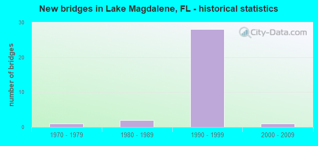
- New bridges - historical statistics
- 11970-1979
- 21980-1989
- 281990-1999
- 12000-2009


- Bridge Condition - Deck
- 5.6%Very good
- 94.4%Good

- Bridge Condition - Superstructure
- 61.1%Very good
- 38.9%Good

- Bridge Condition - Substructure
- 5.6%Very good
- 94.4%Good

- Bridge Condition - Channel
- 83.3%Good
- 16.7%Fair
Find on map >> Show street view
Structure Number: 10055, Location: 0.4MI S OF CR-765 (Lat: 26.887689, Lng: -82.020275), Route carried "on" structure: US 41, Year Built: 1981, Status: Open, Structure Length: 5.55m (18.21ft), Average Daily Traffic: 6,550 (year 2020), Truck Traffic: 13%, Average Future Daily Traffic: 11,364 (year 2042), Design Load: HS 20, Features Intersected: ALLIGATOR CREEK
Minimum Vertical Clearance: 30+ m (98+ ft), Kilometerpoint: 15.841, Lanes on structure: 2, Base Highway Network: Yes, Owner: State Highway Agency, Approaching Roadway Width: 12.2m (40.0ft), Skew: 2 degrees, Material/Design: Concrete continuous, Design/Construction: Slab, Number Of Spans In Main Unit: 7, Length of Maximum Span: 7.9m (25.9ft), Curb-To-Curb Width: 12.2m (40.0ft), Out-to-Out Width: 13.1m (43.0ft)
Condition: Deck: Good, Superstructure: Good, Substructure: Good, Channel: Good, Operating Rating: 75.0 metric tons, Method Used To Determine Operating Rating: Load Factor (LF), Inventory Rating: 44.9 metric tons, Method Used To Determine Inventory Rating: Load Factor (LF), Structural Evaluation: Better than present minimum criteria, Deck Geometry: Better than present minimum criteria, Waterway Adequacy: Equal to present desirable criteria, Approach Roadway Alignment: Equal to present desirable criteria, Designated Inspection Frequency: Every 24 months, Underwater Inspection Frequency: Every 24 months, Inspection Date: June 2020, Underwater Inspection Date: May 2020, Deck Structure Type: Concrete Cast-file-Place, Wearing Surface/Protective System: Wearing Surface: Monolithic Concrete
Find on map >> Show street view
Structure Number: 10056, Location: 1MI NORTH OF CR-765 (Lat: 26.902169, Lng: -82.034211), Route carried "on" structure: US 41, Year Built: 1981, Status: Open, Structure Length: 3.35m (10.99ft), Average Daily Traffic: 13,250 (year 2020), Truck Traffic: 8%, Average Future Daily Traffic: 22,989 (year 2042), Design Load: HS 20, Features Intersected: OYSTER CREEK
Minimum Vertical Clearance: 30+ m (98+ ft), Kilometerpoint: 17.965, Lanes on structure: 2, Base Highway Network: Yes, Owner: State Highway Agency, Approaching Roadway Width: 13.4m (44.0ft), Skew: 2 degrees, Material/Design: Concrete continuous, Design/Construction: Slab, Number Of Spans In Main Unit: 5, Length of Maximum Span: 6.7m (22.0ft), Curb-To-Curb Width: 12.1m (39.7ft), Out-to-Out Width: 13.1m (43.0ft)
Condition: Deck: Good, Superstructure: Good, Substructure: Good, Channel: Good, Operating Rating: 69.9 metric tons, Method Used To Determine Operating Rating: Load Factor (LF), Inventory Rating: 41.8 metric tons, Method Used To Determine Inventory Rating: Load Factor (LF), Structural Evaluation: Better than present minimum criteria, Deck Geometry: Better than present minimum criteria, Waterway Adequacy: Equal to present desirable criteria, Approach Roadway Alignment: Equal to present desirable criteria, Designated Inspection Frequency: Every 24 months, Underwater Inspection Frequency: Every 24 months, Inspection Date: June 2020, Underwater Inspection Date: May 2020, Deck Structure Type: Concrete Cast-file-Place, Wearing Surface/Protective System: Wearing Surface: Bituminous
Find on map >> Show street view
Structure Number: 10055, Location: 0.2 MI NORTH OF GUNN HWY (Lat: 28.068847, Lng: -82.565750), Route carried "on" structure: State highway 589, Year Built: 1994, Year Reconstructed: 2017, Status: Open, Structure Length: 9.14m (29.99ft), Average Daily Traffic: 27,500 (year 2020), Truck Traffic: 10%, Average Future Daily Traffic: 47,712 (year 2042), Design Load: HL 93, Features Intersected: ROCKY CREEK II
Minimum Vertical Clearance: 30+ m (98+ ft), Kilometerpoint: 12.822, Lanes on structure: 5, Base Highway Network: Yes, Toll: On toll road, Owner: State Toll Authority, Approaching Roadway Width: 28.0m (91.9ft), Material/Design: Prestressed concrete, Design/Construction: Stringer/Multi-beam, Number Of Spans In Main Unit: 4, Length of Maximum Span: 22.9m (75.1ft), Curb-To-Curb Width: 28.0m (91.9ft), Out-to-Out Width: 28.4m (93.2ft)
Condition: Deck: Good, Superstructure: Very good, Substructure: Good, Channel: Good, Operating Rating: 46.1 metric tons, Method Used To Determine Operating Rating: Load and Resistance Factor (LRFR), Inventory Rating: 38.2 metric tons, Method Used To Determine Inventory Rating: Load and Resistance Factor (LRFR), Structural Evaluation: Better than present minimum criteria, Deck Geometry: Superior to present desirable criteria, Waterway Adequacy: Superior to present desirable criteria, Approach Roadway Alignment: Equal to present desirable criteria, Designated Inspection Frequency: Every 24 months, Inspection Date: March 2020, Deck Structure Type: Concrete Cast-file-Place
Find on map >> Show street view
Structure Number: 100551, Location: 0.2 MI NORTH OF GUNN HWY (Lat: 28.068700, Lng: -82.565553), Route carried "on" structure: State highway 589, Year Built: 1994, Year Reconstructed: 2017, Status: Open, Structure Length: 9.14m (29.99ft), Average Daily Traffic: 27,500 (year 2020), Truck Traffic: 10%, Average Future Daily Traffic: 47,712 (year 2042), Design Load: HL 93, Features Intersected: ROCKY CREEK II
Minimum Vertical Clearance: 30+ m (98+ ft), Kilometerpoint: 12.822, Lanes on structure: 5, Base Highway Network: Yes, Toll: On toll road, Owner: State Toll Authority, Approaching Roadway Width: 24.3m (79.7ft), Material/Design: Prestressed concrete, Design/Construction: Stringer/Multi-beam, Number Of Spans In Main Unit: 4, Length of Maximum Span: 22.9m (75.1ft), Curb-To-Curb Width: 24.3m (79.7ft), Out-to-Out Width: 26.8m (87.9ft)
Condition: Deck: Good, Superstructure: Very good, Substructure: Good, Channel: Fair, Operating Rating: 47.7 metric tons, Method Used To Determine Operating Rating: Load and Resistance Factor (LRFR), Inventory Rating: 39.2 metric tons, Method Used To Determine Inventory Rating: Load and Resistance Factor (LRFR), Structural Evaluation: Better than present minimum criteria, Deck Geometry: Equal to present minimum criteria, Waterway Adequacy: Superior to present desirable criteria, Approach Roadway Alignment: Equal to present desirable criteria, Designated Inspection Frequency: Every 24 months, Inspection Date: March 2020, Deck Structure Type: Concrete Cast-file-Place
Find on map >> Show street view
Structure Number: 100552, Location: 0.5 MI S OF BELLAMY RD (Lat: 28.078653, Lng: -82.562397), Route carried "on" structure: State highway 589, Year Built: 1994, Year Reconstructed: 2017, Status: Open, Structure Length: 6.34m (20.80ft), Average Daily Traffic: 27,500 (year 2020), Truck Traffic: 10%, Average Future Daily Traffic: 47,712 (year 2042), Design Load: HL 93, Features Intersected: EHRLICH RD
Minimum Vertical Clearance: 30+ m (98+ ft), Kilometerpoint: 13.987, Lanes on structure: 3, Lanes under structure: 5, Base Highway Network: Yes, Toll: On toll road, Owner: State Toll Authority, Approaching Roadway Width: 21.2m (69.6ft), Skew: 2 degrees, Material/Design: Steel, Design/Construction: Stringer/Multi-beam, Number Of Spans In Main Unit: 1, Length of Maximum Span: 63.4m (208.0ft), Curb-To-Curb Width: 21.2m (69.6ft), Out-to-Out Width: 21.9m (71.9ft)
Condition: Deck: Good, Superstructure: Very good, Substructure: Good, Operating Rating: 53.9 metric tons, Method Used To Determine Operating Rating: Load and Resistance Factor (LRFR), Inventory Rating: 41.5 metric tons, Method Used To Determine Inventory Rating: Load and Resistance Factor (LRFR), Structural Evaluation: Better than present minimum criteria, Deck Geometry: Superior to present desirable criteria, Underclear: Superior to present desirable criteria, Approach Roadway Alignment: Equal to present desirable criteria, Designated Inspection Frequency: Every 24 months, Inspection Date: March 2020, Deck Structure Type: Concrete Cast-file-Place
Find on map >> Show street view
Structure Number: 100553, Location: 0.5 MI S OF BELLAMY RD (Lat: 28.078639, Lng: -82.562164), Route carried "on" structure: State highway 589, Year Built: 1994, Year Reconstructed: 2017, Status: Open, Structure Length: 6.34m (20.80ft), Average Daily Traffic: 25,900 (year 2020), Truck Traffic: 10%, Average Future Daily Traffic: 44,936 (year 2042), Design Load: HL 93, Features Intersected: EHRLICH RD
Minimum Vertical Clearance: 30+ m (98+ ft), Kilometerpoint: 13.995, Lanes on structure: 3, Lanes under structure: 5, Base Highway Network: Yes, Toll: On toll road, Owner: State Toll Authority, Approaching Roadway Width: 22.3m (73.2ft), Skew: 2 degrees, Material/Design: Steel, Design/Construction: Stringer/Multi-beam, Number Of Spans In Main Unit: 1, Length of Maximum Span: 63.4m (208.0ft), Curb-To-Curb Width: 22.3m (73.2ft), Out-to-Out Width: 22.3m (73.2ft)
Condition: Deck: Good, Superstructure: Very good, Substructure: Good, Operating Rating: 53.9 metric tons, Method Used To Determine Operating Rating: Load and Resistance Factor (LRFR), Inventory Rating: 41.5 metric tons, Method Used To Determine Inventory Rating: Load and Resistance Factor (LRFR), Structural Evaluation: Better than present minimum criteria, Deck Geometry: Superior to present desirable criteria, Underclear: Superior to present desirable criteria, Approach Roadway Alignment: Equal to present desirable criteria, Designated Inspection Frequency: Every 24 months, Inspection Date: March 2020, Deck Structure Type: Concrete Cast-file-Place
Find on map >> Show street view
Structure Number: 100554, Location: 0.5 MI N OF EHRLICH RD (Lat: 28.084517, Lng: -82.558383), Route carried "on" structure: State highway 589, Year Built: 1994, Year Reconstructed: 2017, Status: Open, Structure Length: 2.80m (9.19ft), Average Daily Traffic: 25,900 (year 2020), Truck Traffic: 10%, Average Future Daily Traffic: 44,936 (year 2042), Design Load: HL 93, Features Intersected: BELLAMY RD
Minimum Vertical Clearance: 30+ m (98+ ft), Kilometerpoint: 14.775, Lanes on structure: 4, Lanes under structure: 2, Base Highway Network: Yes, Toll: On toll road, Owner: State Toll Authority, Approaching Roadway Width: 21.3m (69.9ft), Skew: 2 degrees, Material/Design: Prestressed concrete, Design/Construction: Stringer/Multi-beam, Number Of Spans In Main Unit: 1, Length of Maximum Span: 28.0m (91.9ft), Curb-To-Curb Width: 21.3m (69.9ft), Out-to-Out Width: 22.3m (73.2ft)
Condition: Deck: Good, Superstructure: Very good, Substructure: Good, Operating Rating: 48.6 metric tons, Method Used To Determine Operating Rating: Load and Resistance Factor (LRFR), Inventory Rating: 44.1 metric tons, Method Used To Determine Inventory Rating: Load and Resistance Factor (LRFR), Structural Evaluation: Better than present minimum criteria, Deck Geometry: Better than present minimum criteria, Underclear: Superior to present desirable criteria, Approach Roadway Alignment: Equal to present desirable criteria, Designated Inspection Frequency: Every 24 months, Inspection Date: March 2020, Deck Structure Type: Concrete Cast-file-Place
Find on map >> Show street view
Structure Number: 100555, Location: 0.5 MI N OF EHRLICH RD (Lat: 28.084297, Lng: -82.558342), Route carried "on" structure: State highway 589, Year Built: 1994, Year Reconstructed: 2017, Status: Open, Structure Length: 2.80m (9.19ft), Average Daily Traffic: 25,900 (year 2020), Truck Traffic: 10%, Average Future Daily Traffic: 44,936 (year 2042), Design Load: HL 93, Features Intersected: BELLAMY RD
Minimum Vertical Clearance: 30+ m (98+ ft), Kilometerpoint: 14.763, Lanes on structure: 4, Lanes under structure: 2, Base Highway Network: Yes, Toll: On toll road, Owner: State Toll Authority, Approaching Roadway Width: 21.3m (69.9ft), Skew: 2 degrees, Material/Design: Prestressed concrete, Design/Construction: Stringer/Multi-beam, Number Of Spans In Main Unit: 1, Length of Maximum Span: 28.0m (91.9ft), Curb-To-Curb Width: 21.3m (69.9ft), Out-to-Out Width: 22.3m (73.2ft)
Condition: Deck: Good, Superstructure: Good, Substructure: Good, Operating Rating: 47.4 metric tons, Method Used To Determine Operating Rating: Load and Resistance Factor (LRFR), Inventory Rating: 41.5 metric tons, Method Used To Determine Inventory Rating: Load and Resistance Factor (LRFR), Structural Evaluation: Better than present minimum criteria, Deck Geometry: Better than present minimum criteria, Underclear: Superior to present desirable criteria, Approach Roadway Alignment: Equal to present desirable criteria, Designated Inspection Frequency: Every 24 months, Inspection Date: March 2020, Deck Structure Type: Concrete Cast-file-Place
Find on map >> Show street view
Structure Number: 100556, Location: 1.5 MI N OF EHRLICH ROAD (Lat: 28.092197, Lng: -82.545258), Route carried "on" structure: State highway 589, Year Built: 1994, Year Reconstructed: 2018, Status: Open, Structure Length: 4.57m (14.99ft), Average Daily Traffic: 25,900 (year 2020), Truck Traffic: 10%, Average Future Daily Traffic: 44,936 (year 2042), Design Load: HL 93, Features Intersected: RAWLS RD.
Minimum Vertical Clearance: 30+ m (98+ ft), Kilometerpoint: 16.441, Lanes on structure: 4, Lanes under structure: 2, Base Highway Network: Yes, Toll: On toll road, Owner: State Toll Authority, Approaching Roadway Width: 21.0m (68.9ft), Skew: 2 degrees, Material/Design: Prestressed concrete, Design/Construction: Stringer/Multi-beam, Number Of Spans In Main Unit: 3, Length of Maximum Span: 20.7m (67.9ft), Curb-To-Curb Width: 21.0m (68.9ft), Out-to-Out Width: 21.8m (71.5ft)
Condition: Deck: Very good, Superstructure: Very good, Substructure: Good, Operating Rating: 45.1 metric tons, Method Used To Determine Operating Rating: Load and Resistance Factor (LRFR), Inventory Rating: 39.8 metric tons, Method Used To Determine Inventory Rating: Load and Resistance Factor (LRFR), Structural Evaluation: Better than present minimum criteria, Deck Geometry: Better than present minimum criteria, Underclear: Superior to present desirable criteria, Approach Roadway Alignment: Equal to present desirable criteria, Designated Inspection Frequency: Every 24 months, Inspection Date: March 2020, Deck Structure Type: Concrete Cast-file-Place
Find on map >> Show street view
Structure Number: 100557, Location: 1.5 MI N OF EHRLICH ROAD (Lat: 28.092158, Lng: -82.545039), Route carried "on" structure: State highway 589, Year Built: 1994, Year Reconstructed: 2018, Status: Open, Structure Length: 4.57m (14.99ft), Average Daily Traffic: 25,900 (year 2020), Truck Traffic: 10%, Average Future Daily Traffic: 44,936 (year 2042), Design Load: HL 93, Features Intersected: RAWLS RD.
Minimum Vertical Clearance: 30+ m (98+ ft), Kilometerpoint: 16.449, Lanes on structure: 4, Lanes under structure: 2, Base Highway Network: Yes, Toll: On toll road, Owner: State Toll Authority, Approaching Roadway Width: 20.8m (68.2ft), Skew: 2 degrees, Material/Design: Prestressed concrete, Design/Construction: Stringer/Multi-beam, Number Of Spans In Main Unit: 3, Length of Maximum Span: 20.7m (67.9ft), Curb-To-Curb Width: 20.8m (68.2ft), Out-to-Out Width: 21.7m (71.2ft)
Condition: Deck: Good, Superstructure: Good, Substructure: Good, Operating Rating: 43.5 metric tons, Method Used To Determine Operating Rating: Load and Resistance Factor (LRFR), Inventory Rating: 39.2 metric tons, Method Used To Determine Inventory Rating: Load and Resistance Factor (LRFR), Structural Evaluation: Better than present minimum criteria, Deck Geometry: Equal to present minimum criteria, Underclear: Better than present minimum criteria, Approach Roadway Alignment: Equal to present desirable criteria, Designated Inspection Frequency: Every 24 months, Inspection Date: March 2020, Deck Structure Type: Concrete Cast-file-Place
Find on map >> Show street view
Structure Number: 100558, Location: 1.9 MI N OF EHRLICH ROAD (Lat: 28.097819, Lng: -82.542817), Route carried "on" structure: State highway 589, Year Built: 1994, Year Reconstructed: 2018, Status: Open, Structure Length: 8.61m (28.25ft), Average Daily Traffic: 28,700 (year 2020), Truck Traffic: 10%, Average Future Daily Traffic: 49,794 (year 2042), Design Load: HL 93, Features Intersected: HUTCHISON RD.
Minimum Vertical Clearance: 30+ m (98+ ft), Kilometerpoint: 17.090, Lanes on structure: 4, Lanes under structure: 4, Base Highway Network: Yes, Toll: On toll road, Owner: State Toll Authority, Approaching Roadway Width: 21.0m (68.9ft), Skew: 4 degrees, Material/Design: Prestressed concrete, Design/Construction: Stringer/Multi-beam, Number Of Spans In Main Unit: 4, Length of Maximum Span: 27.7m (90.9ft), Curb-To-Curb Width: 21.0m (68.9ft), Out-to-Out Width: 21.8m (71.5ft)
Condition: Deck: Good, Superstructure: Very good, Substructure: Good, Operating Rating: 47.4 metric tons, Method Used To Determine Operating Rating: Load and Resistance Factor (LRFR), Inventory Rating: 38.8 metric tons, Method Used To Determine Inventory Rating: Load and Resistance Factor (LRFR), Structural Evaluation: Better than present minimum criteria, Deck Geometry: Better than present minimum criteria, Underclear: Superior to present desirable criteria, Approach Roadway Alignment: Equal to present desirable criteria, Designated Inspection Frequency: Every 24 months, Inspection Date: March 2020, Deck Structure Type: Concrete Cast-file-Place
Find on map >> Show street view
Structure Number: 100559, Location: 1.9 MI N OF EHRLICH ROAD (Lat: 28.097558, Lng: -82.542678), Route carried "on" structure: State highway 589, Year Built: 1994, Year Reconstructed: 2018, Status: Open, Structure Length: 8.44m (27.69ft), Average Daily Traffic: 25,900 (year 2020), Truck Traffic: 10%, Average Future Daily Traffic: 44,936 (year 2042), Design Load: HL 93, Features Intersected: HUTCHISON RD.
Minimum Vertical Clearance: 30+ m (98+ ft), Kilometerpoint: 17.072, Lanes on structure: 4, Lanes under structure: 4, Base Highway Network: Yes, Toll: On toll road, Owner: State Toll Authority, Approaching Roadway Width: 20.8m (68.2ft), Skew: 4 degrees, Material/Design: Prestressed concrete, Design/Construction: Stringer/Multi-beam, Number Of Spans In Main Unit: 4, Length of Maximum Span: 27.3m (89.6ft), Curb-To-Curb Width: 20.8m (68.2ft), Out-to-Out Width: 21.7m (71.2ft)
Condition: Deck: Good, Superstructure: Good, Substructure: Good, Operating Rating: 47.4 metric tons, Method Used To Determine Operating Rating: Load and Resistance Factor (LRFR), Inventory Rating: 38.8 metric tons, Method Used To Determine Inventory Rating: Load and Resistance Factor (LRFR), Structural Evaluation: Better than present minimum criteria, Deck Geometry: Equal to present minimum criteria, Underclear: Superior to present desirable criteria, Approach Roadway Alignment: Equal to present desirable criteria, Designated Inspection Frequency: Every 24 months, Inspection Date: March 2020, Deck Structure Type: Concrete Cast-file-Place
Find on map >> Show street view
Structure Number: 10056, Location: 1.6MI N OF SUGARWOOD TOLL (Lat: 28.106614, Lng: -82.542900), Route carried "on" structure: State highway 589, Year Built: 1994, Year Reconstructed: 2018, Status: Open, Structure Length: 7.32m (24.02ft), Average Daily Traffic: 28,700 (year 2020), Truck Traffic: 10%, Average Future Daily Traffic: 49,794 (year 2042), Design Load: HL 93, Features Intersected: HATTON WILCOX RD.
Minimum Vertical Clearance: 30+ m (98+ ft), Kilometerpoint: 18.110, Lanes on structure: 4, Lanes under structure: 2, Base Highway Network: Yes, Toll: On toll road, Owner: State Toll Authority, Approaching Roadway Width: 22.6m (74.1ft), Skew: 4 degrees, Material/Design: Prestressed concrete, Design/Construction: Stringer/Multi-beam, Number Of Spans In Main Unit: 3, Length of Maximum Span: 35.1m (115.2ft), Curb-To-Curb Width: 22.6m (74.1ft), Out-to-Out Width: 23.3m (76.4ft)
Condition: Deck: Good, Superstructure: Very good, Substructure: Good, Operating Rating: 41.2 metric tons, Method Used To Determine Operating Rating: Load and Resistance Factor (LRFR), Inventory Rating: 32.7 metric tons, Method Used To Determine Inventory Rating: Load and Resistance Factor (LRFR), Structural Evaluation: Better than present minimum criteria, Deck Geometry: Superior to present desirable criteria, Underclear: Superior to present desirable criteria, Approach Roadway Alignment: Equal to present desirable criteria, Designated Inspection Frequency: Every 24 months, Inspection Date: March 2020, Deck Structure Type: Concrete Cast-file-Place
Find on map >> Show street view
Structure Number: 100561, Location: 1.6MI N OF SUGARWOOD TOLL (Lat: 28.106514, Lng: -82.542567), Route carried "on" structure: State highway 589, Year Built: 1994, Year Reconstructed: 2018, Status: Open, Structure Length: 7.06m (23.16ft), Average Daily Traffic: 28,700 (year 2020), Truck Traffic: 10%, Average Future Daily Traffic: 49,794 (year 2042), Design Load: HL 93, Features Intersected: HATTON WILCOX RD.
Minimum Vertical Clearance: 30+ m (98+ ft), Kilometerpoint: 18.086, Lanes on structure: 4, Lanes under structure: 2, Base Highway Network: Yes, Toll: On toll road, Owner: State Toll Authority, Approaching Roadway Width: 22.6m (74.1ft), Skew: 4 degrees, Material/Design: Prestressed concrete, Design/Construction: Stringer/Multi-beam, Number Of Spans In Main Unit: 3, Length of Maximum Span: 33.7m (110.6ft), Curb-To-Curb Width: 22.6m (74.1ft), Out-to-Out Width: 24.7m (81.0ft)
Condition: Deck: Good, Superstructure: Very good, Substructure: Good, Operating Rating: 41.5 metric tons, Method Used To Determine Operating Rating: Load and Resistance Factor (LRFR), Inventory Rating: 32.7 metric tons, Method Used To Determine Inventory Rating: Load and Resistance Factor (LRFR), Structural Evaluation: Better than present minimum criteria, Deck Geometry: Superior to present desirable criteria, Underclear: Superior to present desirable criteria, Approach Roadway Alignment: Equal to present desirable criteria, Designated Inspection Frequency: Every 24 months, Inspection Date: March 2020, Deck Structure Type: Concrete Cast-file-Place
Find on map >> Show street view
Structure Number: 100562, Location: 2.2MI N OF SUGARWOOD TOLL (Lat: 28.113969, Lng: -82.546178), Route carried "on" structure: State highway 589, Year Built: 1994, Year Reconstructed: 2018, Status: Open, Structure Length: 4.30m (14.11ft), Average Daily Traffic: 28,700 (year 2020), Truck Traffic: 10%, Average Future Daily Traffic: 49,794 (year 2042), Design Load: HL 93, Features Intersected: LAKE LECLARE RD.
Minimum Vertical Clearance: 30+ m (98+ ft), Kilometerpoint: 19.000, Lanes on structure: 4, Lanes under structure: 2, Base Highway Network: Yes, Toll: On toll road, Owner: State Toll Authority, Approaching Roadway Width: 20.9m (68.6ft), Material/Design: Prestressed concrete, Design/Construction: Stringer/Multi-beam, Number Of Spans In Main Unit: 3, Length of Maximum Span: 19.5m (64.0ft), Curb-To-Curb Width: 20.9m (68.6ft), Out-to-Out Width: 21.6m (70.9ft)
Condition: Deck: Good, Superstructure: Very good, Substructure: Very good, Operating Rating: 40.8 metric tons, Method Used To Determine Operating Rating: Load and Resistance Factor (LRFR), Inventory Rating: 32.7 metric tons, Method Used To Determine Inventory Rating: Load and Resistance Factor (LRFR), Structural Evaluation: Equal to present desirable criteria, Deck Geometry: Better than present minimum criteria, Underclear: Superior to present desirable criteria, Approach Roadway Alignment: Equal to present desirable criteria, Designated Inspection Frequency: Every 24 months, Inspection Date: March 2020, Deck Structure Type: Concrete Cast-file-Place
Find on map >> Show street view
Structure Number: 100563, Location: 2.2MI N OF SUGARWOOD TOLL (Lat: 28.113944, Lng: -82.545925), Route carried "on" structure: State highway 589, Year Built: 1994, Year Reconstructed: 2018, Status: Open, Structure Length: 4.30m (14.11ft), Average Daily Traffic: 28,700 (year 2020), Truck Traffic: 10%, Average Future Daily Traffic: 49,794 (year 2042), Design Load: HL 93, Features Intersected: LAKE LECLARE RD.
Minimum Vertical Clearance: 30+ m (98+ ft), Kilometerpoint: 19.000, Lanes on structure: 4, Lanes under structure: 2, Base Highway Network: Yes, Toll: On toll road, Owner: State Toll Authority, Approaching Roadway Width: 20.9m (68.6ft), Material/Design: Prestressed concrete, Design/Construction: Stringer/Multi-beam, Number Of Spans In Main Unit: 3, Length of Maximum Span: 19.5m (64.0ft), Curb-To-Curb Width: 20.9m (68.6ft), Out-to-Out Width: 21.6m (70.9ft)
Condition: Deck: Good, Superstructure: Very good, Substructure: Good, Operating Rating: 40.8 metric tons, Method Used To Determine Operating Rating: Load and Resistance Factor (LRFR), Inventory Rating: 32.7 metric tons, Method Used To Determine Inventory Rating: Load and Resistance Factor (LRFR), Structural Evaluation: Better than present minimum criteria, Deck Geometry: Better than present minimum criteria, Underclear: Superior to present desirable criteria, Approach Roadway Alignment: Equal to present desirable criteria, Designated Inspection Frequency: Every 24 months, Inspection Date: March 2020, Deck Structure Type: Concrete Cast-file-Place
Find on map >> Show street view
Structure Number: 100624, Location: 2.8MI N OF SUGARWOOD TOLL (Lat: 28.122069, Lng: -82.546275), Route carried "on" structure: State highway 589, Year Built: 1999, Status: Open, Structure Length: 11.50m (37.73ft), Average Daily Traffic: 20,000 (year 2020), Truck Traffic: 10%, Average Future Daily Traffic: 34,700 (year 2042), Design Load: HS 20+Mod, Features Intersected: SUNCOAST PARKWAY
Minimum Vertical Clearance: 30+ m (98+ ft), Kilometerpoint: 0.000, Lanes on structure: 2, Lanes under structure: 4, Base Highway Network: Yes, Toll: On toll road, Owner: State Toll Authority, Approaching Roadway Width: 13.5m (44.3ft), Skew: 9 degrees, Material/Design: Steel continuous, Design/Construction: Stringer/Multi-beam, Number Of Spans In Main Unit: 2, Length of Maximum Span: 64.3m (211.0ft), Curb-To-Curb Width: 13.5m (44.3ft), Out-to-Out Width: 14.4m (47.2ft)
Condition: Deck: Good, Superstructure: Good, Substructure: Good, Operating Rating: 58.4 metric tons, Method Used To Determine Operating Rating: Load Factor (LF), Inventory Rating: 34.9 metric tons, Method Used To Determine Inventory Rating: Load Factor (LF), Structural Evaluation: Better than present minimum criteria, Deck Geometry: Superior to present desirable criteria, Underclear: Better than present minimum criteria, Approach Roadway Alignment: Equal to present desirable criteria, Designated Inspection Frequency: Every 24 months, Inspection Date: March 2020, Deck Structure Type: Concrete Cast-file-Place
Find on map >> Show street view
Structure Number: 104208, Location: 0.4 MI S OF FLETCHER AV (Lat: 28.056061, Lng: -82.500572), Route carried "on" structure: County highway , Year Built: 1973, Status: Open, Structure Length: 0.93m (3.05ft), Average Daily Traffic: 5,240 (year 2021), Truck Traffic: 5%, Average Future Daily Traffic: 6,550 (year 2041), Design Load: H 15, Features Intersected: SWEETWATER CREEK, Facility Carried by Structure: ORANGE GROVE DRIVE
Minimum Vertical Clearance: 30+ m (98+ ft), Kilometerpoint: 0.000, Lanes on structure: 2, Owner: County Highway Agency, Approaching Roadway Width: 6.3m (20.7ft), Material/Design: Prestressed concrete, Design/Construction: Channel Beam, Number Of Spans In Main Unit: 1, Length of Maximum Span: 9.3m (30.5ft), Curb or Sidewalk Widths: Left: 0.6m (2.0ft), Right: 0.6m (2.0ft), Curb-To-Curb Width: 8.0m (26.2ft), Out-to-Out Width: 9.7m (31.8ft)
Condition: Deck: Good, Superstructure: Good, Substructure: Good, Channel: Good, Operating Rating: 47.7 metric tons, Method Used To Determine Operating Rating: Load Factor (LF), Inventory Rating: 28.6 metric tons, Method Used To Determine Inventory Rating: Load Factor (LF), Structural Evaluation: Better than present minimum criteria, Deck Geometry: High priority of replacement, Waterway Adequacy: Better than present minimum criteria, Approach Roadway Alignment: Equal to present desirable criteria, Designated Inspection Frequency: Every 24 months, Inspection Date: April 2021, Deck Structure Type: Concrete Cast-file-Place, Wearing Surface/Protective System: Wearing Surface: Bituminous
Find on map >> Show street view
Structure Number: 104291, Location: 0.7MI S OF BEARSS AVE (Lat: 28.073733, Lng: -82.500317), Route carried "on" structure: County highway , Year Built: 2001, Status: Open, Structure Length: 1.06m (3.48ft), Average Daily Traffic: 2,565 (year 2021), Truck Traffic: 2%, Average Future Daily Traffic: 2,027 (year 2041), Design Load: HS 20, Features Intersected: MAGDALENE CANAL, Facility Carried by Structure: EHRLICH ROAD
Minimum Vertical Clearance: 30+ m (98+ ft), Kilometerpoint: 0.000, Lanes on structure: 2, Owner: County Highway Agency, Approaching Roadway Width: 6.3m (20.7ft), Skew: 2 degrees, Material/Design: Concrete, Design/Construction: Culvert, Number Of Spans In Main Unit: 3, Length of Maximum Span: 3.3m (10.8ft)
Condition: Channel: Good, Culverts: Good, Operating Rating: 64.8 metric tons, Method Used To Determine Operating Rating: Load Factor (LF), Inventory Rating: 38.8 metric tons, Method Used To Determine Inventory Rating: Load Factor (LF), Structural Evaluation: Better than present minimum criteria, Waterway Adequacy: Equal to present desirable criteria, Approach Roadway Alignment: Somewhat better than minimum adequacy, Designated Inspection Frequency: Every 24 months, Inspection Date: April 2021
Find on map >> Show street view
Structure Number: 100552, Location: 0.5 MI S OF BELLAMY RD (Lat: 28.078653, Lng: -82.562397), Route carried "under" structure: County highway , Year Built: 1994, Structure Length: 0. m, Average Daily Traffic: 23,000 (year 2020), Truck Traffic: 9%, Features Intersected: EHRLICH RD, Facility Carried by Structure: SR 589 VET SB 10.2
Minimum Vertical Clearance: 5.82m (19.09ft), Kilometerpoint: 1.561, Lanes on structure: 3, Lanes under structure: 5, Material/Design: Steel, Design/Construction: Stringer/Multi-beam, Length of Maximum Span: 63.4m (208.0ft)
Find on map >> Show street view
Structure Number: 100553, Location: 0.5 MI S OF BELLAMY RD (Lat: 28.078639, Lng: -82.562164), Route carried "under" structure: County highway , Year Built: 1994, Structure Length: 0. m, Average Daily Traffic: 23,000 (year 2020), Truck Traffic: 9%, Features Intersected: EHRLICH RD, Facility Carried by Structure: SR 589 VET NB 10.2
Minimum Vertical Clearance: 5.06m (16.60ft), Kilometerpoint: 1.593, Lanes on structure: 3, Lanes under structure: 5, Material/Design: Steel, Design/Construction: Stringer/Multi-beam, Length of Maximum Span: 63.4m (208.0ft)
Find on map >> Show street view
Structure Number: 100554, Location: 0.5 MI N OF EHRLICH RD (Lat: 28.084517, Lng: -82.558383), Route carried "under" structure: City street , Year Built: 1994, Structure Length: 0. m, Average Daily Traffic: 25,900 (year 2020), Truck Traffic: 10%, Features Intersected: BELLAMY RD, Facility Carried by Structure: SR 589 VET SB 10.7
Minimum Vertical Clearance: 6.22m (20.41ft), Kilometerpoint: 14.779, Lanes on structure: 4, Lanes under structure: 2, Material/Design: Prestressed concrete, Design/Construction: Stringer/Multi-beam, Length of Maximum Span: 28.0m (91.9ft)
Find on map >> Show street view
Structure Number: 100555, Location: 0.5 MI N OF EHRLICH RD (Lat: 28.084297, Lng: -82.558342), Route carried "under" structure: City street , Year Built: 1994, Structure Length: 0. m, Average Daily Traffic: 25,900 (year 2020), Truck Traffic: 10%, Features Intersected: BELLAMY RD, Facility Carried by Structure: SR 589 VET NB 10.7
Minimum Vertical Clearance: 5.21m (17.09ft), Kilometerpoint: 14.766, Lanes on structure: 4, Lanes under structure: 2, Material/Design: Prestressed concrete, Design/Construction: Stringer/Multi-beam, Length of Maximum Span: 28.0m (91.9ft)
Find on map >> Show street view
Structure Number: 100556, Location: 1.5 MI N OF EHRLICH ROAD (Lat: 28.092197, Lng: -82.545258), Route carried "under" structure: City street , Year Built: 1994, Structure Length: 0. m, Average Daily Traffic: 25,900 (year 2020), Truck Traffic: 10%, Features Intersected: RAWLS RD., Facility Carried by Structure: SR 589 VET SB 11.6
Minimum Vertical Clearance: 5.06m (16.60ft), Kilometerpoint: 16.407, Lanes on structure: 4, Lanes under structure: 2, Material/Design: Prestressed concrete, Design/Construction: Stringer/Multi-beam, Length of Maximum Span: 20.7m (67.9ft)
Find on map >> Show street view
Structure Number: 100557, Location: 1.5 MI N OF EHRLICH ROAD (Lat: 28.092158, Lng: -82.545039), Route carried "under" structure: City street , Year Built: 1994, Structure Length: 0. m, Average Daily Traffic: 25,900 (year 2020), Truck Traffic: 10%, Features Intersected: RAWLS RD., Facility Carried by Structure: SR 589 VET NB 11.6
Minimum Vertical Clearance: 4.98m (16.34ft), Kilometerpoint: 16.402, Lanes on structure: 4, Lanes under structure: 2, Material/Design: Prestressed concrete, Design/Construction: Stringer/Multi-beam, Length of Maximum Span: 20.7m (67.9ft)
Find on map >> Show street view
Structure Number: 100558, Location: 1.9 MI N OF EHRLICH ROAD (Lat: 28.097819, Lng: -82.542817), Route carried "under" structure: City street , Year Built: 1994, Structure Length: 0. m, Average Daily Traffic: 28,700 (year 2020), Truck Traffic: 10%, Features Intersected: HUTCHISON RD., Facility Carried by Structure: SR 589 VET SB 11.9
Minimum Vertical Clearance: 5.16m (16.93ft), Kilometerpoint: 17.059, Lanes on structure: 4, Lanes under structure: 4, Material/Design: Prestressed concrete, Design/Construction: Stringer/Multi-beam, Length of Maximum Span: 27.7m (90.9ft)
Find on map >> Show street view
Structure Number: 100559, Location: 1.9 MI N OF EHRLICH ROAD (Lat: 28.097558, Lng: -82.542678), Route carried "under" structure: City street , Year Built: 1994, Structure Length: 0. m, Average Daily Traffic: 25,900 (year 2020), Truck Traffic: 10%, Features Intersected: HUTCHISON RD., Facility Carried by Structure: SR 589 VET NB 11.9
Minimum Vertical Clearance: 5.16m (16.93ft), Kilometerpoint: 17.027, Lanes on structure: 4, Lanes under structure: 4, Material/Design: Prestressed concrete, Design/Construction: Stringer/Multi-beam, Length of Maximum Span: 27.3m (89.6ft)
Find on map >> Show street view
Structure Number: 10056, Location: 1.6MI N OF SUGARWOOD TOLL (Lat: 28.106614, Lng: -82.542900), Route carried "under" structure: County highway , Year Built: 1994, Structure Length: 0. m, Average Daily Traffic: 28,700 (year 2020), Truck Traffic: 10%, Features Intersected: HATTON WILCOX RD., Facility Carried by Structure: SR 589 VET SB 12.6
Minimum Vertical Clearance: 5.36m (17.59ft), Kilometerpoint: 18.110, Lanes on structure: 4, Lanes under structure: 2, Material/Design: Prestressed concrete, Design/Construction: Stringer/Multi-beam, Length of Maximum Span: 35.1m (115.2ft)
Find on map >> Show street view
Structure Number: 100561, Location: 1.6MI N OF SUGARWOOD TOLL (Lat: 28.106514, Lng: -82.542567), Route carried "under" structure: County highway , Year Built: 1994, Structure Length: 0. m, Average Daily Traffic: 28,700 (year 2020), Truck Traffic: 10%, Features Intersected: HATTON WILCOX RD., Facility Carried by Structure: SR 589 VET NB 12.6
Minimum Vertical Clearance: 5.94m (19.49ft), Kilometerpoint: 18.089, Lanes on structure: 4, Lanes under structure: 2, Material/Design: Prestressed concrete, Design/Construction: Stringer/Multi-beam, Length of Maximum Span: 33.7m (110.6ft)
Find on map >> Show street view
Structure Number: 100562, Location: 2.2MI N OF SUGARWOOD TOLL (Lat: 28.113969, Lng: -82.546178), Route carried "under" structure: County highway , Year Built: 1994, Structure Length: 0. m, Average Daily Traffic: 28,700 (year 2020), Truck Traffic: 10%, Features Intersected: LAKE LECLARE RD., Facility Carried by Structure: SR 589 VET SB 13.2
Minimum Vertical Clearance: 5.43m (17.81ft), Kilometerpoint: 19.003, Lanes on structure: 4, Lanes under structure: 2, Material/Design: Prestressed concrete, Design/Construction: Stringer/Multi-beam, Length of Maximum Span: 19.5m (64.0ft)
Find on map >> Show street view
Structure Number: 100563, Location: 2.2MI N OF SUGARWOOD TOLL (Lat: 28.113944, Lng: -82.545925), Route carried "under" structure: County highway , Year Built: 1994, Structure Length: 0. m, Average Daily Traffic: 28,700 (year 2020), Truck Traffic: 10%, Features Intersected: LAKE LECLARE RD., Facility Carried by Structure: SR589 VET NB 13.2
Minimum Vertical Clearance: 5.13m (16.83ft), Kilometerpoint: 19.003, Lanes on structure: 4, Lanes under structure: 2, Material/Design: Prestressed concrete, Design/Construction: Stringer/Multi-beam, Length of Maximum Span: 19.5m (64.0ft)
Find on map >> Show street view
Structure Number: 100624, Location: 2.8MI N OF SUGARWOOD TOLL (Lat: 28.122069, Lng: -82.546275), Route carried "under" structure: State highway 589, Year Built: 1999, Structure Length: 0. m, Average Daily Traffic: 44,900 (year 2020), Truck Traffic: 10%, Features Intersected: SUNCOAST PARKWAY
Minimum Vertical Clearance: 5.18m (16.99ft), Kilometerpoint: 19.922, Lanes on structure: 2, Lanes under structure: 4, Toll: On toll road, Material/Design: Steel continuous, Design/Construction: Stringer/Multi-beam, Length of Maximum Span: 64.3m (211.0ft)