Bridge Statistics for La Vista, Nebraska (NE)
Condition, Traffic, Stress, Structural Evaluation, Project Costs
- National Bridge Inventory (NBI) Statistics
- 13Number of bridges
- 200ft / 61.3mTotal length
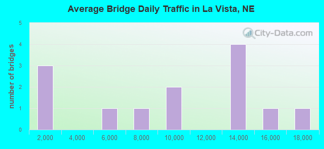
- 114,150Total average daily traffic
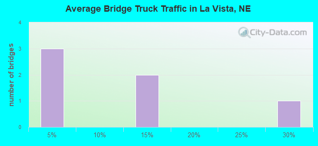
- 2,193Total average daily truck traffic
- National Bridge Inventory (NBI) Registered Bridges for La Vista
- No street view available for this location
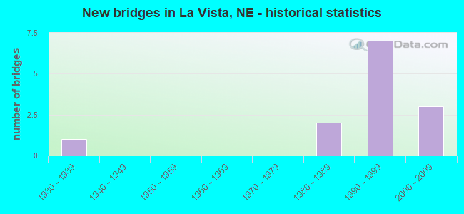
- New bridges - historical statistics
- 11930-1939
- 21980-1989
- 71990-1999
- 32000-2009
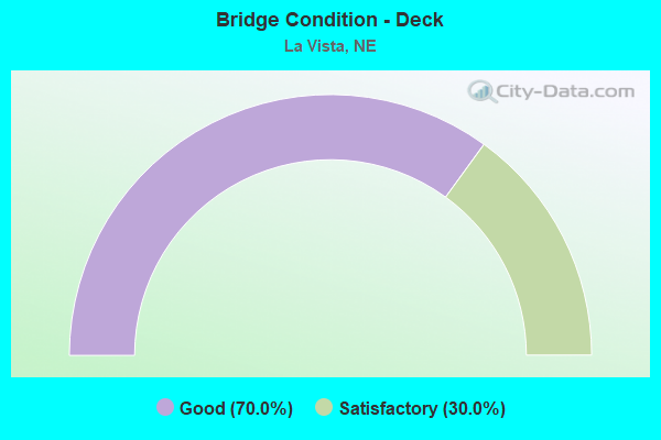
- Bridge Condition - Deck
- 70.0%Good
- 30.0%Satisfactory
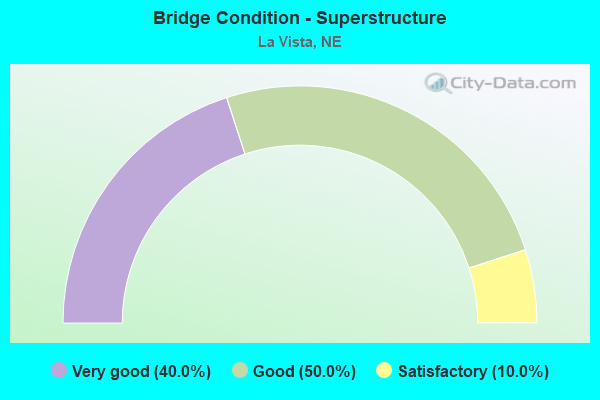
- Bridge Condition - Superstructure
- 40.0%Very good
- 50.0%Good
- 10.0%Satisfactory
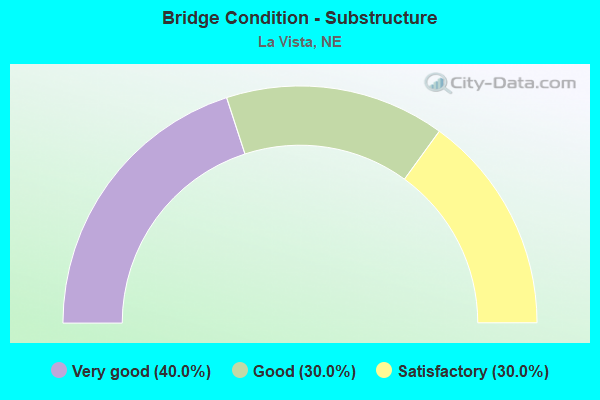
- Bridge Condition - Substructure
- 40.0%Very good
- 30.0%Good
- 30.0%Satisfactory
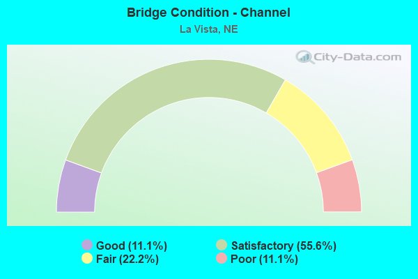
- Bridge Condition - Channel
- 11.1%Good
- 55.6%Satisfactory
- 22.2%Fair
- 11.1%Poor
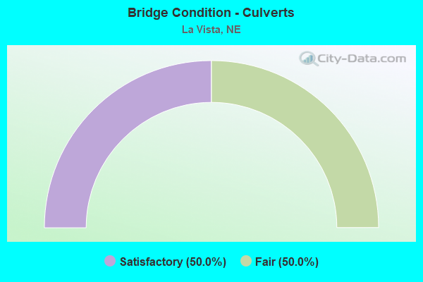
- Bridge Condition - Culverts
- 50.0%Satisfactory
- 50.0%Fair
Find on map >> Show street view
Structure Number: C007702315, Location: .5N 4W OF PAPILLION (Lat: 41.175800, Lng: -96.119600), Route carried "on" structure: County highway 3789, Year Built: 1991, Status: Open, Structure Length: 5.00m (16.40ft), Average Daily Traffic: 8,200 (year 2009), Average Future Daily Traffic: 8,200 (year 2033), Design Load: HS 20, Features Intersected: W BR PAPILLION CREEK
Minimum Vertical Clearance: 30+ m (98+ ft), Kilometerpoint: 0.024, Lanes on structure: 2, Owner: County Highway Agency, Approaching Roadway Width: 7.6m (24.9ft), Skew: 2 degrees, Material/Design: Prestressed concrete, Design/Construction: Stringer/Multi-beam, Number Of Spans In Main Unit: 3, Length of Maximum Span: 16.8m (55.1ft), Curb-To-Curb Width: 12.2m (40.0ft), Out-to-Out Width: 12.9m (42.3ft)
Condition: Deck: Satisfactory, Superstructure: Very good, Substructure: Very good, Channel: Satisfactory, Operating Rating: 71.0 metric tons, Method Used To Determine Operating Rating: Load Factor (LF), Inventory Rating: 42.0 metric tons, Method Used To Determine Inventory Rating: Load Factor (LF), Structural Evaluation: Equal to present desirable criteria, Deck Geometry: Somewhat better than minimum adequacy, Waterway Adequacy: Equal to present desirable criteria, Approach Roadway Alignment: Somewhat better than minimum adequacy, Designated Inspection Frequency: Every 24 months, Inspection Date: August 2020, Deck Structure Type: Concrete Cast-file-Place, Wearing Surface/Protective System: Wearing Surface: Monolithic Concrete, Deck Protection: Epoxy Coated Reinforcing
Find on map >> Show street view
Structure Number: C007723320P, Location: .2E LA VISTA (Lat: 41.183500, Lng: -96.014000), Route carried "on" structure: County highway P233, Year Built: 1935, Year Reconstructed: 1996, Status: Posted for load, Structure Length: 0.98m (3.22ft), Average Daily Traffic: 245 (year 2003), Truck Traffic: 10%, Average Future Daily Traffic: 416 (year 2033), Features Intersected: BIG PAPILLION CREEK TRIB, Facility Carried by Structure: 66TH STREET
Minimum Vertical Clearance: 30+ m (98+ ft), Kilometerpoint: 0.000, Lanes on structure: 2, Owner: County Highway Agency, Approaching Roadway Width: 9.1m (29.9ft), Material/Design: Steel, Design/Construction: Stringer/Multi-beam, Number Of Spans In Main Unit: 2, Length of Maximum Span: 4.9m (16.1ft), Curb-To-Curb Width: 9.1m (29.9ft), Out-to-Out Width: 10.1m (33.1ft)
Condition: Deck: Satisfactory, Superstructure: Satisfactory, Substructure: Satisfactory, Channel: Satisfactory, Operating Rating: 31.0 metric tons, Method Used To Determine Operating Rating: Load Factor (LF), Inventory Rating: 18.0 metric tons, Method Used To Determine Inventory Rating: Load Factor (LF), Structural Evaluation: Somewhat better than minimum adequacy, Deck Geometry: Equal to present minimum criteria, Waterway Adequacy: Somewhat better than minimum adequacy, Approach Roadway Alignment: Better than present minimum criteria, Bridge Posting: Required (Relationship of Operating Rating to Maximum Legal Load: 0.1 - 9.9% below), Designated Inspection Frequency: Every 24 months, Inspection Date: Febuary 2022, Deck Structure Type: Concrete Cast-file-Place, Wearing Surface/Protective System: Wearing Surface: Monolithic Concrete
Find on map >> Show street view
Structure Number: U138300205P, Location: HARRISON @ EASTPORT PKWY (Lat: 41.188400, Lng: -96.083333), Route carried "on" structure: County highway 5022, Year Built: 1989, Status: Open, Structure Length: 14.69m (48.20ft), Average Daily Traffic: 16,425 (year 2010), Average Future Daily Traffic: 18,250 (year 2033), Design Load: HS 20, Features Intersected: EASTPORT PKWY/W PAP CR, Facility Carried by Structure: HARRISON ST
Minimum Vertical Clearance: 30+ m (98+ ft), Kilometerpoint: 16.592, Lanes on structure: 4, Lanes under structure: 2, Base Highway Network: Yes, Owner: City or Municipal Highway Agency, Approaching Roadway Width: 15.8m (51.8ft), Skew: 20 degrees, Material/Design: Prestressed concrete, Design/Construction: Stringer/Multi-beam, Number Of Spans In Main Unit: 5, Length of Maximum Span: 29.3m (96.1ft), Curb or Sidewalk Widths: Left: 1.7m (5.6ft), Right: 0.4m (1.3ft), Curb-To-Curb Width: 15.8m (51.8ft), Out-to-Out Width: 19.9m (65.3ft)
Condition: Deck: Good, Superstructure: Good, Substructure: Satisfactory, Channel: Satisfactory, Operating Rating: 33.0 metric tons, Method Used To Determine Operating Rating: Field evaluation and documented engineering judgment, Inventory Rating: 22.0 metric tons, Method Used To Determine Inventory Rating: Field evaluation and documented engineering judgment, Structural Evaluation: Somewhat better than minimum adequacy, Deck Geometry: Meets minimum limits, Underclear: Superior to present desirable criteria, Waterway Adequacy: Equal to present desirable criteria, Approach Roadway Alignment: Superior to present desirable criteria, Length Of Structure Improvement: 14.69m (48.20ft), Designated Inspection Frequency: Every 24 months, Inspection Date: October 2020, Deck Structure Type: Concrete Cast-file-Place, Wearing Surface/Protective System: Wearing Surface: Monolithic Concrete, Deck Protection: Epoxy Coated Reinforcing
Find on map >> Show street view
Structure Number: U138312515, Location: .1N 2.6W PAPILLION (Lat: 41.174100, Lng: -96.100500), Route carried "on" structure: City street 125, Year Built: 2000, Status: Open, Structure Length: 5.06m (16.60ft), Average Daily Traffic: 50 (year 2003), Average Future Daily Traffic: 85 (year 2033), Design Load: HS 20, Features Intersected: PAPILLION CREEK S BRANCH, Facility Carried by Structure: 120TH STREET
Minimum Vertical Clearance: 30+ m (98+ ft), Kilometerpoint: 0.000, Lanes on structure: 2, Owner: County Highway Agency, Approaching Roadway Width: 7.3m (24.0ft), Skew: 3 degrees, Material/Design: Prestressed concrete continuous, Design/Construction: Stringer/Multi-beam, Number Of Spans In Main Unit: 3, Length of Maximum Span: 18.9m (62.0ft), Curb or Sidewalk Widths: Left: 0.0m, Right: 2.8m (9.2ft), Curb-To-Curb Width: 9.1m (29.9ft), Out-to-Out Width: 12.9m (42.3ft)
Condition: Deck: Good, Superstructure: Good, Substructure: Good, Channel: Fair, Operating Rating: 59.0 metric tons, Method Used To Determine Operating Rating: Load Factor (LF), Inventory Rating: 35.0 metric tons, Method Used To Determine Inventory Rating: Load Factor (LF), Structural Evaluation: Better than present minimum criteria, Deck Geometry: Better than present minimum criteria, Waterway Adequacy: Equal to present desirable criteria, Approach Roadway Alignment: Equal to present desirable criteria, Length Of Structure Improvement: 4.33m (14.21ft), Designated Inspection Frequency: Every 24 months, Inspection Date: December 2020, Deck Structure Type: Concrete Cast-file-Place, Wearing Surface/Protective System: Wearing Surface: Monolithic Concrete, Deck Protection: Epoxy Coated Reinforcing
Find on map >> Show street view
Structure Number: U138320425, Location: WEST GILES RD @ 130TH (Lat: 41.176100, Lng: -96.115400), Route carried "on" structure: City street 3788, Year Built: 1992, Status: Open, Structure Length: 1.13m (3.71ft), Average Daily Traffic: 8,200 (year 2009), Average Future Daily Traffic: 8,200 (year 2033), Design Load: HS 20, Features Intersected: SOUTH PAPILLION CR TRIB, Facility Carried by Structure: GILES RD
Minimum Vertical Clearance: 30+ m (98+ ft), Kilometerpoint: 0.058, Lanes on structure: 2, Owner: City or Municipal Highway Agency, Approaching Roadway Width: 12.2m (40.0ft), Skew: 7 degrees, Material/Design: Concrete, Design/Construction: Culvert, Number Of Spans In Main Unit: 2, Length of Maximum Span: 1.8m (5.9ft)
Condition: Channel: Poor, Culverts: Fair, Operating Rating: 33.0 metric tons, Method Used To Determine Operating Rating: Field evaluation and documented engineering judgment, Inventory Rating: 22.0 metric tons, Method Used To Determine Inventory Rating: Field evaluation and documented engineering judgment, Structural Evaluation: Somewhat better than minimum adequacy, Waterway Adequacy: Better than present minimum criteria, Approach Roadway Alignment: Equal to present desirable criteria, Designated Inspection Frequency: Every 24 months, Inspection Date: October 2020
Find on map >> Show street view
Structure Number: U138320428, Location: GILES RD @ 120TH (Lat: 41.177300, Lng: -96.100600), Route carried "on" structure: City street 3790, Year Built: 1995, Status: Open, Structure Length: 5.27m (17.29ft), Average Daily Traffic: 14,985 (year 2012), Average Future Daily Traffic: 14,985 (year 2033), Design Load: HS 20, Features Intersected: BNSF RR, Facility Carried by Structure: GILES RD
Minimum Vertical Clearance: 30+ m (98+ ft), Kilometerpoint: 0.217, Lanes on structure: 4, Owner: City or Municipal Highway Agency, Approaching Roadway Width: 19.5m (64.0ft), Skew: 22 degrees, Material/Design: Prestressed concrete, Design/Construction: Stringer/Multi-beam, Number Of Spans In Main Unit: 3, Length of Maximum Span: 19.5m (64.0ft), Curb-To-Curb Width: 19.8m (65.0ft), Out-to-Out Width: 25.8m (84.6ft)
Condition: Deck: Good, Superstructure: Very good, Substructure: Very good, Operating Rating: 83.0 metric tons, Method Used To Determine Operating Rating: Load Factor (LF), Inventory Rating: 50.0 metric tons, Method Used To Determine Inventory Rating: Load Factor (LF), Structural Evaluation: Equal to present desirable criteria, Deck Geometry: Better than present minimum criteria, Underclear: Superior to present desirable criteria, Approach Roadway Alignment: Equal to present desirable criteria, Designated Inspection Frequency: Every 24 months, Inspection Date: October 2020, Deck Structure Type: Concrete Cast-file-Place, Wearing Surface/Protective System: Wearing Surface: Monolithic Concrete, Deck Protection: Epoxy Coated Reinforcing
Find on map >> Show street view
Structure Number: U13832043, Location: LAVISTA GILES RD @ 117TH (Lat: 41.176700, Lng: -96.096500), Route carried "on" structure: City street 5012, Year Built: 1995, Status: Open, Structure Length: 6.95m (22.80ft), Average Daily Traffic: 13,230 (year 2010), Truck Traffic: 4%, Average Future Daily Traffic: 14,700 (year 2033), Design Load: HS 20, Features Intersected: PAPILLION CREEK S BRANCH, Facility Carried by Structure: GILES RD
Minimum Vertical Clearance: 30+ m (98+ ft), Kilometerpoint: 16.425, Lanes on structure: 4, Owner: City or Municipal Highway Agency, Approaching Roadway Width: 19.5m (64.0ft), Skew: 23 degrees, Material/Design: Prestressed concrete continuous, Design/Construction: Stringer/Multi-beam, Number Of Spans In Main Unit: 3, Length of Maximum Span: 22.9m (75.1ft), Curb-To-Curb Width: 19.8m (65.0ft), Out-to-Out Width: 25.8m (84.6ft)
Condition: Deck: Satisfactory, Superstructure: Good, Substructure: Very good, Channel: Fair, Operating Rating: 60.0 metric tons, Method Used To Determine Operating Rating: Load Factor (LF), Inventory Rating: 36.0 metric tons, Method Used To Determine Inventory Rating: Load Factor (LF), Structural Evaluation: Better than present minimum criteria, Deck Geometry: Better than present minimum criteria, Waterway Adequacy: Equal to present desirable criteria, Approach Roadway Alignment: Equal to present desirable criteria, Designated Inspection Frequency: Every 24 months, Inspection Date: October 2020, Deck Structure Type: Concrete Cast-file-Place, Wearing Surface/Protective System: Wearing Surface: Monolithic Concrete, Deck Protection: Epoxy Coated Reinforcing
Find on map >> Show street view
Structure Number: U138320435, Location: LAVISTA GILES RD @ 109TH (Lat: 41.176300, Lng: -96.084400), Route carried "on" structure: City street 5012, Year Built: 1994, Status: Open, Structure Length: 6.49m (21.29ft), Average Daily Traffic: 13,230 (year 2010), Truck Traffic: 4%, Average Future Daily Traffic: 14,700 (year 2033), Design Load: HS 20, Features Intersected: PAPILLION CREEK, Facility Carried by Structure: GILES RD
Minimum Vertical Clearance: 30+ m (98+ ft), Kilometerpoint: 16.526, Lanes on structure: 4, Owner: City or Municipal Highway Agency, Approaching Roadway Width: 19.5m (64.0ft), Skew: 22 degrees, Material/Design: Prestressed concrete continuous, Design/Construction: Stringer/Multi-beam, Number Of Spans In Main Unit: 3, Length of Maximum Span: 21.3m (69.9ft), Curb-To-Curb Width: 19.8m (65.0ft), Out-to-Out Width: 25.8m (84.6ft)
Condition: Deck: Good, Superstructure: Very good, Substructure: Very good, Channel: Good, Operating Rating: 66.0 metric tons, Method Used To Determine Operating Rating: Load Factor (LF), Inventory Rating: 39.0 metric tons, Method Used To Determine Inventory Rating: Load Factor (LF), Structural Evaluation: Equal to present desirable criteria, Deck Geometry: Better than present minimum criteria, Waterway Adequacy: Equal to present desirable criteria, Approach Roadway Alignment: Equal to present desirable criteria, Designated Inspection Frequency: Every 24 months, Inspection Date: October 2020, Deck Structure Type: Concrete Cast-file-Place, Wearing Surface/Protective System: Wearing Surface: Integral Concrete, Deck Protection: Epoxy Coated Reinforcing
Find on map >> Show street view
Structure Number: U138320437, Location: LAVISTA GILES RD @ 108TH (Lat: 41.176300, Lng: -96.081100), Route carried "on" structure: City street 5012, Year Built: 1992, Status: Open, Structure Length: 0.64m (2.10ft), Average Daily Traffic: 13,230 (year 2010), Truck Traffic: 4%, Average Future Daily Traffic: 14,700 (year 2033), Design Load: HS 20, Features Intersected: STREAM, Facility Carried by Structure: GILES RD
Minimum Vertical Clearance: 30+ m (98+ ft), Kilometerpoint: 16.555, Lanes on structure: 4, Owner: City or Municipal Highway Agency, Approaching Roadway Width: 19.5m (64.0ft), Skew: 3 degrees, Material/Design: Concrete, Design/Construction: Culvert, Number Of Spans In Main Unit: 2, Length of Maximum Span: 2.7m (8.9ft), Curb-To-Curb Width: 19.5m (64.0ft), Out-to-Out Width: 25.0m (82.0ft)
Condition: Channel: Satisfactory, Culverts: Satisfactory, Operating Rating: 33.0 metric tons, Method Used To Determine Operating Rating: Field evaluation and documented engineering judgment, Inventory Rating: 22.0 metric tons, Method Used To Determine Inventory Rating: Field evaluation and documented engineering judgment, Structural Evaluation: Somewhat better than minimum adequacy, Deck Geometry: Better than present minimum criteria, Waterway Adequacy: Better than present minimum criteria, Approach Roadway Alignment: Equal to present desirable criteria, Designated Inspection Frequency: Every 24 months, Inspection Date: October 2020
Find on map >> Show street view
Structure Number: U13832244, Location: HARRISON HILLS SUBDIV (Lat: 41.186700, Lng: -96.089300), Route carried "on" structure: City street , Year Built: 2002, Status: Open, Structure Length: 3.78m (12.40ft), Average Daily Traffic: 330 (year 2004), Truck Traffic: 25%, Average Future Daily Traffic: 220 (year 2033), Design Load: HS 20, Features Intersected: HELL CREEK, Facility Carried by Structure: OLIVE ROAD
Minimum Vertical Clearance: 30+ m (98+ ft), Kilometerpoint: 0.000, Lanes on structure: 2, Owner: City or Municipal Highway Agency, Approaching Roadway Width: 9.1m (29.9ft), Skew: 2 degrees, Material/Design: Prestressed concrete, Design/Construction: Tee Beam, Number Of Spans In Main Unit: 3, Length of Maximum Span: 14.6m (47.9ft), Curb or Sidewalk Widths: Left: 1.5m (4.9ft), Right: 0.0m, Curb-To-Curb Width: 9.2m (30.2ft), Out-to-Out Width: 11.8m (38.7ft)
Condition: Deck: Good, Superstructure: Good, Substructure: Satisfactory, Channel: Satisfactory, Operating Rating: 68.0 metric tons, Method Used To Determine Operating Rating: Load Factor (LF), Inventory Rating: 41.0 metric tons, Method Used To Determine Inventory Rating: Load Factor (LF), Structural Evaluation: Equal to present minimum criteria, Deck Geometry: Equal to present minimum criteria, Waterway Adequacy: Equal to present desirable criteria, Approach Roadway Alignment: Equal to present desirable criteria, Designated Inspection Frequency: Every 24 months, Inspection Date: October 2020, Deck Structure Type: Concrete Cast-file-Place, Wearing Surface/Protective System: Wearing Surface: Monolithic Concrete, Deck Protection: Epoxy Coated Reinforcing
Find on map >> Show street view
Structure Number: U13833292, Location: .5W OF LA VISTA (Lat: 41.188200, Lng: -96.061900), Route carried "on" structure: City street 3793, Year Built: 1995, Status: Open, Structure Length: 5.18m (16.99ft), Average Daily Traffic: 13,150 (year 2007), Average Future Daily Traffic: 22,355 (year 2033), Design Load: HS 20, Features Intersected: BNSF RR, Facility Carried by Structure: 96TH ST
Minimum Vertical Clearance: 30+ m (98+ ft), Kilometerpoint: 0.705, Lanes on structure: 4, Owner: City or Municipal Highway Agency, Approaching Roadway Width: 14.6m (47.9ft), Skew: 23 degrees, Material/Design: Prestressed concrete, Design/Construction: Tee Beam, Number Of Spans In Main Unit: 3, Length of Maximum Span: 18.9m (62.0ft), Curb or Sidewalk Widths: Left: 1.5m (4.9ft), Right: 1.5m (4.9ft), Curb-To-Curb Width: 14.6m (47.9ft), Out-to-Out Width: 24.6m (80.7ft)
Condition: Deck: Good, Superstructure: Good, Substructure: Good, Operating Rating: 33.0 metric tons, Method Used To Determine Operating Rating: Field evaluation and documented engineering judgment, Inventory Rating: 22.0 metric tons, Method Used To Determine Inventory Rating: Field evaluation and documented engineering judgment, Structural Evaluation: Somewhat better than minimum adequacy, Deck Geometry: High priority of replacement, Underclear: Superior to present desirable criteria, Approach Roadway Alignment: Equal to present desirable criteria, Designated Inspection Frequency: Every 24 months, Inspection Date: October 2020, Deck Structure Type: Concrete Cast-file-Place, Wearing Surface/Protective System: Wearing Surface: Monolithic Concrete, Deck Protection: Epoxy Coated Reinforcing
Find on map >> Show street view
Structure Number: U138342715P, Location: 2W.7S HWY85 DOUGCO LINE (Lat: 41.182400, Lng: -96.081600), Route carried "on" structure: City street 5011, Year Built: 2003, Status: Open, Structure Length: 6.10m (20.01ft), Average Daily Traffic: 7,875 (year 2010), Average Future Daily Traffic: 12,300 (year 2033), Design Load: HS 20, Features Intersected: BNRR, Facility Carried by Structure: 108TH ST
Minimum Vertical Clearance: 30+ m (98+ ft), Kilometerpoint: 15.932, Lanes on structure: 4, Owner: City or Municipal Highway Agency, Approaching Roadway Width: 14.6m (47.9ft), Skew: 23 degrees, Material/Design: Prestressed concrete continuous, Design/Construction: Stringer/Multi-beam, Number Of Spans In Main Unit: 3, Length of Maximum Span: 29.3m (96.1ft), Curb or Sidewalk Widths: Left: 1.7m (5.6ft), Right: 1.7m (5.6ft), Curb-To-Curb Width: 14.6m (47.9ft), Out-to-Out Width: 24.6m (80.7ft)
Condition: Deck: Good, Superstructure: Very good, Substructure: Good, Operating Rating: 73.0 metric tons, Method Used To Determine Operating Rating: Load Factor (LF), Inventory Rating: 41.0 metric tons, Method Used To Determine Inventory Rating: Load Factor (LF), Structural Evaluation: Better than present minimum criteria, Deck Geometry: High priority of replacement, Underclear: Superior to present desirable criteria, Approach Roadway Alignment: Equal to present desirable criteria, Designated Inspection Frequency: Every 24 months, Inspection Date: October 2020, Deck Structure Type: Concrete Cast-file-Place, Wearing Surface/Protective System: Wearing Surface: Monolithic Concrete, Deck Protection: Epoxy Coated Reinforcing
Find on map >> Show street view
Structure Number: U138300205P, Location: HARRISON @ EASTPORT PKWY (Lat: 41.188400, Lng: -96.083333), Route carried "under" structure: County highway 25, Year Built: 1989, Structure Length: 0. m, Average Daily Traffic: 5,000 (year 1997), Truck Traffic: 10%, Features Intersected: EASTPORT PKWY/W PAP CR, Facility Carried by Structure: HARRISON ST
Minimum Vertical Clearance: 6.95m (22.80ft), Kilometerpoint: 0.000, Lanes on structure: 2, Lanes under structure: 2, Material/Design: Prestressed concrete, Design/Construction: Stringer/Multi-beam, Length of Maximum Span: 29.3m (96.1ft)