Bridge Statistics for Key Largo, Florida (FL)
Condition, Traffic, Stress, Structural Evaluation, Project Costs
- National Bridge Inventory (NBI) Statistics
- 14Number of bridges
- 1,145ft / 349mTotal length
- 63,470Total average daily traffic
- 6,177Total average daily truck traffic
- 106,240Total future (year 2039) average daily traffic
- National Bridge Inventory (NBI) Registered Bridges for Key Largo
- No street view available for this location
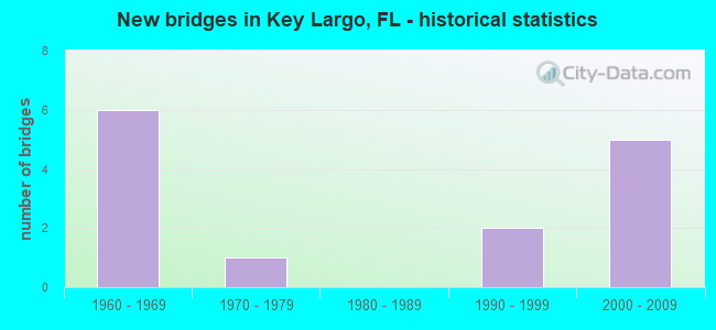
- New bridges - historical statistics
- 61960-1969
- 11970-1979
- 21990-1999
- 52000-2009

- Reconstructed bridges - Historical Statistics
- 11970-1979
- 11980-1989
- 01990-1999
- 12000-2009


- Bridge Condition - Deck
- 35.7%Very good
- 35.7%Good
- 7.1%Satisfactory
- 7.1%Fair
- 14.3%Serious

- Bridge Condition - Superstructure
- 7.1%Excellent
- 28.6%Very good
- 21.4%Good
- 14.3%Satisfactory
- 14.3%Fair
- 14.3%Serious

- Bridge Condition - Substructure
- 7.1%Excellent
- 42.9%Very good
- 21.4%Good
- 21.4%Satisfactory
- 7.1%Fair

- Bridge Condition - Channel
- 23.1%Excellent
- 38.5%Very good
- 15.4%Good
- 15.4%Satisfactory
- 7.7%Fair
Find on map >> Show street view
Structure Number: 900073, Location: KEY LARGO (MM 103.6) (Lat: 25.137669, Lng: -80.402208), Route carried "on" structure: US 1, Year Built: 1973, Year Reconstructed: 1993, Status: Open, Structure Length: 3.63m (11.91ft), Average Daily Traffic: 12,789 (year 2020), Truck Traffic: 11%, Average Future Daily Traffic: 22,189 (year 2042), Design Load: HS 20, Features Intersected: MARVIN D. ADAMS WATERWAY
Minimum Vertical Clearance: 30+ m (98+ ft), Kilometerpoint: 47.664, Lanes on structure: 2, Base Highway Network: Yes, Owner: State Highway Agency, Approaching Roadway Width: 12.2m (40.0ft), Skew: 2 degrees, Material/Design: Prestressed concrete, Design/Construction: Stringer/Multi-beam, Number Of Spans In Main Unit: 1, Length of Maximum Span: 36.3m (119.1ft), Curb-To-Curb Width: 12.2m (40.0ft), Out-to-Out Width: 13.0m (42.7ft)
Condition: Deck: Good, Superstructure: Very good, Substructure: Very good, Channel: Very good, Inventory Rating: 37.4 metric tons, Method Used To Determine Inventory Rating: Load Factor (LF), Structural Evaluation: Equal to present desirable criteria, Deck Geometry: Better than present minimum criteria, Waterway Adequacy: Equal to present desirable criteria, Approach Roadway Alignment: Equal to present desirable criteria, Designated Inspection Frequency: Every 24 months, Inspection Date: September 2020, Deck Structure Type: Concrete Cast-file-Place, Wearing Surface/Protective System: Wearing Surface: Integral Concrete
Find on map >> Show street view
Structure Number: 90013, Location: KEY LARGO (MM 103.6) (Lat: 25.137717, Lng: -80.402425), Route carried "on" structure: US 1, Year Built: 1993, Status: Open, Structure Length: 3.54m (11.61ft), Average Daily Traffic: 12,789 (year 2020), Truck Traffic: 11%, Average Future Daily Traffic: 22,189 (year 2042), Design Load: HS 20, Features Intersected: MARVIN D. ADAMS WATERWAY
Minimum Vertical Clearance: 30+ m (98+ ft), Kilometerpoint: 47.664, Lanes on structure: 2, Base Highway Network: Yes, Owner: State Highway Agency, Approaching Roadway Width: 12.2m (40.0ft), Skew: 2 degrees, Material/Design: Prestressed concrete, Design/Construction: Stringer/Multi-beam, Number Of Spans In Main Unit: 1, Length of Maximum Span: 35.4m (116.1ft), Curb-To-Curb Width: 12.2m (40.0ft), Out-to-Out Width: 13.0m (42.7ft)
Condition: Deck: Good, Superstructure: Good, Substructure: Very good, Channel: Very good, Inventory Rating: 40.6 metric tons, Method Used To Determine Inventory Rating: Load Factor (LF), Structural Evaluation: Better than present minimum criteria, Deck Geometry: Better than present minimum criteria, Waterway Adequacy: Equal to present desirable criteria, Approach Roadway Alignment: Equal to present desirable criteria, Designated Inspection Frequency: Every 24 months, Inspection Date: September 2020, Deck Structure Type: Concrete Cast-file-Place, Wearing Surface/Protective System: Wearing Surface: Integral Concrete
Find on map >> Show street view
Structure Number: 900131, Location: US 1 (M.M. 107) (Lat: 25.181361, Lng: -80.383386), Route carried "on" structure: US 1, Year Built: 2008, Status: Open, Structure Length: 228.91m (751.02ft), Average Daily Traffic: 22,500 (year 2020), Truck Traffic: 13%, Average Future Daily Traffic: 39,038 (year 2042), Design Load: HL 93, Features Intersected: JEWFISH CREEK
Minimum Vertical Clearance: 30+ m (98+ ft), Kilometerpoint: 52.986, Lanes on structure: 2, Base Highway Network: Yes, Owner: State Highway Agency, Approaching Roadway Width: 7.6m (24.9ft), Skew: 30 degrees, Navigation Control: Yes ( Vertical Clearance: 19.8m (65.0ft), Horizontal Clearance: 27.4m (89.9ft)), Material/Design: Prestressed concrete, Design/Construction: Stringer/Multi-beam, Number Of Spans In Main Unit: 68, Length of Maximum Span: 48.8m (160.1ft), Curb-To-Curb Width: 7.6m (24.9ft), Out-to-Out Width: 17.7m (58.1ft)
Condition: Deck: Very good, Superstructure: Good, Substructure: Very good, Channel: Good, Operating Rating: 60.8 metric tons, Method Used To Determine Operating Rating: Load and Resistance Factor (LRFR), Inventory Rating: 47.0 metric tons, Method Used To Determine Inventory Rating: Load and Resistance Factor (LRFR), Structural Evaluation: Better than present minimum criteria, Deck Geometry: High priority of replacement, Waterway Adequacy: Superior to present desirable criteria, Approach Roadway Alignment: Equal to present desirable criteria, Designated Inspection Frequency: Every 24 months, Underwater Inspection Frequency: Every 24 months, Inspection Date: July 2020, Underwater Inspection Date: July 2020, Deck Structure Type: Concrete Cast-file-Place, Wearing Surface/Protective System: Wearing Surface: Integral Concrete
Find on map >> Show street view
Structure Number: 900132, Location: SB ON RAMP TO US-1 (Lat: 25.180386, Lng: -80.382267), Route carried "on" structure: Ramp US 1, Year Built: 2008, Status: Open, Structure Length: 23.77m (77.99ft), Average Daily Traffic: 150 (year 2020), Truck Traffic: 10%, Average Future Daily Traffic: 260 (year 2042), Design Load: HL 93, Features Intersected: JEWFISH CREEK
Minimum Vertical Clearance: 30.45m (99.90ft), Kilometerpoint: 0.000, Lanes on structure: 1, Owner: State Highway Agency, Approaching Roadway Width: 8.1m (26.6ft), Material/Design: Prestressed concrete, Design/Construction: Stringer/Multi-beam, Number Of Spans In Main Unit: 6, Number Of Approach Spans: 3, Length of Maximum Span: 33.0m (108.3ft), Curb-To-Curb Width: 8.1m (26.6ft), Out-to-Out Width: 9.2m (30.2ft)
Condition: Deck: Very good, Superstructure: Very good, Substructure: Very good, Channel: Excellent, Operating Rating: 47.6 metric tons, Method Used To Determine Operating Rating: Load and Resistance Factor (LRFR), Inventory Rating: 43.4 metric tons, Method Used To Determine Inventory Rating: Load and Resistance Factor (LRFR), Structural Evaluation: Equal to present desirable criteria, Deck Geometry: Superior to present desirable criteria, Waterway Adequacy: Equal to present desirable criteria, Approach Roadway Alignment: Equal to present desirable criteria, Designated Inspection Frequency: Every 24 months, Underwater Inspection Frequency: Every 24 months, Inspection Date: July 2020, Underwater Inspection Date: July 2020, Deck Structure Type: Concrete Cast-file-Place, Wearing Surface/Protective System: Wearing Surface: Integral Concrete
Find on map >> Show street view
Structure Number: 900133, Location: NB OFF RAMP TO ROTARY (Lat: 25.180636, Lng: -80.382044), Route carried "on" structure: Ramp US 1, Year Built: 2008, Status: Open, Structure Length: 23.77m (77.99ft), Average Daily Traffic: 150 (year 2020), Truck Traffic: 23%, Average Future Daily Traffic: 260 (year 2042), Design Load: HL 93, Features Intersected: JEWFISH CREEK
Minimum Vertical Clearance: 30+ m (98+ ft), Kilometerpoint: 0.013, Lanes on structure: 1, Owner: State Highway Agency, Approaching Roadway Width: 8.2m (26.9ft), Material/Design: Prestressed concrete, Design/Construction: Stringer/Multi-beam, Number Of Spans In Main Unit: 6, Number Of Approach Spans: 3, Length of Maximum Span: 33.0m (108.3ft), Curb-To-Curb Width: 8.2m (26.9ft), Out-to-Out Width: 9.2m (30.2ft)
Condition: Deck: Very good, Superstructure: Very good, Substructure: Very good, Channel: Excellent, Operating Rating: 51.6 metric tons, Method Used To Determine Operating Rating: Load and Resistance Factor (LRFR), Inventory Rating: 39.6 metric tons, Method Used To Determine Inventory Rating: Load and Resistance Factor (LRFR), Structural Evaluation: Equal to present desirable criteria, Deck Geometry: Superior to present desirable criteria, Waterway Adequacy: Equal to present desirable criteria, Approach Roadway Alignment: Meets minimum limits, Designated Inspection Frequency: Every 24 months, Underwater Inspection Frequency: Every 24 months, Inspection Date: July 2020, Underwater Inspection Date: July 2020, Deck Structure Type: Concrete Cast-file-Place, Wearing Surface/Protective System: Wearing Surface: Integral Concrete
Find on map >> Show street view
Structure Number: 900134, Location: NB OFF RAMP TO US-1 (Lat: 25.182036, Lng: -80.384028), Route carried "on" structure: Ramp US 1, Year Built: 2008, Status: Open, Structure Length: 25.63m (84.09ft), Average Daily Traffic: 90 (year 2020), Truck Traffic: 4%, Average Future Daily Traffic: 156 (year 2042), Design Load: HL 93, Features Intersected: JEWFISH CREEK
Minimum Vertical Clearance: 30+ m (98+ ft), Kilometerpoint: 0.000, Lanes on structure: 1, Owner: State Highway Agency, Approaching Roadway Width: 8.2m (26.9ft), Material/Design: Prestressed concrete, Design/Construction: Stringer/Multi-beam, Number Of Spans In Main Unit: 7, Number Of Approach Spans: 3, Length of Maximum Span: 31.3m (102.7ft), Curb-To-Curb Width: 8.2m (26.9ft), Out-to-Out Width: 9.2m (30.2ft)
Condition: Deck: Very good, Superstructure: Very good, Substructure: Good, Channel: Excellent, Operating Rating: 51.0 metric tons, Method Used To Determine Operating Rating: Load and Resistance Factor (LRFR), Inventory Rating: 39.6 metric tons, Method Used To Determine Inventory Rating: Load and Resistance Factor (LRFR), Structural Evaluation: Better than present minimum criteria, Deck Geometry: Superior to present desirable criteria, Waterway Adequacy: Equal to present desirable criteria, Approach Roadway Alignment: Equal to present desirable criteria, Designated Inspection Frequency: Every 24 months, Underwater Inspection Frequency: Every 24 months, Inspection Date: July 2020, Underwater Inspection Date: July 2020, Deck Structure Type: Concrete Cast-file-Place, Wearing Surface/Protective System: Wearing Surface: Integral Concrete
Find on map >> Show street view
Structure Number: 900135, Location: SB OFF RAMP TO ROTARY (Lat: 25.181906, Lng: -80.384411), Route carried "on" structure: Ramp US 1, Year Built: 2007, Status: Open, Structure Length: 15.66m (51.38ft), Average Daily Traffic: 70 (year 2020), Truck Traffic: 5%, Average Future Daily Traffic: 121 (year 2042), Design Load: HL 93, Features Intersected: JEWFISH CREEK
Minimum Vertical Clearance: 30+ m (98+ ft), Kilometerpoint: 0.014, Lanes on structure: 1, Owner: State Highway Agency, Approaching Roadway Width: 8.2m (26.9ft), Material/Design: Prestressed concrete, Design/Construction: Stringer/Multi-beam, Number Of Spans In Main Unit: 5, Length of Maximum Span: 31.3m (102.7ft), Curb-To-Curb Width: 8.2m (26.9ft), Out-to-Out Width: 9.2m (30.2ft)
Condition: Deck: Very good, Superstructure: Excellent, Substructure: Excellent, Operating Rating: 56.2 metric tons, Method Used To Determine Operating Rating: Load and Resistance Factor (LRFR), Inventory Rating: 43.5 metric tons, Method Used To Determine Inventory Rating: Load and Resistance Factor (LRFR), Structural Evaluation: Superior to present desirable criteria, Deck Geometry: Superior to present desirable criteria, Waterway Adequacy: Equal to present desirable criteria, Approach Roadway Alignment: Meets minimum limits, Designated Inspection Frequency: Every 24 months, Inspection Date: July 2020, Deck Structure Type: Concrete Cast-file-Place, Wearing Surface/Protective System: Wearing Surface: Integral Concrete
Find on map >> Show street view
Structure Number: 900801, Location: US-1 MM 102 (Lat: 25.124625, Lng: -80.405392), Route carried "on" structure: ServiceState lands road 1, Year Built: 1967, Year Reconstructed: 1978, Status: Open, Structure Length: 2.62m (8.60ft), Average Daily Traffic: 1,869 (year 2020), Average Future Daily Traffic: 3,747 (year 2042), Design Load: HS 20, Features Intersected: Calley Slough, Facility Carried by Structure: Beach Road
Minimum Vertical Clearance: 30+ m (98+ ft), Kilometerpoint: 0.000, Lanes on structure: 2, Toll: On toll road, Owner: State Park, Forest, or Reservation Agency, Approaching Roadway Width: 7.0m (23.0ft), Skew: 1 degrees, Material/Design: Wood or Timber, Design/Construction: Stringer/Multi-beam, Number Of Spans In Main Unit: 5, Length of Maximum Span: 5.2m (17.1ft), Curb or Sidewalk Widths: Left: 2.1m (6.9ft), Right: 0.0m, Curb-To-Curb Width: 6.8m (22.3ft), Out-to-Out Width: 8.3m (27.2ft)
Condition: Deck: Satisfactory, Superstructure: Satisfactory, Substructure: Satisfactory, Channel: Fair, Operating Rating: 58.3 metric tons, Method Used To Determine Operating Rating: Load Factor (LF), Inventory Rating: 32.1 metric tons, Method Used To Determine Inventory Rating: Load Factor (LF), Structural Evaluation: Equal to present minimum criteria, Deck Geometry: High priority of corrective action, Waterway Adequacy: Equal to present minimum criteria, Approach Roadway Alignment: Equal to present minimum criteria, Designated Inspection Frequency: Every 24 months, Underwater Inspection Frequency: Every 24 months, Inspection Date: March 2021, Underwater Inspection Date: March 2021, Deck Structure Type: Wood or Timber, Wearing Surface/Protective System: Wearing Surface: Wood or Timber
Find on map >> Show street view
Structure Number: 904908, Location: 200Ft. E of CR-905 (Lat: 25.194111, Lng: -80.352647), Route carried "on" structure: City street , Year Built: 1995, Status: Open, Structure Length: 1.59m (5.22ft), Average Daily Traffic: 282 (year 2020), Truck Traffic: 2%, Average Future Daily Traffic: 286 (year 2042), Design Load: HS 20, Features Intersected: Canal, Facility Carried by Structure: Valois Blvd.
Minimum Vertical Clearance: 30+ m (98+ ft), Kilometerpoint: 0.000, Lanes on structure: 2, Owner: County Highway Agency, Approaching Roadway Width: 5.9m (19.4ft), Skew: 5 degrees, Material/Design: Prestressed concrete, Design/Construction: Slab, Number Of Spans In Main Unit: 1, Length of Maximum Span: 15.9m (52.2ft), Curb or Sidewalk Widths: Left: 0.2m (0.7ft), Right: 0.2m (0.7ft), Curb-To-Curb Width: 8.2m (26.9ft), Out-to-Out Width: 9.4m (30.8ft)
Condition: Deck: Fair, Superstructure: Fair, Substructure: Satisfactory, Channel: Very good, Operating Rating: 35.6 metric tons, Method Used To Determine Operating Rating: Load Factor (LF), Inventory Rating: 18.5 metric tons, Method Used To Determine Inventory Rating: Load Factor (LF), Structural Evaluation: Somewhat better than minimum adequacy, Deck Geometry: Somewhat better than minimum adequacy, Waterway Adequacy: Better than present minimum criteria, Approach Roadway Alignment: Better than present minimum criteria, Designated Inspection Frequency: Every 24 months, Underwater Inspection Frequency: Every 24 months, Inspection Date: March 2020, Underwater Inspection Date: March 2020, Deck Structure Type: Concrete Precast Panels, Wearing Surface/Protective System: Wearing Surface: Bituminous
Find on map >> Show street view
Structure Number: 90491, Location: 200Ft S/O US1 at MM 98.4 (Lat: 25.081439, Lng: -80.453689), Route carried "on" structure: County highway , Year Built: 1962, Status: Open, Structure Length: 0.73m (2.40ft), Average Daily Traffic: 51 (year 2014), Truck Traffic: 1%, Average Future Daily Traffic: 82 (year 2039), Design Load: HS 20, Features Intersected: Doug's Canal, Facility Carried by Structure: Bahama Road
Minimum Vertical Clearance: 30+ m (98+ ft), Kilometerpoint: 0.000, Lanes on structure: 2, Owner: County Highway Agency, Approaching Roadway Width: 5.2m (17.1ft), Material/Design: Concrete, Design/Construction: Stringer/Multi-beam, Number Of Spans In Main Unit: 1, Length of Maximum Span: 7.3m (24.0ft), Curb-To-Curb Width: 5.5m (18.0ft), Out-to-Out Width: 6.1m (20.0ft)
Condition: Deck: Good, Superstructure: Fair, Substructure: Good, Channel: Very good, Operating Rating: 51.3 metric tons, Method Used To Determine Operating Rating: Load Factor (LF), Inventory Rating: 30.8 metric tons, Method Used To Determine Inventory Rating: Load Factor (LF), Structural Evaluation: Somewhat better than minimum adequacy, Deck Geometry: Meets minimum limits, Waterway Adequacy: Better than present minimum criteria, Approach Roadway Alignment: Equal to present desirable criteria, Designated Inspection Frequency: Every 24 months, Inspection Date: March 2020, Deck Structure Type: Concrete Cast-file-Place, Wearing Surface/Protective System: Wearing Surface: Monolithic Concrete
Find on map >> Show street view
Structure Number: 90498, Location: 1.6 Miles N of CR 905 (Lat: 25.283778, Lng: -80.330250), Route carried "on" structure: County highway 905A, Year Built: 1968, Status: Open, Structure Length: 9.63m (31.59ft), Average Daily Traffic: 3,182 (year 2020), Truck Traffic: 3%, Average Future Daily Traffic: 4,478 (year 2042), Design Load: HS 20, Features Intersected: Steam Boat Creek
Minimum Vertical Clearance: 30+ m (98+ ft), Kilometerpoint: 2.589, Lanes on structure: 2, Toll: On toll road, Owner: County Highway Agency, Approaching Roadway Width: 7.0m (23.0ft), Skew: 3 degrees, Material/Design: Prestressed concrete, Design/Construction: Stringer/Multi-beam, Number Of Spans In Main Unit: 6, Length of Maximum Span: 16.1m (52.8ft), Curb or Sidewalk Widths: Left: 1.3m (4.3ft), Right: 1.3m (4.3ft), Curb-To-Curb Width: 8.5m (27.9ft), Out-to-Out Width: 11.6m (38.1ft)
Condition: Deck: Good, Superstructure: Satisfactory, Substructure: Fair, Channel: Satisfactory, Operating Rating: 52.2 metric tons, Method Used To Determine Operating Rating: Load Factor (LF), Inventory Rating: 27.6 metric tons, Method Used To Determine Inventory Rating: Load Factor (LF), Structural Evaluation: Somewhat better than minimum adequacy, Deck Geometry: Meets minimum limits, Waterway Adequacy: Meets minimum limits, Approach Roadway Alignment: Better than present minimum criteria, Designated Inspection Frequency: Every 24 months, Underwater Inspection Frequency: Every 24 months, Inspection Date: August 2020, Underwater Inspection Date: August 2020, Deck Structure Type: Concrete Cast-file-Place, Wearing Surface/Protective System: Wearing Surface: Bituminous
Find on map >> Show street view
Structure Number: 904982, Location: 3.1 Miles N of CR905 (Lat: 25.279417, Lng: -80.343083), Route carried "on" structure: County highway 905A, Year Built: 1969, Status: Open, Structure Length: 3.08m (10.10ft), Average Daily Traffic: 3,182 (year 2020), Truck Traffic: 3%, Average Future Daily Traffic: 4,478 (year 2042), Design Load: H 20, Features Intersected: Tubbys Creek, Facility Carried by Structure: Card Sound Road
Minimum Vertical Clearance: 30+ m (98+ ft), Kilometerpoint: 6.043, Lanes on structure: 2, Toll: On toll road, Owner: County Highway Agency, Approaching Roadway Width: 7.0m (23.0ft), Material/Design: Prestressed concrete, Design/Construction: Slab, Number Of Spans In Main Unit: 3, Length of Maximum Span: 10.4m (34.1ft), Curb or Sidewalk Widths: Left: 1.3m (4.3ft), Right: 1.2m (3.9ft), Curb-To-Curb Width: 8.5m (27.9ft), Out-to-Out Width: 11.7m (38.4ft)
Condition: Deck: Serious, Superstructure: Serious, Substructure: Good, Channel: Satisfactory, Operating Rating: 44.4 metric tons, Method Used To Determine Operating Rating: Load Factor (LF), Inventory Rating: 26.6 metric tons, Method Used To Determine Inventory Rating: Load Factor (LF), Structural Evaluation: High priority of corrective action, Deck Geometry: Meets minimum limits, Waterway Adequacy: Meets minimum limits, Approach Roadway Alignment: Equal to present desirable criteria, Designated Inspection Frequency: Every 24 months, Underwater Inspection Frequency: Every 24 months, Other Special Inspection Frequency: Every 6 months, Inspection Date: Febuary 2022, Underwater Inspection Date: August 2020, Other Special Inspection Date: August 2021, Deck Structure Type: Concrete Precast Panels, Wearing Surface/Protective System: Wearing Surface: Bituminous
Find on map >> Show street view
Structure Number: 904984, Location: 3.8 Miles N of CR905 (Lat: 25.282639, Lng: -80.354306), Route carried "on" structure: County highway 905A, Year Built: 1969, Status: Open, Structure Length: 3.08m (10.10ft), Average Daily Traffic: 3,182 (year 2020), Truck Traffic: 3%, Average Future Daily Traffic: 4,478 (year 2042), Design Load: H 20, Features Intersected: Mosquito Creek, Facility Carried by Structure: Card Sound Road
Minimum Vertical Clearance: 30+ m (98+ ft), Kilometerpoint: 7.224, Lanes on structure: 2, Toll: On toll road, Owner: County Highway Agency, Approaching Roadway Width: 7.3m (24.0ft), Material/Design: Prestressed concrete, Design/Construction: Slab, Number Of Spans In Main Unit: 3, Length of Maximum Span: 10.3m (33.8ft), Curb or Sidewalk Widths: Left: 1.2m (3.9ft), Right: 1.2m (3.9ft), Curb-To-Curb Width: 8.5m (27.9ft), Out-to-Out Width: 11.6m (38.1ft)
Condition: Deck: Serious, Superstructure: Serious, Substructure: Very good, Channel: Very good, Operating Rating: 33.0 metric tons, Method Used To Determine Operating Rating: Load and Resistance Factor (LRFR), Inventory Rating: 25.5 metric tons, Method Used To Determine Inventory Rating: Load and Resistance Factor (LRFR), Structural Evaluation: High priority of corrective action, Deck Geometry: Meets minimum limits, Waterway Adequacy: Meets minimum limits, Approach Roadway Alignment: Equal to present desirable criteria, Designated Inspection Frequency: Every 24 months, Underwater Inspection Frequency: Every 24 months, Other Special Inspection Frequency: Every 6 months, Inspection Date: Febuary 2022, Underwater Inspection Date: August 2020, Other Special Inspection Date: August 2021, Deck Structure Type: Concrete Precast Panels, Wearing Surface/Protective System: Wearing Surface: Bituminous
Find on map >> Show street view
Structure Number: 904986, Location: 3.5 Miles N of CR 905 (Lat: 25.283828, Lng: -80.358294), Route carried "on" structure: Alternate County highway 905A, Year Built: 1969, Year Reconstructed: 2007, Status: Open, Structure Length: 3.11m (10.20ft), Average Daily Traffic: 3,184 (year 2021), Truck Traffic: 3%, Average Future Daily Traffic: 4,478 (year 2042), Design Load: HS 20, Features Intersected: Saunders Creek
Minimum Vertical Clearance: 30+ m (98+ ft), Kilometerpoint: 7.649, Lanes on structure: 2, Toll: On toll road, Owner: County Highway Agency, Approaching Roadway Width: 7.3m (24.0ft), Material/Design: Prestressed concrete, Design/Construction: Slab, Number Of Spans In Main Unit: 3, Length of Maximum Span: 10.1m (33.1ft), Curb-To-Curb Width: 10.1m (33.1ft), Out-to-Out Width: 11.2m (36.7ft)
Condition: Deck: Good, Superstructure: Good, Substructure: Satisfactory, Channel: Good, Operating Rating: 57.8 metric tons, Method Used To Determine Operating Rating: Load Factor (LF), Inventory Rating: 34.7 metric tons, Method Used To Determine Inventory Rating: Load Factor (LF), Structural Evaluation: Equal to present minimum criteria, Deck Geometry: Meets minimum limits, Waterway Adequacy: Meets minimum limits, Approach Roadway Alignment: Equal to present desirable criteria, Designated Inspection Frequency: Every 24 months, Underwater Inspection Frequency: Every 24 months, Inspection Date: October 2021, Underwater Inspection Date: October 2021, Deck Structure Type: Concrete Precast Panels, Wearing Surface/Protective System: Wearing Surface: Monolithic Concrete