Bridge Statistics for Kenwood, Ohio (OH)
Condition, Traffic, Stress, Structural Evaluation, Project Costs
- National Bridge Inventory (NBI) Statistics
- 15Number of bridges
- 174ft / 52.7mTotal length
- 760,091Total average daily traffic
- 89,765Total average daily truck traffic
- National Bridge Inventory (NBI) Registered Bridges for Kenwood
- No street view available for this location
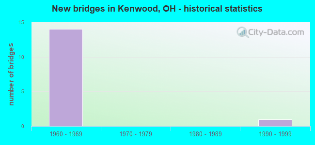
- New bridges - historical statistics
- 141960-1969
- 11990-1999


- Bridge Condition - Deck
- 57.1%Good
- 42.9%Satisfactory

- Bridge Condition - Superstructure
- 85.7%Good
- 14.3%Satisfactory
Find on map >> Show street view
Structure Number: 3100901, Location: .3 MI W OF MADEIRA (Lat: 39.200981, Lng: -84.374700), Route carried "on" structure: US 22, Year Built: 1966, Year Reconstructed: 2005, Status: Open, Structure Length: 10.62m (34.84ft), Average Daily Traffic: 22,752 (year 2015), Truck Traffic: 3%, Average Future Daily Traffic: 31,580 (year 2035), Design Load: HS 20, Features Intersected: I71
Minimum Vertical Clearance: 30+ m (98+ ft), Kilometerpoint: 18.363, Lanes on structure: 6, Lanes under structure: 6, Base Highway Network: Yes, Owner: State Highway Agency, Approaching Roadway Width: 29.9m (98.1ft), Skew: 4 degrees, Material/Design: Steel continuous, Design/Construction: Stringer/Multi-beam, Number Of Spans In Main Unit: 4, Length of Maximum Span: 30.2m (99.1ft), Curb or Sidewalk Widths: Left: 0.0m, Right: 1.8m (5.9ft), Curb-To-Curb Width: 29.9m (98.1ft), Out-to-Out Width: 32.5m (106.6ft)
Condition: Deck: Good, Superstructure: Good, Substructure: Good, Operating Rating: 42.1 metric tons, Method Used To Determine Operating Rating: Load Factor (LF) rating reported by rating factor (RF) method using MS18 loading, Inventory Rating: 32.4 metric tons, Method Used To Determine Inventory Rating: Load Factor (LF) rating reported by rating factor (RF) method using MS18 loading, Structural Evaluation: Better than present minimum criteria, Deck Geometry: Superior to present desirable criteria, Underclear: Meets minimum limits, Approach Roadway Alignment: Superior to present desirable criteria, Designated Inspection Frequency: Every 24 months, Inspection Date: June 2021, Deck Structure Type: Concrete Cast-file-Place, Wearing Surface/Protective System: Wearing Surface: Monolithic Concrete, Deck Protection: Epoxy Coated Reinforcing
Find on map >> Show street view
Structure Number: 3100952, Location: .7 MI S. OF R. REAGAN HWY (Lat: 39.213089, Lng: -84.360069), Route carried "on" structure: US 22, Year Built: 1999, Status: Open, Structure Length: 1.17m (3.84ft), Average Daily Traffic: 14,621 (year 2015), Truck Traffic: 2%, Average Future Daily Traffic: 20,294 (year 2035), Design Load: HS 20+Mod, Features Intersected: TRIB. SYCAMORE CREEK
Minimum Vertical Clearance: 30+ m (98+ ft), Kilometerpoint: 20.229, Lanes on structure: 4, Base Highway Network: Yes, Owner: State Highway Agency, Approaching Roadway Width: 15.2m (49.9ft), Material/Design: Concrete, Design/Construction: Culvert, Number Of Spans In Main Unit: 1, Length of Maximum Span: 11.0m (36.1ft)
Condition: Channel: Satisfactory, Culverts: Satisfactory, Operating Rating: 42.1 metric tons, Method Used To Determine Operating Rating: Load Factor (LF) rating reported by rating factor (RF) method using MS18 loading, Inventory Rating: 32.4 metric tons, Method Used To Determine Inventory Rating: Load Factor (LF) rating reported by rating factor (RF) method using MS18 loading, Structural Evaluation: Equal to present minimum criteria, Waterway Adequacy: Equal to present desirable criteria, Approach Roadway Alignment: Equal to present desirable criteria, Designated Inspection Frequency: Every 12 months, Inspection Date: June 2021
Find on map >> Show street view
Structure Number: 3106969, Location: .6 MI S OF US22 MONTGOMER (Lat: 39.194581, Lng: -84.381200), Route carried "on" structure: Interstate 71, Year Built: 1967, Status: Open, Structure Length: 6.21m (20.37ft), Average Daily Traffic: 56,633 (year 2018), Truck Traffic: 14%, Average Future Daily Traffic: 78,607 (year 2038), Design Load: HS 20+Mod, Features Intersected: CR 269 (KENWOOD RD)
Minimum Vertical Clearance: 30+ m (98+ ft), Kilometerpoint: 19.006, Lanes on structure: 3, Lanes under structure: 5, Base Highway Network: Yes, Owner: State Highway Agency, Approaching Roadway Width: 18.3m (60.0ft), Skew: 2 degrees, Material/Design: Steel continuous, Design/Construction: Stringer/Multi-beam, Number Of Spans In Main Unit: 3, Length of Maximum Span: 25.3m (83.0ft), Curb-To-Curb Width: 17.4m (57.1ft), Out-to-Out Width: 18.4m (60.4ft)
Condition: Deck: Satisfactory, Superstructure: Good, Substructure: Good, Operating Rating: 42.1 metric tons, Method Used To Determine Operating Rating: Allowable Stress (AS) rating reported by rating factor (RF) method using MS18 loading, Inventory Rating: 32.4 metric tons, Method Used To Determine Inventory Rating: Allowable Stress (AS) rating reported by rating factor (RF) method using MS18 loading, Structural Evaluation: Better than present minimum criteria, Deck Geometry: Better than present minimum criteria, Underclear: Meets minimum limits, Approach Roadway Alignment: Superior to present desirable criteria, Designated Inspection Frequency: Every 12 months, Inspection Date: March 2021, Deck Structure Type: Concrete Cast-file-Place, Wearing Surface/Protective System: Wearing Surface: Integral Concrete
Find on map >> Show street view
Structure Number: 3106977, Location: .6 MI S OF US22 MONTGOMER (Lat: 39.194400, Lng: -84.381231), Route carried "on" structure: Interstate 71, Year Built: 1967, Status: Open, Structure Length: 6.21m (20.37ft), Average Daily Traffic: 56,633 (year 2018), Truck Traffic: 14%, Average Future Daily Traffic: 78,607 (year 2038), Design Load: HS 20+Mod, Features Intersected: CR 269(KENWOOD ROAD)
Minimum Vertical Clearance: 30+ m (98+ ft), Kilometerpoint: 19.006, Lanes on structure: 3, Lanes under structure: 5, Base Highway Network: Yes, Owner: State Highway Agency, Approaching Roadway Width: 18.3m (60.0ft), Skew: 2 degrees, Material/Design: Steel continuous, Design/Construction: Stringer/Multi-beam, Number Of Spans In Main Unit: 3, Length of Maximum Span: 25.3m (83.0ft), Curb-To-Curb Width: 17.4m (57.1ft), Out-to-Out Width: 18.4m (60.4ft)
Condition: Deck: Good, Superstructure: Good, Substructure: Good, Operating Rating: 42.1 metric tons, Method Used To Determine Operating Rating: Allowable Stress (AS) rating reported by rating factor (RF) method using MS18 loading, Inventory Rating: 32.4 metric tons, Method Used To Determine Inventory Rating: Allowable Stress (AS) rating reported by rating factor (RF) method using MS18 loading, Structural Evaluation: Better than present minimum criteria, Deck Geometry: Better than present minimum criteria, Underclear: Meets minimum limits, Approach Roadway Alignment: Superior to present desirable criteria, Designated Inspection Frequency: Every 24 months, Inspection Date: March 2021, Deck Structure Type: Concrete Cast-file-Place, Wearing Surface/Protective System: Wearing Surface: Integral Concrete
Find on map >> Show street view
Structure Number: 3107027, Location: .3 MI N OF US22-MONTGOMER (Lat: 39.205611, Lng: -84.372200), Route carried "on" structure: Interstate 71, Year Built: 1968, Status: Open, Structure Length: 4.53m (14.86ft), Average Daily Traffic: 61,510 (year 2018), Truck Traffic: 14%, Average Future Daily Traffic: 85,376 (year 2038), Design Load: HS 20+Mod, Features Intersected: CR 101(GALBRAITH ROAD)
Minimum Vertical Clearance: 30+ m (98+ ft), Kilometerpoint: 20.551, Lanes on structure: 3, Lanes under structure: 3, Base Highway Network: Yes, Owner: State Highway Agency, Approaching Roadway Width: 17.4m (57.1ft), Material/Design: Steel continuous, Design/Construction: Stringer/Multi-beam, Number Of Spans In Main Unit: 3, Length of Maximum Span: 18.3m (60.0ft), Curb-To-Curb Width: 17.4m (57.1ft), Out-to-Out Width: 18.5m (60.7ft)
Condition: Deck: Satisfactory, Superstructure: Good, Substructure: Good, Operating Rating: 42.1 metric tons, Method Used To Determine Operating Rating: Allowable Stress (AS) rating reported by rating factor (RF) method using MS18 loading, Inventory Rating: 32.4 metric tons, Method Used To Determine Inventory Rating: Allowable Stress (AS) rating reported by rating factor (RF) method using MS18 loading, Structural Evaluation: Better than present minimum criteria, Deck Geometry: Better than present minimum criteria, Underclear: Meets minimum limits, Approach Roadway Alignment: Superior to present desirable criteria, Designated Inspection Frequency: Every 12 months, Inspection Date: March 2021, Deck Structure Type: Concrete Cast-file-Place, Wearing Surface/Protective System: Wearing Surface: Integral Concrete
Find on map >> Show street view
Structure Number: 3107051, Location: .3 MI N OF US22-MONTGOMER (Lat: 39.205569, Lng: -84.371961), Route carried "on" structure: Interstate 71, Year Built: 1968, Status: Open, Structure Length: 4.53m (14.86ft), Average Daily Traffic: 61,510 (year 2018), Truck Traffic: 14%, Average Future Daily Traffic: 85,376 (year 2038), Design Load: HS 20+Mod, Features Intersected: CR 101(GALBRAITH ROAD)
Minimum Vertical Clearance: 30+ m (98+ ft), Kilometerpoint: 20.551, Lanes on structure: 3, Lanes under structure: 3, Base Highway Network: Yes, Owner: State Highway Agency, Approaching Roadway Width: 19.4m (63.6ft), Material/Design: Steel continuous, Design/Construction: Stringer/Multi-beam, Number Of Spans In Main Unit: 3, Length of Maximum Span: 18.3m (60.0ft), Curb-To-Curb Width: 19.4m (63.6ft), Out-to-Out Width: 20.4m (66.9ft)
Condition: Deck: Good, Superstructure: Good, Substructure: Good, Operating Rating: 42.1 metric tons, Method Used To Determine Operating Rating: Allowable Stress (AS) rating reported by rating factor (RF) method using MS18 loading, Inventory Rating: 32.4 metric tons, Method Used To Determine Inventory Rating: Allowable Stress (AS) rating reported by rating factor (RF) method using MS18 loading, Structural Evaluation: Better than present minimum criteria, Deck Geometry: Superior to present desirable criteria, Underclear: Meets minimum limits, Approach Roadway Alignment: Superior to present desirable criteria, Designated Inspection Frequency: Every 24 months, Inspection Date: March 2021, Deck Structure Type: Concrete Cast-file-Place, Wearing Surface/Protective System: Wearing Surface: Integral Concrete
Find on map >> Show street view
Structure Number: 3107086, Location: .6 MI N OF US22-MONTGOMER (Lat: 39.209419, Lng: -84.370939), Route carried "on" structure: County highway C0267, Year Built: 1968, Year Reconstructed: 2000, Status: Open, Structure Length: 9.75m (31.99ft), Average Daily Traffic: 16,296 (year 2018), Truck Traffic: 5%, Average Future Daily Traffic: 170,750 (year 2038), Design Load: HS 20+Mod, Features Intersected: I71, Facility Carried by Structure: KUGLER MILL RD
Minimum Vertical Clearance: 30+ m (98+ ft), Kilometerpoint: 144.841, Lanes on structure: 2, Lanes under structure: 4, Owner: State Highway Agency, Approaching Roadway Width: 9.1m (29.9ft), Skew: 3 degrees, Material/Design: Steel continuous, Design/Construction: Stringer/Multi-beam, Number Of Spans In Main Unit: 4, Length of Maximum Span: 29.6m (97.1ft), Curb or Sidewalk Widths: Left: 1.5m (4.9ft), Right: 0.0m, Curb-To-Curb Width: 9.6m (31.5ft), Out-to-Out Width: 12.0m (39.4ft)
Condition: Deck: Satisfactory, Superstructure: Satisfactory, Substructure: Good, Operating Rating: 42.1 metric tons, Method Used To Determine Operating Rating: Load Factor (LF) rating reported by rating factor (RF) method using MS18 loading, Inventory Rating: 32.4 metric tons, Method Used To Determine Inventory Rating: Load Factor (LF) rating reported by rating factor (RF) method using MS18 loading, Structural Evaluation: Equal to present minimum criteria, Deck Geometry: Meets minimum limits, Underclear: High priority of corrective action, Approach Roadway Alignment: Equal to present desirable criteria, Designated Inspection Frequency: Every 12 months, Inspection Date: March 2021, Deck Structure Type: Concrete Cast-file-Place, Wearing Surface/Protective System: Wearing Surface: Latex Concrete, Deck Protection: Epoxy Coated Reinforcing
Find on map >> Show street view
Structure Number: 3107175, Location: SR 126 OVER IR 71 (Lat: 39.225369, Lng: -84.367339), Route carried "on" structure: State highway 126, Year Built: 1967, Status: Open, Structure Length: 9.66m (31.69ft), Average Daily Traffic: 35,875 (year 2015), Truck Traffic: 3%, Average Future Daily Traffic: 49,795 (year 2035), Design Load: H 20, Features Intersected: IR 71
Minimum Vertical Clearance: 30+ m (98+ ft), Kilometerpoint: 31.608, Lanes on structure: 4, Lanes under structure: 8, Base Highway Network: Yes, Owner: State Highway Agency, Approaching Roadway Width: 9.1m (29.9ft), Skew: 22 degrees, Material/Design: Steel continuous, Design/Construction: Stringer/Multi-beam, Number Of Spans In Main Unit: 4, Length of Maximum Span: 29.6m (97.1ft), Curb-To-Curb Width: 21.9m (71.9ft), Out-to-Out Width: 23.3m (76.4ft)
Condition: Deck: Good, Superstructure: Good, Substructure: Good, Operating Rating: 42.1 metric tons, Method Used To Determine Operating Rating: Load and Resistance Factor Rating (LRFR) rating reported by rating factor(RF) method using HL-93 loadings, Inventory Rating: 32.4 metric tons, Method Used To Determine Inventory Rating: Load and Resistance Factor Rating (LRFR) rating reported by rating factor(RF) method using HL-93 loadings, Structural Evaluation: Better than present minimum criteria, Deck Geometry: Better than present minimum criteria, Underclear: Meets minimum limits, Approach Roadway Alignment: Equal to present desirable criteria, Designated Inspection Frequency: Every 24 months, Inspection Date: June 2021, Deck Structure Type: Concrete Cast-file-Place, Wearing Surface/Protective System: Wearing Surface: Integral Concrete
Find on map >> Show street view
Structure Number: 3100901, Location: .3 MI W OF MADEIRA (Lat: 39.200981, Lng: -84.374700), Route carried "under" structure: Interstate 71, Year Built: 1966, Structure Length: 0. m, Average Daily Traffic: 100,337 (year 2015), Truck Traffic: 14%, Features Intersected: US22(S3), Facility Carried by Structure: US22
Minimum Vertical Clearance: 4.88m (16.01ft), Kilometerpoint: 19.940, Lanes on structure: 6, Lanes under structure: 6, Material/Design: Steel continuous, Design/Construction: Stringer/Multi-beam, Length of Maximum Span: 30.2m (99.1ft)
Find on map >> Show street view
Structure Number: 3106969, Location: .6 MI S OF US22 MONTGOMER (Lat: 39.194581, Lng: -84.381200), Route carried "under" structure: County highway 269, Year Built: 1967, Structure Length: 0. m, Average Daily Traffic: 21,547 (year 2015), Truck Traffic: 3%, Features Intersected: I71*S, Facility Carried by Structure: SB IR 71
Minimum Vertical Clearance: 5.59m (18.34ft), Kilometerpoint: 38.946, Lanes on structure: 3, Lanes under structure: 5, Material/Design: Steel continuous, Design/Construction: Stringer/Multi-beam, Length of Maximum Span: 25.3m (83.0ft)
Find on map >> Show street view
Structure Number: 3106977, Location: .6 MI S OF US22 MONTGOMER (Lat: 39.194400, Lng: -84.381231), Route carried "under" structure: County highway 269, Year Built: 1967, Structure Length: 0. m, Average Daily Traffic: 21,547 (year 2015), Truck Traffic: 3%, Features Intersected: I71*N, Facility Carried by Structure: NB IR 71
Minimum Vertical Clearance: 4.62m (15.16ft), Kilometerpoint: 38.624, Lanes on structure: 3, Lanes under structure: 5, Material/Design: Steel continuous, Design/Construction: Stringer/Multi-beam, Length of Maximum Span: 25.3m (83.0ft)
Find on map >> Show street view
Structure Number: 3107027, Location: .3 MI N OF US22-MONTGOMER (Lat: 39.205611, Lng: -84.372200), Route carried "under" structure: County highway 101, Year Built: 1968, Structure Length: 0. m, Average Daily Traffic: 15,934 (year 2015), Truck Traffic: 7%, Features Intersected: I71*S, Facility Carried by Structure: SB IR 71
Minimum Vertical Clearance: 5.03m (16.50ft), Kilometerpoint: 21.243, Lanes on structure: 3, Lanes under structure: 3, Material/Design: Steel continuous, Design/Construction: Stringer/Multi-beam, Length of Maximum Span: 18.3m (60.0ft)
Find on map >> Show street view
Structure Number: 3107051, Location: .3 MI N OF US22-MONTGOMER (Lat: 39.205569, Lng: -84.371961), Route carried "under" structure: County highway 101, Year Built: 1968, Structure Length: 0. m, Average Daily Traffic: 15,934 (year 2015), Truck Traffic: 7%, Features Intersected: I71*N, Facility Carried by Structure: NB IR 71
Minimum Vertical Clearance: 4.65m (15.26ft), Kilometerpoint: 21.276, Lanes on structure: 3, Lanes under structure: 3, Material/Design: Steel continuous, Design/Construction: Stringer/Multi-beam, Length of Maximum Span: 18.3m (60.0ft)
Find on map >> Show street view
Structure Number: 3107086, Location: .6 MI N OF US22-MONTGOMER (Lat: 39.209419, Lng: -84.370939), Route carried "under" structure: Interstate 71, Year Built: 1968, Structure Length: 0. m, Average Daily Traffic: 123,019 (year 2015), Truck Traffic: 14%, Features Intersected: CR 267(KUGLER MILL ROAD), Facility Carried by Structure: KUGLER MILL RD
Minimum Vertical Clearance: 4.80m (15.75ft), Kilometerpoint: 20.970, Lanes on structure: 2, Lanes under structure: 4, Material/Design: Steel continuous, Design/Construction: Stringer/Multi-beam, Length of Maximum Span: 29.6m (97.1ft)
Find on map >> Show street view
Structure Number: 3107175, Location: SR 126 OVER IR 71 (Lat: 39.225369, Lng: -84.367339), Route carried "under" structure: Interstate 71, Year Built: 1967, Structure Length: 0. m, Average Daily Traffic: 135,943 (year 2015), Truck Traffic: 14%, Features Intersected: SR 126, Facility Carried by Structure: SR 126
Minimum Vertical Clearance: 4.75m (15.58ft), Kilometerpoint: 22.643, Lanes on structure: 4, Lanes under structure: 8, Material/Design: Steel continuous, Design/Construction: Stringer/Multi-beam, Length of Maximum Span: 29.6m (97.1ft)