Bridge Statistics for Jacksonville Beach, Florida (FL)
Condition, Traffic, Stress, Structural Evaluation, Project Costs
- National Bridge Inventory (NBI) Statistics
- 16Number of bridges
- 1,371ft / 418mTotal length
- $1,000,000Total costs
- 324,849Total average daily traffic
- 22,654Total average daily truck traffic
- National Bridge Inventory (NBI) Registered Bridges for Jacksonville Beach
- No street view available for this location
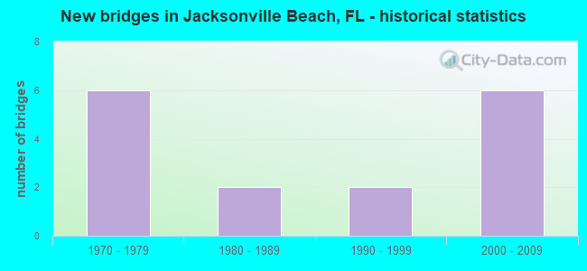
- New bridges - historical statistics
- 61970-1979
- 21980-1989
- 21990-1999
- 62000-2009


- Bridge Condition - Superstructure
- 16.7%Very good
- 66.7%Good
- 16.7%Satisfactory

- Bridge Condition - Substructure
- 75.0%Good
- 25.0%Satisfactory

- Bridge Condition - Channel
- 22.2%Very good
- 55.6%Good
- 11.1%Satisfactory
- 11.1%Fair
Find on map >> Show street view
Structure Number: 100805, Location: 0.8MI WEST OF US-41 (Lat: 27.954283, Lng: -82.415539), Route carried "on" structure: State highway 618, Year Built: 2005, Status: Open, Structure Length: 5.33m (17.49ft), Average Daily Traffic: 19,500 (year 2021), Truck Traffic: 8%, Average Future Daily Traffic: 33,832 (year 2041), Design Load: HS 20+Mod, Features Intersected: MCKAY BAY GREENWAY
Minimum Vertical Clearance: 30+ m (98+ ft), Kilometerpoint: 13.182, Lanes on structure: 2, Lanes under structure: 2, Base Highway Network: Yes, Toll: On toll road, Owner: State Toll Authority, Maintenance Responsibility: State Highway Agency, Approaching Roadway Width: 13.4m (44.0ft), Material/Design: Prestressed concrete, Design/Construction: Stringer/Multi-beam, Number Of Spans In Main Unit: 3, Length of Maximum Span: 27.1m (88.9ft), Curb-To-Curb Width: 13.4m (44.0ft), Out-to-Out Width: 14.3m (46.9ft)
Condition: Deck: Good, Superstructure: Good, Substructure: Good, Operating Rating: 66.8 metric tons, Method Used To Determine Operating Rating: Load Factor (LF), Inventory Rating: 40.0 metric tons, Method Used To Determine Inventory Rating: Load Factor (LF), Structural Evaluation: Better than present minimum criteria, Deck Geometry: Superior to present desirable criteria, Underclear: Superior to present desirable criteria, Approach Roadway Alignment: Equal to present desirable criteria, Designated Inspection Frequency: Every 24 months, Inspection Date: August 2021, Deck Structure Type: Concrete Cast-file-Place
Find on map >> Show street view
Structure Number: 720442, Location: 0.3 MI.E.OF SAN PABLO RD. (Lat: 30.257400, Lng: -81.428400), Route carried "on" structure: State highway 202, Year Built: 1979, Status: Open, Structure Length: 140.03m (459.42ft), Average Daily Traffic: 28,250 (year 2020), Truck Traffic: 8%, Average Future Daily Traffic: 49,014 (year 2042), Design Load: HS 20, Features Intersected: INTRACOASTAL WATERWAY
Minimum Vertical Clearance: 30+ m (98+ ft), Kilometerpoint: 16.670, Lanes on structure: 2, Base Highway Network: Yes, Owner: State Highway Agency, Approaching Roadway Width: 11.9m (39.0ft), Navigation Control: Yes ( Vertical Clearance: 19.8m (65.0ft), Horizontal Clearance: 27.7m (90.9ft)), Material/Design: Prestressed concrete, Design/Construction: Stringer/Multi-beam, Number Of Spans In Main Unit: 66, Length of Maximum Span: 31.1m (102.0ft), Curb-To-Curb Width: 12.1m (39.7ft), Out-to-Out Width: 13.0m (42.7ft)
Condition: Deck: Good, Superstructure: Satisfactory, Substructure: Satisfactory, Channel: Satisfactory, Operating Rating: 39.6 metric tons, Method Used To Determine Operating Rating: Load and Resistance Factor (LRFR), Inventory Rating: 29.0 metric tons, Method Used To Determine Inventory Rating: Load and Resistance Factor (LRFR), Structural Evaluation: Equal to present minimum criteria, Deck Geometry: Equal to present minimum criteria, Waterway Adequacy: Equal to present desirable criteria, Approach Roadway Alignment: Equal to present minimum criteria, Length Of Structure Improvement: 140.03m (459.42ft), Designated Inspection Frequency: Every 24 months, Underwater Inspection Frequency: Every 23 months, Inspection Date: September 2021, Underwater Inspection Date: September 2021, Bridge Improvement Cost: $500,000, Total Project Cost: $500,000, Deck Structure Type: Concrete Cast-file-Place
Find on map >> Show street view
Structure Number: 720443, Location: 1.7 MI. W. OF SR-A1A (Lat: 30.258725, Lng: -81.413317), Route carried "on" structure: State highway 202, Year Built: 1978, Status: Open, Structure Length: 18.29m (60.01ft), Average Daily Traffic: 28,250 (year 2020), Truck Traffic: 8%, Average Future Daily Traffic: 49,014 (year 2042), Design Load: HS 20, Features Intersected: CUT CREEK BRANCH
Minimum Vertical Clearance: 30+ m (98+ ft), Kilometerpoint: 18.337, Lanes on structure: 2, Base Highway Network: Yes, Owner: State Highway Agency, Approaching Roadway Width: 11.9m (39.0ft), Navigation Control: Yes ( Vertical Clearance: 1.8m (5.9ft), Horizontal Clearance: 14.3m (46.9ft)), Material/Design: Prestressed concrete, Design/Construction: Stringer/Multi-beam, Number Of Spans In Main Unit: 12, Length of Maximum Span: 15.2m (49.9ft), Curb-To-Curb Width: 12.2m (40.0ft), Out-to-Out Width: 13.0m (42.7ft)
Condition: Deck: Good, Superstructure: Good, Substructure: Satisfactory, Channel: Good, Operating Rating: 43.5 metric tons, Method Used To Determine Operating Rating: Load and Resistance Factor (LRFR), Inventory Rating: 25.1 metric tons, Method Used To Determine Inventory Rating: Load and Resistance Factor (LRFR), Structural Evaluation: Equal to present minimum criteria, Deck Geometry: Better than present minimum criteria, Waterway Adequacy: Equal to present desirable criteria, Approach Roadway Alignment: Equal to present desirable criteria, Designated Inspection Frequency: Every 24 months, Inspection Date: December 2020, Deck Structure Type: Concrete Cast-file-Place
Find on map >> Show street view
Structure Number: 720444, Location: 1.3 MI. W. OF SR-A1A (Lat: 30.259261, Lng: -81.407978), Route carried "on" structure: State highway 202, Year Built: 1978, Status: Open, Structure Length: 5.94m (19.49ft), Average Daily Traffic: 28,250 (year 2020), Truck Traffic: 8%, Average Future Daily Traffic: 49,014 (year 2042), Design Load: HS 20, Features Intersected: CUT CREEK TRIBUTARY
Minimum Vertical Clearance: 30+ m (98+ ft), Kilometerpoint: 18.940, Lanes on structure: 2, Base Highway Network: Yes, Owner: State Highway Agency, Approaching Roadway Width: 11.9m (39.0ft), Navigation Control: Yes ( Vertical Clearance: 1.2m (3.9ft), Horizontal Clearance: 14.0m (45.9ft)), Material/Design: Prestressed concrete, Design/Construction: Stringer/Multi-beam, Number Of Spans In Main Unit: 4, Length of Maximum Span: 14.9m (48.9ft), Curb-To-Curb Width: 12.2m (40.0ft), Out-to-Out Width: 13.1m (43.0ft)
Condition: Deck: Good, Superstructure: Good, Substructure: Good, Channel: Good, Operating Rating: 52.6 metric tons, Method Used To Determine Operating Rating: Load Factor (LF), Inventory Rating: 32.6 metric tons, Method Used To Determine Inventory Rating: Load Factor (LF), Structural Evaluation: Better than present minimum criteria, Deck Geometry: Better than present minimum criteria, Waterway Adequacy: Equal to present desirable criteria, Approach Roadway Alignment: Equal to present desirable criteria, Designated Inspection Frequency: Every 24 months, Inspection Date: December 2020, Deck Structure Type: Concrete Cast-file-Place
Find on map >> Show street view
Structure Number: 720445, Location: 1.3 MI. W. OF SR-A1A (Lat: 30.259067, Lng: -81.407964), Route carried "on" structure: State highway 202, Year Built: 1978, Status: Open, Structure Length: 5.94m (19.49ft), Average Daily Traffic: 28,250 (year 2020), Truck Traffic: 8%, Average Future Daily Traffic: 49,014 (year 2042), Design Load: HS 20, Features Intersected: CUT CREEK TRIBUTARY
Minimum Vertical Clearance: 30+ m (98+ ft), Kilometerpoint: 18.940, Lanes on structure: 2, Base Highway Network: Yes, Owner: State Highway Agency, Approaching Roadway Width: 12.2m (40.0ft), Navigation Control: Yes ( Vertical Clearance: 1.2m (3.9ft), Horizontal Clearance: 14.0m (45.9ft)), Material/Design: Prestressed concrete, Design/Construction: Stringer/Multi-beam, Number Of Spans In Main Unit: 4, Length of Maximum Span: 14.9m (48.9ft), Curb-To-Curb Width: 12.2m (40.0ft), Out-to-Out Width: 13.1m (43.0ft)
Condition: Deck: Good, Superstructure: Good, Substructure: Satisfactory, Channel: Good, Operating Rating: 55.3 metric tons, Method Used To Determine Operating Rating: Load Factor (LF), Inventory Rating: 34.4 metric tons, Method Used To Determine Inventory Rating: Load Factor (LF), Structural Evaluation: Equal to present minimum criteria, Deck Geometry: Better than present minimum criteria, Waterway Adequacy: Equal to present desirable criteria, Approach Roadway Alignment: Equal to present desirable criteria, Designated Inspection Frequency: Every 24 months, Inspection Date: December 2020, Deck Structure Type: Concrete Cast-file-Place
Find on map >> Show street view
Structure Number: 720455, Location: 0.4 MI. W. OF SR-A1A (Lat: 30.256111, Lng: -81.394444), Route carried "on" structure: State highway 202, Year Built: 1979, Status: Open, Structure Length: 5.03m (16.50ft), Average Daily Traffic: 36,500 (year 2020), Truck Traffic: 8%, Average Future Daily Traffic: 63,328 (year 2042), Design Load: HS 20, Features Intersected: SOUTH BEACH PARKWAY
Minimum Vertical Clearance: 30+ m (98+ ft), Kilometerpoint: 20.336, Lanes on structure: 4, Lanes under structure: 4, Base Highway Network: Yes, Owner: State Highway Agency, Approaching Roadway Width: 23.2m (76.1ft), Skew: 10 degrees, Material/Design: Prestressed concrete, Design/Construction: Stringer/Multi-beam, Number Of Spans In Main Unit: 3, Length of Maximum Span: 27.1m (88.9ft), Curb-To-Curb Width: 24.4m (80.1ft), Out-to-Out Width: 25.9m (85.0ft)
Condition: Deck: Good, Superstructure: Very good, Substructure: Good, Operating Rating: 48.0 metric tons, Method Used To Determine Operating Rating: Load and Resistance Factor (LRFR), Inventory Rating: 17.6 metric tons, Method Used To Determine Inventory Rating: Load and Resistance Factor (LRFR), Structural Evaluation: Meets minimum limits, Deck Geometry: Superior to present desirable criteria, Underclear: Equal to present minimum criteria, Approach Roadway Alignment: Equal to present desirable criteria, Designated Inspection Frequency: Every 24 months, Inspection Date: January 2021, Deck Structure Type: Concrete Cast-file-Place
Find on map >> Show street view
Structure Number: 720509, Location: 0.3 MI.E.OF SAN PABLO RD. (Lat: 30.257222, Lng: -81.427778), Route carried "on" structure: State highway 202, Year Built: 1988, Status: Open, Structure Length: 140.03m (459.42ft), Average Daily Traffic: 28,250 (year 2020), Truck Traffic: 8%, Average Future Daily Traffic: 49,014 (year 2042), Design Load: HS 20+Mod, Features Intersected: INTRACOASTAL WATERWAY
Minimum Vertical Clearance: 30+ m (98+ ft), Kilometerpoint: 16.670, Lanes on structure: 2, Base Highway Network: Yes, Owner: State Highway Agency, Approaching Roadway Width: 18.7m (61.4ft), Navigation Control: Yes ( Vertical Clearance: 19.8m (65.0ft), Horizontal Clearance: 27.7m (90.9ft)), Material/Design: Prestressed concrete, Design/Construction: Stringer/Multi-beam, Number Of Spans In Main Unit: 66, Length of Maximum Span: 42.7m (140.1ft), Curb-To-Curb Width: 12.1m (39.7ft), Out-to-Out Width: 13.0m (42.7ft)
Condition: Deck: Good, Superstructure: Good, Substructure: Good, Channel: Fair, Operating Rating: 46.1 metric tons, Method Used To Determine Operating Rating: Load and Resistance Factor (LRFR), Inventory Rating: 34.7 metric tons, Method Used To Determine Inventory Rating: Load and Resistance Factor (LRFR), Structural Evaluation: Better than present minimum criteria, Deck Geometry: Equal to present minimum criteria, Waterway Adequacy: Superior to present desirable criteria, Approach Roadway Alignment: Equal to present minimum criteria, Length Of Structure Improvement: 140.03m (459.42ft), Designated Inspection Frequency: Every 24 months, Underwater Inspection Frequency: Every 23 months, Inspection Date: September 2021, Underwater Inspection Date: September 2021, Bridge Improvement Cost: $500,000, Total Project Cost: $500,000, Deck Structure Type: Concrete Cast-file-Place
Find on map >> Show street view
Structure Number: 720514, Location: 1.7 MI. W. OF SR-A1A (Lat: 30.258489, Lng: -81.413822), Route carried "on" structure: State highway 202, Year Built: 1988, Status: Open, Structure Length: 18.29m (60.01ft), Average Daily Traffic: 28,250 (year 2020), Truck Traffic: 8%, Average Future Daily Traffic: 49,014 (year 2042), Design Load: HS 20+Mod, Features Intersected: CUT CREEK BRANCH
Minimum Vertical Clearance: 30+ m (98+ ft), Kilometerpoint: 18.337, Lanes on structure: 2, Base Highway Network: Yes, Owner: State Highway Agency, Approaching Roadway Width: 12.2m (40.0ft), Navigation Control: Yes ( Vertical Clearance: 1.8m (5.9ft), Horizontal Clearance: 14.3m (46.9ft)), Material/Design: Prestressed concrete, Design/Construction: Stringer/Multi-beam, Number Of Spans In Main Unit: 12, Length of Maximum Span: 15.2m (49.9ft), Curb-To-Curb Width: 12.2m (40.0ft), Out-to-Out Width: 13.0m (42.7ft)
Condition: Deck: Good, Superstructure: Good, Substructure: Good, Channel: Good, Operating Rating: 50.3 metric tons, Method Used To Determine Operating Rating: Load Factor (LF), Inventory Rating: 36.3 metric tons, Method Used To Determine Inventory Rating: Load Factor (LF), Structural Evaluation: Better than present minimum criteria, Deck Geometry: Better than present minimum criteria, Waterway Adequacy: Equal to present desirable criteria, Approach Roadway Alignment: Equal to present desirable criteria, Designated Inspection Frequency: Every 24 months, Inspection Date: December 2020, Deck Structure Type: Concrete Cast-file-Place
Find on map >> Show street view
Structure Number: 72062, Location: SR-202 / SR-A1A (Lat: 30.255914, Lng: -81.388353), Route carried "on" structure: State highway 202, Year Built: 1997, Status: Open, Structure Length: 5.15m (16.90ft), Average Daily Traffic: 36,500 (year 2020), Truck Traffic: 7%, Average Future Daily Traffic: 63,328 (year 2042), Design Load: HS 20+Mod, Features Intersected: SR-A1A
Minimum Vertical Clearance: 30+ m (98+ ft), Kilometerpoint: 20.905, Lanes on structure: 2, Lanes under structure: 5, Base Highway Network: Yes, Owner: State Highway Agency, Approaching Roadway Width: 20.4m (66.9ft), Skew: 10 degrees, Material/Design: Prestressed concrete, Design/Construction: Stringer/Multi-beam, Number Of Spans In Main Unit: 2, Length of Maximum Span: 29.2m (95.8ft), Curb-To-Curb Width: 20.4m (66.9ft), Out-to-Out Width: 21.9m (71.9ft)
Condition: Deck: Good, Superstructure: Good, Substructure: Good, Operating Rating: 49.4 metric tons, Method Used To Determine Operating Rating: Load and Resistance Factor (LRFR), Inventory Rating: 38.2 metric tons, Method Used To Determine Inventory Rating: Load and Resistance Factor (LRFR), Structural Evaluation: Better than present minimum criteria, Deck Geometry: Superior to present desirable criteria, Underclear: Superior to present desirable criteria, Approach Roadway Alignment: Equal to present minimum criteria, Designated Inspection Frequency: Every 24 months, Inspection Date: July 2021, Deck Structure Type: Concrete Cast-file-Place
Find on map >> Show street view
Structure Number: 720729, Location: US-90 / INTRACOASTAL WW (Lat: 30.288333, Lng: -81.421389), Route carried "on" structure: US 90, Year Built: 2008, Status: Open, Structure Length: 70.04m (229.79ft), Average Daily Traffic: 17,907 (year 2020), Truck Traffic: 4%, Average Future Daily Traffic: 31,069 (year 2042), Design Load: HL 93, Features Intersected: INTRACOASTAL WATERWAY
Minimum Vertical Clearance: 30+ m (98+ ft), Kilometerpoint: 20.648, Lanes on structure: 3, Lanes under structure: 4, Base Highway Network: Yes, Owner: State Highway Agency, Approaching Roadway Width: 13.0m (42.7ft), Navigation Control: Yes ( Vertical Clearance: 0.3m (1.0ft), Horizontal Clearance: 0.3m (1.0ft)), Material/Design: Prestressed concrete, Design/Construction: Stringer/Multi-beam, Number Of Spans In Main Unit: 17, Length of Maximum Span: 45.1m (148.0ft), Curb or Sidewalk Widths: Left: 2.0m (6.6ft), Right: 0.0m, Curb-To-Curb Width: 19.0m (62.3ft), Out-to-Out Width: 19.9m (65.3ft)
Condition: Deck: Good, Superstructure: Satisfactory, Substructure: Good, Channel: Good, Operating Rating: 65.8 metric tons, Method Used To Determine Operating Rating: Load Factor (LF), Inventory Rating: 39.5 metric tons, Method Used To Determine Inventory Rating: Load Factor (LF), Structural Evaluation: Equal to present minimum criteria, Deck Geometry: Superior to present desirable criteria, Underclear: Superior to present desirable criteria, Waterway Adequacy: Equal to present desirable criteria, Approach Roadway Alignment: Equal to present desirable criteria, Designated Inspection Frequency: Every 24 months, Underwater Inspection Frequency: Every 23 months, Inspection Date: December 2021, Underwater Inspection Date: December 2021, Deck Structure Type: Concrete Cast-file-Place
Find on map >> Show street view
Structure Number: 72441, Location: 0.1M N OF JACKSONVILLE DR (Lat: 30.260744, Lng: -81.391389), Route carried "on" structure: City street , Year Built: 2006, Status: Open, Structure Length: 1.83m (6.00ft), Average Daily Traffic: 100 (year 2020), Average Future Daily Traffic: 174 (year 2042), Design Load: HS 20, Features Intersected: PARADISE CANAL, Facility Carried by Structure: PARADISE WAY
Minimum Vertical Clearance: 30+ m (98+ ft), Kilometerpoint: 0.000, Lanes on structure: 2, Owner: City or Municipal Highway Agency, Approaching Roadway Width: 7.3m (24.0ft), Material/Design: Wood or Timber, Design/Construction: Stringer/Multi-beam, Number Of Spans In Main Unit: 1, Length of Maximum Span: 18.3m (60.0ft), Curb-To-Curb Width: 7.3m (24.0ft), Out-to-Out Width: 7.7m (25.3ft)
Condition: Deck: Good, Superstructure: Very good, Substructure: Good, Channel: Very good, Operating Rating: 60.5 metric tons, Method Used To Determine Operating Rating: Load Factor (LF), Inventory Rating: 42.3 metric tons, Method Used To Determine Inventory Rating: Load Factor (LF), Structural Evaluation: Better than present minimum criteria, Deck Geometry: Equal to present minimum criteria, Waterway Adequacy: Equal to present desirable criteria, Approach Roadway Alignment: Equal to present minimum criteria, Designated Inspection Frequency: Every 24 months, Inspection Date: August 2020, Deck Structure Type: Wood or Timber, Wearing Surface/Protective System: Wearing Surface: Bituminous
Find on map >> Show street view
Structure Number: 724411, Location: 0.05 MI S OF PARADISE WAY (Lat: 30.260278, Lng: -81.392222), Route carried "on" structure: City street , Year Built: 2006, Status: Open, Structure Length: 1.83m (6.00ft), Average Daily Traffic: 100 (year 2020), Average Future Daily Traffic: 174 (year 2042), Design Load: HS 20, Features Intersected: PARADISE CANAL, Facility Carried by Structure: MARATHON KEY
Minimum Vertical Clearance: 30+ m (98+ ft), Kilometerpoint: 0.000, Lanes on structure: 2, Owner: City or Municipal Highway Agency, Approaching Roadway Width: 7.3m (24.0ft), Skew: 4 degrees, Material/Design: Wood or Timber, Design/Construction: Stringer/Multi-beam, Number Of Spans In Main Unit: 1, Length of Maximum Span: 18.3m (60.0ft), Curb-To-Curb Width: 7.3m (24.0ft), Out-to-Out Width: 7.7m (25.3ft)
Condition: Deck: Good, Superstructure: Good, Substructure: Good, Channel: Very good, Operating Rating: 60.5 metric tons, Method Used To Determine Operating Rating: Load Factor (LF), Inventory Rating: 42.3 metric tons, Method Used To Determine Inventory Rating: Load Factor (LF), Structural Evaluation: Better than present minimum criteria, Deck Geometry: Equal to present minimum criteria, Waterway Adequacy: Equal to present desirable criteria, Approach Roadway Alignment: Equal to present minimum criteria, Designated Inspection Frequency: Every 24 months, Inspection Date: August 2020, Deck Structure Type: Wood or Timber, Wearing Surface/Protective System: Wearing Surface: Bituminous
Find on map >> Show street view
Structure Number: 720455, Location: 0.4 MI. W. OF SR-A1A (Lat: 30.256111, Lng: -81.394444), Route carried "under" structure: City street , Year Built: 1979, Structure Length: 0. m, Average Daily Traffic: 10,700 (year 2020), Truck Traffic: 3%, Features Intersected: SOUTH BEACH PARKWAY, Facility Carried by Structure: SR-202 (JTB)
Minimum Vertical Clearance: 5.15m (16.90ft), Kilometerpoint: 0.026, Lanes on structure: 4, Lanes under structure: 4, Material/Design: Prestressed concrete, Design/Construction: Stringer/Multi-beam, Length of Maximum Span: 27.1m (88.9ft)
Find on map >> Show street view
Structure Number: 72062, Location: SR-202 / SR-A1A (Lat: 30.255914, Lng: -81.388353), Route carried "under" structure: State highway A1A, Year Built: 1997, Structure Length: 0. m, Average Daily Traffic: 34,000 (year 2020), Truck Traffic: 3%, Features Intersected: SR-A1A, Facility Carried by Structure: SR-202 (JTB)
Minimum Vertical Clearance: 5.91m (19.39ft), Kilometerpoint: 0.343, Lanes on structure: 2, Lanes under structure: 4, Material/Design: Prestressed concrete, Design/Construction: Stringer/Multi-beam, Length of Maximum Span: 29.2m (95.8ft)
Find on map >> Show street view
Structure Number: 720729, Location: US-90 / INTRACOASTAL WW (Lat: 30.288333, Lng: -81.421389), Route carried "under" structure: City street , Year Built: 2008, Structure Length: 0. m, Average Daily Traffic: 21 (year 2020), Truck Traffic: 5%, Features Intersected: INTRACOASTAL WATERWAY, Facility Carried by Structure: US-90 WB (SR-212)
Minimum Vertical Clearance: 16.74m (54.92ft), Kilometerpoint: 0.000, Lanes on structure: 3, Lanes under structure: 2, Material/Design: Prestressed concrete, Design/Construction: Stringer/Multi-beam, Length of Maximum Span: 45.1m (148.0ft)
Find on map >> Show street view
Structure Number: 720729, Location: US-90 / INTRACOASTAL WW (Lat: 30.288333, Lng: -81.421389), Route carried "under" structure: City street , Year Built: 2008, Structure Length: 0. m, Average Daily Traffic: 21 (year 2020), Truck Traffic: 5%, Features Intersected: INTRACOASTAL WATERWAY, Facility Carried by Structure: US-90 WB (SR-212)
Minimum Vertical Clearance: 6.40m (21.00ft), Kilometerpoint: 0.000, Lanes on structure: 3, Lanes under structure: 2, Material/Design: Prestressed concrete, Design/Construction: Stringer/Multi-beam, Length of Maximum Span: 45.1m (148.0ft)