Bridge Statistics for Irondequoit, New York (NY)
Condition, Traffic, Stress, Structural Evaluation, Project Costs
- National Bridge Inventory (NBI) Statistics
- 49Number of bridges
- 597ft / 182mTotal length
- $265,400,000Total costs
- 1,253,035Total average daily traffic
- 22,467Total average daily truck traffic
- National Bridge Inventory (NBI) Registered Bridges for Irondequoit
- No street view available for this location
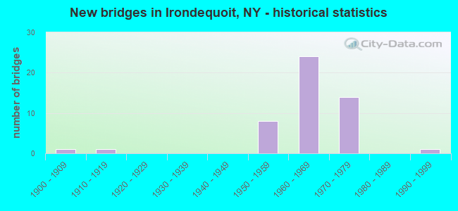
- New bridges - historical statistics
- 11900-1909
- 11910-1919
- 81950-1959
- 241960-1969
- 141970-1979
- 11990-1999
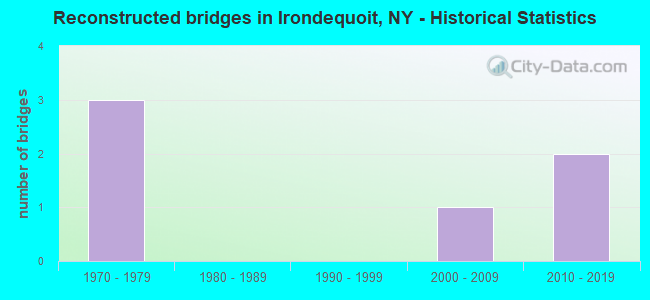
- Reconstructed bridges - Historical Statistics
- 31970-1979
- 01980-1989
- 01990-1999
- 12000-2009
- 22010-2019
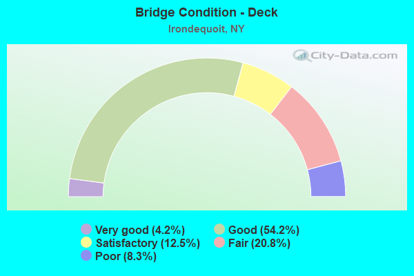
- Bridge Condition - Deck
- 4.2%Very good
- 54.2%Good
- 12.5%Satisfactory
- 20.8%Fair
- 8.3%Poor
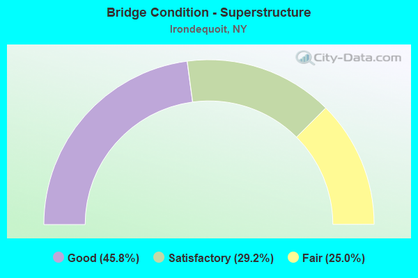
- Bridge Condition - Superstructure
- 45.8%Good
- 29.2%Satisfactory
- 25.0%Fair
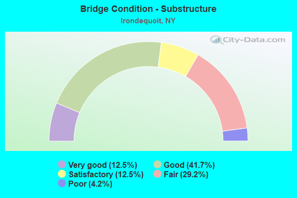
- Bridge Condition - Substructure
- 12.5%Very good
- 41.7%Good
- 12.5%Satisfactory
- 29.2%Fair
- 4.2%Poor
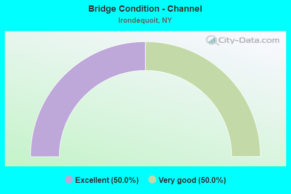
- Bridge Condition - Channel
- 50.0%Excellent
- 50.0%Very good
Find on map >> Show street view
Structure Number: 1014841, Location: Jct SH 590 & Co Rd 241 (Lat: 43.204647, Lng: -77.548756), Route carried "on" structure: State highway 590, Year Built: 1957, Year Reconstructed: 1984, Status: Open, Structure Length: 4.82m (15.81ft), Average Daily Traffic: 6,938 (year 2019), Truck Traffic: 4%, Average Future Daily Traffic: 7,236 (year 2040), Design Load: HS 20, Features Intersected: RTE 940C
Minimum Vertical Clearance: 30+ m (98+ ft), Kilometerpoint: 7.321, Lanes on structure: 1, Lanes under structure: 3, Base Highway Network: Yes, Owner: State Highway Agency, Approaching Roadway Width: 11.9m (39.0ft), Material/Design: Steel, Design/Construction: Stringer/Multi-beam, Number Of Spans In Main Unit: 3, Length of Maximum Span: 24.1m (79.1ft), Curb-To-Curb Width: 9.8m (32.2ft), Out-to-Out Width: 10.8m (35.4ft)
Condition: Deck: Poor, Superstructure: Satisfactory, Substructure: Very good, Operating Rating: 71.7 metric tons, Method Used To Determine Operating Rating: Load Factor (LF), Inventory Rating: 42.6 metric tons, Method Used To Determine Inventory Rating: Load Factor (LF), Structural Evaluation: Equal to present minimum criteria, Deck Geometry: Meets minimum limits, Underclear: Meets minimum limits, Approach Roadway Alignment: Equal to present desirable criteria, Length Of Structure Improvement: 4.81m (15.78ft), Designated Inspection Frequency: Every 24 months, Inspection Date: November 2021, Bridge Improvement Cost: $1,250,000, Roadway Improvement Cost: $732,000, Total Project Cost: $1,981,000 ( Estimate for 2021), Deck Structure Type: Concrete Cast-file-Place, Wearing Surface/Protective System: Wearing Surface: Bituminous, Membrane: Preformed Fabric, Deck Protection: Epoxy Coated Reinforcing
Find on map >> Show street view
Structure Number: 1014842, Location: JCT S H 590 & CO ROAD 241 (Lat: 43.204661, Lng: -77.548558), Route carried "on" structure: State highway 590, Year Built: 1957, Year Reconstructed: 1984, Status: Open, Structure Length: 4.75m (15.58ft), Average Daily Traffic: 6,938 (year 2019), Truck Traffic: 4%, Average Future Daily Traffic: 7,236 (year 2040), Design Load: HS 20, Features Intersected: RTE 940C
Minimum Vertical Clearance: 30+ m (98+ ft), Kilometerpoint: 7.321, Lanes on structure: 2, Lanes under structure: 3, Base Highway Network: Yes, Owner: State Highway Agency, Approaching Roadway Width: 11.9m (39.0ft), Material/Design: Steel, Design/Construction: Stringer/Multi-beam, Number Of Spans In Main Unit: 3, Length of Maximum Span: 24.0m (78.7ft), Curb-To-Curb Width: 9.8m (32.2ft), Out-to-Out Width: 10.8m (35.4ft)
Condition: Deck: Poor, Superstructure: Fair, Substructure: Good, Operating Rating: 71.7 metric tons, Method Used To Determine Operating Rating: Load Factor (LF), Inventory Rating: 42.6 metric tons, Method Used To Determine Inventory Rating: Load Factor (LF), Structural Evaluation: Somewhat better than minimum adequacy, Deck Geometry: High priority of replacement, Underclear: Meets minimum limits, Approach Roadway Alignment: Equal to present desirable criteria, Length Of Structure Improvement: 4.75m (15.58ft), Designated Inspection Frequency: Every 24 months, Inspection Date: November 2021, Bridge Improvement Cost: $1,236,000, Roadway Improvement Cost: $724,000, Total Project Cost: $1,960,000 ( Estimate for 2021), Deck Structure Type: Concrete Cast-file-Place, Wearing Surface/Protective System: Wearing Surface: Bituminous, Deck Protection: Epoxy Coated Reinforcing
Find on map >> Show street view
Structure Number: 101485, Location: 0.3 M E of SeaBreeze Dr. (Lat: 43.234853, Lng: -77.534419), Route carried "on" structure: County highway 941L, Year Built: 1998, Status: Open, Structure Length: 5.88m (19.29ft), Average Daily Traffic: 2,249 (year 2020), Truck Traffic: 2%, Average Future Daily Traffic: 2,782 (year 2040), Design Load: HS 25 or greater, Features Intersected: IROND. BAY OUTLET
Minimum Vertical Clearance: 30+ m (98+ ft), Kilometerpoint: 6.211, Lanes on structure: 2, Owner: County Highway Agency, Approaching Roadway Width: 7.3m (24.0ft), Navigation Control: Yes ( Vertical Clearance: 1.2m (3.9ft), Horizontal Clearance: 30.4m (99.7ft)), Material/Design: Steel, Design/Construction: Movable - Swing, Number Of Spans In Main Unit: 2, Length of Maximum Span: 40.5m (132.9ft), Curb or Sidewalk Widths: Left: 1.5m (4.9ft), Right: 1.5m (4.9ft), Curb-To-Curb Width: 7.3m (24.0ft), Out-to-Out Width: 8.8m (28.9ft)
Condition: Deck: Very good, Superstructure: Satisfactory, Substructure: Very good, Channel: Very good, Operating Rating: 84.1 metric tons, Method Used To Determine Operating Rating: Field evaluation and documented engineering judgment, Inventory Rating: 40.8 metric tons, Method Used To Determine Inventory Rating: Field evaluation and documented engineering judgment, Structural Evaluation: Equal to present minimum criteria, Deck Geometry: High priority of replacement, Waterway Adequacy: Equal to present minimum criteria, Approach Roadway Alignment: Equal to present desirable criteria, Length Of Structure Improvement: 5.88m (19.29ft), Designated Inspection Frequency: Every 24 months, Critical Feature Inspection Frequency: Every 12 months, Inspection Date: November 2021, Critical Feature Inspection Date: November 2021, Bridge Improvement Cost: $4,950,000, Roadway Improvement Cost: $2,898,000, Total Project Cost: $7,848,000 ( Estimate for 2021), Deck Structure Type: Concrete Cast-file-Place, Wearing Surface/Protective System: Wearing Surface: Monolithic Concrete, Deck Protection: Galvanized Reinforcing
Find on map >> Show street view
Structure Number: 102607, Location: 1.1MI N JCT ROL+RTE286 (Lat: 43.172778, Lng: -77.540544), Route carried "on" structure: County highway , Year Built: 1960, Status: Open, Structure Length: 7.56m (24.80ft), Average Daily Traffic: 5,859 (year 2017), Truck Traffic: 2%, Average Future Daily Traffic: 7,117 (year 2040), Design Load: HS 20+Mod, Features Intersected: 590 590 43013004 North B, Facility Carried by Structure: WINTON RD N
Minimum Vertical Clearance: 30+ m (98+ ft), Kilometerpoint: 0.644, Lanes on structure: 2, Lanes under structure: 7, Owner: State Highway Agency, Approaching Roadway Width: 12.2m (40.0ft), Skew: 3 degrees, Material/Design: Steel, Design/Construction: Stringer/Multi-beam, Number Of Spans In Main Unit: 4, Length of Maximum Span: 24.6m (80.7ft), Curb or Sidewalk Widths: Left: 1.5m (4.9ft), Right: 1.5m (4.9ft), Curb-To-Curb Width: 14.6m (47.9ft), Out-to-Out Width: 18.3m (60.0ft)
Condition: Deck: Fair, Superstructure: Fair, Substructure: Good, Operating Rating: 66.7 metric tons, Method Used To Determine Operating Rating: Load and Resistance Factor Rating (LRFR) rating reported by rating factor(RF) method using HL-93 loadings, Inventory Rating: 51.2 metric tons, Method Used To Determine Inventory Rating: Load and Resistance Factor Rating (LRFR) rating reported by rating factor(RF) method using HL-93 loadings, Structural Evaluation: Somewhat better than minimum adequacy, Deck Geometry: Superior to present desirable criteria, Underclear: High priority of corrective action, Approach Roadway Alignment: Equal to present desirable criteria, Length Of Structure Improvement: 7.55m (24.77ft), Designated Inspection Frequency: Every 24 months, Inspection Date: November 2020, Bridge Improvement Cost: $3,350,000, Roadway Improvement Cost: $1,962,000, Total Project Cost: $5,311,000 ( Estimate for 2021), Deck Structure Type: Concrete Cast-file-Place, Wearing Surface/Protective System: Wearing Surface: Latex Concrete
Find on map >> Show street view
Structure Number: 1026089, Location: JCT ROL+RTE404 (Lat: 43.176831, Lng: -77.542739), Route carried "on" structure: State highway 590, Year Built: 1957, Year Reconstructed: 1984, Status: Open, Structure Length: 5.00m (16.40ft), Average Daily Traffic: 86,307 (year 2020), Truck Traffic: 4%, Average Future Daily Traffic: 90,026 (year 2040), Design Load: HS 20, Features Intersected: RTE 404
Minimum Vertical Clearance: 30+ m (98+ ft), Kilometerpoint: 4.167, Lanes on structure: 7, Lanes under structure: 6, Base Highway Network: Yes, Owner: State Highway Agency, Approaching Roadway Width: 33.2m (108.9ft), Skew: 20 degrees, Material/Design: Steel, Design/Construction: Stringer/Multi-beam, Number Of Spans In Main Unit: 3, Length of Maximum Span: 27.7m (90.9ft), Curb-To-Curb Width: 36.0m (118.1ft), Out-to-Out Width: 37.5m (123.0ft)
Condition: Deck: Fair, Superstructure: Fair, Substructure: Fair, Operating Rating: 78.0 metric tons, Method Used To Determine Operating Rating: Load Factor (LF), Inventory Rating: 46.3 metric tons, Method Used To Determine Inventory Rating: Load Factor (LF), Structural Evaluation: Somewhat better than minimum adequacy, Deck Geometry: Superior to present desirable criteria, Underclear: Meets minimum limits, Approach Roadway Alignment: Equal to present desirable criteria, Length Of Structure Improvement: 4.99m (16.37ft), Designated Inspection Frequency: Every 24 months, Inspection Date: December 2021, Bridge Improvement Cost: $4,499,000, Roadway Improvement Cost: $2,635,000, Total Project Cost: $7,134,000 ( Estimate for 2021), Deck Structure Type: Concrete Cast-file-Place, Wearing Surface/Protective System: Wearing Surface: Integral Concrete, Deck Protection: Epoxy Coated Reinforcing
Find on map >> Show street view
Structure Number: 103647, Location: JCT RT 104 EB & ROCH O L (Lat: 43.198444, Lng: -77.547689), Route carried "on" structure: State highway 104, Year Built: 1968, Status: Open, Structure Length: 10.36m (33.99ft), Average Daily Traffic: 64,421 (year 2019), Truck Traffic: 4%, Average Future Daily Traffic: 67,197 (year 2040), Design Load: HS 20, Features Intersected: 590I NB TO 104 W, 590
Minimum Vertical Clearance: 30+ m (98+ ft), Kilometerpoint: 37.940, Lanes on structure: 2, Lanes under structure: 8, Base Highway Network: Yes, Owner: State Highway Agency, Approaching Roadway Width: 7.3m (24.0ft), Skew: 4 degrees, Material/Design: Steel, Design/Construction: Stringer/Multi-beam, Number Of Spans In Main Unit: 4, Length of Maximum Span: 27.4m (89.9ft), Curb-To-Curb Width: 8.5m (27.9ft), Out-to-Out Width: 10.1m (33.1ft)
Condition: Deck: Good, Superstructure: Good, Substructure: Good, Operating Rating: 92.5 metric tons, Method Used To Determine Operating Rating: Load Factor (LF), Inventory Rating: 55.3 metric tons, Method Used To Determine Inventory Rating: Load Factor (LF), Structural Evaluation: Better than present minimum criteria, Deck Geometry: High priority of corrective action, Underclear: High priority of corrective action, Approach Roadway Alignment: Equal to present minimum criteria, Length Of Structure Improvement: 10.36m (33.99ft), Designated Inspection Frequency: Every 24 months, Inspection Date: November 2021, Bridge Improvement Cost: $2,508,000, Roadway Improvement Cost: $1,469,000, Total Project Cost: $3,977,000 ( Estimate for 2021), Deck Structure Type: Concrete Cast-file-Place, Wearing Surface/Protective System: Wearing Surface: Latex Concrete
Find on map >> Show street view
Structure Number: 1051289, Location: JCT RTS 47NB TO 104WB (Lat: 43.198144, Lng: -77.547567), Route carried "on" structure: State highway 590, Year Built: 1968, Status: Open, Structure Length: 2.53m (8.30ft), Average Daily Traffic: 49,106 (year 2019), Truck Traffic: 4%, Average Future Daily Traffic: 51,222 (year 2040), Design Load: HS 20, Features Intersected: RTE 104, RTE I590
Minimum Vertical Clearance: 4.62m (15.16ft), Kilometerpoint: 6.597, Lanes on structure: 7, Lanes under structure: 4, Base Highway Network: Yes, Owner: State Highway Agency, Approaching Roadway Width: 33.5m (109.9ft), Skew: 24 degrees, Material/Design: Steel, Design/Construction: Stringer/Multi-beam, Number Of Spans In Main Unit: 1, Length of Maximum Span: 22.2m (72.8ft), Curb or Sidewalk Widths: Left: 0.5m (1.6ft), Right: 0.5m (1.6ft), Curb-To-Curb Width: 28.0m (91.9ft), Out-to-Out Width: 35.1m (115.2ft)
Condition: Deck: Good, Superstructure: Good, Substructure: Good, Operating Rating: 59.9 metric tons, Method Used To Determine Operating Rating: Load Factor (LF), Inventory Rating: 35.4 metric tons, Method Used To Determine Inventory Rating: Load Factor (LF), Structural Evaluation: Better than present minimum criteria, Deck Geometry: High priority of corrective action, Underclear: High priority of corrective action, Approach Roadway Alignment: Equal to present minimum criteria, Length Of Structure Improvement: 2.52m (8.27ft), Designated Inspection Frequency: Every 24 months, Inspection Date: May 2021, Bridge Improvement Cost: $4,261,000, Roadway Improvement Cost: $2,495,000, Total Project Cost: $6,756,000 ( Estimate for 2021), Deck Structure Type: Concrete Cast-file-Place, Wearing Surface/Protective System: Wearing Surface: Bituminous, Membrane: Preformed Fabric
Find on map >> Show street view
Structure Number: 105129, Location: 2.1MI N JCT RTS 47+286 (Lat: 43.188111, Lng: -77.544047), Route carried "on" structure: City street , Year Built: 1957, Year Reconstructed: 2014, Status: Open, Structure Length: 6.28m (20.60ft), Average Daily Traffic: 3,908 (year 2019), Truck Traffic: 3%, Average Future Daily Traffic: 5,471 (year 2039), Design Load: HS 20+Mod, Features Intersected: 590 590 43013015, RTE 59, Facility Carried by Structure: BAY VIEW RD
Minimum Vertical Clearance: 30+ m (98+ ft), Kilometerpoint: 1.368, Lanes on structure: 2, Lanes under structure: 6, Owner: State Highway Agency, Approaching Roadway Width: 9.1m (29.9ft), Skew: 1 degrees, Material/Design: Steel, Design/Construction: Stringer/Multi-beam, Number Of Spans In Main Unit: 4, Length of Maximum Span: 17.9m (58.7ft), Curb or Sidewalk Widths: Left: 1.2m (3.9ft), Right: 1.2m (3.9ft), Curb-To-Curb Width: 9.1m (29.9ft), Out-to-Out Width: 12.2m (40.0ft)
Condition: Deck: Good, Superstructure: Good, Substructure: Good, Operating Rating: 61.7 metric tons, Method Used To Determine Operating Rating: Load Factor (LF), Inventory Rating: 37.2 metric tons, Method Used To Determine Inventory Rating: Load Factor (LF), Structural Evaluation: Better than present minimum criteria, Deck Geometry: Meets minimum limits, Underclear: High priority of corrective action, Approach Roadway Alignment: Equal to present desirable criteria, Length Of Structure Improvement: 6.27m (20.57ft), Designated Inspection Frequency: Every 24 months, Inspection Date: August 2020, Bridge Improvement Cost: $1,763,000, Roadway Improvement Cost: $1,032,000, Total Project Cost: $2,795,000 ( Estimate for 2021), Deck Structure Type: Concrete Cast-file-Place, Wearing Surface/Protective System: Wearing Surface: Monolithic Concrete, Deck Protection: Epoxy Coated Reinforcing
Find on map >> Show street view
Structure Number: 105208, Location: 1.3MI E JCT RTS 104 + 47 (Lat: 43.213767, Lng: -77.522528), Route carried "on" structure: City street , Year Built: 1970, Status: Open, Structure Length: 5.15m (16.90ft), Average Daily Traffic: 174 (year 2016), Truck Traffic: 3%, Average Future Daily Traffic: 244 (year 2036), Design Load: HS 20, Features Intersected: 104 104 43035227 WB, RTE, Facility Carried by Structure: DEWITT ROAD
Minimum Vertical Clearance: 30+ m (98+ ft), Kilometerpoint: 2.349, Lanes on structure: 2, Lanes under structure: 7, Owner: State Highway Agency, Approaching Roadway Width: 6.7m (22.0ft), Skew: 2 degrees, Material/Design: Steel, Design/Construction: Stringer/Multi-beam, Number Of Spans In Main Unit: 1, Length of Maximum Span: 49.6m (162.7ft), Curb-To-Curb Width: 9.4m (30.8ft), Out-to-Out Width: 10.4m (34.1ft)
Condition: Deck: Good, Superstructure: Satisfactory, Substructure: Fair, Operating Rating: 78.9 metric tons, Method Used To Determine Operating Rating: Load Factor (LF), Inventory Rating: 47.2 metric tons, Method Used To Determine Inventory Rating: Load Factor (LF), Structural Evaluation: Somewhat better than minimum adequacy, Deck Geometry: Equal to present minimum criteria, Underclear: High priority of corrective action, Approach Roadway Alignment: Equal to present minimum criteria, Length Of Structure Improvement: 5.15m (16.90ft), Designated Inspection Frequency: Every 24 months, Inspection Date: May 2021, Bridge Improvement Cost: $1,678,000, Roadway Improvement Cost: $983,000, Total Project Cost: $2,661,000 ( Estimate for 2021), Deck Structure Type: Concrete Cast-file-Place, Wearing Surface/Protective System: Wearing Surface: Latex Concrete
Find on map >> Show street view
Structure Number: 105209, Location: 1.4MI E JCT RTS 104 + 47 (Lat: 43.213736, Lng: -77.515544), Route carried "on" structure: County highway , Year Built: 1970, Status: Open, Structure Length: 4.94m (16.21ft), Average Daily Traffic: 14,067 (year 2018), Truck Traffic: 2%, Average Future Daily Traffic: 17,088 (year 2040), Design Load: HS 20, Features Intersected: 104 104 43035231 WB, RTE, Facility Carried by Structure: BAY ROAD
Minimum Vertical Clearance: 30+ m (98+ ft), Kilometerpoint: 2.832, Lanes on structure: 5, Lanes under structure: 6, Owner: State Highway Agency, Approaching Roadway Width: 18.9m (62.0ft), Material/Design: Steel, Design/Construction: Stringer/Multi-beam, Number Of Spans In Main Unit: 1, Length of Maximum Span: 48.1m (157.8ft), Curb or Sidewalk Widths: Left: 1.5m (4.9ft), Right: 1.5m (4.9ft), Curb-To-Curb Width: 18.9m (62.0ft), Out-to-Out Width: 22.7m (74.5ft)
Condition: Deck: Satisfactory, Superstructure: Good, Substructure: Fair, Operating Rating: 78.0 metric tons, Method Used To Determine Operating Rating: Load Factor (LF), Inventory Rating: 46.3 metric tons, Method Used To Determine Inventory Rating: Load Factor (LF), Structural Evaluation: Somewhat better than minimum adequacy, Deck Geometry: Meets minimum limits, Underclear: High priority of corrective action, Approach Roadway Alignment: Equal to present minimum criteria, Length Of Structure Improvement: 4.93m (16.17ft), Designated Inspection Frequency: Every 24 months, Inspection Date: May 2021, Bridge Improvement Cost: $3,304,000, Roadway Improvement Cost: $1,935,000, Total Project Cost: $5,238,000 ( Estimate for 2021), Deck Structure Type: Concrete Cast-file-Place, Wearing Surface/Protective System: Wearing Surface: Latex Concrete
Find on map >> Show street view
Structure Number: 1052101, Location: 1.7MI E JCT RTS 104+47 WB (Lat: 43.214442, Lng: -77.503550), Route carried "on" structure: US 104, Year Built: 1969, Year Reconstructed: 2017, Status: Open, Structure Length: 3.11m (10.20ft), Average Daily Traffic: 23,945 (year 2020), Truck Traffic: 5%, Average Future Daily Traffic: 24,977 (year 2040), Design Load: HS 20, Features Intersected: MAPLE DRIVE
Minimum Vertical Clearance: 30+ m (98+ ft), Kilometerpoint: 42.671, Lanes on structure: 2, Lanes under structure: 2, Base Highway Network: Yes, Owner: State Highway Agency, Approaching Roadway Width: 12.2m (40.0ft), Skew: 2 degrees, Material/Design: Steel, Design/Construction: Stringer/Multi-beam, Number Of Spans In Main Unit: 1, Length of Maximum Span: 30.4m (99.7ft), Curb-To-Curb Width: 15.5m (50.9ft), Out-to-Out Width: 16.5m (54.1ft)
Condition: Deck: Good, Superstructure: Good, Substructure: Satisfactory, Operating Rating: 63.5 metric tons, Method Used To Determine Operating Rating: Load Factor (LF), Inventory Rating: 38.1 metric tons, Method Used To Determine Inventory Rating: Load Factor (LF), Structural Evaluation: Equal to present minimum criteria, Deck Geometry: Superior to present desirable criteria, Underclear: Equal to present minimum criteria, Approach Roadway Alignment: Equal to present minimum criteria, Length Of Structure Improvement: 3.10m (10.17ft), Designated Inspection Frequency: Every 24 months, Inspection Date: October 2020, Bridge Improvement Cost: $1,637,000, Roadway Improvement Cost: $959,000, Total Project Cost: $2,596,000 ( Estimate for 2021), Deck Structure Type: Concrete Cast-file-Place, Wearing Surface/Protective System: Wearing Surface: Integral Concrete
Find on map >> Show street view
Structure Number: 1052102, Location: 1.7MI E JCT RTS 104+47 EB (Lat: 43.214219, Lng: -77.503664), Route carried "on" structure: US 104, Year Built: 1969, Year Reconstructed: 2017, Status: Open, Structure Length: 3.11m (10.20ft), Average Daily Traffic: 23,945 (year 2020), Truck Traffic: 5%, Average Future Daily Traffic: 24,977 (year 2040), Design Load: HS 20, Features Intersected: MAPLE DRIVE
Minimum Vertical Clearance: 30+ m (98+ ft), Kilometerpoint: 42.671, Lanes on structure: 3, Lanes under structure: 2, Base Highway Network: Yes, Owner: State Highway Agency, Approaching Roadway Width: 14.3m (46.9ft), Skew: 2 degrees, Material/Design: Steel, Design/Construction: Stringer/Multi-beam, Number Of Spans In Main Unit: 1, Length of Maximum Span: 30.4m (99.7ft), Curb-To-Curb Width: 15.5m (50.9ft), Out-to-Out Width: 16.5m (54.1ft)
Condition: Deck: Good, Superstructure: Good, Substructure: Satisfactory, Operating Rating: 63.5 metric tons, Method Used To Determine Operating Rating: Load Factor (LF), Inventory Rating: 38.1 metric tons, Method Used To Determine Inventory Rating: Load Factor (LF), Structural Evaluation: Equal to present minimum criteria, Deck Geometry: Somewhat better than minimum adequacy, Underclear: Meets minimum limits, Approach Roadway Alignment: Equal to present minimum criteria, Length Of Structure Improvement: 3.10m (10.17ft), Designated Inspection Frequency: Every 24 months, Inspection Date: October 2020, Bridge Improvement Cost: $1,637,000, Roadway Improvement Cost: $959,000, Total Project Cost: $2,596,000 ( Estimate for 2021), Deck Structure Type: Concrete Cast-file-Place, Wearing Surface/Protective System: Wearing Surface: Integral Concrete
Find on map >> Show street view
Structure Number: 1052111, Location: 2.1MI E JCT RTS 104+47 WB (Lat: 43.214581, Lng: -77.490983), Route carried "on" structure: State highway 104, Year Built: 1969, Status: Open, Structure Length: 3.78m (12.40ft), Average Daily Traffic: 23,945 (year 2020), Truck Traffic: 5%, Average Future Daily Traffic: 24,977 (year 2040), Design Load: HS 20, Features Intersected: GRAVEL ROAD-CR 14, Ship
Minimum Vertical Clearance: 30+ m (98+ ft), Kilometerpoint: 43.700, Lanes on structure: 2, Lanes under structure: 2, Base Highway Network: Yes, Owner: State Highway Agency, Approaching Roadway Width: 11.3m (37.1ft), Skew: 2 degrees, Material/Design: Steel, Design/Construction: Stringer/Multi-beam, Number Of Spans In Main Unit: 1, Length of Maximum Span: 36.5m (119.8ft), Curb-To-Curb Width: 15.5m (50.9ft), Out-to-Out Width: 16.5m (54.1ft)
Condition: Deck: Good, Superstructure: Good, Substructure: Good, Channel: Excellent, Operating Rating: 53.8 metric tons, Method Used To Determine Operating Rating: Load and Resistance Factor Rating (LRFR) rating reported by rating factor(RF) method using HL-93 loadings, Inventory Rating: 41.5 metric tons, Method Used To Determine Inventory Rating: Load and Resistance Factor Rating (LRFR) rating reported by rating factor(RF) method using HL-93 loadings, Structural Evaluation: Better than present minimum criteria, Deck Geometry: Superior to present desirable criteria, Underclear: Somewhat better than minimum adequacy, Waterway Adequacy: Superior to present desirable criteria, Approach Roadway Alignment: Equal to present minimum criteria, Length Of Structure Improvement: 3.77m (12.37ft), Designated Inspection Frequency: Every 24 months, Inspection Date: August 2021, Bridge Improvement Cost: $1,752,000, Roadway Improvement Cost: $1,026,000, Total Project Cost: $2,778,000 ( Estimate for 2021), Deck Structure Type: Concrete Cast-file-Place, Wearing Surface/Protective System: Wearing Surface: Monolithic Concrete
Find on map >> Show street view
Structure Number: 1052112, Location: 2.1MI E JCT RTS 104+47 EB (Lat: 43.214353, Lng: -77.491111), Route carried "on" structure: State highway 104, Year Built: 1969, Status: Open, Structure Length: 3.78m (12.40ft), Average Daily Traffic: 23,945 (year 2020), Truck Traffic: 5%, Average Future Daily Traffic: 24,977 (year 2040), Design Load: HS 20, Features Intersected: GRAVEL ROAD-CR 14, Ship
Minimum Vertical Clearance: 30+ m (98+ ft), Kilometerpoint: 43.700, Lanes on structure: 2, Lanes under structure: 2, Base Highway Network: Yes, Owner: State Highway Agency, Approaching Roadway Width: 11.3m (37.1ft), Skew: 2 degrees, Material/Design: Steel, Design/Construction: Stringer/Multi-beam, Number Of Spans In Main Unit: 1, Length of Maximum Span: 36.5m (119.8ft), Curb-To-Curb Width: 15.5m (50.9ft), Out-to-Out Width: 16.5m (54.1ft)
Condition: Deck: Good, Superstructure: Good, Substructure: Satisfactory, Channel: Excellent, Operating Rating: 53.8 metric tons, Method Used To Determine Operating Rating: Load and Resistance Factor Rating (LRFR) rating reported by rating factor(RF) method using HL-93 loadings, Inventory Rating: 41.5 metric tons, Method Used To Determine Inventory Rating: Load and Resistance Factor Rating (LRFR) rating reported by rating factor(RF) method using HL-93 loadings, Structural Evaluation: Equal to present minimum criteria, Deck Geometry: Superior to present desirable criteria, Underclear: Somewhat better than minimum adequacy, Waterway Adequacy: Superior to present desirable criteria, Approach Roadway Alignment: Equal to present desirable criteria, Length Of Structure Improvement: 3.77m (12.37ft), Designated Inspection Frequency: Every 24 months, Inspection Date: August 2021, Bridge Improvement Cost: $1,752,000, Roadway Improvement Cost: $1,026,000, Total Project Cost: $2,778,000 ( Estimate for 2021), Deck Structure Type: Concrete Cast-file-Place, Wearing Surface/Protective System: Wearing Surface: Monolithic Concrete
Find on map >> Show street view
Structure Number: 105214, Location: JCT CO ROAD 241 & S H 104 (Lat: 43.204692, Lng: -77.547619), Route carried "on" structure: County highway 940C, Year Built: 1970, Status: Open, Structure Length: 3.35m (10.99ft), Average Daily Traffic: 3,342 (year 2020), Truck Traffic: 2%, Average Future Daily Traffic: 4,679 (year 2040), Design Load: HS 20, Features Intersected: RTE 104
Minimum Vertical Clearance: 30+ m (98+ ft), Kilometerpoint: 0.000, Lanes on structure: 2, Lanes under structure: 3, Owner: State Highway Agency, Approaching Roadway Width: 10.4m (34.1ft), Material/Design: Steel, Design/Construction: Stringer/Multi-beam, Number Of Spans In Main Unit: 1, Length of Maximum Span: 32.0m (105.0ft), Curb or Sidewalk Widths: Left: 1.6m (5.2ft), Right: 1.6m (5.2ft), Curb-To-Curb Width: 9.1m (29.9ft), Out-to-Out Width: 13.0m (42.7ft)
Condition: Deck: Good, Superstructure: Good, Substructure: Good, Operating Rating: 72.6 metric tons, Method Used To Determine Operating Rating: Load Factor (LF), Inventory Rating: 43.5 metric tons, Method Used To Determine Inventory Rating: Load Factor (LF), Structural Evaluation: Better than present minimum criteria, Deck Geometry: Meets minimum limits, Underclear: High priority of corrective action, Approach Roadway Alignment: Equal to present desirable criteria, Length Of Structure Improvement: 3.35m (10.99ft), Designated Inspection Frequency: Every 24 months, Inspection Date: April 2020, Bridge Improvement Cost: $1,323,000, Roadway Improvement Cost: $775,000, Total Project Cost: $2,097,000 ( Estimate for 2021), Deck Structure Type: Concrete Cast-file-Place, Wearing Surface/Protective System: Wearing Surface: Latex Concrete
Find on map >> Show street view
Structure Number: 10522, Location: 1.8MI E JCT104+GENESEE R (Lat: 43.195144, Lng: -77.584572), Route carried "on" structure: County highway , Year Built: 1969, Status: Open, Structure Length: 7.25m (23.79ft), Average Daily Traffic: 16,180 (year 2018), Truck Traffic: 2%, Average Future Daily Traffic: 19,655 (year 2040), Design Load: HS 20+Mod, Features Intersected: 104 104 43033000 WB, RTE, Facility Carried by Structure: PORTLAND AVENUE
Minimum Vertical Clearance: 30+ m (98+ ft), Kilometerpoint: 0.483, Lanes on structure: 4, Lanes under structure: 8, Owner: State Highway Agency, Approaching Roadway Width: 12.5m (41.0ft), Skew: 21 degrees, Material/Design: Steel, Design/Construction: Stringer/Multi-beam, Number Of Spans In Main Unit: 4, Length of Maximum Span: 25.2m (82.7ft), Curb or Sidewalk Widths: Left: 1.4m (4.6ft), Right: 1.4m (4.6ft), Curb-To-Curb Width: 18.9m (62.0ft), Out-to-Out Width: 22.7m (74.5ft)
Condition: Deck: Fair, Superstructure: Fair, Substructure: Poor, Operating Rating: 60.8 metric tons, Method Used To Determine Operating Rating: Load Factor (LF), Inventory Rating: 36.3 metric tons, Method Used To Determine Inventory Rating: Load Factor (LF), Structural Evaluation: Meets minimum limits, Deck Geometry: Equal to present minimum criteria, Underclear: High priority of corrective action, Approach Roadway Alignment: Equal to present minimum criteria, Length Of Structure Improvement: 7.25m (23.79ft), Designated Inspection Frequency: Every 24 months, Inspection Date: December 2021, Bridge Improvement Cost: $3,805,000, Roadway Improvement Cost: $2,228,000, Total Project Cost: $6,033,000 ( Estimate for 2021), Deck Structure Type: Concrete Cast-file-Place, Wearing Surface/Protective System: Wearing Surface: Latex Concrete, Deck Protection: Other Coated Reinforcing
Find on map >> Show street view
Structure Number: 1052211, Location: 2.2MI E JCT104+GENESEE R (Lat: 43.196444, Lng: -77.576603), Route carried "on" structure: US 104, Year Built: 1967, Status: Open, Structure Length: 4.57m (14.99ft), Average Daily Traffic: 28,426 (year 2020), Truck Traffic: 3%, Average Future Daily Traffic: 29,650 (year 2040), Design Load: HS 20, Features Intersected: RAMP TO 104 EB, GOODMAN
Minimum Vertical Clearance: 30+ m (98+ ft), Kilometerpoint: 35.543, Lanes on structure: 3, Lanes under structure: 6, Base Highway Network: Yes, Owner: State Highway Agency, Approaching Roadway Width: 15.2m (49.9ft), Material/Design: Steel, Design/Construction: Stringer/Multi-beam, Number Of Spans In Main Unit: 3, Length of Maximum Span: 19.5m (64.0ft), Curb-To-Curb Width: 12.2m (40.0ft), Out-to-Out Width: 13.9m (45.6ft)
Condition: Deck: Satisfactory, Superstructure: Fair, Substructure: Fair, Operating Rating: 87.1 metric tons, Method Used To Determine Operating Rating: Load Factor (LF), Inventory Rating: 51.7 metric tons, Method Used To Determine Inventory Rating: Load Factor (LF), Structural Evaluation: Somewhat better than minimum adequacy, Deck Geometry: High priority of replacement, Underclear: High priority of corrective action, Approach Roadway Alignment: Equal to present minimum criteria, Length Of Structure Improvement: 4.57m (14.99ft), Designated Inspection Frequency: Every 24 months, Inspection Date: September 2020, Bridge Improvement Cost: $1,546,000, Roadway Improvement Cost: $906,000, Total Project Cost: $2,452,000 ( Estimate for 2021), Deck Structure Type: Concrete Cast-file-Place, Wearing Surface/Protective System: Wearing Surface: Bituminous, Membrane: Other
Find on map >> Show street view
Structure Number: 1052212, Location: 2.2MI E JCT104+GENESEE R (Lat: 43.196244, Lng: -77.576586), Route carried "on" structure: US 104, Year Built: 1967, Status: Open, Structure Length: 4.60m (15.09ft), Average Daily Traffic: 28,426 (year 2020), Truck Traffic: 3%, Average Future Daily Traffic: 29,650 (year 2040), Design Load: HS 20, Features Intersected: RAMP TO 104 EB, GOODMAN
Minimum Vertical Clearance: 30+ m (98+ ft), Kilometerpoint: 35.543, Lanes on structure: 3, Lanes under structure: 6, Base Highway Network: Yes, Owner: State Highway Agency, Approaching Roadway Width: 15.8m (51.8ft), Material/Design: Steel, Design/Construction: Stringer/Multi-beam, Number Of Spans In Main Unit: 3, Length of Maximum Span: 19.5m (64.0ft), Curb-To-Curb Width: 12.2m (40.0ft), Out-to-Out Width: 13.9m (45.6ft)
Condition: Deck: Satisfactory, Superstructure: Fair, Substructure: Fair, Operating Rating: 84.4 metric tons, Method Used To Determine Operating Rating: Load Factor (LF), Inventory Rating: 50.8 metric tons, Method Used To Determine Inventory Rating: Load Factor (LF), Structural Evaluation: Somewhat better than minimum adequacy, Deck Geometry: High priority of replacement, Underclear: High priority of corrective action, Approach Roadway Alignment: Equal to present minimum criteria, Length Of Structure Improvement: 4.60m (15.09ft), Designated Inspection Frequency: Every 24 months, Inspection Date: September 2020, Bridge Improvement Cost: $1,555,000, Roadway Improvement Cost: $911,000, Total Project Cost: $2,466,000 ( Estimate for 2021), Deck Structure Type: Concrete Cast-file-Place, Wearing Surface/Protective System: Wearing Surface: Bituminous, Membrane: Other
Find on map >> Show street view
Structure Number: 1052239, Location: RTE 104-IRONDEQUOIT BAY (Lat: 43.211017, Lng: -77.537522), Route carried "on" structure: US 104, Year Built: 1967, Status: Open, Structure Length: 70.74m (232.09ft), Average Daily Traffic: 62,921 (year 2019), Truck Traffic: 4%, Average Future Daily Traffic: 65,632 (year 2040), Design Load: HS 20+Mod, Features Intersected: IRONDEQUOIT BAY
Minimum Vertical Clearance: 30+ m (98+ ft), Kilometerpoint: 39.855, Lanes on structure: 6, Base Highway Network: Yes, Owner: State Highway Agency, Approaching Roadway Width: 29.8m (97.8ft), Skew: 20 degrees, Navigation Control: Yes ( Vertical Clearance: 13.7m (44.9ft), Horizontal Clearance: 54.8m (179.8ft)), Material/Design: Steel continuous, Design/Construction: Truss - Deck, Number Of Spans In Main Unit: 9, Number Of Approach Spans: 2, Length of Maximum Span: 108.8m (357.0ft), Curb-To-Curb Width: 25.6m (84.0ft), Out-to-Out Width: 27.1m (88.9ft)
Condition: Deck: Good, Superstructure: Good, Substructure: Good, Channel: Very good, Operating Rating: 47.2 metric tons, Method Used To Determine Operating Rating: Load Factor (LF), Inventory Rating: 28.1 metric tons, Method Used To Determine Inventory Rating: Load Factor (LF), Structural Evaluation: Better than present minimum criteria, Deck Geometry: Meets minimum limits, Waterway Adequacy: Superior to present desirable criteria, Approach Roadway Alignment: Equal to present desirable criteria, Length Of Structure Improvement: 70.74m (232.09ft), Designated Inspection Frequency: Every 24 months, Critical Feature Inspection Frequency: Every 12 months, Underwater Inspection Frequency: Every 60 months, Inspection Date: October 2020, Critical Feature Inspection Date: October 2020, Underwater Inspection Date: October 2017, Bridge Improvement Cost: $112,664,000, Roadway Improvement Cost: $65,976,000, Total Project Cost: $178,640,000 ( Estimate for 2021), Deck Structure Type: Concrete Cast-file-Place, Wearing Surface/Protective System: Wearing Surface: Integral Concrete, Deck Protection: Other
Find on map >> Show street view
Structure Number: 1052241, Location: JCT RTS SB 47 + 104 (Lat: 43.206900, Lng: -77.548831), Route carried "on" structure: State highway 590, Year Built: 1970, Status: Open, Structure Length: 4.02m (13.19ft), Average Daily Traffic: 6,938 (year 2019), Truck Traffic: 4%, Average Future Daily Traffic: 8,427 (year 2040), Design Load: HS 20, Features Intersected: RTE 104
Minimum Vertical Clearance: 30+ m (98+ ft), Kilometerpoint: 7.578, Lanes on structure: 2, Lanes under structure: 3, Base Highway Network: Yes, Owner: State Highway Agency, Approaching Roadway Width: 10.4m (34.1ft), Skew: 24 degrees, Material/Design: Steel, Design/Construction: Stringer/Multi-beam, Number Of Spans In Main Unit: 1, Length of Maximum Span: 38.1m (125.0ft), Curb or Sidewalk Widths: Left: 0.5m (1.6ft), Right: 0.5m (1.6ft), Curb-To-Curb Width: 11.2m (36.7ft), Out-to-Out Width: 12.6m (41.3ft)
Condition: Deck: Good, Superstructure: Satisfactory, Substructure: Good, Operating Rating: 26.9 metric tons, Method Used To Determine Operating Rating: Load and Resistance Factor Rating (LRFR) rating reported by rating factor(RF) method using HL-93 loadings, Inventory Rating: 20.7 metric tons, Method Used To Determine Inventory Rating: Load and Resistance Factor Rating (LRFR) rating reported by rating factor(RF) method using HL-93 loadings, Structural Evaluation: Somewhat better than minimum adequacy, Deck Geometry: Equal to present minimum criteria, Underclear: High priority of corrective action, Approach Roadway Alignment: Equal to present minimum criteria, Length Of Structure Improvement: 4.02m (13.19ft), Designated Inspection Frequency: Every 24 months, Inspection Date: May 2021, Bridge Improvement Cost: $1,904,000, Roadway Improvement Cost: $1,115,000, Total Project Cost: $3,018,000 ( Estimate for 2021), Deck Structure Type: Concrete Cast-file-Place, Wearing Surface/Protective System: Wearing Surface: Bituminous, Membrane: Preformed Fabric
Find on map >> Show street view
Structure Number: 1052242, Location: JCT RTS NB 47 + 104 (Lat: 43.207083, Lng: -77.548653), Route carried "on" structure: State highway 590, Year Built: 1970, Status: Open, Structure Length: 3.93m (12.89ft), Average Daily Traffic: 6,938 (year 2019), Truck Traffic: 4%, Average Future Daily Traffic: 8,427 (year 2040), Design Load: HS 20, Features Intersected: RTE 104
Minimum Vertical Clearance: 30+ m (98+ ft), Kilometerpoint: 7.578, Lanes on structure: 3, Lanes under structure: 3, Base Highway Network: Yes, Owner: State Highway Agency, Approaching Roadway Width: 14.0m (45.9ft), Skew: 4 degrees, Material/Design: Steel, Design/Construction: Stringer/Multi-beam, Number Of Spans In Main Unit: 1, Length of Maximum Span: 37.8m (124.0ft), Curb or Sidewalk Widths: Left: 0.5m (1.6ft), Right: 0.5m (1.6ft), Curb-To-Curb Width: 11.7m (38.4ft), Out-to-Out Width: 13.1m (43.0ft)
Condition: Deck: Good, Superstructure: Satisfactory, Substructure: Good, Operating Rating: 71.7 metric tons, Method Used To Determine Operating Rating: Load Factor (LF), Inventory Rating: 42.6 metric tons, Method Used To Determine Inventory Rating: Load Factor (LF), Structural Evaluation: Equal to present minimum criteria, Deck Geometry: High priority of corrective action, Underclear: High priority of corrective action, Approach Roadway Alignment: Equal to present minimum criteria, Length Of Structure Improvement: 3.93m (12.89ft), Designated Inspection Frequency: Every 24 months, Inspection Date: May 2021, Bridge Improvement Cost: $2,104,000, Roadway Improvement Cost: $1,232,000, Total Project Cost: $3,335,000 ( Estimate for 2021), Deck Structure Type: Concrete Cast-file-Place, Wearing Surface/Protective System: Wearing Surface: Bituminous, Membrane: Preformed Fabric
Find on map >> Show street view
Structure Number: 1052251, Location: 0.3MI E JCT47+104 WB LANE (Lat: 43.209333, Lng: -77.544942), Route carried "on" structure: US 104, Year Built: 1970, Status: Open, Structure Length: 4.75m (15.58ft), Average Daily Traffic: 31,461 (year 2019), Truck Traffic: 4%, Average Future Daily Traffic: 32,816 (year 2040), Design Load: HS 20, Features Intersected: RAMP B
Minimum Vertical Clearance: 30+ m (98+ ft), Kilometerpoint: 39.292, Lanes on structure: 3, Lanes under structure: 2, Base Highway Network: Yes, Owner: State Highway Agency, Approaching Roadway Width: 14.6m (47.9ft), Skew: 4 degrees, Material/Design: Steel, Design/Construction: Stringer/Multi-beam, Number Of Spans In Main Unit: 1, Length of Maximum Span: 47.2m (154.9ft), Curb or Sidewalk Widths: Left: 0.5m (1.6ft), Right: 0.5m (1.6ft), Curb-To-Curb Width: 12.5m (41.0ft), Out-to-Out Width: 14.0m (45.9ft)
Condition: Deck: Fair, Superstructure: Satisfactory, Substructure: Fair, Operating Rating: 48.3 metric tons, Method Used To Determine Operating Rating: Load and Resistance Factor Rating (LRFR) rating reported by rating factor(RF) method using HL-93 loadings, Inventory Rating: 37.3 metric tons, Method Used To Determine Inventory Rating: Load and Resistance Factor Rating (LRFR) rating reported by rating factor(RF) method using HL-93 loadings, Structural Evaluation: Somewhat better than minimum adequacy, Deck Geometry: High priority of replacement, Underclear: High priority of corrective action, Approach Roadway Alignment: Equal to present desirable criteria, Length Of Structure Improvement: 4.75m (15.58ft), Designated Inspection Frequency: Every 24 months, Inspection Date: July 2021, Bridge Improvement Cost: $2,204,000, Roadway Improvement Cost: $1,291,000, Total Project Cost: $3,495,000 ( Estimate for 2021), Deck Structure Type: Concrete Cast-file-Place, Wearing Surface/Protective System: Wearing Surface: Latex Concrete, Deck Protection: Other Coated Reinforcing
Find on map >> Show street view
Structure Number: 1052252, Location: 0.3MI E JCT47+104 EB LANE (Lat: 43.209297, Lng: -77.544581), Route carried "on" structure: US 104, Year Built: 1970, Status: Open, Structure Length: 4.39m (14.40ft), Average Daily Traffic: 31,461 (year 2019), Truck Traffic: 4%, Average Future Daily Traffic: 32,816 (year 2040), Design Load: HS 20, Features Intersected: RAMP B
Minimum Vertical Clearance: 30+ m (98+ ft), Kilometerpoint: 39.292, Lanes on structure: 3, Lanes under structure: 2, Base Highway Network: Yes, Owner: State Highway Agency, Approaching Roadway Width: 14.6m (47.9ft), Skew: 5 degrees, Material/Design: Steel, Design/Construction: Stringer/Multi-beam, Number Of Spans In Main Unit: 1, Length of Maximum Span: 41.7m (136.8ft), Curb or Sidewalk Widths: Left: 0.5m (1.6ft), Right: 0.5m (1.6ft), Curb-To-Curb Width: 12.5m (41.0ft), Out-to-Out Width: 14.0m (45.9ft)
Condition: Deck: Fair, Superstructure: Satisfactory, Substructure: Fair, Operating Rating: 56.4 metric tons, Method Used To Determine Operating Rating: Load and Resistance Factor Rating (LRFR) rating reported by rating factor(RF) method using HL-93 loadings, Inventory Rating: 43.4 metric tons, Method Used To Determine Inventory Rating: Load and Resistance Factor Rating (LRFR) rating reported by rating factor(RF) method using HL-93 loadings, Structural Evaluation: Somewhat better than minimum adequacy, Deck Geometry: High priority of replacement, Underclear: High priority of corrective action, Approach Roadway Alignment: Equal to present desirable criteria, Length Of Structure Improvement: 4.38m (14.37ft), Designated Inspection Frequency: Every 24 months, Inspection Date: July 2021, Bridge Improvement Cost: $2,160,000, Roadway Improvement Cost: $1,265,000, Total Project Cost: $3,425,000 ( Estimate for 2021), Deck Structure Type: Concrete Cast-file-Place, Wearing Surface/Protective System: Wearing Surface: Latex Concrete, Deck Protection: Other Coated Reinforcing
Find on map >> Show street view
Structure Number: 1063969, Location: JCT CO ROAD 241 & S H 104 (Lat: 43.204667, Lng: -77.549817), Route carried "on" structure: County highway 940C, Year Built: 1968, Status: Open, Structure Length: 3.32m (10.89ft), Average Daily Traffic: 6,456 (year 2020), Truck Traffic: 3%, Average Future Daily Traffic: 7,842 (year 2040), Design Load: HS 20, Features Intersected: RTE 104
Minimum Vertical Clearance: 30+ m (98+ ft), Kilometerpoint: 4.859, Lanes on structure: 2, Lanes under structure: 3, Owner: State Highway Agency, Approaching Roadway Width: 17.7m (58.1ft), Skew: 20 degrees, Material/Design: Steel, Design/Construction: Stringer/Multi-beam, Number Of Spans In Main Unit: 1, Length of Maximum Span: 32.0m (105.0ft), Curb or Sidewalk Widths: Left: 1.5m (4.9ft), Right: 1.5m (4.9ft), Curb-To-Curb Width: 17.7m (58.1ft), Out-to-Out Width: 26.4m (86.6ft)
Condition: Deck: Good, Superstructure: Good, Substructure: Very good, Operating Rating: 81.6 metric tons, Method Used To Determine Operating Rating: Load Factor (LF), Inventory Rating: 49.0 metric tons, Method Used To Determine Inventory Rating: Load Factor (LF), Structural Evaluation: Better than present minimum criteria, Deck Geometry: Superior to present desirable criteria, Underclear: High priority of corrective action, Approach Roadway Alignment: Equal to present minimum criteria, Length Of Structure Improvement: 3.32m (10.89ft), Designated Inspection Frequency: Every 24 months, Inspection Date: November 2021, Bridge Improvement Cost: $2,542,000, Roadway Improvement Cost: $1,488,000, Total Project Cost: $4,030,000 ( Estimate for 2021), Deck Structure Type: Concrete Cast-file-Place, Wearing Surface/Protective System: Wearing Surface: Monolithic Concrete
Find on map >> Show street view
Structure Number: 1014841, Location: Jct SH 590 & Co Rd 241 (Lat: 43.204647, Lng: -77.548756), Route carried "under" structure: County highway 940C, Year Built: 1957, Structure Length: 0. m, Average Daily Traffic: 3,228 (year 2020), Truck Traffic: 3%, Features Intersected: RTE 940C, Facility Carried by Structure: RTE 590
Minimum Vertical Clearance: 4.37m (14.34ft), Kilometerpoint: 4.907, Lanes on structure: 1, Lanes under structure: 3, Material/Design: Steel, Design/Construction: Stringer/Multi-beam, Length of Maximum Span: 24.1m (79.1ft)
Find on map >> Show street view
Structure Number: 1014842, Location: JCT S H 590 & CO ROAD 241 (Lat: 43.204661, Lng: -77.548558), Route carried "under" structure: County highway 940C, Year Built: 1957, Structure Length: 0. m, Average Daily Traffic: 3,228 (year 2020), Truck Traffic: 3%, Features Intersected: RTE 940C, Facility Carried by Structure: RTE 590
Minimum Vertical Clearance: 4.37m (14.34ft), Kilometerpoint: 4.956, Lanes on structure: 2, Lanes under structure: 3, Material/Design: Steel, Design/Construction: Stringer/Multi-beam, Length of Maximum Span: 24.0m (78.7ft)
Find on map >> Show street view
Structure Number: 102607, Location: 1.1MI N JCT ROL+RTE286 (Lat: 43.172778, Lng: -77.540544), Route carried "under" structure: State highway 590, Year Built: 1960, Structure Length: 0. m, Average Daily Traffic: 110,062 (year 2015), Features Intersected: 590 590 43013004 North B, Facility Carried by Structure: WINTON RD N
Minimum Vertical Clearance: 5.11m (16.77ft), Kilometerpoint: 0.644, Lanes on structure: 2, Lanes under structure: 4, Material/Design: Steel, Design/Construction: Stringer/Multi-beam, Length of Maximum Span: 24.6m (80.7ft)
Find on map >> Show street view
Structure Number: 1026089, Location: JCT ROL+RTE404 (Lat: 43.176831, Lng: -77.542739), Route carried "under" structure: State highway 404, Year Built: 1957, Structure Length: 0. m, Average Daily Traffic: 24,338 (year 2015), Features Intersected: RTE 404, Facility Carried by Structure: RTE 590
Minimum Vertical Clearance: 4.62m (15.16ft), Kilometerpoint: 1.126, Lanes on structure: 7, Lanes under structure: 6, Material/Design: Steel, Design/Construction: Stringer/Multi-beam, Length of Maximum Span: 27.7m (90.9ft)
Find on map >> Show street view
Structure Number: 103647, Location: JCT RT 104 EB & ROCH O L (Lat: 43.198444, Lng: -77.547689), Route carried "under" structure: State highway 590, Year Built: 1968, Structure Length: 0. m, Average Daily Traffic: 16,850 (year 1970), Features Intersected: 590I NB TO 104 W, 590, Facility Carried by Structure: RTE 104
Minimum Vertical Clearance: 4.34m (14.24ft), Kilometerpoint: 3.540, Lanes on structure: 2, Lanes under structure: 3, Material/Design: Steel, Design/Construction: Stringer/Multi-beam, Length of Maximum Span: 27.4m (89.9ft)
Find on map >> Show street view
Structure Number: 103647, Location: JCT RT 104 EB & ROCH O L (Lat: 43.198444, Lng: -77.547689), Route carried "under" structure: State highway , Year Built: 1968, Structure Length: 0. m, Average Daily Traffic: 47,000 (year 1971), Features Intersected: 590I NB TO 104 W, 590, Facility Carried by Structure: RTE 104
Minimum Vertical Clearance: 4.39m (14.40ft), Kilometerpoint: 3.540, Lanes on structure: 2, Lanes under structure: 2, Material/Design: Steel, Design/Construction: Stringer/Multi-beam, Length of Maximum Span: 27.4m (89.9ft)
Find on map >> Show street view
Structure Number: 1051289, Location: JCT RTS 47NB TO 104WB (Lat: 43.198144, Lng: -77.547567), Route carried "under" structure: Ramp State highway 590, Year Built: 1968, Structure Length: 0. m, Average Daily Traffic: 19,607 (year 2013), Features Intersected: RTE 104, RTE I590
Minimum Vertical Clearance: 4.62m (15.16ft), Kilometerpoint: 0.000, Lanes on structure: 7, Lanes under structure: 2, Material/Design: Steel, Design/Construction: Stringer/Multi-beam, Length of Maximum Span: 22.2m (72.8ft)
Find on map >> Show street view
Structure Number: 105129, Location: 2.1MI N JCT RTS 47+286 (Lat: 43.188111, Lng: -77.544047), Route carried "under" structure: State highway 590, Year Built: 1957, Structure Length: 0. m, Average Daily Traffic: 58,000 (year 1977), Features Intersected: 590 590 43013015, RTE 59, Facility Carried by Structure: BAY VIEW RD
Minimum Vertical Clearance: 4.60m (15.09ft), Kilometerpoint: 48.511, Lanes on structure: 2, Lanes under structure: 3, Material/Design: Steel, Design/Construction: Stringer/Multi-beam, Length of Maximum Span: 17.9m (58.7ft)
Find on map >> Show street view
Structure Number: 105208, Location: 1.3MI E JCT RTS 104 + 47 (Lat: 43.213767, Lng: -77.522528), Route carried "under" structure: State highway 104, Year Built: 1970, Structure Length: 0. m, Average Daily Traffic: 64,479 (year 2002), Features Intersected: 104 104 43035227 WB, RTE, Facility Carried by Structure: DEWITT ROAD
Minimum Vertical Clearance: 5.26m (17.26ft), Kilometerpoint: 4.763, Lanes on structure: 2, Lanes under structure: 3, Material/Design: Steel, Design/Construction: Stringer/Multi-beam, Length of Maximum Span: 49.6m (162.7ft)
Find on map >> Show street view
Structure Number: 105209, Location: 1.4MI E JCT RTS 104 + 47 (Lat: 43.213736, Lng: -77.515544), Route carried "under" structure: US 104, Year Built: 1970, Structure Length: 0. m, Average Daily Traffic: 27,600 (year 1972), Features Intersected: 104 104 43035231 WB, RTE, Facility Carried by Structure: BAY ROAD
Minimum Vertical Clearance: 4.39m (14.40ft), Kilometerpoint: 3.862, Lanes on structure: 5, Lanes under structure: 3, Material/Design: Steel, Design/Construction: Stringer/Multi-beam, Length of Maximum Span: 48.1m (157.8ft)
Find on map >> Show street view
Structure Number: 1052101, Location: 1.7MI E JCT RTS 104+47 WB (Lat: 43.214442, Lng: -77.503550), Route carried "under" structure: Other road , Year Built: 1969, Structure Length: 0. m, Average Daily Traffic: 483 (year 2018), Features Intersected: MAPLE DRIVE, Facility Carried by Structure: RTE 104
Minimum Vertical Clearance: 4.70m (15.42ft), Kilometerpoint: 0.000, Lanes on structure: 2, Lanes under structure: 2, Material/Design: Steel, Design/Construction: Stringer/Multi-beam, Length of Maximum Span: 30.4m (99.7ft)
Find on map >> Show street view
Structure Number: 1052102, Location: 1.7MI E JCT RTS 104+47 EB (Lat: 43.214219, Lng: -77.503664), Route carried "under" structure: Other road , Year Built: 1969, Structure Length: 0. m, Average Daily Traffic: 483 (year 2018), Features Intersected: MAPLE DRIVE, Facility Carried by Structure: RTE 104
Minimum Vertical Clearance: 4.62m (15.16ft), Kilometerpoint: 1.030, Lanes on structure: 3, Lanes under structure: 2, Material/Design: Steel, Design/Construction: Stringer/Multi-beam, Length of Maximum Span: 30.4m (99.7ft)
Find on map >> Show street view
Structure Number: 1052111, Location: 2.1MI E JCT RTS 104+47 WB (Lat: 43.214581, Lng: -77.490983), Route carried "under" structure: County highway , Year Built: 1969, Structure Length: 0. m, Average Daily Traffic: 1,492 (year 2020), Truck Traffic: 4%, Features Intersected: GRAVEL ROAD-CR 14, Ship, Facility Carried by Structure: RTE 104
Minimum Vertical Clearance: 4.37m (14.34ft), Kilometerpoint: 1.641, Lanes on structure: 2, Lanes under structure: 2, Material/Design: Steel, Design/Construction: Stringer/Multi-beam, Length of Maximum Span: 36.5m (119.8ft)
Find on map >> Show street view
Structure Number: 1052112, Location: 2.1MI E JCT RTS 104+47 EB (Lat: 43.214353, Lng: -77.491111), Route carried "under" structure: County highway , Year Built: 1969, Structure Length: 0. m, Average Daily Traffic: 1,492 (year 2020), Truck Traffic: 4%, Features Intersected: GRAVEL ROAD-CR 14, Ship, Facility Carried by Structure: RTE 104
Minimum Vertical Clearance: 4.39m (14.40ft), Kilometerpoint: 0.644, Lanes on structure: 2, Lanes under structure: 2, Material/Design: Steel, Design/Construction: Stringer/Multi-beam, Length of Maximum Span: 36.5m (119.8ft)
Find on map >> Show street view
Structure Number: 105214, Location: JCT CO ROAD 241 & S H 104 (Lat: 43.204692, Lng: -77.547619), Route carried "under" structure: US 104, Year Built: 1970, Structure Length: 0. m, Average Daily Traffic: 16,850 (year 1970), Features Intersected: RTE 104, Facility Carried by Structure: RTE 940C
Minimum Vertical Clearance: 4.50m (14.76ft), Kilometerpoint: 0.933, Lanes on structure: 2, Lanes under structure: 3, Material/Design: Steel, Design/Construction: Stringer/Multi-beam, Length of Maximum Span: 32.0m (105.0ft)
Find on map >> Show street view
Structure Number: 10522, Location: 1.8MI E JCT104+GENESEE R (Lat: 43.195144, Lng: -77.584572), Route carried "under" structure: US 104, Year Built: 1969, Structure Length: 0. m, Average Daily Traffic: 78,267 (year 2015), Features Intersected: 104 104 43033000 WB, RTE, Facility Carried by Structure: PORTLAND AVENUE
Minimum Vertical Clearance: 4.75m (15.58ft), Kilometerpoint: 0.016, Lanes on structure: 4, Lanes under structure: 4, Material/Design: Steel, Design/Construction: Stringer/Multi-beam, Length of Maximum Span: 25.2m (82.7ft)
Find on map >> Show street view
Structure Number: 1052211, Location: 2.2MI E JCT104+GENESEE R (Lat: 43.196444, Lng: -77.576603), Route carried "under" structure: County highway , Year Built: 1967, Structure Length: 0. m, Average Daily Traffic: 3,000 (year 2015), Truck Traffic: 3%, Features Intersected: RAMP TO 104 EB, GOODMAN, Facility Carried by Structure: RTE 104
Minimum Vertical Clearance: 4.88m (16.01ft), Kilometerpoint: 0.901, Lanes on structure: 3, Lanes under structure: 1, Material/Design: Steel, Design/Construction: Stringer/Multi-beam, Length of Maximum Span: 19.5m (64.0ft)
Find on map >> Show street view
Structure Number: 1052212, Location: 2.2MI E JCT104+GENESEE R (Lat: 43.196244, Lng: -77.576586), Route carried "under" structure: County highway , Year Built: 1967, Structure Length: 0. m, Average Daily Traffic: 3,300 (year 2015), Truck Traffic: 3%, Features Intersected: RAMP TO 104 EB, GOODMAN, Facility Carried by Structure: RTE 104
Minimum Vertical Clearance: 4.32m (14.17ft), Kilometerpoint: 0.805, Lanes on structure: 3, Lanes under structure: 1, Material/Design: Steel, Design/Construction: Stringer/Multi-beam, Length of Maximum Span: 19.5m (64.0ft)
Find on map >> Show street view
Structure Number: 1052241, Location: JCT RTS SB 47 + 104 (Lat: 43.206900, Lng: -77.548831), Route carried "under" structure: US 104, Year Built: 1970, Structure Length: 0. m, Average Daily Traffic: 64,479 (year 2002), Features Intersected: RTE 104, Facility Carried by Structure: RTE 590
Minimum Vertical Clearance: 5.08m (16.67ft), Kilometerpoint: 2.381, Lanes on structure: 2, Lanes under structure: 3, Material/Design: Steel, Design/Construction: Stringer/Multi-beam, Length of Maximum Span: 38.1m (125.0ft)
Find on map >> Show street view
Structure Number: 1052242, Location: JCT RTS NB 47 + 104 (Lat: 43.207083, Lng: -77.548653), Route carried "under" structure: US 104, Year Built: 1970, Structure Length: 0. m, Average Daily Traffic: 64,479 (year 2002), Features Intersected: RTE 104, Facility Carried by Structure: RTE 590
Minimum Vertical Clearance: 5.05m (16.57ft), Kilometerpoint: 2.381, Lanes on structure: 3, Lanes under structure: 3, Material/Design: Steel, Design/Construction: Stringer/Multi-beam, Length of Maximum Span: 37.8m (124.0ft)
Find on map >> Show street view
Structure Number: 1052251, Location: 0.3MI E JCT47+104 WB LANE (Lat: 43.209333, Lng: -77.544942), Route carried "under" structure: Ramp Other road , Year Built: 1970, Structure Length: 0. m, Average Daily Traffic: 11,600 (year 1974), Features Intersected: RAMP B, Facility Carried by Structure: RTE 104
Minimum Vertical Clearance: 5.13m (16.83ft), Kilometerpoint: 0.000, Lanes on structure: 3, Lanes under structure: 2, Material/Design: Steel, Design/Construction: Stringer/Multi-beam, Length of Maximum Span: 47.2m (154.9ft)
Find on map >> Show street view
Structure Number: 1052252, Location: 0.3MI E JCT47+104 EB LANE (Lat: 43.209297, Lng: -77.544581), Route carried "under" structure: Ramp Other road , Year Built: 1970, Structure Length: 0. m, Features Intersected: RAMP B, Facility Carried by Structure: RTE 104
Minimum Vertical Clearance: 4.50m (14.76ft), Kilometerpoint: 0.000, Lanes on structure: 3, Lanes under structure: 2, Material/Design: Steel, Design/Construction: Stringer/Multi-beam, Length of Maximum Span: 41.7m (136.8ft)
Find on map >> Show street view
Structure Number: 1063969, Location: JCT CO ROAD 241 & S H 104 (Lat: 43.204667, Lng: -77.549817), Route carried "under" structure: State highway 104, Year Built: 1968, Structure Length: 0. m, Average Daily Traffic: 64,479 (year 2002), Features Intersected: RTE 104, Facility Carried by Structure: RTE 940C
Minimum Vertical Clearance: 4.62m (15.16ft), Kilometerpoint: 1.995, Lanes on structure: 2, Lanes under structure: 3, Material/Design: Steel, Design/Construction: Stringer/Multi-beam, Length of Maximum Span: 32.0m (105.0ft)
Find on map >> Show street view
Structure Number: 701486, Location: IN WEBSTER - NEAR LK ONT (Lat: 43.247539, Lng: -77.502017), Route carried "under" structure: State highway 941L, Year Built: 1916, Structure Length: 0. m, Average Daily Traffic: 1,542 (year 2018), Truck Traffic: 2%, Features Intersected: RTE 941L, Facility Carried by Structure: EX-NY CENTRAL RR
Minimum Vertical Clearance: 4.24m (13.91ft), Kilometerpoint: 3.089, Lanes under structure: 2, Material/Design: Steel, Design/Construction: Girder and Floorbeam System, Length of Maximum Span: 17.9m (58.7ft)
Find on map >> Show street view
Structure Number: 770691, Location: 8.9 MI NW OF WEBSTER (Lat: 43.249717, Lng: -77.597567), Route carried "under" structure: City street , Year Built: 1900, Structure Length: 0. m, Average Daily Traffic: 8,401 (year 2019), Truck Traffic: 2%, Features Intersected: ST PAUL BVD-CR122, Facility Carried by Structure: EX N Y CENTRAL RR
Minimum Vertical Clearance: 4.59m (15.06ft), Kilometerpoint: 6.323, Lanes under structure: 2, Material/Design: Steel, Length of Maximum Span: 16.1m (52.8ft)