Bridge Statistics for Ionia, Michigan (MI)
Condition, Traffic, Stress, Structural Evaluation, Project Costs
- National Bridge Inventory (NBI) Statistics
- 19Number of bridges
- 194ft / 58.6mTotal length
- $27,000Total costs
- 186,109Total average daily traffic
- 16,899Total average daily truck traffic
- National Bridge Inventory (NBI) Registered Bridges for Ionia
- No street view available for this location
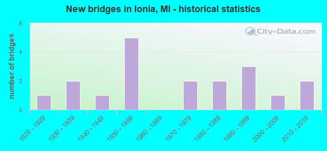
- New bridges - historical statistics
- 11920-1929
- 21930-1939
- 11940-1949
- 51950-1959
- 21970-1979
- 21980-1989
- 31990-1999
- 12000-2009
- 22010-2019


- Bridge Condition - Deck
- 9.1%Very good
- 54.5%Good
- 9.1%Satisfactory
- 27.3%Fair

- Bridge Condition - Superstructure
- 27.3%Very good
- 18.2%Good
- 36.4%Satisfactory
- 18.2%Fair

- Bridge Condition - Substructure
- 27.3%Very good
- 36.4%Good
- 9.1%Satisfactory
- 27.3%Fair

- Bridge Condition - Channel
- 28.6%Good
- 57.1%Satisfactory
- 14.3%Fair

- Bridge Condition - Culverts
- 60.0%Satisfactory
- 20.0%Fair
- 20.0%Poor
Find on map >> Show street view
Structure Number: 397, Location: 2.3 MI E OF M-65 (Lat: 44.047911, Lng: -83.759108), Route carried "on" structure: US 23, Year Built: 1931, Status: Open, Structure Length: 0.94m (3.08ft), Average Daily Traffic: 6,558 (year 2007), Truck Traffic: 5%, Average Future Daily Traffic: 7,417 (year 2018), Design Load: H 15, Features Intersected: BIG CREEK
Minimum Vertical Clearance: 30.48m (100.00ft), Kilometerpoint: 19.543, Lanes on structure: 2, Base Highway Network: Yes (Inventory Route: 106, Subroute: 3), Owner: State Highway Agency, Approaching Roadway Width: 11.5m (37.7ft), Material/Design: Concrete, Design/Construction: Tee Beam, Number Of Spans In Main Unit: 1, Length of Maximum Span: 9.4m (30.8ft), Curb-To-Curb Width: 10.6m (34.8ft), Out-to-Out Width: 11.5m (37.7ft)
Condition: Deck: Fair, Superstructure: Satisfactory, Substructure: Fair, Channel: Fair, Operating Rating: 78.4 metric tons, Method Used To Determine Operating Rating: Load Factor (LF) rating reported by rating factor (RF) method using MS18 loading, Inventory Rating: 47.0 metric tons, Method Used To Determine Inventory Rating: Load Factor (LF) rating reported by rating factor (RF) method using MS18 loading, Structural Evaluation: Somewhat better than minimum adequacy, Deck Geometry: Meets minimum limits, Waterway Adequacy: Equal to present minimum criteria, Approach Roadway Alignment: Somewhat better than minimum adequacy, Designated Inspection Frequency: Every 24 months, Inspection Date: December 2021, Deck Structure Type: Concrete Cast-file-Place, Wearing Surface/Protective System: Wearing Surface: Bituminous
Find on map >> Show street view
Structure Number: 397, Location: IN IONIA (Lat: 42.972272, Lng: -85.069297), Route carried "on" structure: State highway 66, Year Built: 1948, Status: Open, Structure Length: 11.43m (37.50ft), Average Daily Traffic: 17,638 (year 2015), Truck Traffic: 3%, Average Future Daily Traffic: 22,870 (year 2018), Design Load: HS 20, Features Intersected: GRAND RIVER
Minimum Vertical Clearance: 30.48m (100.00ft), Kilometerpoint: 22.493, Lanes on structure: 4, Owner: State Highway Agency, Approaching Roadway Width: 14.0m (45.9ft), Material/Design: Steel, Design/Construction: Stringer/Multi-beam, Number Of Spans In Main Unit: 5, Length of Maximum Span: 22.9m (75.1ft), Curb or Sidewalk Widths: Left: 1.6m (5.2ft), Right: 1.6m (5.2ft), Curb-To-Curb Width: 14.0m (45.9ft), Out-to-Out Width: 18.2m (59.7ft)
Condition: Deck: Good, Superstructure: Satisfactory, Substructure: Good, Channel: Satisfactory, Operating Rating: 65.1 metric tons, Method Used To Determine Operating Rating: Load Factor (LF) rating reported by rating factor (RF) method using MS18 loading, Inventory Rating: 38.9 metric tons, Method Used To Determine Inventory Rating: Load Factor (LF) rating reported by rating factor (RF) method using MS18 loading, Structural Evaluation: Equal to present minimum criteria, Deck Geometry: High priority of replacement, Waterway Adequacy: Equal to present desirable criteria, Approach Roadway Alignment: Equal to present desirable criteria, Designated Inspection Frequency: Every 24 months, Underwater Inspection Frequency: Every 60 months, Inspection Date: September 2021, Underwater Inspection Date: May 2020, Deck Structure Type: Concrete Cast-file-Place, Wearing Surface/Protective System: Wearing Surface: Latex Concrete
Find on map >> Show street view
Structure Number: 398, Location: @ MILE POST 68.4 (Lat: 42.879328, Lng: -85.055122), Route carried "on" structure: Interstate 96, Year Built: 1958, Status: Open, Structure Length: 0.61m (2.00ft), Average Daily Traffic: 33,978 (year 2007), Truck Traffic: 13%, Average Future Daily Traffic: 46,254 (year 2018), Design Load: HS 20+Mod, Features Intersected: LIBHART CREEK
Minimum Vertical Clearance: 30.48m (100.00ft), Kilometerpoint: 21.009, Lanes on structure: 4, Base Highway Network: Yes (Inventory Route: 50, Subroute: 10), Owner: State Highway Agency, Approaching Roadway Width: 11.0m (36.1ft), Material/Design: Concrete, Design/Construction: Culvert, Number Of Spans In Main Unit: 2, Length of Maximum Span: 2.7m (8.9ft), Out-to-Out Width: 70.1m (230.0ft)
Condition: Channel: Good, Culverts: Satisfactory, Operating Rating: 97.2 metric tons, Method Used To Determine Operating Rating: Load Factor (LF) rating reported by rating factor (RF) method using MS18 loading, Inventory Rating: 97.2 metric tons, Method Used To Determine Inventory Rating: Load Factor (LF) rating reported by rating factor (RF) method using MS18 loading, Structural Evaluation: Equal to present minimum criteria, Waterway Adequacy: Equal to present desirable criteria, Approach Roadway Alignment: Equal to present desirable criteria, Designated Inspection Frequency: Every 24 months, Inspection Date: January 2022
Find on map >> Show street view
Structure Number: 3985, Location: @ M-66 (Lat: 42.879358, Lng: -85.074808), Route carried "on" structure: State highway 66, Year Built: 1959, Status: Open, Structure Length: 8.21m (26.94ft), Average Daily Traffic: 10,500 (year 2016), Truck Traffic: 7%, Average Future Daily Traffic: 11,600 (year 2036), Design Load: HS 20, Features Intersected: I-96
Minimum Vertical Clearance: 30.48m (100.00ft), Kilometerpoint: 12.030, Lanes on structure: 2, Lanes under structure: 5, Base Highway Network: Yes (Inventory Route: 50, Subroute: 2), Owner: State Highway Agency, Approaching Roadway Width: 10.2m (33.5ft), Material/Design: Concrete continuous, Design/Construction: Tee Beam, Number Of Spans In Main Unit: 4, Length of Maximum Span: 24.6m (80.7ft), Curb-To-Curb Width: 9.9m (32.5ft), Out-to-Out Width: 11.0m (36.1ft)
Condition: Deck: Good, Superstructure: Good, Substructure: Good, Operating Rating: 63.8 metric tons, Method Used To Determine Operating Rating: Load Factor (LF) rating reported by rating factor (RF) method using MS18 loading, Inventory Rating: 37.9 metric tons, Method Used To Determine Inventory Rating: Load Factor (LF) rating reported by rating factor (RF) method using MS18 loading, Structural Evaluation: Better than present minimum criteria, Deck Geometry: Meets minimum limits, Underclear: Somewhat better than minimum adequacy, Approach Roadway Alignment: Better than present minimum criteria, Designated Inspection Frequency: Every 24 months, Inspection Date: October 2020, Deck Structure Type: Concrete Cast-file-Place, Wearing Surface/Protective System: Wearing Surface: Latex Concrete
Find on map >> Show street view
Structure Number: 3986, Location: @ M-66 (Lat: 42.879358, Lng: -85.075064), Route carried "on" structure: State highway 66, Year Built: 1959, Status: Open, Structure Length: 8.21m (26.94ft), Average Daily Traffic: 10,500 (year 2016), Truck Traffic: 7%, Average Future Daily Traffic: 11,600 (year 2036), Design Load: HS 20, Features Intersected: I-96
Minimum Vertical Clearance: 30.48m (100.00ft), Kilometerpoint: 0.541, Lanes on structure: 2, Lanes under structure: 5, Base Highway Network: Yes (Inventory Route: 334, Subroute: 1), Owner: State Highway Agency, Approaching Roadway Width: 10.2m (33.5ft), Material/Design: Concrete continuous, Design/Construction: Tee Beam, Number Of Spans In Main Unit: 4, Length of Maximum Span: 24.6m (80.7ft), Curb-To-Curb Width: 9.9m (32.5ft), Out-to-Out Width: 11.0m (36.1ft)
Condition: Deck: Good, Superstructure: Satisfactory, Substructure: Good, Operating Rating: 63.5 metric tons, Method Used To Determine Operating Rating: Load Factor (LF) rating reported by rating factor (RF) method using MS18 loading, Inventory Rating: 37.9 metric tons, Method Used To Determine Inventory Rating: Load Factor (LF) rating reported by rating factor (RF) method using MS18 loading, Structural Evaluation: Equal to present minimum criteria, Deck Geometry: Meets minimum limits, Underclear: Meets minimum limits, Approach Roadway Alignment: Better than present minimum criteria, Designated Inspection Frequency: Every 24 months, Inspection Date: October 2020, Deck Structure Type: Concrete Cast-file-Place, Wearing Surface/Protective System: Wearing Surface: Latex Concrete
Find on map >> Show street view
Structure Number: 4004, Location: 2.3 MI W OF IONIA (Lat: 42.977969, Lng: -85.115533), Route carried "on" structure: State highway 21, Year Built: 1930, Status: Open, Structure Length: 0.94m (3.08ft), Average Daily Traffic: 5,147 (year 2007), Truck Traffic: 6%, Average Future Daily Traffic: 7,530 (year 2018), Design Load: H 15, Features Intersected: BELLANY CREEK
Minimum Vertical Clearance: 30.48m (100.00ft), Kilometerpoint: 16.495, Lanes on structure: 2, Base Highway Network: Yes (Inventory Route: 50, Subroute: 9), Owner: State Highway Agency, Approaching Roadway Width: 12.2m (40.0ft), Skew: 3 degrees, Material/Design: Concrete continuous, Design/Construction: Culvert, Number Of Spans In Main Unit: 2, Length of Maximum Span: 4.8m (15.7ft), Curb-To-Curb Width: 11.0m (36.1ft), Out-to-Out Width: 19.2m (63.0ft)
Condition: Channel: Fair, Culverts: Satisfactory, Operating Rating: 54.5 metric tons, Method Used To Determine Operating Rating: Field evaluation and documented engineering judgment, Inventory Rating: 32.7 metric tons, Method Used To Determine Inventory Rating: Field evaluation and documented engineering judgment, Structural Evaluation: Equal to present minimum criteria, Deck Geometry: Meets minimum limits, Waterway Adequacy: Equal to present desirable criteria, Approach Roadway Alignment: Equal to present desirable criteria, Designated Inspection Frequency: Every 24 months, Inspection Date: December 2020
Find on map >> Show street view
Structure Number: 4009, Location: 2.6 MI E OF M-66 (Lat: 42.991611, Lng: -85.028553), Route carried "on" structure: State highway 21, Year Built: 1929, Status: Open, Structure Length: 1.52m (4.99ft), Average Daily Traffic: 8,456 (year 2007), Truck Traffic: 5%, Average Future Daily Traffic: 8,986 (year 2018), Design Load: H 15, Features Intersected: PRAIRIE CREEK
Minimum Vertical Clearance: 30.48m (100.00ft), Kilometerpoint: 13.171, Lanes on structure: 2, Owner: State Highway Agency, Approaching Roadway Width: 12.2m (40.0ft), Skew: 1 degrees, Material/Design: Steel, Design/Construction: Stringer/Multi-beam, Number Of Spans In Main Unit: 1, Length of Maximum Span: 15.2m (49.9ft), Curb or Sidewalk Widths: Left: 0.4m (1.3ft), Right: 0.4m (1.3ft), Curb-To-Curb Width: 12.2m (40.0ft), Out-to-Out Width: 13.8m (45.3ft)
Condition: Deck: Fair, Superstructure: Fair, Substructure: Fair, Channel: Satisfactory, Operating Rating: 60.9 metric tons, Method Used To Determine Operating Rating: Load Factor (LF) rating reported by rating factor (RF) method using MS18 loading, Inventory Rating: 36.6 metric tons, Method Used To Determine Inventory Rating: Load Factor (LF) rating reported by rating factor (RF) method using MS18 loading, Structural Evaluation: Somewhat better than minimum adequacy, Deck Geometry: Somewhat better than minimum adequacy, Waterway Adequacy: Equal to present desirable criteria, Approach Roadway Alignment: Better than present minimum criteria, Length Of Structure Improvement: 1.52m (4.99ft), Designated Inspection Frequency: Every 24 months, Inspection Date: December 2020, Bridge Improvement Cost: $45,000, Roadway Improvement Cost: $2,000, Total Project Cost: $27,000, Deck Structure Type: Concrete Cast-file-Place, Wearing Surface/Protective System: Wearing Surface: Bituminous
Find on map >> Show street view
Structure Number: 4041, Location: 1.2MI E M66 @ S LMT IONIA (Lat: 42.974819, Lng: -85.046717), Route carried "on" structure: ServiceCounty highway , Year Built: 2013, Status: Open, Structure Length: 11.46m (37.60ft), Average Daily Traffic: 4,512 (year 2013), Truck Traffic: 6%, Average Future Daily Traffic: 4,581 (year 2033), Design Load: HS 20+Mod, Features Intersected: GRAND RIVER, Facility Carried by Structure: CLEVELAND STREET
Minimum Vertical Clearance: 30.48m (100.00ft), Kilometerpoint: 0.307, Lanes on structure: 2, Owner: County Highway Agency, Approaching Roadway Width: 9.1m (29.9ft), Material/Design: Prestressed concrete, Design/Construction: Box Beam or Girders - Single/Spread, Number Of Spans In Main Unit: 4, Length of Maximum Span: 28.1m (92.2ft), Curb or Sidewalk Widths: Left: 0.5m (1.6ft), Right: 0.5m (1.6ft), Curb-To-Curb Width: 9.8m (32.2ft), Out-to-Out Width: 10.8m (35.4ft)
Condition: Deck: Good, Superstructure: Very good, Substructure: Very good, Channel: Good, Operating Rating: 78.4 metric tons, Method Used To Determine Operating Rating: Load and Resistance Factor Rating (LRFR) rating reported by rating factor(RF) method using HL-93 loadings, Inventory Rating: 60.6 metric tons, Method Used To Determine Inventory Rating: Load and Resistance Factor Rating (LRFR) rating reported by rating factor(RF) method using HL-93 loadings, Structural Evaluation: Equal to present desirable criteria, Deck Geometry: Meets minimum limits, Waterway Adequacy: Better than present minimum criteria, Approach Roadway Alignment: Better than present minimum criteria, Designated Inspection Frequency: Every 24 months, Inspection Date: October 2021, Deck Structure Type: Concrete Cast-file-Place, Wearing Surface/Protective System: Wearing Surface: Monolithic Concrete, Deck Protection: Epoxy Coated Reinforcing
Find on map >> Show street view
Structure Number: 4064, Location: 1.5 MI N 3.0 MI W OFIONIA (Lat: 43.009142, Lng: -85.155247), Route carried "on" structure: ServiceCounty highway , Year Built: 1994, Status: Open, Structure Length: 0.85m (2.79ft), Average Daily Traffic: 29 (year 2008), Average Future Daily Traffic: 34 (year 2028), Design Load: HS 20+Mod, Features Intersected: BELLAMY CREEK, Facility Carried by Structure: DILDINE ROAD
Minimum Vertical Clearance: 30.48m (100.00ft), Kilometerpoint: 0.768, Lanes on structure: 2, Owner: County Highway Agency, Approaching Roadway Width: 5.2m (17.1ft), Material/Design: Aluminum, Iron, Design/Construction: Culvert, Number Of Spans In Main Unit: 1, Length of Maximum Span: 8.5m (27.9ft)
Condition: Channel: Satisfactory, Culverts: Satisfactory, Operating Rating: 21.4 metric tons, Method Used To Determine Operating Rating: Load and Resistance Factor Rating (LRFR) rating reported by rating factor(RF) method using HL-93 loadings, Inventory Rating: 13.0 metric tons, Method Used To Determine Inventory Rating: Load and Resistance Factor Rating (LRFR) rating reported by rating factor(RF) method using HL-93 loadings, Structural Evaluation: Meets minimum limits, Waterway Adequacy: Equal to present minimum criteria, Approach Roadway Alignment: Equal to present desirable criteria, Designated Inspection Frequency: Every 24 months, Inspection Date: October 2020, Wearing Surface/Protective System: Wearing Surface: Gravel
Find on map >> Show street view
Structure Number: 4065, Location: 1.0 MILE EAST OF IONIA (Lat: 42.985372, Lng: -85.026286), Route carried "on" structure: ServiceCounty highway , Year Built: 1994, Status: Open, Structure Length: 2.87m (9.42ft), Average Daily Traffic: 805 (year 2008), Truck Traffic: 3%, Average Future Daily Traffic: 937 (year 2028), Design Load: HS 20, Features Intersected: PRAIRIE CREEK, Facility Carried by Structure: EAST MAIN STREET
Minimum Vertical Clearance: 30.48m (100.00ft), Kilometerpoint: 9.417, Lanes on structure: 2, Owner: County Highway Agency, Approaching Roadway Width: 9.1m (29.9ft), Material/Design: Prestressed concrete, Design/Construction: Box Beam or Girders - Multiple, Number Of Spans In Main Unit: 1, Length of Maximum Span: 28.7m (94.2ft), Curb or Sidewalk Widths: Left: 1.5m (4.9ft), Right: 1.5m (4.9ft), Curb-To-Curb Width: 9.4m (30.8ft), Out-to-Out Width: 13.3m (43.6ft)
Condition: Deck: Good, Superstructure: Very good, Substructure: Very good, Channel: Satisfactory, Operating Rating: 83.9 metric tons, Method Used To Determine Operating Rating: Load Factor (LF) rating reported by rating factor (RF) method using MS18 loading, Inventory Rating: 50.2 metric tons, Method Used To Determine Inventory Rating: Load Factor (LF) rating reported by rating factor (RF) method using MS18 loading, Structural Evaluation: Equal to present desirable criteria, Deck Geometry: Equal to present minimum criteria, Waterway Adequacy: Equal to present desirable criteria, Approach Roadway Alignment: Equal to present minimum criteria, Designated Inspection Frequency: Every 24 months, Inspection Date: October 2020, Deck Structure Type: Concrete Cast-file-Place, Wearing Surface/Protective System: Wearing Surface: Monolithic Concrete
Find on map >> Show street view
Structure Number: 4066, Location: 1.0 MI N 1.5 MI E IONIA (Lat: 43.012244, Lng: -85.016733), Route carried "on" structure: ServiceCounty highway , Year Built: 1995, Status: Open, Structure Length: 1.95m (6.40ft), Average Daily Traffic: 145 (year 2008), Truck Traffic: 10%, Average Future Daily Traffic: 169 (year 2028), Design Load: HS 20, Features Intersected: PRAIRIE CREEK, Facility Carried by Structure: WELCH ROAD
Minimum Vertical Clearance: 30.48m (100.00ft), Kilometerpoint: 3.306, Lanes on structure: 2, Owner: County Highway Agency, Approaching Roadway Width: 6.1m (20.0ft), Material/Design: Wood or Timber, Design/Construction: Slab, Number Of Spans In Main Unit: 3, Length of Maximum Span: 7.3m (24.0ft), Curb-To-Curb Width: 9.1m (29.9ft), Out-to-Out Width: 9.7m (31.8ft)
Condition: Deck: Good, Superstructure: Good, Substructure: Good, Channel: Satisfactory, Operating Rating: 65.4 metric tons, Method Used To Determine Operating Rating: Allowable Stress (AS) rating reported by rating factor (RF) method using MS18 loading, Inventory Rating: 46.3 metric tons, Method Used To Determine Inventory Rating: Allowable Stress (AS) rating reported by rating factor (RF) method using MS18 loading, Structural Evaluation: Better than present minimum criteria, Deck Geometry: Equal to present minimum criteria, Waterway Adequacy: Equal to present desirable criteria, Approach Roadway Alignment: Somewhat better than minimum adequacy, Designated Inspection Frequency: Every 24 months, Inspection Date: October 2020, Deck Structure Type: Wood or Timber, Wearing Surface/Protective System: Wearing Surface: Bituminous
Find on map >> Show street view
Structure Number: 4067, Location: 1.0 MILE EAST OF IONIA (Lat: 42.993156, Lng: -85.027053), Route carried "on" structure: ServiceCounty highway , Year Built: 2004, Status: Open, Structure Length: 2.01m (6.59ft), Average Daily Traffic: 490 (year 2008), Truck Traffic: 2%, Average Future Daily Traffic: 570 (year 2028), Design Load: HS 20+Mod, Features Intersected: PRAIRIE CREEK, Facility Carried by Structure: PRAIRIE CREEK ROAD
Minimum Vertical Clearance: 30.48m (100.00ft), Kilometerpoint: 0.109, Lanes on structure: 2, Owner: County Highway Agency, Approaching Roadway Width: 8.5m (27.9ft), Skew: 1 degrees, Material/Design: Prestressed concrete, Design/Construction: Box Beam or Girders - Multiple, Number Of Spans In Main Unit: 1, Length of Maximum Span: 18.9m (62.0ft), Curb-To-Curb Width: 8.5m (27.9ft), Out-to-Out Width: 9.6m (31.5ft)
Condition: Deck: Very good, Superstructure: Very good, Substructure: Very good, Channel: Good, Operating Rating: 76.1 metric tons, Method Used To Determine Operating Rating: Load Factor (LF) rating reported by rating factor (RF) method using MS18 loading, Inventory Rating: 45.7 metric tons, Method Used To Determine Inventory Rating: Load Factor (LF) rating reported by rating factor (RF) method using MS18 loading, Structural Evaluation: Equal to present desirable criteria, Deck Geometry: Somewhat better than minimum adequacy, Waterway Adequacy: Better than present minimum criteria, Approach Roadway Alignment: High priority of corrective action, Designated Inspection Frequency: Every 24 months, Inspection Date: October 2020, Deck Structure Type: Concrete Cast-file-Place, Wearing Surface/Protective System: Wearing Surface: Monolithic Concrete, Deck Protection: Epoxy Coated Reinforcing
Find on map >> Show street view
Structure Number: 4068, Location: 1.0 MILE EAST OF IONIA (Lat: 43.000236, Lng: -85.024914), Route carried "on" structure: ServiceCounty highway , Year Built: 1971, Status: Posted for load, Structure Length: 2.37m (7.78ft), Average Daily Traffic: 326 (year 2008), Truck Traffic: 4%, Average Future Daily Traffic: 379 (year 2028), Design Load: HS 20+Mod, Features Intersected: PRAIRIE CREEK, Facility Carried by Structure: PRAIRIE CREEK ROAD
Minimum Vertical Clearance: 30.48m (100.00ft), Kilometerpoint: 0.979, Lanes on structure: 2, Owner: County Highway Agency, Approaching Roadway Width: 7.3m (24.0ft), Skew: 4 degrees, Material/Design: Wood or Timber, Design/Construction: Slab, Number Of Spans In Main Unit: 3, Length of Maximum Span: 7.9m (25.9ft), Curb-To-Curb Width: 8.5m (27.9ft), Out-to-Out Width: 8.9m (29.2ft)
Condition: Deck: Satisfactory, Superstructure: Satisfactory, Substructure: Satisfactory, Channel: Good, Operating Rating: 37.9 metric tons, Method Used To Determine Operating Rating: Allowable Stress (AS) rating reported by rating factor (RF) method using MS18 loading, Inventory Rating: 25.6 metric tons, Method Used To Determine Inventory Rating: Allowable Stress (AS) rating reported by rating factor (RF) method using MS18 loading, Structural Evaluation: Equal to present minimum criteria, Deck Geometry: Equal to present minimum criteria, Waterway Adequacy: Better than present minimum criteria, Approach Roadway Alignment: Equal to present minimum criteria, Bridge Posting: Required (Relationship of Operating Rating to Maximum Legal Load: 10.0 - 19.9% below), Designated Inspection Frequency: Every 24 months, Inspection Date: October 2020, Deck Structure Type: Wood or Timber, Wearing Surface/Protective System: Wearing Surface: Bituminous
Find on map >> Show street view
Structure Number: 4069, Location: 1.0 MI E 0.5 MI N IONIA (Lat: 43.004336, Lng: -85.024947), Route carried "on" structure: ServiceCounty highway , Year Built: 1979, Status: Posted for load, Structure Length: 3.17m (10.40ft), Average Daily Traffic: 227 (year 2008), Truck Traffic: 4%, Average Future Daily Traffic: 264 (year 2028), Design Load: HS 20+Mod, Features Intersected: PRAIRIE CREEK, Facility Carried by Structure: PRAIRIE CREEK ROAD
Minimum Vertical Clearance: 30.48m (100.00ft), Kilometerpoint: 1.502, Lanes on structure: 2, Owner: County Highway Agency, Approaching Roadway Width: 9.8m (32.2ft), Skew: 4 degrees, Material/Design: Wood or Timber, Design/Construction: Slab, Number Of Spans In Main Unit: 4, Length of Maximum Span: 7.9m (25.9ft), Curb-To-Curb Width: 9.1m (29.9ft), Out-to-Out Width: 9.7m (31.8ft)
Condition: Deck: Fair, Superstructure: Fair, Substructure: Fair, Channel: Satisfactory, Operating Rating: 36.9 metric tons, Method Used To Determine Operating Rating: Allowable Stress (AS) rating reported by rating factor (RF) method using MS18 loading, Inventory Rating: 25.3 metric tons, Method Used To Determine Inventory Rating: Allowable Stress (AS) rating reported by rating factor (RF) method using MS18 loading, Structural Evaluation: Somewhat better than minimum adequacy, Deck Geometry: Equal to present minimum criteria, Waterway Adequacy: Better than present minimum criteria, Approach Roadway Alignment: Equal to present minimum criteria, Bridge Posting: Required (Relationship of Operating Rating to Maximum Legal Load: 20.0 - 29.9% below), Designated Inspection Frequency: Every 24 months, Inspection Date: October 2020, Deck Structure Type: Wood or Timber, Wearing Surface/Protective System: Wearing Surface: Bituminous
Find on map >> Show street view
Structure Number: 4083, Location: 4.0 MI S 0.5 MI E IONIA (Lat: 42.900386, Lng: -85.038194), Route carried "on" structure: ServiceCounty highway , Year Built: 1982, Status: Open, Structure Length: 1.20m (3.94ft), Average Daily Traffic: 128 (year 2008), Truck Traffic: 17%, Average Future Daily Traffic: 149 (year 2028), Design Load: HS 20+Mod, Features Intersected: LIBHART CREEK, Facility Carried by Structure: PECK LAKE ROAD
Minimum Vertical Clearance: 30.48m (100.00ft), Kilometerpoint: 22.398, Lanes on structure: 2, Owner: County Highway Agency, Approaching Roadway Width: 9.1m (29.9ft), Material/Design: Steel, Design/Construction: Culvert, Number Of Spans In Main Unit: 4, Length of Maximum Span: 2.4m (7.9ft)
Condition: Channel: Satisfactory, Culverts: Poor, Operating Rating: 23.0 metric tons, Method Used To Determine Operating Rating: Load Factor (LF) rating reported by rating factor (RF) method using MS18 loading, Inventory Rating: 13.9 metric tons, Method Used To Determine Inventory Rating: Load Factor (LF) rating reported by rating factor (RF) method using MS18 loading, Structural Evaluation: Meets minimum limits, Waterway Adequacy: Equal to present minimum criteria, Approach Roadway Alignment: Better than present minimum criteria, Designated Inspection Frequency: Every 24 months, Inspection Date: October 2020
Find on map >> Show street view
Structure Number: 4087, Location: 2.0 MI E 3.0 MI S IONIA (Lat: 42.914700, Lng: -85.006181), Route carried "on" structure: ServiceCounty highway , Year Built: 1982, Status: Open, Structure Length: 0.91m (2.99ft), Average Daily Traffic: 112 (year 2008), Truck Traffic: 16%, Average Future Daily Traffic: 130 (year 2028), Design Load: HS 20+Mod, Features Intersected: LIBHART CREEK, Facility Carried by Structure: GOODWIN ROAD
Minimum Vertical Clearance: 30.48m (100.00ft), Kilometerpoint: 1.465, Lanes on structure: 2, Owner: County Highway Agency, Approaching Roadway Width: 6.7m (22.0ft), Skew: 2 degrees, Material/Design: Steel, Design/Construction: Culvert, Number Of Spans In Main Unit: 3, Length of Maximum Span: 3.0m (9.8ft)
Condition: Channel: Satisfactory, Culverts: Fair, Operating Rating: 72.3 metric tons, Method Used To Determine Operating Rating: Load Factor (LF) rating reported by rating factor (RF) method using MS18 loading, Inventory Rating: 43.4 metric tons, Method Used To Determine Inventory Rating: Load Factor (LF) rating reported by rating factor (RF) method using MS18 loading, Structural Evaluation: Somewhat better than minimum adequacy, Waterway Adequacy: Equal to present minimum criteria, Approach Roadway Alignment: Better than present minimum criteria, Designated Inspection Frequency: Every 24 months, Inspection Date: October 2020
Find on map >> Show street view
Structure Number: 3985, Location: @ M-66 (Lat: 42.879358, Lng: -85.074808), Route carried "under" structure: Interstate 96, Year Built: 1959, Structure Length: 0. m, Average Daily Traffic: 37,200 (year 2016), Truck Traffic: 12%, Features Intersected: I-96, Facility Carried by Structure: M-66 NB
Minimum Vertical Clearance: 5.41m (17.75ft), Kilometerpoint: 19.396, Lanes on structure: 2, Lanes under structure: 5, Material/Design: Concrete continuous, Design/Construction: Tee Beam, Length of Maximum Span: 24.6m (80.7ft)
Find on map >> Show street view
Structure Number: 3986, Location: @ M-66 (Lat: 42.879358, Lng: -85.075064), Route carried "under" structure: Interstate 96, Year Built: 1959, Structure Length: 0. m, Average Daily Traffic: 37,200 (year 2016), Truck Traffic: 12%, Features Intersected: I-96, Facility Carried by Structure: M-66 SB
Minimum Vertical Clearance: 5.13m (16.83ft), Kilometerpoint: 19.379, Lanes on structure: 2, Lanes under structure: 5, Material/Design: Concrete continuous, Design/Construction: Tee Beam, Length of Maximum Span: 24.6m (80.7ft)
Find on map >> Show street view
Structure Number: 13869, Location: IN IONIA (Lat: 42.980611, Lng: -85.070222), Route carried "under" structure: State highway 66, Year Built: 2015, Structure Length: 0. m, Average Daily Traffic: 12,158 (year 2013), Truck Traffic: 1%, Features Intersected: M-66, Facility Carried by Structure: FM GRND RIV VAL TR
Minimum Vertical Clearance: 5.49m (18.01ft), Kilometerpoint: 0.000, Lanes under structure: 4, Material/Design: Steel, Design/Construction: Truss - Thru, Length of Maximum Span: 23.8m (78.1ft)