Bridge Statistics for Ilion, New York (NY)
Condition, Traffic, Stress, Structural Evaluation, Project Costs
- National Bridge Inventory (NBI) Statistics
- 17Number of bridges
- 256ft / 78.2mTotal length
- $23,077,000Total costs
- 82,147Total average daily traffic
- 4,596Total average daily truck traffic
- National Bridge Inventory (NBI) Registered Bridges for Ilion
- No street view available for this location
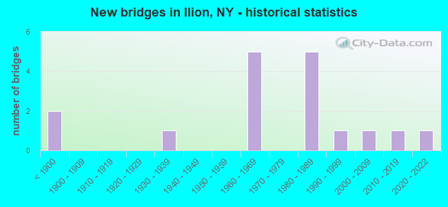
- New bridges - historical statistics
- 2Before 1900
- 11930-1939
- 51960-1969
- 51980-1989
- 11990-1999
- 12000-2009
- 12010-2019
- 12020-2022


- Bridge Condition - Deck
- 9.1%Excellent
- 36.4%Good
- 54.5%Satisfactory

- Bridge Condition - Superstructure
- 15.4%Excellent
- 30.8%Very good
- 15.4%Good
- 30.8%Satisfactory
- 7.7%Fair

- Bridge Condition - Substructure
- 15.4%Excellent
- 53.8%Very good
- 15.4%Good
- 15.4%Satisfactory

- Bridge Condition - Channel
- 10.0%Excellent
- 20.0%Very good
- 30.0%Good
- 40.0%Fair
Find on map >> Show street view
Structure Number: 100272, Location: IN VILLAGE OF ILION (Lat: 43.017028, Lng: -75.039542), Route carried "on" structure: City street , Year Built: 1937, Year Reconstructed: 2016, Status: Open, Structure Length: 1.92m (6.30ft), Average Daily Traffic: 6,356 (year 2020), Truck Traffic: 3%, Average Future Daily Traffic: 7,721 (year 2040), Design Load: HL 93, Features Intersected: STEELE CREEK, Facility Carried by Structure: WEST MAIN STREET
Minimum Vertical Clearance: 30+ m (98+ ft), Kilometerpoint: 1.142, Lanes on structure: 2, Owner: Town or Township Highway Agency, Approaching Roadway Width: 10.7m (35.1ft), Skew: 4 degrees, Material/Design: Prestressed concrete, Design/Construction: Box Beam or Girders - Multiple, Number Of Spans In Main Unit: 1, Length of Maximum Span: 17.4m (57.1ft), Curb or Sidewalk Widths: Left: 1.6m (5.2ft), Right: 1.6m (5.2ft), Curb-To-Curb Width: 10.7m (35.1ft), Out-to-Out Width: 15.0m (49.2ft)
Condition: Deck: Good, Superstructure: Very good, Substructure: Good, Channel: Very good, Operating Rating: 45.4 metric tons, Method Used To Determine Operating Rating: Load Factor (LF), Inventory Rating: 26.3 metric tons, Method Used To Determine Inventory Rating: Load Factor (LF), Structural Evaluation: Equal to present minimum criteria, Deck Geometry: Meets minimum limits, Waterway Adequacy: Somewhat better than minimum adequacy, Approach Roadway Alignment: Equal to present desirable criteria, Length Of Structure Improvement: 1.92m (6.30ft), Designated Inspection Frequency: Every 24 months, Inspection Date: October 2020, Bridge Improvement Cost: $670,000, Roadway Improvement Cost: $392,000, Total Project Cost: $1,063,000 ( Estimate for 2021), Wearing Surface/Protective System: Wearing Surface: Bituminous
Find on map >> Show street view
Structure Number: 102649, Location: 07MI S JCT RTS 5S+51 (Lat: 43.008975, Lng: -75.041239), Route carried "on" structure: State highway 51, Year Built: 1899, Status: Open, Structure Length: 1.13m (3.71ft), Average Daily Traffic: 3,017 (year 2020), Truck Traffic: 7%, Average Future Daily Traffic: 3,665 (year 2040), Features Intersected: STEELE CREEK
Minimum Vertical Clearance: 30+ m (98+ ft), Kilometerpoint: 25.438, Lanes on structure: 2, Base Highway Network: Yes, Owner: State Highway Agency, Approaching Roadway Width: 9.4m (30.8ft), Material/Design: Masonry, Design/Construction: Arch - Deck, Number Of Spans In Main Unit: 1, Length of Maximum Span: 9.1m (29.9ft), Curb or Sidewalk Widths: Left: 3.3m (10.8ft), Right: 4.9m (16.1ft), Curb-To-Curb Width: 9.4m (30.8ft), Out-to-Out Width: 19.0m (62.3ft)
Condition: Deck: Satisfactory, Superstructure: Satisfactory, Substructure: Satisfactory, Channel: Fair, Operating Rating: 47.4 metric tons, Method Used To Determine Operating Rating: Field evaluation and documented engineering judgment, Inventory Rating: 21.4 metric tons, Method Used To Determine Inventory Rating: Field evaluation and documented engineering judgment, Structural Evaluation: Somewhat better than minimum adequacy, Deck Geometry: Meets minimum limits, Waterway Adequacy: Meets minimum limits, Approach Roadway Alignment: Equal to present desirable criteria, Length Of Structure Improvement: 1.12m (3.67ft), Designated Inspection Frequency: Every 24 months, Inspection Date: August 2020, Bridge Improvement Cost: $308,000, Roadway Improvement Cost: $180,000, Total Project Cost: $488,000 ( Estimate for 2021), Wearing Surface/Protective System: Wearing Surface: Bituminous
Find on map >> Show street view
Structure Number: 107363, Location: 2.8 MI W JCT SH 5S & SH28 (Lat: 43.023325, Lng: -75.053167), Route carried "on" structure: State highway 5S, Year Built: 1987, Status: Open, Structure Length: 6.13m (20.11ft), Average Daily Traffic: 9,224 (year 2018), Truck Traffic: 6%, Average Future Daily Traffic: 11,511 (year 2040), Design Load: HS 20, Features Intersected: W MAIN ST/ ACME R
Minimum Vertical Clearance: 30+ m (98+ ft), Kilometerpoint: 13.644, Lanes on structure: 2, Lanes under structure: 4, Base Highway Network: Yes, Owner: State Highway Agency, Approaching Roadway Width: 13.4m (44.0ft), Skew: 23 degrees, Material/Design: Steel, Design/Construction: Stringer/Multi-beam, Number Of Spans In Main Unit: 1, Length of Maximum Span: 59.4m (194.9ft), Curb-To-Curb Width: 13.3m (43.6ft), Out-to-Out Width: 14.2m (46.6ft)
Condition: Deck: Good, Superstructure: Very good, Substructure: Very good, Operating Rating: 92.5 metric tons, Method Used To Determine Operating Rating: Load Factor (LF), Inventory Rating: 55.3 metric tons, Method Used To Determine Inventory Rating: Load Factor (LF), Structural Evaluation: Equal to present desirable criteria, Deck Geometry: Somewhat better than minimum adequacy, Underclear: High priority of corrective action, Approach Roadway Alignment: Equal to present desirable criteria, Length Of Structure Improvement: 6.12m (20.08ft), Designated Inspection Frequency: Every 24 months, Inspection Date: April 2021, Bridge Improvement Cost: $1,471,000, Roadway Improvement Cost: $861,000, Total Project Cost: $2,332,000 ( Estimate for 2021), Deck Structure Type: Concrete Cast-file-Place, Wearing Surface/Protective System: Wearing Surface: Integral Concrete, Deck Protection: Epoxy Coated Reinforcing
Find on map >> Show street view
Structure Number: 107364, Location: 0.6MI W INSECT RTS 5S &51 (Lat: 43.021811, Lng: -75.043861), Route carried "on" structure: State highway 5S, Year Built: 1988, Status: Open, Structure Length: 3.90m (12.80ft), Average Daily Traffic: 12,210 (year 2020), Truck Traffic: 7%, Average Future Daily Traffic: 15,238 (year 2040), Design Load: HS 20, Features Intersected: STEELE CREEK
Minimum Vertical Clearance: 30+ m (98+ ft), Kilometerpoint: 14.449, Lanes on structure: 3, Base Highway Network: Yes, Owner: State Highway Agency, Approaching Roadway Width: 16.8m (55.1ft), Material/Design: Steel, Design/Construction: Stringer/Multi-beam, Number Of Spans In Main Unit: 1, Length of Maximum Span: 38.1m (125.0ft), Curb-To-Curb Width: 17.1m (56.1ft), Out-to-Out Width: 17.8m (58.4ft)
Condition: Deck: Satisfactory, Superstructure: Very good, Substructure: Very good, Channel: Good, Operating Rating: 46.3 metric tons, Method Used To Determine Operating Rating: Load and Resistance Factor Rating (LRFR) rating reported by rating factor(RF) method using HL-93 loadings, Inventory Rating: 36.0 metric tons, Method Used To Determine Inventory Rating: Load and Resistance Factor Rating (LRFR) rating reported by rating factor(RF) method using HL-93 loadings, Structural Evaluation: Equal to present desirable criteria, Deck Geometry: Equal to present minimum criteria, Waterway Adequacy: High priority of corrective action, Approach Roadway Alignment: Equal to present desirable criteria, Length Of Structure Improvement: 3.90m (12.80ft), Designated Inspection Frequency: Every 24 months, Inspection Date: July 2021, Bridge Improvement Cost: $1,159,000, Roadway Improvement Cost: $679,000, Total Project Cost: $1,838,000 ( Estimate for 2021), Deck Structure Type: Concrete Cast-file-Place, Wearing Surface/Protective System: Wearing Surface: Integral Concrete, Deck Protection: Epoxy Coated Reinforcing
Find on map >> Show street view
Structure Number: 107402, Location: 0.3M N RTS 5S & 51-OVER51 (Lat: 43.020106, Lng: -75.031331), Route carried "on" structure: State highway 5S, Year Built: 1989, Status: Open, Structure Length: 3.54m (11.61ft), Average Daily Traffic: 10,330 (year 2020), Truck Traffic: 8%, Average Future Daily Traffic: 12,891 (year 2040), Design Load: HS 20, Features Intersected: RTE 51
Minimum Vertical Clearance: 30+ m (98+ ft), Kilometerpoint: 15.543, Lanes on structure: 3, Lanes under structure: 3, Base Highway Network: Yes, Owner: State Highway Agency, Approaching Roadway Width: 12.8m (42.0ft), Material/Design: Steel, Design/Construction: Stringer/Multi-beam, Number Of Spans In Main Unit: 1, Length of Maximum Span: 34.1m (111.9ft), Curb-To-Curb Width: 12.9m (42.3ft), Out-to-Out Width: 15.4m (50.5ft)
Condition: Deck: Satisfactory, Superstructure: Very good, Substructure: Very good, Operating Rating: 88.9 metric tons, Method Used To Determine Operating Rating: Load Factor (LF), Inventory Rating: 52.6 metric tons, Method Used To Determine Inventory Rating: Load Factor (LF), Structural Evaluation: Equal to present desirable criteria, Deck Geometry: High priority of replacement, Underclear: Equal to present minimum criteria, Approach Roadway Alignment: Equal to present desirable criteria, Length Of Structure Improvement: 3.53m (11.58ft), Designated Inspection Frequency: Every 24 months, Inspection Date: March 2021, Bridge Improvement Cost: $1,054,000, Roadway Improvement Cost: $617,000, Total Project Cost: $1,671,000 ( Estimate for 2021), Deck Structure Type: Concrete Cast-file-Place, Wearing Surface/Protective System: Wearing Surface: Integral Concrete, Deck Protection: Epoxy Coated Reinforcing
Find on map >> Show street view
Structure Number: 107452, Location: .75 MI W OF ROUTE 8 (Lat: 43.013269, Lng: -75.012689), Route carried "on" structure: State highway 5S, Year Built: 1991, Status: Open, Structure Length: 3.72m (12.20ft), Average Daily Traffic: 10,330 (year 2020), Truck Traffic: 8%, Average Future Daily Traffic: 12,891 (year 2040), Design Load: HS 20, Features Intersected: FULMER CREEK
Minimum Vertical Clearance: 30+ m (98+ ft), Kilometerpoint: 17.248, Lanes on structure: 2, Base Highway Network: Yes, Owner: State Highway Agency, Approaching Roadway Width: 12.2m (40.0ft), Skew: 1 degrees, Material/Design: Steel, Design/Construction: Stringer/Multi-beam, Number Of Spans In Main Unit: 1, Length of Maximum Span: 36.5m (119.8ft), Curb-To-Curb Width: 12.2m (40.0ft), Out-to-Out Width: 12.8m (42.0ft)
Condition: Deck: Good, Superstructure: Good, Substructure: Very good, Channel: Good, Operating Rating: 76.2 metric tons, Method Used To Determine Operating Rating: Load Factor (LF), Inventory Rating: 36.3 metric tons, Method Used To Determine Inventory Rating: Load Factor (LF), Structural Evaluation: Better than present minimum criteria, Deck Geometry: Somewhat better than minimum adequacy, Waterway Adequacy: Equal to present minimum criteria, Approach Roadway Alignment: Equal to present desirable criteria, Length Of Structure Improvement: 3.71m (12.17ft), Designated Inspection Frequency: Every 24 months, Inspection Date: October 2021, Bridge Improvement Cost: $812,000, Roadway Improvement Cost: $475,000, Total Project Cost: $1,287,000 ( Estimate for 2021), Deck Structure Type: Concrete Cast-file-Place, Wearing Surface/Protective System: Wearing Surface: Integral Concrete, Deck Protection: Epoxy Coated Reinforcing
Find on map >> Show street view
Structure Number: 109423, Location: 10MI W JCT RTS 51+5S (Lat: 43.022767, Lng: -75.053950), Route carried "on" structure: Ramp State highway 5S, Year Built: 1966, Status: Open, Structure Length: 0.70m (2.30ft), Average Daily Traffic: 1,885 (year 2018), Truck Traffic: 10%, Average Future Daily Traffic: 2,352 (year 2040), Design Load: HS 20, Features Intersected: MCGOWAN CREEK
Minimum Vertical Clearance: 30+ m (98+ ft), Kilometerpoint: 0.740, Lanes on structure: 1, Owner: State Highway Agency, Approaching Roadway Width: 7.6m (24.9ft), Skew: 2 degrees, Material/Design: Steel, Design/Construction: Culvert, Number Of Spans In Main Unit: 1, Length of Maximum Span: 6.7m (22.0ft)
Condition: Channel: Good, Culverts: Good, Operating Rating: 77.3 metric tons, Method Used To Determine Operating Rating: Field evaluation and documented engineering judgment, Inventory Rating: 32.7 metric tons, Method Used To Determine Inventory Rating: Field evaluation and documented engineering judgment, Structural Evaluation: Better than present minimum criteria, Waterway Adequacy: High priority of replacement, Approach Roadway Alignment: Equal to present desirable criteria, Length Of Structure Improvement: 0.70m (2.30ft), Designated Inspection Frequency: Every 24 months, Inspection Date: April 2020, Bridge Improvement Cost: $104,000, Roadway Improvement Cost: $61,000, Total Project Cost: $165,000 ( Estimate for 2021), Wearing Surface/Protective System: Wearing Surface: Bituminous
Find on map >> Show street view
Structure Number: 226684, Location: AT VILLAGE OF ILION (Lat: 43.002672, Lng: -75.043886), Route carried "on" structure: City street , Year Built: 2020, Status: Open, Structure Length: 2.53m (8.30ft), Average Daily Traffic: 328 (year 2017), Truck Traffic: 1%, Average Future Daily Traffic: 459 (year 2037), Design Load: HL 93, Features Intersected: STEELE CREEK, Facility Carried by Structure: RICHFIELD STREET
Minimum Vertical Clearance: 30+ m (98+ ft), Kilometerpoint: 0.064, Lanes on structure: 2, Owner: Town or Township Highway Agency, Approaching Roadway Width: 7.3m (24.0ft), Material/Design: Prestressed concrete, Design/Construction: Box Beam or Girders - Multiple, Number Of Spans In Main Unit: 1, Length of Maximum Span: 24.4m (80.1ft), Curb or Sidewalk Widths: Left: 1.5m (4.9ft), Right: 1.5m (4.9ft), Curb-To-Curb Width: 7.3m (24.0ft), Out-to-Out Width: 11.6m (38.1ft)
Condition: Deck: Excellent, Superstructure: Excellent, Substructure: Excellent, Channel: Fair, Operating Rating: 93.0 metric tons, Method Used To Determine Operating Rating: Load and Resistance Factor Rating (LRFR) rating reported by rating factor(RF) method using HL-93 loadings, Inventory Rating: 71.6 metric tons, Method Used To Determine Inventory Rating: Load and Resistance Factor Rating (LRFR) rating reported by rating factor(RF) method using HL-93 loadings, Structural Evaluation: Superior to present desirable criteria, Deck Geometry: Somewhat better than minimum adequacy, Waterway Adequacy: Equal to present minimum criteria, Approach Roadway Alignment: Equal to present minimum criteria, Length Of Structure Improvement: 1.76m (5.77ft), Designated Inspection Frequency: Every 24 months, Inspection Date: March 2021, Bridge Improvement Cost: $270,000, Roadway Improvement Cost: $158,000, Total Project Cost: $428,000 ( Estimate for 2021), Deck Structure Type: Concrete Cast-file-Place, Wearing Surface/Protective System: Wearing Surface: Integral Concrete, Deck Protection: Epoxy Coated Reinforcing
Find on map >> Show street view
Structure Number: 226686, Location: VILLAGE OF ILION (Lat: 43.012500, Lng: -75.041006), Route carried "on" structure: City street , Year Built: 2007, Status: Open, Structure Length: 0.94m (3.08ft), Average Daily Traffic: 420 (year 2017), Truck Traffic: 4%, Average Future Daily Traffic: 588 (year 2037), Design Load: HS 25 or greater, Features Intersected: STEELE CREEK, Facility Carried by Structure: THIRD STREET
Minimum Vertical Clearance: 30+ m (98+ ft), Kilometerpoint: 0.193, Lanes on structure: 2, Owner: Town or Township Highway Agency, Approaching Roadway Width: 7.9m (25.9ft), Material/Design: Concrete, Design/Construction: Frame, Number Of Spans In Main Unit: 1, Length of Maximum Span: 9.0m (29.5ft), Curb or Sidewalk Widths: Left: 3.5m (11.5ft), Right: 3.5m (11.5ft), Curb-To-Curb Width: 7.9m (25.9ft), Out-to-Out Width: 16.0m (52.5ft)
Condition: Superstructure: Good, Substructure: Excellent, Channel: Fair, Operating Rating: 78.0 metric tons, Method Used To Determine Operating Rating: Load Factor (LF), Inventory Rating: 47.2 metric tons, Method Used To Determine Inventory Rating: Load Factor (LF), Structural Evaluation: Better than present minimum criteria, Deck Geometry: Somewhat better than minimum adequacy, Waterway Adequacy: Meets minimum limits, Approach Roadway Alignment: Equal to present desirable criteria, Length Of Structure Improvement: 0.94m (3.08ft), Designated Inspection Frequency: Every 24 months, Inspection Date: August 2021, Bridge Improvement Cost: $562,000, Roadway Improvement Cost: $329,000, Total Project Cost: $891,000 ( Estimate for 2021)
Find on map >> Show street view
Structure Number: 226687, Location: AT VILLAGE OF ILION (Lat: 43.013783, Lng: -75.040614), Route carried "on" structure: City street , Year Built: 1890, Status: Open, Structure Length: 1.52m (4.99ft), Average Daily Traffic: 3,306 (year 2018), Truck Traffic: 2%, Average Future Daily Traffic: 4,090 (year 2040), Features Intersected: STEELE CREEK, Facility Carried by Structure: SECOND STREET
Minimum Vertical Clearance: 30+ m (98+ ft), Kilometerpoint: 1.255, Lanes on structure: 2, Owner: Town or Township Highway Agency, Approaching Roadway Width: 8.2m (26.9ft), Skew: 1 degrees, Material/Design: Masonry, Design/Construction: Arch - Deck, Number Of Spans In Main Unit: 1, Length of Maximum Span: 7.9m (25.9ft), Curb or Sidewalk Widths: Left: 3.7m (12.1ft), Right: 3.4m (11.2ft), Curb-To-Curb Width: 8.1m (26.6ft), Out-to-Out Width: 16.6m (54.5ft)
Condition: Superstructure: Fair, Substructure: Satisfactory, Channel: Fair, Operating Rating: 45.4 metric tons, Method Used To Determine Operating Rating: Load Factor (LF), Inventory Rating: 29.0 metric tons, Method Used To Determine Inventory Rating: Load Factor (LF), Structural Evaluation: Somewhat better than minimum adequacy, Deck Geometry: High priority of corrective action, Waterway Adequacy: Meets minimum limits, Approach Roadway Alignment: Equal to present minimum criteria, Length Of Structure Improvement: 1.52m (4.99ft), Designated Inspection Frequency: Every 24 months, Inspection Date: June 2021, Bridge Improvement Cost: $451,000, Roadway Improvement Cost: $264,000, Total Project Cost: $715,000 ( Estimate for 2021)
Find on map >> Show street view
Structure Number: 227085, Location: In Ilion (Lat: 43.006531, Lng: -75.041561), Route carried "on" structure: City street , Year Built: 2012, Status: Open, Structure Length: 1.43m (4.69ft), Truck Traffic: 5%, Design Load: HL 93, Features Intersected: STEELE CREEK, Facility Carried by Structure: FREDRICK STREET
Minimum Vertical Clearance: 30+ m (98+ ft), Kilometerpoint: 0.129, Lanes on structure: 2, Owner: Town or Township Highway Agency, Approaching Roadway Width: 7.9m (25.9ft), Skew: 1 degrees, Material/Design: Prestressed concrete, Design/Construction: Box Beam or Girders - Multiple, Number Of Spans In Main Unit: 1, Length of Maximum Span: 13.4m (44.0ft), Curb or Sidewalk Widths: Left: 1.8m (5.9ft), Right: 0.0m, Curb-To-Curb Width: 7.9m (25.9ft), Out-to-Out Width: 11.3m (37.1ft)
Condition: Deck: Satisfactory, Superstructure: Excellent, Substructure: Very good, Channel: Excellent, Operating Rating: 42.8 metric tons, Method Used To Determine Operating Rating: Load and Resistance Factor Rating (LRFR) rating reported by rating factor(RF) method using HL-93 loadings, Inventory Rating: 32.7 metric tons, Method Used To Determine Inventory Rating: Load and Resistance Factor Rating (LRFR) rating reported by rating factor(RF) method using HL-93 loadings, Structural Evaluation: Equal to present desirable criteria, Deck Geometry: Equal to present minimum criteria, Waterway Adequacy: Somewhat better than minimum adequacy, Approach Roadway Alignment: Better than present minimum criteria, Length Of Structure Improvement: 1.43m (4.69ft), Designated Inspection Frequency: Every 24 months, Inspection Date: October 2020, Bridge Improvement Cost: $426,000, Roadway Improvement Cost: $250,000, Total Project Cost: $676,000 ( Estimate for 2021), Deck Structure Type: Concrete Cast-file-Place, Wearing Surface/Protective System: Wearing Surface: Integral Concrete, Deck Protection: Epoxy Coated Reinforcing
Find on map >> Show street view
Structure Number: 405118, Location: JCT RTS 5+51 N OF ILION (Lat: 43.020917, Lng: -75.030558), Route carried "on" structure: State highway 51, Year Built: 1968, Year Reconstructed: 2019, Status: Open, Structure Length: 21.24m (69.69ft), Average Daily Traffic: 5,127 (year 2020), Truck Traffic: 5%, Average Future Daily Traffic: 6,228 (year 2040), Design Load: HS 20, Features Intersected: RTE 5, N Y S BARGE CANAL
Minimum Vertical Clearance: 5.23m (17.16ft), Kilometerpoint: 27.031, Lanes on structure: 2, Lanes under structure: 3, Base Highway Network: Yes, Owner: State Highway Agency, Approaching Roadway Width: 8.5m (27.9ft), Skew: 20 degrees, Navigation Control: Yes ( Vertical Clearance: 6.0m (19.7ft), Horizontal Clearance: 42.6m (139.8ft)), Material/Design: Steel, Design/Construction: Stringer/Multi-beam, Number Of Spans In Main Unit: 7, Length of Maximum Span: 56.3m (184.7ft), Curb or Sidewalk Widths: Left: 1.5m (4.9ft), Right: 0.5m (1.6ft), Curb-To-Curb Width: 8.5m (27.9ft), Out-to-Out Width: 11.1m (36.4ft)
Condition: Deck: Satisfactory, Superstructure: Satisfactory, Substructure: Very good, Channel: Very good, Operating Rating: 41.7 metric tons, Method Used To Determine Operating Rating: Load Factor (LF), Inventory Rating: 24.5 metric tons, Method Used To Determine Inventory Rating: Load Factor (LF), Structural Evaluation: Equal to present minimum criteria, Deck Geometry: Meets minimum limits, Underclear: Meets minimum limits, Waterway Adequacy: Equal to present minimum criteria, Approach Roadway Alignment: Equal to present desirable criteria, Length Of Structure Improvement: 21.24m (69.69ft), Designated Inspection Frequency: Every 24 months, Underwater Inspection Frequency: Every 60 months, Inspection Date: September 2021, Underwater Inspection Date: July 2019, Bridge Improvement Cost: $3,509,000, Roadway Improvement Cost: $2,055,000, Total Project Cost: $5,564,000 ( Estimate for 2021), Deck Structure Type: Concrete Cast-file-Place, Wearing Surface/Protective System: Wearing Surface: Integral Concrete
Find on map >> Show street view
Structure Number: 405118A, Location: JCT RTS 5 & 51 N OF ILION (Lat: 43.021881, Lng: -75.029853), Route carried "on" structure: State highway 51, Year Built: 1968, Year Reconstructed: 2019, Status: Open, Structure Length: 18.29m (60.01ft), Average Daily Traffic: 740 (year 2017), Truck Traffic: 7%, Average Future Daily Traffic: 743 (year 2040), Design Load: HS 20, Features Intersected: CSX TRANS/AMTRAK
Minimum Vertical Clearance: 4.64m (15.22ft), Kilometerpoint: 0.306, Lanes on structure: 1, Owner: State Highway Agency, Approaching Roadway Width: 6.7m (22.0ft), Skew: 2 degrees, Material/Design: Steel, Design/Construction: Stringer/Multi-beam, Number Of Spans In Main Unit: 6, Length of Maximum Span: 27.4m (89.9ft), Curb or Sidewalk Widths: Left: 0.5m (1.6ft), Right: 0.5m (1.6ft), Curb-To-Curb Width: 6.7m (22.0ft), Out-to-Out Width: 8.2m (26.9ft)
Condition: Deck: Satisfactory, Superstructure: Satisfactory, Substructure: Very good, Operating Rating: 92.2 metric tons, Method Used To Determine Operating Rating: Field evaluation and documented engineering judgment, Inventory Rating: 32.7 metric tons, Method Used To Determine Inventory Rating: Field evaluation and documented engineering judgment, Structural Evaluation: Equal to present minimum criteria, Deck Geometry: Meets minimum limits, Underclear: Equal to present minimum criteria, Approach Roadway Alignment: Equal to present desirable criteria, Length Of Structure Improvement: 18.28m (59.97ft), Designated Inspection Frequency: Every 24 months, Inspection Date: September 2021, Bridge Improvement Cost: $2,290,000, Roadway Improvement Cost: $1,341,000, Total Project Cost: $3,632,000 ( Estimate for 2021), Deck Structure Type: Concrete Cast-file-Place, Wearing Surface/Protective System: Wearing Surface: Integral Concrete
Find on map >> Show street view
Structure Number: 405118B, Location: JCT RTS 5 & 51 N OF ILION (Lat: 43.021764, Lng: -75.029528), Route carried "on" structure: State highway 51, Year Built: 1968, Year Reconstructed: 2019, Status: Open, Structure Length: 11.22m (36.81ft), Average Daily Traffic: 5,171 (year 2013), Truck Traffic: 6%, Average Future Daily Traffic: 5,195 (year 2040), Design Load: HS 20, Features Intersected: CSX TRANS/AMTRAK
Minimum Vertical Clearance: 30+ m (98+ ft), Kilometerpoint: 0.225, Lanes on structure: 1, Owner: State Highway Agency, Approaching Roadway Width: 6.7m (22.0ft), Skew: 2 degrees, Material/Design: Steel, Design/Construction: Stringer/Multi-beam, Number Of Spans In Main Unit: 4, Length of Maximum Span: 28.3m (92.8ft), Curb-To-Curb Width: 6.7m (22.0ft), Out-to-Out Width: 8.2m (26.9ft)
Condition: Deck: Good, Superstructure: Satisfactory, Substructure: Good, Operating Rating: 83.8 metric tons, Method Used To Determine Operating Rating: Field evaluation and documented engineering judgment, Inventory Rating: 32.7 metric tons, Method Used To Determine Inventory Rating: Field evaluation and documented engineering judgment, Structural Evaluation: Equal to present minimum criteria, Deck Geometry: High priority of replacement, Underclear: Equal to present minimum criteria, Approach Roadway Alignment: Equal to present desirable criteria, Length Of Structure Improvement: 11.21m (36.78ft), Designated Inspection Frequency: Every 24 months, Inspection Date: September 2021, Bridge Improvement Cost: $1,467,000, Roadway Improvement Cost: $859,000, Total Project Cost: $2,327,000 ( Estimate for 2021), Deck Structure Type: Concrete Cast-file-Place, Wearing Surface/Protective System: Wearing Surface: Integral Concrete
Find on map >> Show street view
Structure Number: 107363, Location: 2.8 MI W JCT SH 5S & SH28 (Lat: 43.023325, Lng: -75.053167), Route carried "under" structure: City street , Year Built: 1987, Structure Length: 0. m, Average Daily Traffic: 4,103 (year 2019), Truck Traffic: 6%, Features Intersected: W MAIN ST/ ACME R, Facility Carried by Structure: RTE 5S
Minimum Vertical Clearance: 4.60m (15.09ft), Kilometerpoint: 0.000, Lanes on structure: 2, Lanes under structure: 4, Material/Design: Steel, Design/Construction: Stringer/Multi-beam, Length of Maximum Span: 59.4m (194.9ft)
Find on map >> Show street view
Structure Number: 107402, Location: 0.3M N RTS 5S & 51-OVER51 (Lat: 43.020106, Lng: -75.031331), Route carried "under" structure: State highway 51, Year Built: 1989, Structure Length: 0. m, Average Daily Traffic: 9,500 (year 1988), Features Intersected: RTE 51, Facility Carried by Structure: RTE 5S
Minimum Vertical Clearance: 4.57m (14.99ft), Kilometerpoint: 26.565, Lanes on structure: 3, Lanes under structure: 3, Material/Design: Steel, Design/Construction: Stringer/Multi-beam, Length of Maximum Span: 34.1m (111.9ft)
Find on map >> Show street view
Structure Number: 405118, Location: JCT RTS 5+51 N OF ILION (Lat: 43.020917, Lng: -75.030558), Route carried "under" structure: State highway 5, Year Built: 1968, Structure Length: 0. m, Average Daily Traffic: 100 (year 2021), Features Intersected: RTE 5, N Y S BARGE CANAL
Minimum Vertical Clearance: 8.23m (27.00ft), Kilometerpoint: 26.211, Lanes on structure: 2, Lanes under structure: 3, Material/Design: Steel, Design/Construction: Stringer/Multi-beam, Length of Maximum Span: 56.3m (184.7ft)