Bridge Statistics for Howland Center, Ohio (OH)
Condition, Traffic, Stress, Structural Evaluation, Project Costs
- National Bridge Inventory (NBI) Statistics
- 22Number of bridges
- 187ft / 57.0mTotal length
- $200,000Total costs
- 263,005Total average daily traffic
- 25,597Total average daily truck traffic
- National Bridge Inventory (NBI) Registered Bridges for Howland Center
- No street view available for this location
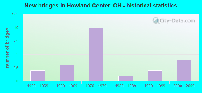
- New bridges - historical statistics
- 21950-1959
- 31960-1969
- 101970-1979
- 11980-1989
- 21990-1999
- 42000-2009

- Reconstructed bridges - Historical Statistics
- 11980-1989
- 21990-1999
- 32000-2009
- 12010-2019


- Bridge Condition - Deck
- 25.0%Excellent
- 37.5%Very good
- 6.3%Good
- 18.8%Satisfactory
- 12.5%Fair

- Bridge Condition - Superstructure
- 31.3%Excellent
- 25.0%Very good
- 31.3%Good
- 6.3%Satisfactory
- 6.3%Fair

- Bridge Condition - Substructure
- 6.3%Excellent
- 18.8%Very good
- 56.3%Good
- 18.8%Satisfactory

- Bridge Condition - Channel
- 15.4%Excellent
- 46.2%Very good
- 23.1%Good
- 7.7%Satisfactory
- 7.7%Fair
Find on map >> Show street view
Structure Number: 7801866, Location: JCT OF SR 11 AND SR 82 (Lat: 41.228489, Lng: -80.709311), Route carried "on" structure: State highway 11, Year Built: 1970, Year Reconstructed: 2010, Status: Open, Structure Length: 10.05m (32.97ft), Average Daily Traffic: 14,251 (year 2015), Truck Traffic: 9%, Average Future Daily Traffic: 19,780 (year 2035), Design Load: HS 20+Mod, Features Intersected: OVER TRU-SR 82-19.74
Minimum Vertical Clearance: 30+ m (98+ ft), Kilometerpoint: 15.385, Lanes on structure: 3, Lanes under structure: 6, Base Highway Network: Yes, Owner: State Highway Agency, Approaching Roadway Width: 16.2m (53.1ft), Skew: 2 degrees, Material/Design: Steel continuous, Design/Construction: Stringer/Multi-beam, Number Of Spans In Main Unit: 4, Length of Maximum Span: 30.2m (99.1ft), Curb-To-Curb Width: 17.2m (56.4ft), Out-to-Out Width: 18.1m (59.4ft)
Condition: Deck: Very good, Superstructure: Good, Substructure: Good, Operating Rating: 42.1 metric tons, Method Used To Determine Operating Rating: Allowable Stress (AS) rating reported by rating factor (RF) method using MS18 loading, Inventory Rating: 32.4 metric tons, Method Used To Determine Inventory Rating: Allowable Stress (AS) rating reported by rating factor (RF) method using MS18 loading, Structural Evaluation: Better than present minimum criteria, Deck Geometry: Better than present minimum criteria, Underclear: Meets minimum limits, Approach Roadway Alignment: Superior to present desirable criteria, Designated Inspection Frequency: Every 24 months, Inspection Date: December 2021, Deck Structure Type: Concrete Cast-file-Place, Wearing Surface/Protective System: Wearing Surface: Monolithic Concrete, Deck Protection: Epoxy Coated Reinforcing
Find on map >> Show street view
Structure Number: 7802595, Location: 2.49 MI N OF SR 82 (Lat: 41.267139, Lng: -80.740961), Route carried "on" structure: State highway 46, Year Built: 2003, Status: Open, Structure Length: 1.87m (6.14ft), Average Daily Traffic: 7,497 (year 2015), Truck Traffic: 2%, Average Future Daily Traffic: 10,406 (year 2035), Design Load: HS 25 or greater, Features Intersected: SPRING RUN
Minimum Vertical Clearance: 30+ m (98+ ft), Kilometerpoint: 15.916, Lanes on structure: 2, Owner: State Highway Agency, Approaching Roadway Width: 13.4m (44.0ft), Skew: 2 degrees, Material/Design: Prestressed concrete, Design/Construction: Box Beam or Girders - Multiple, Number Of Spans In Main Unit: 1, Length of Maximum Span: 18.3m (60.0ft), Curb-To-Curb Width: 13.3m (43.6ft), Out-to-Out Width: 13.4m (44.0ft)
Condition: Deck: Good, Superstructure: Good, Substructure: Good, Channel: Very good, Operating Rating: 42.1 metric tons, Method Used To Determine Operating Rating: Load Factor (LF) rating reported by rating factor (RF) method using MS18 loading, Inventory Rating: 32.4 metric tons, Method Used To Determine Inventory Rating: Load Factor (LF) rating reported by rating factor (RF) method using MS18 loading, Structural Evaluation: Better than present minimum criteria, Deck Geometry: Somewhat better than minimum adequacy, Waterway Adequacy: Equal to present desirable criteria, Approach Roadway Alignment: Superior to present desirable criteria, Designated Inspection Frequency: Every 24 months, Inspection Date: April 2021, Deck Structure Type: Concrete Cast-file-Place, Wearing Surface/Protective System: Wearing Surface: Integral Concrete, Membrane: Epoxy, Deck Protection: Epoxy Coated Reinforcing
Find on map >> Show street view
Structure Number: 7802625, Location: 1.57 MI S OF SR 305 (Lat: 41.286161, Lng: -80.736589), Route carried "on" structure: State highway 46, Year Built: 1978, Status: Open, Structure Length: 0.91m (2.99ft), Average Daily Traffic: 5,790 (year 2015), Truck Traffic: 2%, Average Future Daily Traffic: 8,037 (year 2035), Design Load: HS 20+Mod, Features Intersected: BIG RUN
Minimum Vertical Clearance: 30+ m (98+ ft), Kilometerpoint: 18.089, Lanes on structure: 2, Owner: State Highway Agency, Approaching Roadway Width: 5.5m (18.0ft), Skew: 1 degrees, Material/Design: Prestressed concrete, Design/Construction: Box Beam or Girders - Multiple, Number Of Spans In Main Unit: 1, Length of Maximum Span: 7.9m (25.9ft), Curb-To-Curb Width: 12.2m (40.0ft), Out-to-Out Width: 12.8m (42.0ft)
Condition: Deck: Fair, Superstructure: Fair, Substructure: Good, Channel: Good, Operating Rating: 42.1 metric tons, Method Used To Determine Operating Rating: Load Factor (LF) rating reported by rating factor (RF) method using MS18 loading, Inventory Rating: 32.4 metric tons, Method Used To Determine Inventory Rating: Load Factor (LF) rating reported by rating factor (RF) method using MS18 loading, Structural Evaluation: Somewhat better than minimum adequacy, Deck Geometry: Somewhat better than minimum adequacy, Waterway Adequacy: Equal to present minimum criteria, Approach Roadway Alignment: Equal to present minimum criteria, Designated Inspection Frequency: Every 12 months, Other Special Inspection Frequency: Every 6 months, Inspection Date: April 2021, Other Special Inspection Date: May 2021, Deck Structure Type: Concrete Cast-file-Place, Wearing Surface/Protective System: Wearing Surface: Bituminous, Membrane: Built-up
Find on map >> Show street view
Structure Number: 7804652, Location: 1.68 MI W OF SR11 (Lat: 41.230069, Lng: -80.740869), Route carried "on" structure: State highway 82, Year Built: 1957, Status: Open, Structure Length: 6.16m (20.21ft), Average Daily Traffic: 28,500 (year 2015), Truck Traffic: 14%, Average Future Daily Traffic: 39,558 (year 2035), Design Load: HS 20+Mod, Features Intersected: OVER TRU-SR 46-0731
Minimum Vertical Clearance: 30+ m (98+ ft), Kilometerpoint: 29.049, Lanes on structure: 4, Lanes under structure: 4, Base Highway Network: Yes, Owner: State Highway Agency, Approaching Roadway Width: 15.9m (52.2ft), Skew: 30 degrees, Material/Design: Concrete continuous, Design/Construction: Slab, Number Of Spans In Main Unit: 4, Length of Maximum Span: 15.9m (52.2ft), Curb-To-Curb Width: 17.9m (58.7ft), Out-to-Out Width: 18.9m (62.0ft)
Condition: Deck: Satisfactory, Superstructure: Satisfactory, Substructure: Satisfactory, Operating Rating: 42.1 metric tons, Method Used To Determine Operating Rating: Allowable Stress (AS) rating reported by rating factor (RF) method using MS18 loading, Inventory Rating: 32.4 metric tons, Method Used To Determine Inventory Rating: Allowable Stress (AS) rating reported by rating factor (RF) method using MS18 loading, Structural Evaluation: Equal to present minimum criteria, Deck Geometry: Meets minimum limits, Underclear: High priority of corrective action, Approach Roadway Alignment: Equal to present desirable criteria, Designated Inspection Frequency: Every 12 months, Inspection Date: December 2021, Deck Structure Type: Concrete Cast-file-Place, Wearing Surface/Protective System: Wearing Surface: Integral Concrete
Find on map >> Show street view
Structure Number: 7804687, Location: 0.21 MI W OF SR11 (Lat: 41.227450, Lng: -80.713139), Route carried "on" structure: State highway 82, Year Built: 1970, Year Reconstructed: 2011, Status: Open, Structure Length: 5.15m (16.90ft), Average Daily Traffic: 14,162 (year 2015), Truck Traffic: 14%, Average Future Daily Traffic: 19,657 (year 2035), Design Load: HS 20, Features Intersected: OVER SR11NB TO SR82WB RM
Minimum Vertical Clearance: 30+ m (98+ ft), Kilometerpoint: 31.414, Lanes on structure: 2, Lanes under structure: 2, Base Highway Network: Yes, Owner: State Highway Agency, Approaching Roadway Width: 12.2m (40.0ft), Skew: 4 degrees, Material/Design: Steel continuous, Design/Construction: Stringer/Multi-beam, Number Of Spans In Main Unit: 3, Length of Maximum Span: 20.4m (66.9ft), Curb-To-Curb Width: 13.4m (44.0ft), Out-to-Out Width: 14.3m (46.9ft)
Condition: Deck: Excellent, Superstructure: Excellent, Substructure: Very good, Operating Rating: 42.1 metric tons, Method Used To Determine Operating Rating: Allowable Stress (AS) rating reported by rating factor (RF) method using MS18 loading, Inventory Rating: 32.4 metric tons, Method Used To Determine Inventory Rating: Allowable Stress (AS) rating reported by rating factor (RF) method using MS18 loading, Structural Evaluation: Equal to present desirable criteria, Deck Geometry: Superior to present desirable criteria, Underclear: Superior to present desirable criteria, Approach Roadway Alignment: Superior to present desirable criteria, Designated Inspection Frequency: Every 24 months, Inspection Date: December 2021, Deck Structure Type: Concrete Cast-file-Place, Wearing Surface/Protective System: Wearing Surface: Monolithic Concrete, Deck Protection: Epoxy Coated Reinforcing
Find on map >> Show street view
Structure Number: 7804709, Location: 0.90 MI W OF SR 46 (Lat: 41.236339, Lng: -80.756119), Route carried "on" structure: Ramp State highway 82, Year Built: 2005, Status: Open, Structure Length: 4.67m (15.32ft), Average Daily Traffic: 15,570 (year 2004), Average Future Daily Traffic: 21,611 (year 2024), Design Load: HS 25 or greater, Features Intersected: MOSQUITO CR ACCESSTO SR8
Minimum Vertical Clearance: 30+ m (98+ ft), Kilometerpoint: 27.616, Lanes on structure: 4, Owner: State Highway Agency, Approaching Roadway Width: 7.3m (24.0ft), Skew: 33 degrees, Material/Design: Steel continuous, Design/Construction: Stringer/Multi-beam, Number Of Spans In Main Unit: 3, Length of Maximum Span: 18.3m (60.0ft), Curb-To-Curb Width: 19.5m (64.0ft), Out-to-Out Width: 22.3m (73.2ft)
Condition: Deck: Very good, Superstructure: Good, Substructure: Very good, Channel: Very good, Operating Rating: 42.1 metric tons, Method Used To Determine Operating Rating: Load Factor (LF) rating reported by rating factor (RF) method using MS18 loading, Inventory Rating: 32.4 metric tons, Method Used To Determine Inventory Rating: Load Factor (LF) rating reported by rating factor (RF) method using MS18 loading, Structural Evaluation: Better than present minimum criteria, Deck Geometry: Superior to present desirable criteria, Waterway Adequacy: Superior to present desirable criteria, Approach Roadway Alignment: Equal to present desirable criteria, Designated Inspection Frequency: Every 24 months, Inspection Date: December 2021, Deck Structure Type: Concrete Cast-file-Place, Wearing Surface/Protective System: Wearing Surface: Monolithic Concrete, Deck Protection: Epoxy Coated Reinforcing
Find on map >> Show street view
Structure Number: 7804717, Location: 0.77 MI W OF SR 46 (Lat: 41.234769, Lng: -80.755250), Route carried "on" structure: State highway 82, Year Built: 1979, Status: Open, Structure Length: 3.63m (11.91ft), Average Daily Traffic: 20,824 (year 2015), Truck Traffic: 13%, Average Future Daily Traffic: 28,904 (year 2035), Design Load: HS 20, Features Intersected: EB RAMP OVER MOSQUITO CR
Minimum Vertical Clearance: 30+ m (98+ ft), Kilometerpoint: 27.681, Lanes on structure: 2, Base Highway Network: Yes, Owner: State Highway Agency, Approaching Roadway Width: 11.0m (36.1ft), Skew: 3 degrees, Material/Design: Steel continuous, Design/Construction: Stringer/Multi-beam, Number Of Spans In Main Unit: 3, Length of Maximum Span: 13.7m (44.9ft), Curb-To-Curb Width: 13.1m (43.0ft), Out-to-Out Width: 19.2m (63.0ft)
Condition: Deck: Satisfactory, Superstructure: Good, Substructure: Good, Channel: Very good, Operating Rating: 42.1 metric tons, Method Used To Determine Operating Rating: Allowable Stress (AS) rating reported by rating factor (RF) method using MS18 loading, Inventory Rating: 32.4 metric tons, Method Used To Determine Inventory Rating: Allowable Stress (AS) rating reported by rating factor (RF) method using MS18 loading, Structural Evaluation: Better than present minimum criteria, Deck Geometry: Superior to present desirable criteria, Waterway Adequacy: Superior to present desirable criteria, Approach Roadway Alignment: Superior to present desirable criteria, Designated Inspection Frequency: Every 12 months, Inspection Date: December 2021, Deck Structure Type: Concrete Cast-file-Place, Wearing Surface/Protective System: Wearing Surface: Integral Concrete, Deck Protection: Epoxy Coated Reinforcing
Find on map >> Show street view
Structure Number: 7808054, Location: 0.58 MI N OF SR 82 (Lat: 41.237319, Lng: -80.710211), Route carried "on" structure: County highway C0329, Year Built: 1975, Status: Open, Structure Length: 6.68m (21.92ft), Average Daily Traffic: 1,994 (year 2015), Truck Traffic: 5%, Average Future Daily Traffic: 21,053 (year 2038), Design Load: HS 20, Features Intersected: OVER SR 11, Facility Carried by Structure: WARREN-SHARON ROAD
Minimum Vertical Clearance: 30+ m (98+ ft), Kilometerpoint: 9.849, Lanes on structure: 2, Lanes under structure: 4, Owner: State Highway Agency, Approaching Roadway Width: 12.2m (40.0ft), Skew: 1 degrees, Material/Design: Steel continuous, Design/Construction: Stringer/Multi-beam, Number Of Spans In Main Unit: 2, Length of Maximum Span: 32.6m (107.0ft), Curb or Sidewalk Widths: Left: 30.5m (100.1ft), Right: 30.5m (100.1ft), Curb-To-Curb Width: 11.6m (38.1ft), Out-to-Out Width: 12.8m (42.0ft)
Condition: Deck: Fair, Superstructure: Good, Substructure: Good, Operating Rating: 42.1 metric tons, Method Used To Determine Operating Rating: Load Factor (LF) rating reported by rating factor (RF) method using MS18 loading, Inventory Rating: 32.4 metric tons, Method Used To Determine Inventory Rating: Load Factor (LF) rating reported by rating factor (RF) method using MS18 loading, Structural Evaluation: Better than present minimum criteria, Deck Geometry: Equal to present minimum criteria, Underclear: High priority of corrective action, Approach Roadway Alignment: Equal to present desirable criteria, Designated Inspection Frequency: Every 12 months, Inspection Date: December 2021, Deck Structure Type: Concrete Cast-file-Place, Wearing Surface/Protective System: Wearing Surface: Integral Concrete
Find on map >> Show street view
Structure Number: 7808089, Location: 2.72 MI S OF SR 305 (Lat: 41.271519, Lng: -80.704211), Route carried "on" structure: County highway C0158, Year Built: 2000, Status: Open, Structure Length: 8.05m (26.41ft), Average Daily Traffic: 6,204 (year 2015), Truck Traffic: 11%, Average Future Daily Traffic: 17,288 (year 2035), Design Load: HS 20+Mod, Features Intersected: SR 11 & Spring Run, Facility Carried by Structure: CR15B
Minimum Vertical Clearance: 30+ m (98+ ft), Kilometerpoint: 3.283, Lanes on structure: 4, Lanes under structure: 4, Owner: State Highway Agency, Approaching Roadway Width: 19.2m (63.0ft), Skew: 2 degrees, Material/Design: Steel continuous, Design/Construction: Stringer/Multi-beam, Number Of Spans In Main Unit: 4, Length of Maximum Span: 23.1m (75.8ft), Curb-To-Curb Width: 20.4m (66.9ft), Out-to-Out Width: 21.3m (69.9ft)
Condition: Deck: Satisfactory, Superstructure: Very good, Substructure: Good, Channel: Very good, Operating Rating: 42.1 metric tons, Method Used To Determine Operating Rating: Load Factor (LF) rating reported by rating factor (RF) method using MS18 loading, Inventory Rating: 32.4 metric tons, Method Used To Determine Inventory Rating: Load Factor (LF) rating reported by rating factor (RF) method using MS18 loading, Structural Evaluation: Better than present minimum criteria, Deck Geometry: Superior to present desirable criteria, Underclear: Meets minimum limits, Waterway Adequacy: Superior to present desirable criteria, Approach Roadway Alignment: Better than present minimum criteria, Designated Inspection Frequency: Every 12 months, Inspection Date: June 2021, Deck Structure Type: Concrete Cast-file-Place, Wearing Surface/Protective System: Wearing Surface: Monolithic Concrete, Membrane: Epoxy
Find on map >> Show street view
Structure Number: 7808097, Location: 2.73 MI S OF SR 305 (Lat: 41.271789, Lng: -80.704589), Route carried "on" structure: State highway 11, Year Built: 1970, Year Reconstructed: 2002, Status: Open, Structure Length: 0.70m (2.30ft), Average Daily Traffic: 6,228 (year 2015), Truck Traffic: 11%, Average Future Daily Traffic: 8,644 (year 2035), Design Load: HS 20+Mod, Features Intersected: SPRING RUN
Minimum Vertical Clearance: 5.33m (17.49ft), Kilometerpoint: 20.278, Lanes on structure: 2, Base Highway Network: Yes, Owner: State Highway Agency, Approaching Roadway Width: 10.9m (35.8ft), Skew: 3 degrees, Material/Design: Concrete, Design/Construction: Slab, Number Of Spans In Main Unit: 1, Length of Maximum Span: 6.1m (20.0ft), Curb-To-Curb Width: 16.2m (53.1ft), Out-to-Out Width: 17.4m (57.1ft)
Condition: Deck: Very good, Superstructure: Very good, Substructure: Good, Channel: Very good, Operating Rating: 42.1 metric tons, Method Used To Determine Operating Rating: Load Factor (LF) rating reported by rating factor (RF) method using MS18 loading, Inventory Rating: 32.4 metric tons, Method Used To Determine Inventory Rating: Load Factor (LF) rating reported by rating factor (RF) method using MS18 loading, Structural Evaluation: Better than present minimum criteria, Deck Geometry: Superior to present desirable criteria, Waterway Adequacy: Equal to present desirable criteria, Approach Roadway Alignment: Equal to present desirable criteria, Designated Inspection Frequency: Every 24 months, Inspection Date: April 2021, Deck Structure Type: Concrete Cast-file-Place, Wearing Surface/Protective System: Wearing Surface: Monolithic Concrete, Membrane: Preformed Fabric
Find on map >> Show street view
Structure Number: 78081, Location: 2.73 MI S OF SR 305 (Lat: 41.271550, Lng: -80.704169), Route carried "on" structure: State highway 11, Year Built: 1970, Year Reconstructed: 2002, Status: Open, Structure Length: 0.70m (2.30ft), Average Daily Traffic: 6,228 (year 2015), Truck Traffic: 11%, Average Future Daily Traffic: 8,644 (year 2035), Design Load: HS 20+Mod, Features Intersected: SPRING RUN
Minimum Vertical Clearance: 5.46m (17.91ft), Kilometerpoint: 20.278, Lanes on structure: 2, Base Highway Network: Yes, Owner: State Highway Agency, Approaching Roadway Width: 10.9m (35.8ft), Skew: 3 degrees, Material/Design: Concrete, Design/Construction: Slab, Number Of Spans In Main Unit: 1, Length of Maximum Span: 6.1m (20.0ft), Curb-To-Curb Width: 12.2m (40.0ft), Out-to-Out Width: 13.2m (43.3ft)
Condition: Deck: Very good, Superstructure: Very good, Substructure: Good, Channel: Very good, Operating Rating: 42.1 metric tons, Method Used To Determine Operating Rating: Load Factor (LF) rating reported by rating factor (RF) method using MS18 loading, Inventory Rating: 32.4 metric tons, Method Used To Determine Inventory Rating: Load Factor (LF) rating reported by rating factor (RF) method using MS18 loading, Structural Evaluation: Better than present minimum criteria, Deck Geometry: Somewhat better than minimum adequacy, Waterway Adequacy: Equal to present desirable criteria, Approach Roadway Alignment: Equal to present desirable criteria, Designated Inspection Frequency: Every 24 months, Inspection Date: April 2021, Deck Structure Type: Concrete Cast-file-Place, Wearing Surface/Protective System: Wearing Surface: Monolithic Concrete, Membrane: Built-up, Deck Protection: Epoxy Coated Reinforcing
Find on map >> Show street view
Structure Number: 7838417, Location: 0.4 MILE E. OF C.H. 54 (Lat: 41.265539, Lng: -80.766931), Route carried "on" structure: County highway C142D, Year Built: 1999, Status: Open, Structure Length: 1.95m (6.40ft), Average Daily Traffic: 7,842 (year 2015), Truck Traffic: 4%, Average Future Daily Traffic: 10,885 (year 2035), Design Load: HS 20+Mod, Features Intersected: MOSQUITO CREEK, Facility Carried by Structure: NORTH RIVER ROAD
Minimum Vertical Clearance: 30+ m (98+ ft), Kilometerpoint: 0.129, Lanes on structure: 2, Owner: County Highway Agency, Approaching Roadway Width: 7.9m (25.9ft), Skew: 2 degrees, Material/Design: Prestressed concrete, Design/Construction: Box Beam or Girders - Multiple, Number Of Spans In Main Unit: 1, Length of Maximum Span: 19.2m (63.0ft), Curb-To-Curb Width: 12.2m (40.0ft), Out-to-Out Width: 12.2m (40.0ft)
Condition: Deck: Excellent, Superstructure: Excellent, Substructure: Excellent, Channel: Good, Operating Rating: 68.0 metric tons, Method Used To Determine Operating Rating: Load Factor (LF) rating reported by rating factor (RF) method using MS18 loading, Inventory Rating: 42.1 metric tons, Method Used To Determine Inventory Rating: Load Factor (LF) rating reported by rating factor (RF) method using MS18 loading, Structural Evaluation: Superior to present desirable criteria, Deck Geometry: Somewhat better than minimum adequacy, Waterway Adequacy: Superior to present desirable criteria, Approach Roadway Alignment: Equal to present minimum criteria, Designated Inspection Frequency: Every 24 months, Inspection Date: April 2021, Deck Structure Type: Concrete Cast-file-Place, Wearing Surface/Protective System: Wearing Surface: Bituminous, Membrane: Preformed Fabric
Find on map >> Show street view
Structure Number: 7838611, Location: 0.55 MILE E. OF C.H. 54 (Lat: 41.265539, Lng: -80.764261), Route carried "on" structure: County highway C142D, Year Built: 1999, Status: Open, Structure Length: 2.87m (9.42ft), Average Daily Traffic: 7,842 (year 2015), Truck Traffic: 4%, Average Future Daily Traffic: 10,885 (year 2035), Design Load: HS 20+Mod, Features Intersected: MOSQUITO CREEK, Facility Carried by Structure: NORTH RIVER ROAD
Minimum Vertical Clearance: 30+ m (98+ ft), Kilometerpoint: 0.145, Lanes on structure: 2, Owner: County Highway Agency, Approaching Roadway Width: 7.9m (25.9ft), Skew: 1 degrees, Material/Design: Prestressed concrete, Design/Construction: Box Beam or Girders - Multiple, Number Of Spans In Main Unit: 3, Length of Maximum Span: 9.1m (29.9ft), Curb-To-Curb Width: 12.2m (40.0ft), Out-to-Out Width: 12.2m (40.0ft)
Condition: Deck: Excellent, Superstructure: Excellent, Substructure: Very good, Channel: Excellent, Operating Rating: 87.5 metric tons, Method Used To Determine Operating Rating: Load Factor (LF) rating reported by rating factor (RF) method using MS18 loading, Inventory Rating: 51.8 metric tons, Method Used To Determine Inventory Rating: Load Factor (LF) rating reported by rating factor (RF) method using MS18 loading, Structural Evaluation: Equal to present desirable criteria, Deck Geometry: Somewhat better than minimum adequacy, Waterway Adequacy: Superior to present desirable criteria, Approach Roadway Alignment: Equal to present minimum criteria, Designated Inspection Frequency: Every 24 months, Inspection Date: April 2021, Deck Structure Type: Concrete Cast-file-Place, Wearing Surface/Protective System: Wearing Surface: Bituminous, Membrane: Preformed Fabric
Find on map >> Show street view
Structure Number: 784131, Location: 0.2 MI. N. OF C.H. 158 (Lat: 41.271981, Lng: -80.711761), Route carried "on" structure: County highway T157A, Year Built: 1966, Year Reconstructed: 2013, Status: Open, Structure Length: 0.88m (2.89ft), Average Daily Traffic: 951 (year 2015), Truck Traffic: 5%, Average Future Daily Traffic: 1,320 (year 2035), Design Load: HL 93, Features Intersected: STREAM, Facility Carried by Structure: TOWNSHIP RD. 157-A
Minimum Vertical Clearance: 30+ m (98+ ft), Kilometerpoint: 0.193, Lanes on structure: 2, Owner: County Highway Agency, Approaching Roadway Width: 6.1m (20.0ft), Material/Design: Steel, Design/Construction: Stringer/Multi-beam, Number Of Spans In Main Unit: 1, Length of Maximum Span: 8.2m (26.9ft), Curb-To-Curb Width: 7.3m (24.0ft), Out-to-Out Width: 7.3m (24.0ft)
Condition: Deck: Very good, Superstructure: Excellent, Substructure: Good, Channel: Good, Operating Rating: 55.1 metric tons, Method Used To Determine Operating Rating: Load and Resistance Factor Rating (LRFR) rating reported by rating factor(RF) method using HL-93 loadings, Inventory Rating: 42.1 metric tons, Method Used To Determine Inventory Rating: Load and Resistance Factor Rating (LRFR) rating reported by rating factor(RF) method using HL-93 loadings, Structural Evaluation: Better than present minimum criteria, Deck Geometry: Meets minimum limits, Waterway Adequacy: Better than present minimum criteria, Approach Roadway Alignment: Better than present minimum criteria, Designated Inspection Frequency: Every 24 months, Inspection Date: April 2021, Deck Structure Type: Corrugated Steel, Wearing Surface/Protective System: Wearing Surface: Bituminous
Find on map >> Show street view
Structure Number: 7841361, Location: 0.3 MI. N. OF C.H. 158 (Lat: 41.268189, Lng: -80.724939), Route carried "on" structure: County highway T155E, Year Built: 1962, Year Reconstructed: 2013, Status: Open, Structure Length: 0.85m (2.79ft), Average Daily Traffic: 983 (year 2015), Truck Traffic: 5%, Average Future Daily Traffic: 1,364 (year 2035), Design Load: HL 93, Features Intersected: SPRING RUN, Facility Carried by Structure: TOWNSHIP RD. 155-E
Minimum Vertical Clearance: 30+ m (98+ ft), Kilometerpoint: 0.016, Lanes on structure: 2, Owner: County Highway Agency, Approaching Roadway Width: 8.5m (27.9ft), Material/Design: Steel, Design/Construction: Stringer/Multi-beam, Number Of Spans In Main Unit: 1, Length of Maximum Span: 8.2m (26.9ft), Curb-To-Curb Width: 7.9m (25.9ft), Out-to-Out Width: 7.9m (25.9ft)
Condition: Deck: Excellent, Superstructure: Excellent, Substructure: Satisfactory, Channel: Satisfactory, Operating Rating: 71.3 metric tons, Method Used To Determine Operating Rating: Load and Resistance Factor Rating (LRFR) rating reported by rating factor(RF) method using HL-93 loadings, Inventory Rating: 55.1 metric tons, Method Used To Determine Inventory Rating: Load and Resistance Factor Rating (LRFR) rating reported by rating factor(RF) method using HL-93 loadings, Structural Evaluation: Equal to present minimum criteria, Deck Geometry: Somewhat better than minimum adequacy, Waterway Adequacy: Equal to present desirable criteria, Approach Roadway Alignment: Better than present minimum criteria, Designated Inspection Frequency: Every 12 months, Inspection Date: April 2021, Deck Structure Type: Corrugated Steel, Wearing Surface/Protective System: Wearing Surface: Bituminous
Find on map >> Show street view
Structure Number: 7842279, Location: 0.1 MI. N. T.H. 196A (Lat: 41.285000, Lng: -80.738331), Route carried "on" structure: County highway T201B, Year Built: 1964, Year Reconstructed: 1992, Status: Open, Structure Length: 1.10m (3.61ft), Average Daily Traffic: 1,000 (year 2015), Truck Traffic: 5%, Average Future Daily Traffic: 1,388 (year 2035), Design Load: H 20, Features Intersected: BIG RUN, Facility Carried by Structure: TOWNSHIP ROAD 201B
Minimum Vertical Clearance: 30+ m (98+ ft), Kilometerpoint: 0.145, Lanes on structure: 2, Owner: County Highway Agency, Approaching Roadway Width: 7.3m (24.0ft), Material/Design: Steel, Design/Construction: Stringer/Multi-beam, Number Of Spans In Main Unit: 1, Length of Maximum Span: 10.1m (33.1ft), Curb-To-Curb Width: 7.3m (24.0ft), Out-to-Out Width: 7.8m (25.6ft)
Condition: Deck: Very good, Superstructure: Very good, Substructure: Satisfactory, Channel: Fair, Operating Rating: 61.6 metric tons, Method Used To Determine Operating Rating: Load Factor (LF) rating reported by rating factor (RF) method using MS18 loading, Inventory Rating: 35.6 metric tons, Method Used To Determine Inventory Rating: Load Factor (LF) rating reported by rating factor (RF) method using MS18 loading, Structural Evaluation: Equal to present minimum criteria, Deck Geometry: Meets minimum limits, Waterway Adequacy: Better than present minimum criteria, Approach Roadway Alignment: Better than present minimum criteria, Length Of Structure Improvement: 1.07m (3.51ft), Designated Inspection Frequency: Every 12 months, Inspection Date: April 2021, Bridge Improvement Cost: $185,000, Roadway Improvement Cost: $15,000, Total Project Cost: $200,000, Deck Structure Type: Corrugated Steel, Wearing Surface/Protective System: Wearing Surface: Bituminous
Find on map >> Show street view
Structure Number: 784842, Location: 186 F. S. OF TH1368 (Lat: 41.233331, Lng: -80.735000), Route carried "on" structure: County highway T0844, Year Built: 1987, Status: Open, Structure Length: 0.76m (2.49ft), Average Daily Traffic: 1,949 (year 2015), Truck Traffic: 5%, Average Future Daily Traffic: 2,705 (year 2035), Design Load: H 20, Features Intersected: STREAM - FLOW W., Facility Carried by Structure: TOWNSHIP ROAD 844
Minimum Vertical Clearance: 30+ m (98+ ft), Kilometerpoint: 0.274, Lanes on structure: 2, Owner: County Highway Agency, Approaching Roadway Width: 9.1m (29.9ft), Skew: 1 degrees, Material/Design: Steel, Design/Construction: Culvert, Number Of Spans In Main Unit: 1, Length of Maximum Span: 7.6m (24.9ft)
Condition: Channel: Excellent, Culverts: Good, Operating Rating: 97.2 metric tons, Method Used To Determine Operating Rating: Load Factor (LF) rating reported by rating factor (RF) method using MS18 loading, Inventory Rating: 68.0 metric tons, Method Used To Determine Inventory Rating: Load Factor (LF) rating reported by rating factor (RF) method using MS18 loading, Structural Evaluation: Better than present minimum criteria, Waterway Adequacy: Superior to present desirable criteria, Approach Roadway Alignment: Equal to present desirable criteria, Designated Inspection Frequency: Every 24 months, Inspection Date: April 2021
Find on map >> Show street view
Structure Number: 7801866, Location: JCT OF SR 11 AND SR 82 (Lat: 41.228489, Lng: -80.709311), Route carried "under" structure: State highway 82, Year Built: 1970, Structure Length: 0. m, Average Daily Traffic: 28,323 (year 2015), Truck Traffic: 14%, Features Intersected: SR 11, Facility Carried by Structure: SR 11
Minimum Vertical Clearance: 5.17m (16.96ft), Kilometerpoint: 31.768, Lanes on structure: 3, Lanes under structure: 6, Material/Design: Steel continuous, Design/Construction: Stringer/Multi-beam, Length of Maximum Span: 30.2m (99.1ft)
Find on map >> Show street view
Structure Number: 7804652, Location: 1.68 MI W OF SR11 (Lat: 41.230069, Lng: -80.740869), Route carried "under" structure: State highway 46, Year Built: 1957, Structure Length: 0. m, Average Daily Traffic: 21,124 (year 2015), Truck Traffic: 8%, Features Intersected: SR 82, Facility Carried by Structure: SR 82
Minimum Vertical Clearance: 5.05m (16.57ft), Kilometerpoint: 11.764, Lanes on structure: 4, Lanes under structure: 4, Material/Design: Concrete continuous, Design/Construction: Slab, Length of Maximum Span: 15.9m (52.2ft)
Find on map >> Show street view
Structure Number: 7804687, Location: 0.21 MI W OF SR11 (Lat: 41.227450, Lng: -80.713139), Route carried "under" structure: Ramp State highway 11, Year Built: 1970, Structure Length: 0. m, Average Daily Traffic: 38,120 (year 2011), Truck Traffic: 10%, Features Intersected: SR11 NB RAMP TO SR82 WB, Facility Carried by Structure: SR 82
Minimum Vertical Clearance: 5.21m (17.09ft), Kilometerpoint: 15.257, Lanes on structure: 2, Lanes under structure: 2, Material/Design: Steel continuous, Design/Construction: Stringer/Multi-beam, Length of Maximum Span: 20.4m (66.9ft)
Find on map >> Show street view
Structure Number: 7808054, Location: 0.58 MI N OF SR 82 (Lat: 41.237319, Lng: -80.710211), Route carried "under" structure: State highway 11, Year Built: 1975, Structure Length: 0. m, Average Daily Traffic: 15,168 (year 2015), Truck Traffic: 10%, Features Intersected: UNDER WARREN-SHARON CR32, Facility Carried by Structure: WARREN-SHARON ROAD
Minimum Vertical Clearance: 5.16m (16.93ft), Kilometerpoint: 16.383, Lanes on structure: 2, Lanes under structure: 4, Material/Design: Steel continuous, Design/Construction: Stringer/Multi-beam, Length of Maximum Span: 32.6m (107.0ft)
Find on map >> Show street view
Structure Number: 7808089, Location: 2.72 MI S OF SR 305 (Lat: 41.271519, Lng: -80.704211), Route carried "under" structure: State highway 11, Year Built: 2000, Structure Length: 0. m, Average Daily Traffic: 12,455 (year 2015), Truck Traffic: 11%, Features Intersected: OVER S.R.11 & Spring Run, Facility Carried by Structure: CR15B
Minimum Vertical Clearance: 5.31m (17.42ft), Kilometerpoint: 20.278, Lanes on structure: 4, Lanes under structure: 4, Material/Design: Steel continuous, Design/Construction: Stringer/Multi-beam, Length of Maximum Span: 23.1m (75.8ft)