Bridge Statistics for Horizon West, Florida (FL)
Condition, Traffic, Stress, Structural Evaluation, Project Costs
- National Bridge Inventory (NBI) Statistics
- 40Number of bridges
- 358ft / 109mTotal length
- 898,801Total average daily traffic
- 37,304Total average daily truck traffic
- National Bridge Inventory (NBI) Registered Bridges for Horizon West
- No street view available for this location
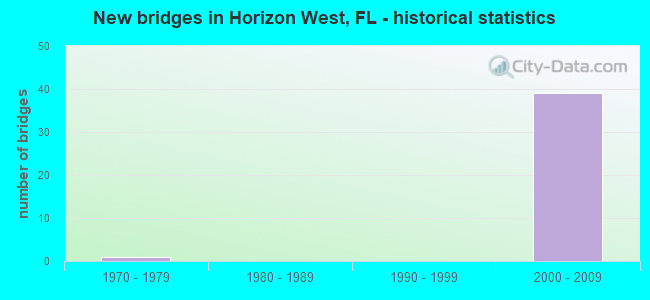
- New bridges - historical statistics
- 11970-1979
- 392000-2009


- Bridge Condition - Deck
- 80.0%Very good
- 20.0%Good

- Bridge Condition - Superstructure
- 75.0%Very good
- 25.0%Good

- Bridge Condition - Substructure
- 75.0%Very good
- 25.0%Good

- Bridge Condition - Channel
- 33.3%Very good
- 66.7%Good
Find on map >> Show street view
Structure Number: 75052, Location: 2.7Mi S of New Indep Pkwy (Lat: 28.437903, Lng: -81.638569), Route carried "on" structure: State highway 429, Year Built: 2005, Status: Open, Structure Length: 4.34m (14.24ft), Average Daily Traffic: 47,000 (year 2020), Truck Traffic: 3%, Average Future Daily Traffic: 81,545 (year 2042), Design Load: HS 20+Mod, Features Intersected: Old YMCA Rd.
Minimum Vertical Clearance: 30+ m (98+ ft), Kilometerpoint: 31.062, Lanes on structure: 2, Lanes under structure: 2, Base Highway Network: Yes, Toll: On toll road, Owner: State Toll Authority, Approaching Roadway Width: 12.2m (40.0ft), Skew: 3 degrees, Material/Design: Prestressed concrete, Design/Construction: Stringer/Multi-beam, Number Of Spans In Main Unit: 1, Length of Maximum Span: 42.8m (140.4ft), Curb-To-Curb Width: 12.2m (40.0ft), Out-to-Out Width: 13.1m (43.0ft)
Condition: Deck: Very good, Superstructure: Very good, Substructure: Very good, Operating Rating: 51.6 metric tons, Method Used To Determine Operating Rating: Load Factor (LF), Inventory Rating: 30.9 metric tons, Method Used To Determine Inventory Rating: Load Factor (LF), Structural Evaluation: Better than present minimum criteria, Deck Geometry: Better than present minimum criteria, Underclear: Superior to present desirable criteria, Approach Roadway Alignment: Equal to present desirable criteria, Designated Inspection Frequency: Every 24 months, Inspection Date: November 2021, Deck Structure Type: Concrete Cast-file-Place
Find on map >> Show street view
Structure Number: 750521, Location: 2.7Mi S of New Indep Pkwy (Lat: 28.437942, Lng: -81.638247), Route carried "on" structure: State highway 429, Year Built: 2005, Status: Open, Structure Length: 4.34m (14.24ft), Average Daily Traffic: 47,000 (year 2020), Truck Traffic: 3%, Average Future Daily Traffic: 81,545 (year 2042), Design Load: HS 20+Mod, Features Intersected: Old YMCA Rd.
Minimum Vertical Clearance: 30+ m (98+ ft), Kilometerpoint: 31.047, Lanes on structure: 2, Lanes under structure: 2, Base Highway Network: Yes, Toll: On toll road, Owner: State Toll Authority, Approaching Roadway Width: 12.2m (40.0ft), Skew: 3 degrees, Material/Design: Prestressed concrete, Design/Construction: Stringer/Multi-beam, Number Of Spans In Main Unit: 1, Length of Maximum Span: 42.8m (140.4ft), Curb-To-Curb Width: 12.2m (40.0ft), Out-to-Out Width: 13.1m (43.0ft)
Condition: Deck: Very good, Superstructure: Very good, Substructure: Very good, Operating Rating: 51.6 metric tons, Method Used To Determine Operating Rating: Load Factor (LF), Inventory Rating: 30.9 metric tons, Method Used To Determine Inventory Rating: Load Factor (LF), Structural Evaluation: Better than present minimum criteria, Deck Geometry: Better than present minimum criteria, Underclear: Superior to present desirable criteria, Approach Roadway Alignment: Equal to present desirable criteria, Designated Inspection Frequency: Every 24 months, Inspection Date: November 2021, Deck Structure Type: Concrete Cast-file-Place
Find on map >> Show street view
Structure Number: 750522, Location: 2.8Mi S of New Indep Pkwy (Lat: 28.436167, Lng: -81.637389), Route carried "on" structure: State highway 429, Year Built: 2005, Status: Open, Structure Length: 7.24m (23.75ft), Average Daily Traffic: 47,000 (year 2020), Truck Traffic: 3%, Average Future Daily Traffic: 81,545 (year 2042), Design Load: HS 20+Mod, Features Intersected: CR-545 South
Minimum Vertical Clearance: 30+ m (98+ ft), Kilometerpoint: 30.819, Lanes on structure: 2, Lanes under structure: 2, Base Highway Network: Yes, Toll: On toll road, Owner: State Toll Authority, Approaching Roadway Width: 12.2m (40.0ft), Skew: 4 degrees, Material/Design: Prestressed concrete, Design/Construction: Stringer/Multi-beam, Number Of Spans In Main Unit: 2, Length of Maximum Span: 36.6m (120.1ft), Curb-To-Curb Width: 12.2m (40.0ft), Out-to-Out Width: 13.1m (43.0ft)
Condition: Deck: Very good, Superstructure: Very good, Substructure: Very good, Operating Rating: 83.0 metric tons, Method Used To Determine Operating Rating: Load Factor (LF), Inventory Rating: 49.8 metric tons, Method Used To Determine Inventory Rating: Load Factor (LF), Structural Evaluation: Equal to present desirable criteria, Deck Geometry: Better than present minimum criteria, Underclear: Superior to present desirable criteria, Approach Roadway Alignment: Equal to present desirable criteria, Designated Inspection Frequency: Every 24 months, Inspection Date: November 2021, Deck Structure Type: Concrete Cast-file-Place
Find on map >> Show street view
Structure Number: 750523, Location: 2.8Mi S of New Indep Pkwy (Lat: 28.436581, Lng: -81.637331), Route carried "on" structure: State highway 429, Year Built: 2005, Status: Open, Structure Length: 7.24m (23.75ft), Average Daily Traffic: 47,000 (year 2020), Truck Traffic: 3%, Average Future Daily Traffic: 81,545 (year 2042), Design Load: HS 20+Mod, Features Intersected: CR-545 South
Minimum Vertical Clearance: 30+ m (98+ ft), Kilometerpoint: 30.854, Lanes on structure: 2, Lanes under structure: 2, Base Highway Network: Yes, Toll: On toll road, Owner: State Toll Authority, Approaching Roadway Width: 12.2m (40.0ft), Skew: 4 degrees, Material/Design: Prestressed concrete, Design/Construction: Stringer/Multi-beam, Number Of Spans In Main Unit: 2, Length of Maximum Span: 36.6m (120.1ft), Curb-To-Curb Width: 12.2m (40.0ft), Out-to-Out Width: 13.1m (43.0ft)
Condition: Deck: Good, Superstructure: Very good, Substructure: Very good, Inventory Rating: 54.1 metric tons, Method Used To Determine Inventory Rating: Load Factor (LF), Structural Evaluation: Equal to present desirable criteria, Deck Geometry: Better than present minimum criteria, Underclear: Superior to present desirable criteria, Approach Roadway Alignment: Equal to present desirable criteria, Designated Inspection Frequency: Every 24 months, Inspection Date: November 2021, Deck Structure Type: Concrete Cast-file-Place
Find on map >> Show street view
Structure Number: 750524, Location: 1.1Mi S of New Indep Pkwy (Lat: 28.458883, Lng: -81.636825), Route carried "on" structure: State highway 429, Year Built: 2005, Status: Open, Structure Length: 6.04m (19.82ft), Average Daily Traffic: 47,000 (year 2020), Truck Traffic: 3%, Average Future Daily Traffic: 81,545 (year 2042), Design Load: HS 20+Mod, Features Intersected: CR-545 North
Minimum Vertical Clearance: 30+ m (98+ ft), Kilometerpoint: 33.603, Lanes on structure: 2, Lanes under structure: 2, Base Highway Network: Yes, Toll: On toll road, Owner: State Toll Authority, Approaching Roadway Width: 12.2m (40.0ft), Skew: 2 degrees, Material/Design: Prestressed concrete, Design/Construction: Stringer/Multi-beam, Number Of Spans In Main Unit: 2, Length of Maximum Span: 36.2m (118.8ft), Curb-To-Curb Width: 12.2m (40.0ft), Out-to-Out Width: 13.1m (43.0ft)
Condition: Deck: Very good, Superstructure: Very good, Substructure: Very good, Operating Rating: 60.8 metric tons, Method Used To Determine Operating Rating: Load Factor (LF), Inventory Rating: 36.5 metric tons, Method Used To Determine Inventory Rating: Load Factor (LF), Structural Evaluation: Equal to present desirable criteria, Deck Geometry: Better than present minimum criteria, Underclear: Superior to present desirable criteria, Approach Roadway Alignment: Equal to present desirable criteria, Designated Inspection Frequency: Every 24 months, Inspection Date: November 2021, Deck Structure Type: Concrete Cast-file-Place
Find on map >> Show street view
Structure Number: 750525, Location: 1.1Mi S of New Indep Pkwy (Lat: 28.458667, Lng: -81.636692), Route carried "on" structure: State highway 429, Year Built: 2005, Status: Open, Structure Length: 6.04m (19.82ft), Average Daily Traffic: 47,000 (year 2020), Truck Traffic: 3%, Average Future Daily Traffic: 81,545 (year 2042), Design Load: HS 20+Mod, Features Intersected: CR-545 North
Minimum Vertical Clearance: 30+ m (98+ ft), Kilometerpoint: 33.603, Lanes on structure: 2, Lanes under structure: 2, Base Highway Network: Yes, Toll: On toll road, Owner: State Toll Authority, Approaching Roadway Width: 12.2m (40.0ft), Skew: 2 degrees, Material/Design: Prestressed concrete, Design/Construction: Stringer/Multi-beam, Number Of Spans In Main Unit: 2, Length of Maximum Span: 35.1m (115.2ft), Curb-To-Curb Width: 12.2m (40.0ft), Out-to-Out Width: 13.1m (43.0ft)
Condition: Deck: Very good, Superstructure: Very good, Substructure: Very good, Operating Rating: 60.8 metric tons, Method Used To Determine Operating Rating: Load Factor (LF), Inventory Rating: 36.5 metric tons, Method Used To Determine Inventory Rating: Load Factor (LF), Structural Evaluation: Equal to present desirable criteria, Deck Geometry: Better than present minimum criteria, Underclear: Superior to present desirable criteria, Approach Roadway Alignment: Equal to present desirable criteria, Designated Inspection Frequency: Every 24 months, Inspection Date: November 2021, Deck Structure Type: Concrete Cast-file-Place
Find on map >> Show street view
Structure Number: 750526, Location: 1Mi S of New Indep Pkwy (Lat: 28.459858, Lng: -81.635864), Route carried "on" structure: State highway 429, Year Built: 2005, Status: Open, Structure Length: 5.44m (17.85ft), Average Daily Traffic: 47,000 (year 2020), Truck Traffic: 3%, Average Future Daily Traffic: 81,545 (year 2042), Design Load: HS 20+Mod, Features Intersected: Porter Road
Minimum Vertical Clearance: 30+ m (98+ ft), Kilometerpoint: 33.753, Lanes on structure: 2, Lanes under structure: 2, Base Highway Network: Yes, Toll: On toll road, Owner: State Toll Authority, Approaching Roadway Width: 12.2m (40.0ft), Skew: 4 degrees, Material/Design: Steel, Design/Construction: Stringer/Multi-beam, Number Of Spans In Main Unit: 1, Length of Maximum Span: 53.8m (176.5ft), Curb-To-Curb Width: 12.2m (40.0ft), Out-to-Out Width: 13.1m (43.0ft)
Condition: Deck: Very good, Superstructure: Very good, Substructure: Very good, Operating Rating: 69.0 metric tons, Method Used To Determine Operating Rating: Load Factor (LF), Inventory Rating: 41.5 metric tons, Method Used To Determine Inventory Rating: Load Factor (LF), Structural Evaluation: Equal to present desirable criteria, Deck Geometry: Better than present minimum criteria, Underclear: Superior to present desirable criteria, Approach Roadway Alignment: Equal to present desirable criteria, Designated Inspection Frequency: Every 24 months, Inspection Date: November 2021, Deck Structure Type: Concrete Cast-file-Place
Find on map >> Show street view
Structure Number: 750527, Location: 1Mi S of New Indep Pkwy (Lat: 28.459869, Lng: -81.635456), Route carried "on" structure: State highway 429, Year Built: 2005, Status: Open, Structure Length: 5.44m (17.85ft), Average Daily Traffic: 47,000 (year 2020), Truck Traffic: 3%, Average Future Daily Traffic: 81,545 (year 2042), Design Load: HS 20+Mod, Features Intersected: Porter Road
Minimum Vertical Clearance: 30.45m (99.90ft), Kilometerpoint: 33.780, Lanes on structure: 2, Lanes under structure: 2, Base Highway Network: Yes, Toll: On toll road, Owner: State Toll Authority, Approaching Roadway Width: 12.2m (40.0ft), Skew: 4 degrees, Material/Design: Steel, Design/Construction: Stringer/Multi-beam, Number Of Spans In Main Unit: 1, Length of Maximum Span: 53.8m (176.5ft), Curb-To-Curb Width: 12.2m (40.0ft), Out-to-Out Width: 13.1m (43.0ft)
Condition: Deck: Very good, Superstructure: Very good, Substructure: Very good, Operating Rating: 69.0 metric tons, Method Used To Determine Operating Rating: Load Factor (LF), Inventory Rating: 41.5 metric tons, Method Used To Determine Inventory Rating: Load Factor (LF), Structural Evaluation: Equal to present desirable criteria, Deck Geometry: Better than present minimum criteria, Underclear: Better than present minimum criteria, Approach Roadway Alignment: Equal to present desirable criteria, Designated Inspection Frequency: Every 24 months, Inspection Date: November 2021, Deck Structure Type: Concrete Cast-file-Place
Find on map >> Show street view
Structure Number: 750528, Location: 1.9Mi S of New Indep Pkwy (Lat: 28.448833, Lng: -81.642689), Route carried "on" structure: State highway 429, Year Built: 2005, Status: Open, Structure Length: 4.10m (13.45ft), Average Daily Traffic: 47,000 (year 2020), Truck Traffic: 3%, Average Future Daily Traffic: 81,545 (year 2042), Design Load: HS 20+Mod, Features Intersected: Schofield Road
Minimum Vertical Clearance: 30+ m (98+ ft), Kilometerpoint: 32.359, Lanes on structure: 2, Lanes under structure: 2, Base Highway Network: Yes, Toll: On toll road, Owner: State Toll Authority, Approaching Roadway Width: 12.2m (40.0ft), Material/Design: Prestressed concrete, Design/Construction: Stringer/Multi-beam, Number Of Spans In Main Unit: 1, Length of Maximum Span: 40.4m (132.5ft), Curb-To-Curb Width: 12.2m (40.0ft), Out-to-Out Width: 13.1m (43.0ft)
Condition: Deck: Very good, Superstructure: Very good, Substructure: Very good, Operating Rating: 84.8 metric tons, Method Used To Determine Operating Rating: Load Factor (LF), Inventory Rating: 50.9 metric tons, Method Used To Determine Inventory Rating: Load Factor (LF), Structural Evaluation: Equal to present desirable criteria, Deck Geometry: Better than present minimum criteria, Underclear: Superior to present desirable criteria, Approach Roadway Alignment: Equal to present desirable criteria, Designated Inspection Frequency: Every 24 months, Inspection Date: November 2021, Deck Structure Type: Concrete Cast-file-Place
Find on map >> Show street view
Structure Number: 750529, Location: 1.9Mi S of New Indep Pkwy (Lat: 28.448850, Lng: -81.642378), Route carried "on" structure: State highway 429, Year Built: 2005, Status: Open, Structure Length: 4.10m (13.45ft), Average Daily Traffic: 47,000 (year 2020), Truck Traffic: 3%, Average Future Daily Traffic: 81,545 (year 2042), Design Load: HS 20+Mod, Features Intersected: Schofield Road
Minimum Vertical Clearance: 30+ m (98+ ft), Kilometerpoint: 32.359, Lanes on structure: 2, Lanes under structure: 2, Base Highway Network: Yes, Toll: On toll road, Owner: State Toll Authority, Approaching Roadway Width: 12.2m (40.0ft), Material/Design: Prestressed concrete, Design/Construction: Stringer/Multi-beam, Number Of Spans In Main Unit: 1, Length of Maximum Span: 40.4m (132.5ft), Curb-To-Curb Width: 15.9m (52.2ft), Out-to-Out Width: 16.8m (55.1ft)
Condition: Deck: Very good, Superstructure: Very good, Substructure: Very good, Operating Rating: 79.5 metric tons, Method Used To Determine Operating Rating: Load Factor (LF), Inventory Rating: 47.7 metric tons, Method Used To Determine Inventory Rating: Load Factor (LF), Structural Evaluation: Equal to present desirable criteria, Deck Geometry: Superior to present desirable criteria, Underclear: Superior to present desirable criteria, Approach Roadway Alignment: Equal to present desirable criteria, Designated Inspection Frequency: Every 24 months, Inspection Date: November 2021, Deck Structure Type: Concrete Cast-file-Place
Find on map >> Show street view
Structure Number: 75053, Location: 6.2 Mi. South of Turnpike (Lat: 28.489017, Lng: -81.625306), Route carried "on" structure: County highway , Year Built: 2005, Status: Open, Structure Length: 7.84m (25.72ft), Average Daily Traffic: 101 (year 2020), Truck Traffic: 10%, Average Future Daily Traffic: 175 (year 2042), Design Load: HS 20+Mod, Features Intersected: SR-429, Facility Carried by Structure: Malcolm Rd.
Minimum Vertical Clearance: 30+ m (98+ ft), Kilometerpoint: 1.466, Lanes on structure: 2, Lanes under structure: 4, Owner: State Toll Authority, Approaching Roadway Width: 11.3m (37.1ft), Skew: 3 degrees, Material/Design: Prestressed concrete, Design/Construction: Stringer/Multi-beam, Number Of Spans In Main Unit: 2, Length of Maximum Span: 38.9m (127.6ft), Curb-To-Curb Width: 13.4m (44.0ft), Out-to-Out Width: 14.4m (47.2ft)
Condition: Deck: Very good, Superstructure: Good, Substructure: Very good, Operating Rating: 87.8 metric tons, Method Used To Determine Operating Rating: Load Factor (LF), Inventory Rating: 52.7 metric tons, Method Used To Determine Inventory Rating: Load Factor (LF), Structural Evaluation: Better than present minimum criteria, Deck Geometry: Superior to present desirable criteria, Underclear: Superior to present desirable criteria, Approach Roadway Alignment: Better than present minimum criteria, Designated Inspection Frequency: Every 24 months, Inspection Date: May 2020, Deck Structure Type: Concrete Cast-file-Place
Find on map >> Show street view
Structure Number: 750531, Location: 4.8 Mi. South of Turnpike (Lat: 28.505444, Lng: -81.611833), Route carried "on" structure: State highway 429, Year Built: 2005, Status: Open, Structure Length: 3.69m (12.11ft), Average Daily Traffic: 23,500 (year 2020), Truck Traffic: 4%, Average Future Daily Traffic: 40,772 (year 2042), Design Load: HS 20+Mod, Features Intersected: Tiny Rd.
Minimum Vertical Clearance: 30+ m (98+ ft), Kilometerpoint: 39.545, Lanes on structure: 2, Lanes under structure: 2, Base Highway Network: Yes, Toll: On toll road, Owner: State Toll Authority, Approaching Roadway Width: 12.2m (40.0ft), Skew: 5 degrees, Material/Design: Prestressed concrete, Design/Construction: Stringer/Multi-beam, Number Of Spans In Main Unit: 1, Length of Maximum Span: 36.2m (118.8ft), Curb-To-Curb Width: 12.2m (40.0ft), Out-to-Out Width: 13.1m (43.0ft)
Condition: Deck: Very good, Superstructure: Very good, Substructure: Very good, Inventory Rating: 60.7 metric tons, Method Used To Determine Inventory Rating: Load Factor (LF), Structural Evaluation: Equal to present desirable criteria, Deck Geometry: Better than present minimum criteria, Underclear: Superior to present desirable criteria, Approach Roadway Alignment: Equal to present desirable criteria, Designated Inspection Frequency: Every 24 months, Inspection Date: May 2020, Deck Structure Type: Concrete Cast-file-Place
Find on map >> Show street view
Structure Number: 750532, Location: 4.8 Mi. South of Turnpike (Lat: 28.505000, Lng: -81.611833), Route carried "on" structure: State highway 429, Year Built: 2005, Status: Open, Structure Length: 3.69m (12.11ft), Average Daily Traffic: 23,500 (year 2020), Truck Traffic: 4%, Average Future Daily Traffic: 40,772 (year 2042), Design Load: HS 20+Mod, Features Intersected: Tiny Rd.
Minimum Vertical Clearance: 30+ m (98+ ft), Kilometerpoint: 39.513, Lanes on structure: 2, Lanes under structure: 2, Base Highway Network: Yes, Toll: On toll road, Owner: State Toll Authority, Approaching Roadway Width: 12.2m (40.0ft), Skew: 5 degrees, Material/Design: Prestressed concrete, Design/Construction: Stringer/Multi-beam, Number Of Spans In Main Unit: 1, Length of Maximum Span: 36.2m (118.8ft), Curb-To-Curb Width: 12.2m (40.0ft), Out-to-Out Width: 13.1m (43.0ft)
Condition: Deck: Very good, Superstructure: Very good, Substructure: Very good, Inventory Rating: 60.7 metric tons, Method Used To Determine Inventory Rating: Load Factor (LF), Structural Evaluation: Equal to present desirable criteria, Deck Geometry: Better than present minimum criteria, Underclear: Superior to present desirable criteria, Approach Roadway Alignment: Equal to present desirable criteria, Designated Inspection Frequency: Every 24 months, Inspection Date: May 2020, Deck Structure Type: Concrete Cast-file-Place
Find on map >> Show street view
Structure Number: 750533, Location: 4.6 Mi. South of Turnpike (Lat: 28.507414, Lng: -81.610194), Route carried "on" structure: State highway 429, Year Built: 2005, Status: Open, Structure Length: 3.78m (12.40ft), Average Daily Traffic: 23,500 (year 2020), Truck Traffic: 4%, Average Future Daily Traffic: 40,772 (year 2042), Design Load: HS 20+Mod, Features Intersected: Tilden Rd.
Minimum Vertical Clearance: 30+ m (98+ ft), Kilometerpoint: 39.810, Lanes on structure: 2, Lanes under structure: 2, Base Highway Network: Yes, Toll: On toll road, Owner: State Toll Authority, Approaching Roadway Width: 12.2m (40.0ft), Skew: 3 degrees, Material/Design: Prestressed concrete, Design/Construction: Stringer/Multi-beam, Number Of Spans In Main Unit: 1, Length of Maximum Span: 37.2m (122.0ft), Curb-To-Curb Width: 12.2m (40.0ft), Out-to-Out Width: 13.1m (43.0ft)
Condition: Deck: Very good, Superstructure: Very good, Substructure: Good, Inventory Rating: 57.8 metric tons, Method Used To Determine Inventory Rating: Load Factor (LF), Structural Evaluation: Better than present minimum criteria, Deck Geometry: Better than present minimum criteria, Underclear: Superior to present desirable criteria, Approach Roadway Alignment: Equal to present desirable criteria, Designated Inspection Frequency: Every 24 months, Inspection Date: May 2020, Deck Structure Type: Concrete Cast-file-Place
Find on map >> Show street view
Structure Number: 750534, Location: 4.6 Mi. South of Turnpike (Lat: 28.507394, Lng: -81.609833), Route carried "on" structure: State highway 429, Year Built: 2005, Status: Open, Structure Length: 3.78m (12.40ft), Average Daily Traffic: 23,500 (year 2020), Truck Traffic: 4%, Average Future Daily Traffic: 40,772 (year 2042), Design Load: HS 20+Mod, Features Intersected: Tilden Rd.
Minimum Vertical Clearance: 30+ m (98+ ft), Kilometerpoint: 39.834, Lanes on structure: 2, Lanes under structure: 2, Base Highway Network: Yes, Toll: On toll road, Owner: State Toll Authority, Approaching Roadway Width: 12.2m (40.0ft), Skew: 3 degrees, Material/Design: Prestressed concrete, Design/Construction: Stringer/Multi-beam, Number Of Spans In Main Unit: 1, Length of Maximum Span: 37.2m (122.0ft), Curb-To-Curb Width: 12.2m (40.0ft), Out-to-Out Width: 13.1m (43.0ft)
Condition: Deck: Very good, Superstructure: Very good, Substructure: Good, Inventory Rating: 57.8 metric tons, Method Used To Determine Inventory Rating: Load Factor (LF), Structural Evaluation: Better than present minimum criteria, Deck Geometry: Better than present minimum criteria, Underclear: Superior to present desirable criteria, Approach Roadway Alignment: Equal to present desirable criteria, Designated Inspection Frequency: Every 24 months, Inspection Date: May 2020, Deck Structure Type: Concrete Cast-file-Place
Find on map >> Show street view
Structure Number: 750553, Location: 6.8 Mi. S. of Turnpike (Lat: 28.482864, Lng: -81.630361), Route carried "on" structure: State highway 429, Year Built: 2005, Status: Open, Structure Length: 6.46m (21.19ft), Average Daily Traffic: 23,500 (year 2020), Truck Traffic: 4%, Average Future Daily Traffic: 40,772 (year 2042), Design Load: HS 20, Features Intersected: Conserv II
Minimum Vertical Clearance: 30+ m (98+ ft), Kilometerpoint: 36.439, Lanes on structure: 2, Base Highway Network: Yes, Toll: On toll road, Owner: State Toll Authority, Approaching Roadway Width: 12.2m (40.0ft), Material/Design: Prestressed concrete, Design/Construction: Stringer/Multi-beam, Number Of Spans In Main Unit: 2, Length of Maximum Span: 32.0m (105.0ft), Curb-To-Curb Width: 12.2m (40.0ft), Out-to-Out Width: 13.1m (43.0ft)
Condition: Deck: Good, Superstructure: Good, Substructure: Very good, Channel: Very good, Inventory Rating: 59.1 metric tons, Method Used To Determine Inventory Rating: Load Factor (LF), Structural Evaluation: Better than present minimum criteria, Deck Geometry: Better than present minimum criteria, Waterway Adequacy: Superior to present desirable criteria, Approach Roadway Alignment: Better than present minimum criteria, Designated Inspection Frequency: Every 24 months, Inspection Date: April 2020, Deck Structure Type: Concrete Cast-file-Place
Find on map >> Show street view
Structure Number: 750554, Location: 6.8 Mi. S. of Turnpike (Lat: 28.482756, Lng: -81.630114), Route carried "on" structure: State highway 429, Year Built: 2005, Status: Open, Structure Length: 9.67m (31.73ft), Average Daily Traffic: 23,500 (year 2020), Truck Traffic: 4%, Average Future Daily Traffic: 40,772 (year 2042), Design Load: HS 20, Features Intersected: Conserv II
Minimum Vertical Clearance: 30+ m (98+ ft), Kilometerpoint: 36.439, Lanes on structure: 2, Base Highway Network: Yes, Toll: On toll road, Owner: State Toll Authority, Approaching Roadway Width: 12.2m (40.0ft), Material/Design: Prestressed concrete, Design/Construction: Stringer/Multi-beam, Number Of Spans In Main Unit: 3, Length of Maximum Span: 32.0m (105.0ft), Curb-To-Curb Width: 12.2m (40.0ft), Out-to-Out Width: 13.1m (43.0ft)
Condition: Deck: Very good, Superstructure: Very good, Substructure: Good, Channel: Good, Inventory Rating: 59.0 metric tons, Method Used To Determine Inventory Rating: Load Factor (LF), Structural Evaluation: Better than present minimum criteria, Deck Geometry: Better than present minimum criteria, Waterway Adequacy: Superior to present desirable criteria, Approach Roadway Alignment: Better than present minimum criteria, Designated Inspection Frequency: Every 24 months, Inspection Date: April 2020, Deck Structure Type: Concrete Cast-file-Place
Find on map >> Show street view
Structure Number: 750567, Location: 7.3 Mi S of TPK (Exit 15) (Lat: 28.474378, Lng: -81.631597), Route carried "on" structure: County highway , Year Built: 2005, Status: Open, Structure Length: 6.34m (20.80ft), Average Daily Traffic: 7,000 (year 2020), Truck Traffic: 7%, Average Future Daily Traffic: 12,145 (year 2042), Design Load: HS 20+Mod, Features Intersected: SR-429, Facility Carried by Structure: New Indepence Pkwy
Minimum Vertical Clearance: 30+ m (98+ ft), Kilometerpoint: 0.972, Lanes on structure: 4, Lanes under structure: 4, Owner: State Toll Authority, Approaching Roadway Width: 16.3m (53.5ft), Skew: 20 degrees, Material/Design: Prestressed concrete, Design/Construction: Box Beam or Girders - Single/Spread, Number Of Spans In Main Unit: 2, Length of Maximum Span: 31.4m (103.0ft), Curb or Sidewalk Widths: Left: 2.4m (7.9ft), Right: 2.4m (7.9ft), Curb-To-Curb Width: 18.9m (62.0ft), Out-to-Out Width: 34.7m (113.8ft)
Condition: Deck: Very good, Superstructure: Good, Substructure: Very good, Structural Evaluation: Better than present minimum criteria, Deck Geometry: Equal to present minimum criteria, Underclear: Equal to present desirable criteria, Approach Roadway Alignment: Better than present minimum criteria, Designated Inspection Frequency: Every 24 months, Inspection Date: May 2020, Deck Structure Type: Concrete Cast-file-Place
Find on map >> Show street view
Structure Number: 750621, Location: 3.1 MI N OF WESTERN WAY (Lat: 28.419739, Lng: -81.632494), Route carried "on" structure: State highway 429, Year Built: 2005, Status: Open, Structure Length: 4.37m (14.34ft), Average Daily Traffic: 17,650 (year 2020), Truck Traffic: 12%, Average Future Daily Traffic: 30,623 (year 2042), Design Load: HL 93, Features Intersected: SEIDEL ROAD
Minimum Vertical Clearance: 30+ m (98+ ft), Kilometerpoint: 8.530, Lanes on structure: 2, Lanes under structure: 5, Base Highway Network: Yes, Toll: On toll road, Owner: State Toll Authority, Approaching Roadway Width: 12.2m (40.0ft), Skew: 3 degrees, Material/Design: Prestressed concrete, Design/Construction: Stringer/Multi-beam, Number Of Spans In Main Unit: 1, Length of Maximum Span: 43.7m (143.4ft), Curb-To-Curb Width: 12.2m (40.0ft), Out-to-Out Width: 13.1m (43.0ft)
Condition: Deck: Good, Superstructure: Good, Substructure: Good, Operating Rating: 42.7 metric tons, Method Used To Determine Operating Rating: Load and Resistance Factor (LRFR), Inventory Rating: 38.6 metric tons, Method Used To Determine Inventory Rating: Load and Resistance Factor (LRFR), Structural Evaluation: Better than present minimum criteria, Deck Geometry: Better than present minimum criteria, Underclear: Superior to present desirable criteria, Approach Roadway Alignment: Equal to present desirable criteria, Designated Inspection Frequency: Every 24 months, Inspection Date: October 2021, Deck Structure Type: Concrete Cast-file-Place, Wearing Surface/Protective System: Wearing Surface: Monolithic Concrete
Find on map >> Show street view
Structure Number: 750622, Location: 3.1 MI N OF WESTERN WAY (Lat: 28.419736, Lng: -81.632178), Route carried "on" structure: State highway 429, Year Built: 2005, Status: Open, Structure Length: 4.37m (14.34ft), Average Daily Traffic: 17,650 (year 2020), Truck Traffic: 12%, Average Future Daily Traffic: 30,623 (year 2042), Design Load: HL 93, Features Intersected: SEIDEL ROAD
Minimum Vertical Clearance: 30+ m (98+ ft), Kilometerpoint: 8.530, Lanes on structure: 2, Lanes under structure: 5, Base Highway Network: Yes, Toll: On toll road, Owner: State Toll Authority, Approaching Roadway Width: 12.2m (40.0ft), Skew: 3 degrees, Material/Design: Prestressed concrete, Design/Construction: Stringer/Multi-beam, Number Of Spans In Main Unit: 1, Length of Maximum Span: 43.7m (143.4ft), Curb-To-Curb Width: 12.2m (40.0ft), Out-to-Out Width: 13.1m (43.0ft)
Condition: Deck: Good, Superstructure: Good, Substructure: Good, Operating Rating: 42.7 metric tons, Method Used To Determine Operating Rating: Load and Resistance Factor (LRFR), Inventory Rating: 38.6 metric tons, Method Used To Determine Inventory Rating: Load and Resistance Factor (LRFR), Structural Evaluation: Better than present minimum criteria, Deck Geometry: Better than present minimum criteria, Underclear: Superior to present desirable criteria, Approach Roadway Alignment: Equal to present desirable criteria, Designated Inspection Frequency: Every 24 months, Inspection Date: October 2021, Deck Structure Type: Concrete Cast-file-Place, Wearing Surface/Protective System: Wearing Surface: Monolithic Concrete
Find on map >> Show street view
Structure Number: 75431, Location: 3.7Mi N of SR-530/US-192 (Lat: 28.397550, Lng: -81.637267), Route carried "on" structure: County highway 545, Year Built: 1978, Status: Open, Structure Length: 1.08m (3.54ft), Average Daily Traffic: 10,800 (year 2021), Truck Traffic: 7%, Average Future Daily Traffic: 18,738 (year 2042), Design Load: H 20, Features Intersected: Bear Bay Swamp
Minimum Vertical Clearance: 30+ m (98+ ft), Kilometerpoint: 5.916, Lanes on structure: 2, Owner: County Highway Agency, Approaching Roadway Width: 7.6m (24.9ft), Material/Design: Concrete, Design/Construction: Culvert, Number Of Spans In Main Unit: 3, Length of Maximum Span: 3.7m (12.1ft)
Condition: Channel: Good, Culverts: Good, Operating Rating: 33.4 metric tons, Method Used To Determine Operating Rating: Load Factor (LF), Inventory Rating: 20.0 metric tons, Method Used To Determine Inventory Rating: Load Factor (LF), Structural Evaluation: Somewhat better than minimum adequacy, Waterway Adequacy: Better than present minimum criteria, Approach Roadway Alignment: Equal to present desirable criteria, Designated Inspection Frequency: Every 24 months, Inspection Date: September 2021
Find on map >> Show street view
Structure Number: 75052, Location: 2.7Mi S of New Indep Pkwy (Lat: 28.437903, Lng: -81.638569), Route carried "under" structure: County highway , Year Built: 2005, Structure Length: 0. m, Average Daily Traffic: 1,000 (year 2020), Truck Traffic: 1%, Features Intersected: Old YMCA Rd., Facility Carried by Structure: SR-429 SB
Minimum Vertical Clearance: 5.18m (16.99ft), Kilometerpoint: 0.153, Lanes on structure: 2, Lanes under structure: 2, Material/Design: Prestressed concrete, Design/Construction: Stringer/Multi-beam, Length of Maximum Span: 42.8m (140.4ft)
Find on map >> Show street view
Structure Number: 750521, Location: 2.7Mi S of New Indep Pkwy (Lat: 28.437942, Lng: -81.638247), Route carried "under" structure: County highway , Year Built: 2005, Structure Length: 0. m, Average Daily Traffic: 1,000 (year 2021), Truck Traffic: 1%, Features Intersected: Old YMCA Rd., Facility Carried by Structure: SR-429 NB
Minimum Vertical Clearance: 6.16m (20.21ft), Kilometerpoint: 0.121, Lanes on structure: 2, Lanes under structure: 2, Material/Design: Prestressed concrete, Design/Construction: Stringer/Multi-beam, Length of Maximum Span: 42.8m (140.4ft)
Find on map >> Show street view
Structure Number: 750522, Location: 2.8Mi S of New Indep Pkwy (Lat: 28.436167, Lng: -81.637389), Route carried "under" structure: County highway 545, Year Built: 2005, Structure Length: 0. m, Average Daily Traffic: 10,800 (year 2020), Truck Traffic: 7%, Features Intersected: CR-545 South, Facility Carried by Structure: SR-429 SB
Minimum Vertical Clearance: 5.76m (18.90ft), Kilometerpoint: 10.290, Lanes on structure: 2, Lanes under structure: 2, Material/Design: Prestressed concrete, Design/Construction: Stringer/Multi-beam, Length of Maximum Span: 36.6m (120.1ft)
Find on map >> Show street view
Structure Number: 750523, Location: 2.8Mi S of New Indep Pkwy (Lat: 28.436581, Lng: -81.637331), Route carried "under" structure: County highway 545, Year Built: 2005, Structure Length: 0. m, Average Daily Traffic: 10,800 (year 2020), Truck Traffic: 7%, Features Intersected: CR-545 South, Facility Carried by Structure: SR-429 NB
Minimum Vertical Clearance: 6.61m (21.69ft), Kilometerpoint: 10.338, Lanes on structure: 2, Lanes under structure: 2, Material/Design: Prestressed concrete, Design/Construction: Stringer/Multi-beam, Length of Maximum Span: 36.6m (120.1ft)
Find on map >> Show street view
Structure Number: 750524, Location: 1.1Mi S of New Indep Pkwy (Lat: 28.458883, Lng: -81.636825), Route carried "under" structure: County highway 545, Year Built: 2005, Structure Length: 0. m, Average Daily Traffic: 10,800 (year 2020), Truck Traffic: 7%, Features Intersected: CR-545 North, Facility Carried by Structure: SR-429 SB
Minimum Vertical Clearance: 6.86m (22.51ft), Kilometerpoint: 12.835, Lanes on structure: 2, Lanes under structure: 2, Material/Design: Prestressed concrete, Design/Construction: Stringer/Multi-beam, Length of Maximum Span: 36.2m (118.8ft)
Find on map >> Show street view
Structure Number: 750525, Location: 1.1Mi S of New Indep Pkwy (Lat: 28.458667, Lng: -81.636692), Route carried "under" structure: County highway 545, Year Built: 2005, Structure Length: 0. m, Average Daily Traffic: 10,800 (year 2020), Truck Traffic: 7%, Features Intersected: CR-545 North, Facility Carried by Structure: SR-429 NB
Minimum Vertical Clearance: 5.43m (17.81ft), Kilometerpoint: 12.862, Lanes on structure: 2, Lanes under structure: 2, Material/Design: Prestressed concrete, Design/Construction: Stringer/Multi-beam, Length of Maximum Span: 35.1m (115.2ft)
Find on map >> Show street view
Structure Number: 750526, Location: 1Mi S of New Indep Pkwy (Lat: 28.459858, Lng: -81.635864), Route carried "under" structure: County highway , Year Built: 2005, Structure Length: 0. m, Average Daily Traffic: 3,100 (year 2020), Truck Traffic: 7%, Features Intersected: Porter Road, Facility Carried by Structure: SR-429 SB
Minimum Vertical Clearance: 5.94m (19.49ft), Kilometerpoint: 0.114, Lanes on structure: 2, Lanes under structure: 2, Material/Design: Steel, Design/Construction: Stringer/Multi-beam, Length of Maximum Span: 53.8m (176.5ft)
Find on map >> Show street view
Structure Number: 750527, Location: 1Mi S of New Indep Pkwy (Lat: 28.459869, Lng: -81.635456), Route carried "under" structure: County highway , Year Built: 2005, Structure Length: 0. m, Average Daily Traffic: 3,100 (year 2020), Truck Traffic: 7%, Features Intersected: Porter Road, Facility Carried by Structure: SR-429 NB
Minimum Vertical Clearance: 5.36m (17.59ft), Kilometerpoint: 0.151, Lanes on structure: 2, Lanes under structure: 2, Material/Design: Steel, Design/Construction: Stringer/Multi-beam, Length of Maximum Span: 53.8m (176.5ft)
Find on map >> Show street view
Structure Number: 750528, Location: 1.9Mi S of New Indep Pkwy (Lat: 28.448833, Lng: -81.642689), Route carried "under" structure: County highway , Year Built: 2005, Structure Length: 0. m, Average Daily Traffic: 1,500 (year 2020), Truck Traffic: 7%, Features Intersected: Schofield Road, Facility Carried by Structure: SR-429 SB
Minimum Vertical Clearance: 6.07m (19.91ft), Kilometerpoint: 0.632, Lanes on structure: 2, Lanes under structure: 2, Material/Design: Prestressed concrete, Design/Construction: Stringer/Multi-beam, Length of Maximum Span: 40.4m (132.5ft)
Find on map >> Show street view
Structure Number: 750529, Location: 1.9Mi S of New Indep Pkwy (Lat: 28.448850, Lng: -81.642378), Route carried "under" structure: County highway , Year Built: 2005, Structure Length: 0. m, Average Daily Traffic: 1,500 (year 2020), Truck Traffic: 7%, Features Intersected: Schofield Road, Facility Carried by Structure: SR-429 NB
Minimum Vertical Clearance: 5.46m (17.91ft), Kilometerpoint: 0.599, Lanes on structure: 2, Lanes under structure: 2, Material/Design: Prestressed concrete, Design/Construction: Stringer/Multi-beam, Length of Maximum Span: 40.4m (132.5ft)
Find on map >> Show street view
Structure Number: 75053, Location: 6.2 Mi. South of Turnpike (Lat: 28.489017, Lng: -81.625306), Route carried "under" structure: State highway 429, Year Built: 2005, Structure Length: 0. m, Average Daily Traffic: 47,000 (year 2020), Truck Traffic: 4%, Features Intersected: SR-429, Facility Carried by Structure: Malcolm Rd.
Minimum Vertical Clearance: 5.20m (17.06ft), Kilometerpoint: 37.321, Lanes on structure: 2, Lanes under structure: 4, Toll: On toll road, Material/Design: Prestressed concrete, Design/Construction: Stringer/Multi-beam, Length of Maximum Span: 38.9m (127.6ft)
Find on map >> Show street view
Structure Number: 750531, Location: 4.8 Mi. South of Turnpike (Lat: 28.505444, Lng: -81.611833), Route carried "under" structure: County highway , Year Built: 2005, Structure Length: 0. m, Average Daily Traffic: 7,000 (year 2020), Truck Traffic: 7%, Features Intersected: Tiny Rd., Facility Carried by Structure: SR-429 SB
Minimum Vertical Clearance: 5.64m (18.50ft), Kilometerpoint: 6.391, Lanes on structure: 2, Lanes under structure: 2, Material/Design: Prestressed concrete, Design/Construction: Stringer/Multi-beam, Length of Maximum Span: 36.2m (118.8ft)
Find on map >> Show street view
Structure Number: 750532, Location: 4.8 Mi. South of Turnpike (Lat: 28.505000, Lng: -81.611833), Route carried "under" structure: County highway , Year Built: 2005, Structure Length: 0. m, Average Daily Traffic: 7,000 (year 2020), Truck Traffic: 7%, Features Intersected: Tiny Rd., Facility Carried by Structure: SR-429 NB
Minimum Vertical Clearance: 5.46m (17.91ft), Kilometerpoint: 6.346, Lanes on structure: 2, Lanes under structure: 2, Material/Design: Prestressed concrete, Design/Construction: Stringer/Multi-beam, Length of Maximum Span: 36.2m (118.8ft)
Find on map >> Show street view
Structure Number: 750533, Location: 4.6 Mi. South of Turnpike (Lat: 28.507414, Lng: -81.610194), Route carried "under" structure: City street , Year Built: 2005, Structure Length: 0. m, Average Daily Traffic: 8,300 (year 2020), Truck Traffic: 7%, Features Intersected: Tilden Rd., Facility Carried by Structure: SR-429 SB
Minimum Vertical Clearance: 7.22m (23.69ft), Kilometerpoint: 0.954, Lanes on structure: 2, Lanes under structure: 2, Material/Design: Prestressed concrete, Design/Construction: Stringer/Multi-beam, Length of Maximum Span: 37.2m (122.0ft)
Find on map >> Show street view
Structure Number: 750534, Location: 4.6 Mi. South of Turnpike (Lat: 28.507394, Lng: -81.609833), Route carried "under" structure: City street , Year Built: 2005, Structure Length: 0. m, Average Daily Traffic: 8,300 (year 2020), Truck Traffic: 7%, Features Intersected: Tilden Rd., Facility Carried by Structure: SR-429 NB
Minimum Vertical Clearance: 7.50m (24.61ft), Kilometerpoint: 0.990, Lanes on structure: 2, Lanes under structure: 2, Material/Design: Prestressed concrete, Design/Construction: Stringer/Multi-beam, Length of Maximum Span: 37.2m (122.0ft)
Find on map >> Show street view
Structure Number: 750567, Location: 7.3 Mi S of TPK (Exit 15) (Lat: 28.474378, Lng: -81.631597), Route carried "under" structure: State highway 429, Year Built: 2005, Structure Length: 0. m, Average Daily Traffic: 47,000 (year 2020), Truck Traffic: 4%, Features Intersected: SR-429, Facility Carried by Structure: New Indepence Pkwy
Minimum Vertical Clearance: 5.24m (17.19ft), Kilometerpoint: 35.517, Lanes on structure: 4, Lanes under structure: 4, Toll: On toll road, Material/Design: Prestressed concrete, Design/Construction: Box Beam or Girders - Single/Spread, Length of Maximum Span: 31.4m (103.0ft)
Find on map >> Show street view
Structure Number: 750621, Location: 3.1 MI N OF WESTERN WAY (Lat: 28.419739, Lng: -81.632494), Route carried "under" structure: County highway , Year Built: 2005, Structure Length: 0. m, Average Daily Traffic: 4,300 (year 2020), Truck Traffic: 7%, Features Intersected: SEIDEL ROAD, Facility Carried by Structure: SR 429 SB 10.9
Minimum Vertical Clearance: 5.55m (18.21ft), Kilometerpoint: 0.000, Lanes on structure: 2, Lanes under structure: 5, Material/Design: Prestressed concrete, Design/Construction: Stringer/Multi-beam, Length of Maximum Span: 43.7m (143.4ft)
Find on map >> Show street view
Structure Number: 750622, Location: 3.1 MI N OF WESTERN WAY (Lat: 28.419736, Lng: -81.632178), Route carried "under" structure: County highway , Year Built: 2005, Structure Length: 0. m, Average Daily Traffic: 4,300 (year 2020), Truck Traffic: 7%, Features Intersected: SEIDEL ROAD, Facility Carried by Structure: SR 429 NB 10.9
Minimum Vertical Clearance: 5.49m (18.01ft), Kilometerpoint: 0.000, Lanes on structure: 2, Lanes under structure: 5, Material/Design: Prestressed concrete, Design/Construction: Stringer/Multi-beam, Length of Maximum Span: 43.7m (143.4ft)
Find on map >> Show street view
Structure Number: 759009, Location: Toll Plaza on SR 429 (Lat: 28.499056, Lng: -81.617000), Route carried "under" structure: State highway 429, Year Built: 2006, Structure Length: 0. m, Average Daily Traffic: 47,000 (year 2020), Truck Traffic: 4%, Features Intersected: SR-429, Facility Carried by Structure: Toll Plaza Bridge
Minimum Vertical Clearance: 4.72m (15.49ft), Kilometerpoint: 38.692, Lanes under structure: 7, Toll: On toll road, Material/Design: Steel continuous, Design/Construction: Truss - Thru, Length of Maximum Span: 24.4m (80.1ft)