Bridge Statistics for Hilton Head Island, South Carolina (SC)
Condition, Traffic, Stress, Structural Evaluation, Project Costs
- National Bridge Inventory (NBI) Statistics
- 24Number of bridges
- 1,972ft / 601mTotal length
- $6,221,000Total costs
- 547,837Total average daily traffic
- 14,684Total average daily truck traffic
- National Bridge Inventory (NBI) Registered Bridges for Hilton Head Island
- No street view available for this location
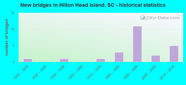
- New bridges - historical statistics
- 11930-1939
- 11950-1959
- 11970-1979
- 31980-1989
- 111990-1999
- 22000-2009
- 52010-2019


- Bridge Condition - Deck
- 5.6%Very good
- 33.3%Good
- 61.1%Satisfactory

- Bridge Condition - Superstructure
- 16.7%Very good
- 61.1%Good
- 11.1%Satisfactory
- 5.6%Fair
- 5.6%Poor

- Bridge Condition - Substructure
- 16.7%Very good
- 50.0%Good
- 22.2%Satisfactory
- 5.6%Fair
- 5.6%Poor

- Bridge Condition - Channel
- 27.3%Very good
- 72.7%Good
Find on map >> Show street view
Structure Number: 949, Location: TOWN OF MCCOLL (Lat: 34.658714, Lng: -79.561381), Route carried "on" structure: US 15, Year Built: 1939, Status: Open, Structure Length: 0.97m (3.18ft), Average Daily Traffic: 7,000 (year 2020), Truck Traffic: 9%, Average Future Daily Traffic: 11,130 (year 2040), Design Load: H 15, Features Intersected: BEAVER DAM CREEK
Minimum Vertical Clearance: 30+ m (98+ ft), Kilometerpoint: 30.698, Lanes on structure: 2, Base Highway Network: Yes, Owner: State Highway Agency, Approaching Roadway Width: 7.3m (24.0ft), Material/Design: Concrete, Design/Construction: Culvert, Number Of Spans In Main Unit: 3, Length of Maximum Span: 3.0m (9.8ft), Curb-To-Curb Width: 13.4m (44.0ft), Out-to-Out Width: 13.4m (44.0ft)
Condition: Channel: Very good, Culverts: Good, Operating Rating: 32.4 metric tons, Method Used To Determine Operating Rating: Load and Resistance Factor Rating (LRFR) rating reported by rating factor(RF) method using HL-93 loadings, Inventory Rating: 32.4 metric tons, Method Used To Determine Inventory Rating: Load and Resistance Factor Rating (LRFR) rating reported by rating factor(RF) method using HL-93 loadings, Structural Evaluation: Better than present minimum criteria, Deck Geometry: Equal to present minimum criteria, Waterway Adequacy: Equal to present desirable criteria, Approach Roadway Alignment: Equal to present desirable criteria, Length Of Structure Improvement: 0.97m (3.18ft), Designated Inspection Frequency: Every 24 months, Inspection Date: March 2020
Find on map >> Show street view
Structure Number: 2137, Location: IN HILTON HEAD ISLAND (Lat: 32.210183, Lng: -80.746519), Route carried "on" structure: State highway 79, Year Built: 2017, Status: Open, Structure Length: 14.63m (48.00ft), Average Daily Traffic: 5,700 (year 2020), Truck Traffic: 4%, Average Future Daily Traffic: 8,664 (year 2040), Design Load: HL 93, Features Intersected: JARVIS CREEK
Minimum Vertical Clearance: 30+ m (98+ ft), Kilometerpoint: 0.835, Lanes on structure: 2, Owner: State Highway Agency, Approaching Roadway Width: 8.6m (28.2ft), Skew: 1 degrees, Material/Design: Concrete continuous, Design/Construction: Slab, Number Of Spans In Main Unit: 12, Length of Maximum Span: 12.2m (40.0ft), Curb or Sidewalk Widths: Left: 0.2m (0.7ft), Right: 0.2m (0.7ft), Curb-To-Curb Width: 12.2m (40.0ft), Out-to-Out Width: 13.2m (43.3ft)
Condition: Deck: Very good, Superstructure: Very good, Substructure: Very good, Channel: Good, Operating Rating: 46.0 metric tons, Method Used To Determine Operating Rating: Load and Resistance Factor Rating (LRFR) rating reported by rating factor(RF) method using HL-93 loadings, Inventory Rating: 35.6 metric tons, Method Used To Determine Inventory Rating: Load and Resistance Factor Rating (LRFR) rating reported by rating factor(RF) method using HL-93 loadings, Structural Evaluation: Equal to present desirable criteria, Deck Geometry: Somewhat better than minimum adequacy, Waterway Adequacy: Equal to present minimum criteria, Approach Roadway Alignment: Better than present minimum criteria, Length Of Structure Improvement: 14.63m (48.00ft), Designated Inspection Frequency: Every 24 months, Inspection Date: August 2021, Deck Structure Type: Concrete Cast-file-Place, Wearing Surface/Protective System: Wearing Surface: Monolithic Concrete
Find on map >> Show street view
Structure Number: 2297, Location: @ HILTON HEAD ISLAND (Lat: 32.230508, Lng: -80.791844), Route carried "on" structure: US 278, Year Built: 1956, Year Reconstructed: 1984, Status: Open, Structure Length: 67.98m (223.03ft), Average Daily Traffic: 25,700 (year 2020), Truck Traffic: 3%, Average Future Daily Traffic: 30,840 (year 2040), Design Load: HS 15, Features Intersected: MACKAY CREEK
Minimum Vertical Clearance: 30+ m (98+ ft), Kilometerpoint: 19.653, Lanes on structure: 2, Base Highway Network: Yes, Owner: State Highway Agency, Approaching Roadway Width: 10.4m (34.1ft), Navigation Control: Yes ( Vertical Clearance: 7.6m (24.9ft), Horizontal Clearance: 18.6m (61.0ft)), Material/Design: Steel, Design/Construction: Stringer/Multi-beam, Number Of Spans In Main Unit: 1, Number Of Approach Spans: 54, Length of Maximum Span: 21.3m (69.9ft), Curb-To-Curb Width: 12.0m (39.4ft), Out-to-Out Width: 12.0m (39.4ft)
Condition: Deck: Satisfactory, Superstructure: Poor, Substructure: Poor, Channel: Good, Operating Rating: 41.8 metric tons, Method Used To Determine Operating Rating: Load and Resistance Factor Rating (LRFR) rating reported by rating factor(RF) method using HL-93 loadings, Inventory Rating: 31.4 metric tons, Method Used To Determine Inventory Rating: Load and Resistance Factor Rating (LRFR) rating reported by rating factor(RF) method using HL-93 loadings, Structural Evaluation: Meets minimum limits, Deck Geometry: Better than present minimum criteria, Waterway Adequacy: Equal to present desirable criteria, Approach Roadway Alignment: Equal to present desirable criteria, Length Of Structure Improvement: 67.97m (223.00ft), Designated Inspection Frequency: Every 12 months, Underwater Inspection Frequency: Every 60 months, Inspection Date: September 2021, Underwater Inspection Date: January 2019, Bridge Improvement Cost: $3,308,000, Roadway Improvement Cost: $165,000, Total Project Cost: $3,639,000 ( Estimate for 2021), Deck Structure Type: Concrete Cast-file-Place, Wearing Surface/Protective System: Wearing Surface: Bituminous
Find on map >> Show street view
Structure Number: 7069, Location: HILTON HEAD ISLAND (Lat: 32.180247, Lng: -80.724667), Route carried "on" structure: Business US 278, Year Built: 1978, Status: Open, Structure Length: 4.02m (13.19ft), Average Daily Traffic: 16,350 (year 2020), Truck Traffic: 2%, Average Future Daily Traffic: 19,620 (year 2040), Design Load: HS 20, Features Intersected: PALMETTO LAGOON
Minimum Vertical Clearance: 30+ m (98+ ft), Kilometerpoint: 9.891, Lanes on structure: 2, Base Highway Network: Yes, Owner: State Highway Agency, Approaching Roadway Width: 7.0m (23.0ft), Material/Design: Concrete, Design/Construction: Slab, Number Of Spans In Main Unit: 6, Length of Maximum Span: 6.7m (22.0ft), Curb-To-Curb Width: 12.0m (39.4ft), Out-to-Out Width: 13.1m (43.0ft)
Condition: Deck: Good, Superstructure: Good, Substructure: Good, Channel: Good, Operating Rating: 38.9 metric tons, Method Used To Determine Operating Rating: Load and Resistance Factor Rating (LRFR) rating reported by rating factor(RF) method using HL-93 loadings, Inventory Rating: 30.1 metric tons, Method Used To Determine Inventory Rating: Load and Resistance Factor Rating (LRFR) rating reported by rating factor(RF) method using HL-93 loadings, Structural Evaluation: Better than present minimum criteria, Deck Geometry: Better than present minimum criteria, Waterway Adequacy: Equal to present minimum criteria, Approach Roadway Alignment: Equal to present desirable criteria, Length Of Structure Improvement: 4.02m (13.19ft), Designated Inspection Frequency: Every 24 months, Underwater Inspection Frequency: Every 60 months, Inspection Date: August 2020, Underwater Inspection Date: May 2021, Deck Structure Type: Concrete Cast-file-Place, Wearing Surface/Protective System: Wearing Surface: Monolithic Concrete
Find on map >> Show street view
Structure Number: 7537, Location: ON HILTON HEAD ISLAND (Lat: 32.224647, Lng: -80.781694), Route carried "on" structure: US 278, Year Built: 1982, Status: Open, Structure Length: 86.01m (282.19ft), Average Daily Traffic: 25,700 (year 2020), Truck Traffic: 3%, Average Future Daily Traffic: 30,840 (year 2040), Design Load: HS 20, Features Intersected: SKULL CREEK
Minimum Vertical Clearance: 30+ m (98+ ft), Kilometerpoint: 20.651, Lanes on structure: 2, Base Highway Network: Yes, Owner: State Highway Agency, Approaching Roadway Width: 12.2m (40.0ft), Navigation Control: Yes ( Vertical Clearance: 19.8m (65.0ft), Horizontal Clearance: 38.1m (125.0ft)), Material/Design: Steel continuous, Design/Construction: Stringer/Multi-beam, Number Of Spans In Main Unit: 11, Number Of Approach Spans: 21, Length of Maximum Span: 54.9m (180.1ft), Curb-To-Curb Width: 11.0m (36.1ft), Out-to-Out Width: 12.0m (39.4ft)
Condition: Deck: Satisfactory, Superstructure: Satisfactory, Substructure: Satisfactory, Channel: Good, Operating Rating: 24.0 metric tons, Method Used To Determine Operating Rating: Load and Resistance Factor Rating (LRFR) rating reported by rating factor(RF) method using HL-93 loadings, Inventory Rating: 18.5 metric tons, Method Used To Determine Inventory Rating: Load and Resistance Factor Rating (LRFR) rating reported by rating factor(RF) method using HL-93 loadings, Structural Evaluation: Meets minimum limits, Deck Geometry: Equal to present minimum criteria, Waterway Adequacy: Equal to present desirable criteria, Approach Roadway Alignment: Equal to present desirable criteria, Length Of Structure Improvement: 86.01m (282.19ft), Designated Inspection Frequency: Every 24 months, Underwater Inspection Frequency: Every 60 months, Inspection Date: September 2020, Underwater Inspection Date: January 2019, Deck Structure Type: Concrete Cast-file-Place, Wearing Surface/Protective System: Wearing Surface: Monolithic Concrete
Find on map >> Show street view
Structure Number: 7538, Location: HILTON HEAD ISLAND (Lat: 32.224600, Lng: -80.781464), Route carried "on" structure: US 278, Year Built: 1982, Status: Open, Structure Length: 86.01m (282.19ft), Average Daily Traffic: 25,700 (year 2020), Truck Traffic: 3%, Average Future Daily Traffic: 30,840 (year 2040), Design Load: HS 20, Features Intersected: SKULL CREEK
Minimum Vertical Clearance: 30+ m (98+ ft), Kilometerpoint: 20.555, Lanes on structure: 2, Base Highway Network: Yes, Owner: State Highway Agency, Approaching Roadway Width: 12.2m (40.0ft), Navigation Control: Yes ( Vertical Clearance: 19.8m (65.0ft), Horizontal Clearance: 38.1m (125.0ft)), Material/Design: Steel continuous, Design/Construction: Stringer/Multi-beam, Number Of Spans In Main Unit: 11, Number Of Approach Spans: 21, Length of Maximum Span: 54.9m (180.1ft), Curb-To-Curb Width: 11.0m (36.1ft), Out-to-Out Width: 12.0m (39.4ft)
Condition: Deck: Satisfactory, Superstructure: Satisfactory, Substructure: Satisfactory, Channel: Good, Operating Rating: 24.6 metric tons, Method Used To Determine Operating Rating: Load and Resistance Factor Rating (LRFR) rating reported by rating factor(RF) method using HL-93 loadings, Inventory Rating: 19.1 metric tons, Method Used To Determine Inventory Rating: Load and Resistance Factor Rating (LRFR) rating reported by rating factor(RF) method using HL-93 loadings, Structural Evaluation: Meets minimum limits, Deck Geometry: Equal to present minimum criteria, Waterway Adequacy: Equal to present desirable criteria, Approach Roadway Alignment: Equal to present desirable criteria, Length Of Structure Improvement: 86.01m (282.19ft), Designated Inspection Frequency: Every 24 months, Underwater Inspection Frequency: Every 60 months, Inspection Date: September 2020, Underwater Inspection Date: January 2019, Deck Structure Type: Concrete Cast-file-Place, Wearing Surface/Protective System: Wearing Surface: Monolithic Concrete
Find on map >> Show street view
Structure Number: 765, Location: HILTON HEAD ISLAND (Lat: 32.230675, Lng: -80.791767), Route carried "on" structure: US 278, Year Built: 1983, Status: Open, Structure Length: 68.00m (223.10ft), Average Daily Traffic: 25,700 (year 2020), Truck Traffic: 3%, Average Future Daily Traffic: 30,840 (year 2040), Design Load: HS 20, Features Intersected: MACKAY CREEK
Minimum Vertical Clearance: 30+ m (98+ ft), Kilometerpoint: 19.592, Lanes on structure: 2, Base Highway Network: Yes, Owner: State Highway Agency, Approaching Roadway Width: 11.0m (36.1ft), Navigation Control: Yes ( Vertical Clearance: 7.6m (24.9ft), Horizontal Clearance: 18.6m (61.0ft)), Material/Design: Steel, Design/Construction: Stringer/Multi-beam, Number Of Spans In Main Unit: 1, Number Of Approach Spans: 55, Length of Maximum Span: 21.6m (70.9ft), Curb-To-Curb Width: 11.0m (36.1ft), Out-to-Out Width: 12.0m (39.4ft)
Condition: Deck: Satisfactory, Superstructure: Fair, Substructure: Fair, Channel: Good, Operating Rating: 57.7 metric tons, Method Used To Determine Operating Rating: Load and Resistance Factor Rating (LRFR) rating reported by rating factor(RF) method using HL-93 loadings, Inventory Rating: 29.2 metric tons, Method Used To Determine Inventory Rating: Load and Resistance Factor Rating (LRFR) rating reported by rating factor(RF) method using HL-93 loadings, Structural Evaluation: Somewhat better than minimum adequacy, Deck Geometry: Equal to present minimum criteria, Waterway Adequacy: Equal to present desirable criteria, Approach Roadway Alignment: Equal to present desirable criteria, Length Of Structure Improvement: 68.00m (223.10ft), Designated Inspection Frequency: Every 24 months, Underwater Inspection Frequency: Every 60 months, Inspection Date: September 2020, Underwater Inspection Date: January 2019, Deck Structure Type: Concrete Cast-file-Place, Wearing Surface/Protective System: Wearing Surface: Monolithic Concrete
Find on map >> Show street view
Structure Number: 9127, Location: HILTON HEAD ISLAND (Lat: 32.215467, Lng: -80.740108), Route carried "on" structure: US 278, Year Built: 1997, Status: Open, Structure Length: 4.08m (13.39ft), Average Daily Traffic: 11,850 (year 2020), Truck Traffic: 4%, Average Future Daily Traffic: 14,220 (year 2040), Design Load: HS 20+Mod, Features Intersected: US 278 BUS EB
Minimum Vertical Clearance: 30+ m (98+ ft), Kilometerpoint: 25.235, Lanes on structure: 2, Lanes under structure: 3, Base Highway Network: Yes, Owner: State Highway Agency, Approaching Roadway Width: 7.5m (24.6ft), Skew: 3 degrees, Material/Design: Steel, Design/Construction: Stringer/Multi-beam, Number Of Spans In Main Unit: 1, Length of Maximum Span: 40.8m (133.9ft), Curb-To-Curb Width: 11.6m (38.1ft), Out-to-Out Width: 12.5m (41.0ft)
Condition: Deck: Satisfactory, Superstructure: Good, Substructure: Good, Operating Rating: 50.2 metric tons, Method Used To Determine Operating Rating: Load and Resistance Factor Rating (LRFR) rating reported by rating factor(RF) method using HL-93 loadings, Inventory Rating: 38.6 metric tons, Method Used To Determine Inventory Rating: Load and Resistance Factor Rating (LRFR) rating reported by rating factor(RF) method using HL-93 loadings, Structural Evaluation: Better than present minimum criteria, Deck Geometry: Better than present minimum criteria, Underclear: Superior to present desirable criteria, Approach Roadway Alignment: Equal to present desirable criteria, Length Of Structure Improvement: 4.08m (13.39ft), Designated Inspection Frequency: Every 24 months, Inspection Date: August 2020, Deck Structure Type: Concrete Cast-file-Place, Wearing Surface/Protective System: Wearing Surface: Bituminous
Find on map >> Show street view
Structure Number: 9128, Location: HILTON HEAD ISLAND (Lat: 32.214381, Lng: -80.738619), Route carried "on" structure: US 278, Year Built: 1997, Status: Open, Structure Length: 7.32m (24.02ft), Average Daily Traffic: 11,850 (year 2020), Truck Traffic: 4%, Average Future Daily Traffic: 14,220 (year 2040), Design Load: HS 20+Mod, Features Intersected: RAMP 5012
Minimum Vertical Clearance: 30+ m (98+ ft), Kilometerpoint: 25.407, Lanes on structure: 2, Lanes under structure: 3, Base Highway Network: Yes, Toll: On toll road, Owner: State Highway Agency, Approaching Roadway Width: 7.5m (24.6ft), Skew: 2 degrees, Material/Design: Steel continuous, Design/Construction: Stringer/Multi-beam, Number Of Spans In Main Unit: 3, Length of Maximum Span: 33.5m (109.9ft), Curb-To-Curb Width: 11.6m (38.1ft), Out-to-Out Width: 12.5m (41.0ft)
Condition: Deck: Satisfactory, Superstructure: Good, Substructure: Good, Operating Rating: 56.7 metric tons, Method Used To Determine Operating Rating: Load and Resistance Factor Rating (LRFR) rating reported by rating factor(RF) method using HL-93 loadings, Inventory Rating: 42.8 metric tons, Method Used To Determine Inventory Rating: Load and Resistance Factor Rating (LRFR) rating reported by rating factor(RF) method using HL-93 loadings, Structural Evaluation: Better than present minimum criteria, Deck Geometry: Better than present minimum criteria, Underclear: Superior to present desirable criteria, Approach Roadway Alignment: Equal to present desirable criteria, Length Of Structure Improvement: 7.32m (24.02ft), Designated Inspection Frequency: Every 24 months, Inspection Date: August 2020, Deck Structure Type: Concrete Cast-file-Place, Wearing Surface/Protective System: Wearing Surface: Bituminous
Find on map >> Show street view
Structure Number: 9129, Location: HILTON HEAD ISLAND (Lat: 32.192422, Lng: -80.764914), Route carried "on" structure: US 278, Year Built: 1997, Status: Open, Structure Length: 5.33m (17.49ft), Average Daily Traffic: 11,850 (year 2020), Truck Traffic: 4%, Average Future Daily Traffic: 14,220 (year 2040), Design Load: HS 20, Features Intersected: S-245/MARSHLAND RD
Minimum Vertical Clearance: 30+ m (98+ ft), Kilometerpoint: 29.071, Lanes on structure: 2, Lanes under structure: 4, Base Highway Network: Yes, Toll: On toll road, Owner: State Highway Agency, Approaching Roadway Width: 11.6m (38.1ft), Material/Design: Prestressed concrete, Design/Construction: Stringer/Multi-beam, Number Of Spans In Main Unit: 3, Length of Maximum Span: 25.9m (85.0ft), Curb-To-Curb Width: 11.6m (38.1ft), Out-to-Out Width: 12.4m (40.7ft)
Condition: Deck: Satisfactory, Superstructure: Good, Substructure: Good, Operating Rating: 54.1 metric tons, Method Used To Determine Operating Rating: Load and Resistance Factor Rating (LRFR) rating reported by rating factor(RF) method using HL-93 loadings, Inventory Rating: 31.1 metric tons, Method Used To Determine Inventory Rating: Load and Resistance Factor Rating (LRFR) rating reported by rating factor(RF) method using HL-93 loadings, Structural Evaluation: Better than present minimum criteria, Deck Geometry: Better than present minimum criteria, Underclear: Equal to present desirable criteria, Approach Roadway Alignment: Equal to present desirable criteria, Length Of Structure Improvement: 5.33m (17.49ft), Designated Inspection Frequency: Every 24 months, Inspection Date: August 2020, Deck Structure Type: Concrete Cast-file-Place, Wearing Surface/Protective System: Wearing Surface: Monolithic Concrete
Find on map >> Show street view
Structure Number: 913, Location: HILTON HEAD ISLAND (Lat: 32.215564, Lng: -80.739806), Route carried "on" structure: US 278, Year Built: 1997, Status: Open, Structure Length: 4.05m (13.29ft), Average Daily Traffic: 11,850 (year 2020), Truck Traffic: 4%, Average Future Daily Traffic: 14,220 (year 2040), Design Load: HS 20+Mod, Features Intersected: US 278 BUS EB
Minimum Vertical Clearance: 30+ m (98+ ft), Kilometerpoint: 25.265, Lanes on structure: 2, Lanes under structure: 3, Base Highway Network: Yes, Toll: On toll road, Owner: State Highway Agency, Approaching Roadway Width: 7.5m (24.6ft), Skew: 3 degrees, Material/Design: Steel, Design/Construction: Stringer/Multi-beam, Number Of Spans In Main Unit: 1, Length of Maximum Span: 40.5m (132.9ft), Curb-To-Curb Width: 11.6m (38.1ft), Out-to-Out Width: 12.5m (41.0ft)
Condition: Deck: Satisfactory, Superstructure: Good, Substructure: Good, Operating Rating: 52.5 metric tons, Method Used To Determine Operating Rating: Load and Resistance Factor Rating (LRFR) rating reported by rating factor(RF) method using HL-93 loadings, Inventory Rating: 40.5 metric tons, Method Used To Determine Inventory Rating: Load and Resistance Factor Rating (LRFR) rating reported by rating factor(RF) method using HL-93 loadings, Structural Evaluation: Better than present minimum criteria, Deck Geometry: Better than present minimum criteria, Underclear: Better than present minimum criteria, Approach Roadway Alignment: Equal to present desirable criteria, Length Of Structure Improvement: 4.05m (13.29ft), Designated Inspection Frequency: Every 24 months, Inspection Date: August 2020, Deck Structure Type: Concrete Cast-file-Place, Wearing Surface/Protective System: Wearing Surface: Monolithic Concrete
Find on map >> Show street view
Structure Number: 9131, Location: HILTON HEAD ISLAND (Lat: 32.214597, Lng: -80.738500), Route carried "on" structure: US 278, Year Built: 1997, Status: Open, Structure Length: 7.22m (23.69ft), Average Daily Traffic: 11,850 (year 2020), Truck Traffic: 4%, Average Future Daily Traffic: 14,220 (year 2040), Design Load: HS 20+Mod, Features Intersected: S-482/GUMTREE ROAD
Minimum Vertical Clearance: 6.60m (21.65ft), Kilometerpoint: 25.416, Lanes on structure: 2, Lanes under structure: 3, Base Highway Network: Yes, Toll: On toll road, Owner: State Highway Agency, Approaching Roadway Width: 7.5m (24.6ft), Skew: 2 degrees, Material/Design: Steel continuous, Design/Construction: Stringer/Multi-beam, Number Of Spans In Main Unit: 3, Length of Maximum Span: 31.7m (104.0ft), Curb-To-Curb Width: 11.6m (38.1ft), Out-to-Out Width: 12.5m (41.0ft)
Condition: Deck: Satisfactory, Superstructure: Good, Substructure: Satisfactory, Operating Rating: 59.6 metric tons, Method Used To Determine Operating Rating: Load and Resistance Factor Rating (LRFR) rating reported by rating factor(RF) method using HL-93 loadings, Inventory Rating: 45.4 metric tons, Method Used To Determine Inventory Rating: Load and Resistance Factor Rating (LRFR) rating reported by rating factor(RF) method using HL-93 loadings, Structural Evaluation: Equal to present minimum criteria, Deck Geometry: Better than present minimum criteria, Underclear: Superior to present desirable criteria, Approach Roadway Alignment: Equal to present desirable criteria, Length Of Structure Improvement: 7.22m (23.69ft), Designated Inspection Frequency: Every 24 months, Inspection Date: August 2020, Deck Structure Type: Concrete Cast-file-Place, Wearing Surface/Protective System: Wearing Surface: Monolithic Concrete
Find on map >> Show street view
Structure Number: 9132, Location: HILTON HEAD ISLAND (Lat: 32.192347, Lng: -80.764686), Route carried "on" structure: US 278, Year Built: 1997, Status: Open, Structure Length: 5.09m (16.70ft), Average Daily Traffic: 11,850 (year 2020), Truck Traffic: 4%, Average Future Daily Traffic: 14,220 (year 2040), Design Load: HS 20, Features Intersected: S-245/MARSHLAND ROAD
Minimum Vertical Clearance: 30+ m (98+ ft), Kilometerpoint: 29.115, Lanes on structure: 2, Lanes under structure: 4, Base Highway Network: Yes, Toll: On toll road, Owner: State Highway Agency, Approaching Roadway Width: 7.4m (24.3ft), Material/Design: Prestressed concrete, Design/Construction: Stringer/Multi-beam, Number Of Spans In Main Unit: 3, Length of Maximum Span: 25.9m (85.0ft), Curb-To-Curb Width: 11.6m (38.1ft), Out-to-Out Width: 12.5m (41.0ft)
Condition: Deck: Satisfactory, Superstructure: Good, Substructure: Good, Operating Rating: 55.7 metric tons, Method Used To Determine Operating Rating: Load and Resistance Factor Rating (LRFR) rating reported by rating factor(RF) method using HL-93 loadings, Inventory Rating: 27.9 metric tons, Method Used To Determine Inventory Rating: Load and Resistance Factor Rating (LRFR) rating reported by rating factor(RF) method using HL-93 loadings, Structural Evaluation: Better than present minimum criteria, Deck Geometry: Better than present minimum criteria, Underclear: Superior to present desirable criteria, Approach Roadway Alignment: Equal to present desirable criteria, Length Of Structure Improvement: 5.09m (16.70ft), Designated Inspection Frequency: Every 24 months, Inspection Date: August 2020, Deck Structure Type: Concrete Cast-file-Place, Wearing Surface/Protective System: Wearing Surface: Monolithic Concrete
Find on map >> Show street view
Structure Number: 949, Location: IN HILTON HEAD (Lat: 32.189772, Lng: -80.701794), Route carried "on" structure: State highway 200, Year Built: 2000, Status: Open, Structure Length: 2.74m (8.99ft), Average Daily Traffic: 800 (year 2020), Truck Traffic: 5%, Average Future Daily Traffic: 1,024 (year 2040), Design Load: HS 25 or greater, Features Intersected: SALTWATER CREEK
Minimum Vertical Clearance: 30+ m (98+ ft), Kilometerpoint: 0.607, Lanes on structure: 2, Owner: State Highway Agency, Approaching Roadway Width: 6.1m (20.0ft), Material/Design: Concrete continuous, Design/Construction: Slab, Number Of Spans In Main Unit: 3, Length of Maximum Span: 9.1m (29.9ft), Curb-To-Curb Width: 11.0m (36.1ft), Out-to-Out Width: 11.8m (38.7ft)
Condition: Deck: Good, Superstructure: Good, Substructure: Good, Channel: Good, Operating Rating: 61.2 metric tons, Method Used To Determine Operating Rating: Load and Resistance Factor Rating (LRFR) rating reported by rating factor(RF) method using HL-93 loadings, Inventory Rating: 47.3 metric tons, Method Used To Determine Inventory Rating: Load and Resistance Factor Rating (LRFR) rating reported by rating factor(RF) method using HL-93 loadings, Structural Evaluation: Better than present minimum criteria, Deck Geometry: Better than present minimum criteria, Waterway Adequacy: Equal to present minimum criteria, Approach Roadway Alignment: Equal to present desirable criteria, Length Of Structure Improvement: 2.74m (8.99ft), Designated Inspection Frequency: Every 24 months, Inspection Date: August 2021, Deck Structure Type: Concrete Cast-file-Place, Wearing Surface/Protective System: Wearing Surface: Monolithic Concrete
Find on map >> Show street view
Structure Number: 9556, Location: HILTON HEAD ISLAND (Lat: 32.180111, Lng: -80.724547), Route carried "on" structure: Business US 278, Year Built: 2001, Status: Open, Structure Length: 3.66m (12.01ft), Average Daily Traffic: 16,350 (year 2020), Truck Traffic: 2%, Average Future Daily Traffic: 19,620 (year 2040), Design Load: HS 25 or greater, Features Intersected: PALMETTO LAGOON
Minimum Vertical Clearance: 30+ m (98+ ft), Kilometerpoint: 9.891, Lanes on structure: 2, Base Highway Network: Yes, Owner: State Highway Agency, Approaching Roadway Width: 7.1m (23.3ft), Material/Design: Prestressed concrete continuous, Design/Construction: Stringer/Multi-beam, Number Of Spans In Main Unit: 3, Length of Maximum Span: 12.2m (40.0ft), Curb-To-Curb Width: 13.4m (44.0ft), Out-to-Out Width: 14.3m (46.9ft)
Condition: Deck: Good, Superstructure: Good, Substructure: Good, Channel: Good, Operating Rating: 15.9 metric tons, Method Used To Determine Operating Rating: Load and Resistance Factor Rating (LRFR) rating reported by rating factor(RF) method using HL-93 loadings, Inventory Rating: 12.3 metric tons, Method Used To Determine Inventory Rating: Load and Resistance Factor Rating (LRFR) rating reported by rating factor(RF) method using HL-93 loadings, Structural Evaluation: High priority of corrective action, Deck Geometry: Superior to present desirable criteria, Waterway Adequacy: Equal to present desirable criteria, Approach Roadway Alignment: Equal to present desirable criteria, Length Of Structure Improvement: 4.54m (14.90ft), Designated Inspection Frequency: Every 24 months, Underwater Inspection Frequency: Every 60 months, Inspection Date: August 2020, Underwater Inspection Date: May 2021, Bridge Improvement Cost: $148,000, Roadway Improvement Cost: $37,000, Total Project Cost: $222,000 ( Estimate for 2021), Deck Structure Type: Concrete Cast-file-Place, Wearing Surface/Protective System: Wearing Surface: Monolithic Concrete
Find on map >> Show street view
Structure Number: 9889, Location: HILTON HEAD (Lat: 32.180267, Lng: -80.767764), Route carried "on" structure: US 278, Year Built: 1994, Status: Open, Structure Length: 107.53m (352.79ft), Average Daily Traffic: 23,700 (year 2020), Truck Traffic: 4%, Average Future Daily Traffic: 28,440 (year 2040), Design Load: HS 20+Mod, Features Intersected: BROAD CREEK
Minimum Vertical Clearance: 30+ m (98+ ft), Kilometerpoint: 29.945, Lanes on structure: 4, Base Highway Network: Yes, Owner: State Highway Agency, Approaching Roadway Width: 20.7m (67.9ft), Material/Design: Steel continuous, Design/Construction: Stringer/Multi-beam, Number Of Spans In Main Unit: 5, Number Of Approach Spans: 30, Length of Maximum Span: 61.0m (200.1ft), Curb-To-Curb Width: 23.6m (77.4ft), Out-to-Out Width: 25.2m (82.7ft)
Condition: Deck: Satisfactory, Superstructure: Good, Substructure: Satisfactory, Channel: Very good, Operating Rating: 37.3 metric tons, Method Used To Determine Operating Rating: Load and Resistance Factor Rating (LRFR) rating reported by rating factor(RF) method using HL-93 loadings, Inventory Rating: 27.9 metric tons, Method Used To Determine Inventory Rating: Load and Resistance Factor Rating (LRFR) rating reported by rating factor(RF) method using HL-93 loadings, Structural Evaluation: Equal to present minimum criteria, Deck Geometry: Superior to present desirable criteria, Approach Roadway Alignment: Equal to present desirable criteria, Length Of Structure Improvement: 107.53m (352.79ft), Designated Inspection Frequency: Every 24 months, Underwater Inspection Frequency: Every 60 months, Inspection Date: September 2020, Underwater Inspection Date: April 2021, Deck Structure Type: Concrete Cast-file-Place, Wearing Surface/Protective System: Wearing Surface: Monolithic Concrete
Find on map >> Show street view
Structure Number: 10062, Location: 4 MI SE OF BLUFFTON (Lat: 32.232775, Lng: -80.805631), Route carried "on" structure: County highway 1526, Year Built: 2016, Status: Open, Structure Length: 36.30m (119.09ft), Average Daily Traffic: 177,000 (year 2020), Truck Traffic: 2%, Average Future Daily Traffic: 219,480 (year 2040), Design Load: HL 93, Features Intersected: TIDAL MARSH
Minimum Vertical Clearance: 30+ m (98+ ft), Kilometerpoint: 10.855, Lanes on structure: 2, Base Highway Network: Yes, Owner: County Highway Agency, Approaching Roadway Width: 14.3m (46.9ft), Material/Design: Prestressed concrete continuous, Design/Construction: Stringer/Multi-beam, Number Of Spans In Main Unit: 13, Length of Maximum Span: 29.0m (95.1ft), Curb-To-Curb Width: 14.3m (46.9ft), Out-to-Out Width: 15.6m (51.2ft)
Condition: Deck: Good, Superstructure: Very good, Substructure: Very good, Operating Rating: 39.5 metric tons, Method Used To Determine Operating Rating: Load and Resistance Factor Rating (LRFR) rating reported by rating factor(RF) method using HL-93 loadings, Inventory Rating: 21.4 metric tons, Method Used To Determine Inventory Rating: Load and Resistance Factor Rating (LRFR) rating reported by rating factor(RF) method using HL-93 loadings, Structural Evaluation: Somewhat better than minimum adequacy, Deck Geometry: Superior to present desirable criteria, Approach Roadway Alignment: Equal to present desirable criteria, Length Of Structure Improvement: 36.29m (119.06ft), Designated Inspection Frequency: Every 24 months, Inspection Date: August 2021, Bridge Improvement Cost: $1,573,000, Roadway Improvement Cost: $393,000, Total Project Cost: $2,360,000 ( Estimate for 2021), Deck Structure Type: Concrete Cast-file-Place, Wearing Surface/Protective System: Wearing Surface: Monolithic Concrete
Find on map >> Show street view
Structure Number: 10063, Location: 4 SE OF BLUFFTON (Lat: 32.234128, Lng: -80.802364), Route carried "on" structure: County highway 1526, Year Built: 2016, Status: Open, Structure Length: 41.61m (136.52ft), Average Daily Traffic: 88,500 (year 2020), Truck Traffic: 2%, Average Future Daily Traffic: 99,120 (year 2040), Design Load: HL 93, Features Intersected: TIDAL MARSH
Minimum Vertical Clearance: 6.53m (21.42ft), Kilometerpoint: 11.272, Lanes on structure: 1, Lanes under structure: 4, Owner: County Highway Agency, Approaching Roadway Width: 9.1m (29.9ft), Material/Design: Steel continuous, Design/Construction: Stringer/Multi-beam, Number Of Spans In Main Unit: 3, Number Of Approach Spans: 14, Length of Maximum Span: 53.3m (174.9ft), Curb-To-Curb Width: 11.0m (36.1ft), Out-to-Out Width: 12.0m (39.4ft)
Condition: Deck: Good, Superstructure: Very good, Substructure: Very good, Channel: Very good, Operating Rating: 37.3 metric tons, Method Used To Determine Operating Rating: Load and Resistance Factor Rating (LRFR) rating reported by rating factor(RF) method using HL-93 loadings, Inventory Rating: 28.8 metric tons, Method Used To Determine Inventory Rating: Load and Resistance Factor Rating (LRFR) rating reported by rating factor(RF) method using HL-93 loadings, Structural Evaluation: Better than present minimum criteria, Deck Geometry: Meets minimum limits, Underclear: Superior to present desirable criteria, Waterway Adequacy: Equal to present minimum criteria, Approach Roadway Alignment: Equal to present desirable criteria, Length Of Structure Improvement: 41.61m (136.52ft), Designated Inspection Frequency: Every 24 months, Inspection Date: August 2021, Deck Structure Type: Concrete Cast-file-Place, Wearing Surface/Protective System: Wearing Surface: Monolithic Concrete
Find on map >> Show street view
Structure Number: 10064, Location: 4 SE OF BLUFFTON (Lat: 32.234669, Lng: -80.802153), Route carried "on" structure: County highway 1526, Year Built: 2016, Status: Open, Structure Length: 47.95m (157.32ft), Average Daily Traffic: 8,850 (year 2021), Truck Traffic: 2%, Average Future Daily Traffic: 10,974 (year 2041), Design Load: HL 93, Features Intersected: S-242
Minimum Vertical Clearance: 6.32m (20.73ft), Kilometerpoint: 11.222, Lanes on structure: 2, Lanes under structure: 6, Base Highway Network: Yes, Owner: County Highway Agency, Approaching Roadway Width: 10.7m (35.1ft), Material/Design: Steel continuous, Design/Construction: Stringer/Multi-beam, Number Of Spans In Main Unit: 2, Number Of Approach Spans: 19, Length of Maximum Span: 48.8m (160.1ft), Curb-To-Curb Width: 11.0m (36.1ft), Out-to-Out Width: 12.0m (39.4ft)
Condition: Deck: Good, Superstructure: Good, Substructure: Good, Operating Rating: 34.0 metric tons, Method Used To Determine Operating Rating: Load and Resistance Factor Rating (LRFR) rating reported by rating factor(RF) method using HL-93 loadings, Inventory Rating: 26.2 metric tons, Method Used To Determine Inventory Rating: Load and Resistance Factor Rating (LRFR) rating reported by rating factor(RF) method using HL-93 loadings, Structural Evaluation: Equal to present minimum criteria, Deck Geometry: Equal to present minimum criteria, Underclear: Superior to present desirable criteria, Approach Roadway Alignment: Equal to present desirable criteria, Length Of Structure Improvement: 47.95m (157.32ft), Designated Inspection Frequency: Every 24 months, Inspection Date: August 2021, Deck Structure Type: Concrete Cast-file-Place, Wearing Surface/Protective System: Wearing Surface: Monolithic Concrete
Find on map >> Show street view
Structure Number: 9127, Location: HILTON HEAD ISLAND (Lat: 32.215467, Lng: -80.740108), Route carried "under" structure: State highway 245, Year Built: 1997, Structure Length: 0. m, Average Daily Traffic: 4,100 (year 2020), Truck Traffic: 2%, Features Intersected: US 278 BUS EB, Facility Carried by Structure: US 278 EB
Minimum Vertical Clearance: 5.33m (17.49ft), Kilometerpoint: 1.706, Lanes on structure: 2, Lanes under structure: 3, Material/Design: Steel, Design/Construction: Stringer/Multi-beam, Length of Maximum Span: 40.8m (133.9ft)
Find on map >> Show street view
Structure Number: 9129, Location: HILTON HEAD ISLAND (Lat: 32.192422, Lng: -80.764914), Route carried "under" structure: State highway 245, Year Built: 1997, Structure Length: 0. m, Average Daily Traffic: 4,100 (year 2020), Truck Traffic: 2%, Features Intersected: S-245/MARSHLAND RD, Facility Carried by Structure: US 278 EB
Minimum Vertical Clearance: 5.66m (18.57ft), Kilometerpoint: 1.477, Lanes on structure: 2, Lanes under structure: 3, Toll: On toll road, Material/Design: Prestressed concrete, Design/Construction: Stringer/Multi-beam, Length of Maximum Span: 25.9m (85.0ft)
Find on map >> Show street view
Structure Number: 913, Location: HILTON HEAD ISLAND (Lat: 32.215564, Lng: -80.739806), Route carried "under" structure: Business US 278, Year Built: 1997, Structure Length: 0. m, Average Daily Traffic: 17,250 (year 2020), Truck Traffic: 3%, Features Intersected: US 278 BUS EB
Minimum Vertical Clearance: 5.92m (19.42ft), Kilometerpoint: 0.632, Lanes on structure: 2, Lanes under structure: 3, Toll: On toll road, Material/Design: Steel, Design/Construction: Stringer/Multi-beam, Length of Maximum Span: 40.5m (132.9ft)
Find on map >> Show street view
Structure Number: 9132, Location: HILTON HEAD ISLAND (Lat: 32.192347, Lng: -80.764686), Route carried "under" structure: State highway 245, Year Built: 1997, Structure Length: 0. m, Average Daily Traffic: 4,100 (year 2020), Truck Traffic: 2%, Features Intersected: S-245/MARSHLAND ROAD, Facility Carried by Structure: US 278 WB
Minimum Vertical Clearance: 6.02m (19.75ft), Kilometerpoint: 1.506, Lanes on structure: 2, Lanes under structure: 4, Toll: On toll road, Material/Design: Prestressed concrete, Design/Construction: Stringer/Multi-beam, Length of Maximum Span: 25.9m (85.0ft)
Find on map >> Show street view
Structure Number: 10064, Location: 4 SE OF BLUFFTON (Lat: 32.234669, Lng: -80.802153), Route carried "under" structure: State highway 242, Year Built: 2016, Structure Length: 0. m, Average Daily Traffic: 137 (year 2021), Truck Traffic: 5%, Features Intersected: S-242, Facility Carried by Structure: L-1526 WB
Minimum Vertical Clearance: 6.32m (20.73ft), Kilometerpoint: 0.105, Lanes on structure: 2, Lanes under structure: 6, Material/Design: Steel continuous, Design/Construction: Stringer/Multi-beam, Length of Maximum Span: 48.8m (160.1ft)