Bridge Statistics for Hilliard, Ohio (OH)
Condition, Traffic, Stress, Structural Evaluation, Project Costs
- National Bridge Inventory (NBI) Statistics
- 29Number of bridges
- 269ft / 82.2mTotal length
- 664,021Total average daily traffic
- 78,773Total average daily truck traffic
- National Bridge Inventory (NBI) Registered Bridges for Hilliard
- No street view available for this location
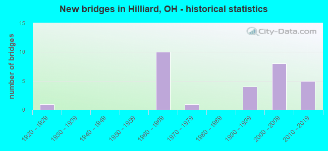
- New bridges - historical statistics
- 11920-1929
- 101960-1969
- 11970-1979
- 41990-1999
- 82000-2009
- 52010-2019

- Reconstructed bridges - Historical Statistics
- 11970-1979
- 01980-1989
- 21990-1999
- 12000-2009


- Bridge Condition - Deck
- 58.3%Very good
- 41.7%Good

- Bridge Condition - Superstructure
- 8.3%Excellent
- 58.3%Very good
- 25.0%Good
- 8.3%Satisfactory

- Bridge Condition - Substructure
- 8.3%Excellent
- 58.3%Very good
- 16.7%Good
- 16.7%Satisfactory

- Bridge Condition - Channel
- 73.7%Very good
- 15.8%Good
- 5.3%Satisfactory
- 5.3%Fair

- Bridge Condition - Culverts
- 92.3%Very good
- 7.7%Satisfactory
Find on map >> Show street view
Structure Number: 2509873, Location: 3.11 MI N OF I-70 (Lat: 40.021611, Lng: -83.121489), Route carried "on" structure: Interstate 270, Year Built: 1968, Status: Open, Structure Length: 9.10m (29.86ft), Average Daily Traffic: 57,141 (year 2015), Truck Traffic: 14%, Average Future Daily Traffic: 79,312 (year 2035), Design Load: HS 20+Mod, Features Intersected: 0VER CSX RR
Minimum Vertical Clearance: 30+ m (98+ ft), Kilometerpoint: 18.990, Lanes on structure: 3, Base Highway Network: Yes, Owner: State Highway Agency, Approaching Roadway Width: 18.6m (61.0ft), Skew: 5 degrees, Material/Design: Steel continuous, Design/Construction: Stringer/Multi-beam, Number Of Spans In Main Unit: 3, Length of Maximum Span: 34.4m (112.9ft), Curb-To-Curb Width: 18.6m (61.0ft), Out-to-Out Width: 19.5m (64.0ft)
Condition: Deck: Very good, Superstructure: Very good, Substructure: Very good, Operating Rating: 35.6 metric tons, Method Used To Determine Operating Rating: Allowable Stress (AS) rating reported by rating factor (RF) method using MS18 loading, Inventory Rating: 32.4 metric tons, Method Used To Determine Inventory Rating: Allowable Stress (AS) rating reported by rating factor (RF) method using MS18 loading, Structural Evaluation: Equal to present desirable criteria, Deck Geometry: Superior to present desirable criteria, Underclear: Equal to present desirable criteria, Approach Roadway Alignment: Equal to present desirable criteria, Designated Inspection Frequency: Every 24 months, Inspection Date: November 2021, Deck Structure Type: Concrete Cast-file-Place, Wearing Surface/Protective System: Wearing Surface: Integral Concrete
Find on map >> Show street view
Structure Number: 2509903, Location: 3.11 MI N OF I-70 (Lat: 40.021400, Lng: -83.121219), Route carried "on" structure: Interstate 270, Year Built: 1968, Status: Open, Structure Length: 9.10m (29.86ft), Average Daily Traffic: 57,141 (year 2015), Truck Traffic: 14%, Average Future Daily Traffic: 79,312 (year 2035), Design Load: HS 20+Mod, Features Intersected: OVER CSX RR
Minimum Vertical Clearance: 30+ m (98+ ft), Kilometerpoint: 18.990, Lanes on structure: 3, Base Highway Network: Yes, Owner: State Highway Agency, Approaching Roadway Width: 15.2m (49.9ft), Skew: 5 degrees, Material/Design: Steel continuous, Design/Construction: Stringer/Multi-beam, Number Of Spans In Main Unit: 3, Length of Maximum Span: 34.4m (112.9ft), Curb-To-Curb Width: 12.8m (42.0ft), Out-to-Out Width: 19.5m (64.0ft)
Condition: Deck: Very good, Superstructure: Very good, Substructure: Very good, Operating Rating: 55.1 metric tons, Method Used To Determine Operating Rating: Load Factor (LF) rating reported by rating factor (RF) method using MS18 loading, Inventory Rating: 32.4 metric tons, Method Used To Determine Inventory Rating: Load Factor (LF) rating reported by rating factor (RF) method using MS18 loading, Structural Evaluation: Equal to present desirable criteria, Deck Geometry: Meets minimum limits, Underclear: Superior to present desirable criteria, Approach Roadway Alignment: Equal to present desirable criteria, Designated Inspection Frequency: Every 24 months, Inspection Date: November 2021, Deck Structure Type: Concrete Cast-file-Place, Wearing Surface/Protective System: Wearing Surface: Integral Concrete
Find on map >> Show street view
Structure Number: 2509962, Location: 3.94 MI N OF I-70 (Lat: 40.033089, Lng: -83.124369), Route carried "on" structure: County highway C0030, Year Built: 1968, Status: Open, Structure Length: 9.91m (32.51ft), Average Daily Traffic: 22,824 (year 2017), Truck Traffic: 7%, Average Future Daily Traffic: 31,680 (year 2037), Design Load: HS 20+Mod, Features Intersected: IR-270, Facility Carried by Structure: CEMETERY RD. EB
Minimum Vertical Clearance: 30+ m (98+ ft), Kilometerpoint: 3.325, Lanes on structure: 2, Lanes under structure: 8, Owner: State Highway Agency, Approaching Roadway Width: 11.6m (38.1ft), Material/Design: Steel continuous, Design/Construction: Stringer/Multi-beam, Number Of Spans In Main Unit: 4, Length of Maximum Span: 29.9m (98.1ft), Curb-To-Curb Width: 8.5m (27.9ft), Out-to-Out Width: 10.4m (34.1ft)
Condition: Deck: Good, Superstructure: Very good, Substructure: Good, Operating Rating: 42.1 metric tons, Method Used To Determine Operating Rating: Load Factor (LF) rating reported by rating factor (RF) method using MS18 loading, Inventory Rating: 32.4 metric tons, Method Used To Determine Inventory Rating: Load Factor (LF) rating reported by rating factor (RF) method using MS18 loading, Structural Evaluation: Better than present minimum criteria, Deck Geometry: High priority of corrective action, Underclear: Meets minimum limits, Approach Roadway Alignment: Equal to present desirable criteria, Designated Inspection Frequency: Every 24 months, Inspection Date: November 2021, Deck Structure Type: Concrete Cast-file-Place, Wearing Surface/Protective System: Wearing Surface: Integral Concrete
Find on map >> Show street view
Structure Number: 2509997, Location: 3.95 MI N OF I-70 (Lat: 40.033200, Lng: -83.124419), Route carried "on" structure: County highway C0030, Year Built: 1968, Year Reconstructed: 1996, Status: Open, Structure Length: 10.18m (33.40ft), Average Daily Traffic: 22,824 (year 2017), Truck Traffic: 7%, Average Future Daily Traffic: 31,680 (year 2037), Design Load: HS 20+Mod, Features Intersected: IR-270, Facility Carried by Structure: CEMETARY RD WB
Minimum Vertical Clearance: 30+ m (98+ ft), Kilometerpoint: 3.325, Lanes on structure: 2, Lanes under structure: 4, Owner: State Highway Agency, Approaching Roadway Width: 15.2m (49.9ft), Material/Design: Steel continuous, Design/Construction: Stringer/Multi-beam, Number Of Spans In Main Unit: 4, Length of Maximum Span: 30.8m (101.0ft), Curb-To-Curb Width: 12.2m (40.0ft), Out-to-Out Width: 14.0m (45.9ft)
Condition: Deck: Very good, Superstructure: Very good, Substructure: Good, Operating Rating: 35.6 metric tons, Method Used To Determine Operating Rating: Load and Resistance Factor Rating (LRFR) rating reported by rating factor(RF) method using HL-93 loadings, Inventory Rating: 25.9 metric tons, Method Used To Determine Inventory Rating: Load and Resistance Factor Rating (LRFR) rating reported by rating factor(RF) method using HL-93 loadings, Structural Evaluation: Equal to present minimum criteria, Deck Geometry: Somewhat better than minimum adequacy, Underclear: High priority of corrective action, Approach Roadway Alignment: Equal to present desirable criteria, Designated Inspection Frequency: Every 24 months, Inspection Date: November 2021, Deck Structure Type: Concrete Cast-file-Place, Wearing Surface/Protective System: Wearing Surface: Monolithic Concrete
Find on map >> Show street view
Structure Number: 2510057, Location: 5.16 MI N OF I-70 (Lat: 40.050389, Lng: -83.129161), Route carried "on" structure: County highway C0031, Year Built: 1968, Status: Open, Structure Length: 8.60m (28.22ft), Average Daily Traffic: 8,217 (year 2015), Truck Traffic: 4%, Average Future Daily Traffic: 11,405 (year 2035), Design Load: H 20, Features Intersected: IR-270, Facility Carried by Structure: CR 31 DAVIDSON RD
Minimum Vertical Clearance: 30+ m (98+ ft), Kilometerpoint: 2.554, Lanes on structure: 2, Lanes under structure: 6, Owner: State Highway Agency, Approaching Roadway Width: 12.2m (40.0ft), Material/Design: Steel continuous, Design/Construction: Stringer/Multi-beam, Number Of Spans In Main Unit: 4, Length of Maximum Span: 25.0m (82.0ft), Curb or Sidewalk Widths: Left: 0.0m, Right: 1.5m (4.9ft), Curb-To-Curb Width: 9.1m (29.9ft), Out-to-Out Width: 11.0m (36.1ft)
Condition: Deck: Very good, Superstructure: Good, Substructure: Satisfactory, Operating Rating: 42.1 metric tons, Method Used To Determine Operating Rating: Load Factor (LF) rating reported by rating factor (RF) method using MS18 loading, Inventory Rating: 32.4 metric tons, Method Used To Determine Inventory Rating: Load Factor (LF) rating reported by rating factor (RF) method using MS18 loading, Structural Evaluation: Equal to present minimum criteria, Deck Geometry: Meets minimum limits, Underclear: Somewhat better than minimum adequacy, Approach Roadway Alignment: Equal to present desirable criteria, Designated Inspection Frequency: Every 12 months, Inspection Date: July 2021, Deck Structure Type: Concrete Cast-file-Place, Wearing Surface/Protective System: Wearing Surface: Latex Concrete
Find on map >> Show street view
Structure Number: 2510081, Location: 6.05 MI N OF I-70 (Lat: 40.063261, Lng: -83.132339), Route carried "on" structure: Interstate 270, Year Built: 1968, Year Reconstructed: 1995, Status: Open, Structure Length: 7.07m (23.20ft), Average Daily Traffic: 53,723 (year 2015), Truck Traffic: 14%, Average Future Daily Traffic: 74,568 (year 2035), Design Load: HS 20+Mod, Features Intersected: OVER HAYDEN RUN/HAYDEN R
Minimum Vertical Clearance: 30+ m (98+ ft), Kilometerpoint: 23.722, Lanes on structure: 3, Lanes under structure: 2, Base Highway Network: Yes, Owner: State Highway Agency, Approaching Roadway Width: 13.7m (44.9ft), Material/Design: Steel continuous, Design/Construction: Stringer/Multi-beam, Number Of Spans In Main Unit: 4, Length of Maximum Span: 23.2m (76.1ft), Curb-To-Curb Width: 18.3m (60.0ft), Out-to-Out Width: 19.2m (63.0ft)
Condition: Deck: Very good, Superstructure: Excellent, Substructure: Excellent, Channel: Very good, Operating Rating: 61.6 metric tons, Method Used To Determine Operating Rating: Load and Resistance Factor Rating (LRFR) rating reported by rating factor(RF) method using HL-93 loadings, Inventory Rating: 48.6 metric tons, Method Used To Determine Inventory Rating: Load and Resistance Factor Rating (LRFR) rating reported by rating factor(RF) method using HL-93 loadings, Structural Evaluation: Superior to present desirable criteria, Deck Geometry: Better than present minimum criteria, Underclear: High priority of corrective action, Waterway Adequacy: Equal to present desirable criteria, Approach Roadway Alignment: Equal to present desirable criteria, Designated Inspection Frequency: Every 24 months, Inspection Date: November 2021, Deck Structure Type: Concrete Cast-file-Place, Wearing Surface/Protective System: Wearing Surface: Integral Concrete, Deck Protection: Epoxy Coated Reinforcing
Find on map >> Show street view
Structure Number: 2530686, Location: N. OF SCIOTO DARBY RD (Lat: 40.034331, Lng: -83.178519), Route carried "on" structure: County highway C0039, Year Built: 2014, Status: Open, Structure Length: 1.03m (3.38ft), Average Daily Traffic: 7,176 (year 2015), Truck Traffic: 3%, Average Future Daily Traffic: 9,960 (year 2035), Design Load: HL 93, Features Intersected: CLOVER GROFF DI (COSGRAY, Facility Carried by Structure: COSGRAY RD
Minimum Vertical Clearance: 30+ m (98+ ft), Kilometerpoint: 0.145, Lanes on structure: 3, Owner: County Highway Agency, Approaching Roadway Width: 9.8m (32.2ft), Skew: 4 degrees, Material/Design: Concrete, Design/Construction: Culvert, Number Of Spans In Main Unit: 1, Length of Maximum Span: 7.3m (24.0ft)
Condition: Channel: Very good, Culverts: Very good, Operating Rating: 48.6 metric tons, Method Used To Determine Operating Rating: Load and Resistance Factor Rating (LRFR) rating reported by rating factor(RF) method using HL-93 loadings, Inventory Rating: 38.9 metric tons, Method Used To Determine Inventory Rating: Load and Resistance Factor Rating (LRFR) rating reported by rating factor(RF) method using HL-93 loadings, Structural Evaluation: Equal to present desirable criteria, Waterway Adequacy: Better than present minimum criteria, Approach Roadway Alignment: Superior to present desirable criteria, Designated Inspection Frequency: Every 24 months, Inspection Date: April 2021
Find on map >> Show street view
Structure Number: 2531313, Location: JUST N. OF HAYDEN RUN RD. (Lat: 40.055411, Lng: -83.159839), Route carried "on" structure: County highway C0003, Year Built: 2005, Status: Open, Structure Length: 1.16m (3.81ft), Average Daily Traffic: 14,241 (year 2015), Truck Traffic: 2%, Average Future Daily Traffic: 19,767 (year 2035), Design Load: HS 25 or greater, Features Intersected: HAYDEN RUN(AVERY ROAD), Facility Carried by Structure: AVERY ROAD
Minimum Vertical Clearance: 30+ m (98+ ft), Kilometerpoint: 29.725, Lanes on structure: 4, Owner: County Highway Agency, Approaching Roadway Width: 20.7m (67.9ft), Material/Design: Concrete, Design/Construction: Culvert, Number Of Spans In Main Unit: 1, Length of Maximum Span: 11.0m (36.1ft)
Condition: Channel: Satisfactory, Culverts: Very good, Operating Rating: 42.1 metric tons, Method Used To Determine Operating Rating: Load Factor (LF) rating reported by rating factor (RF) method using MS18 loading, Inventory Rating: 32.4 metric tons, Method Used To Determine Inventory Rating: Load Factor (LF) rating reported by rating factor (RF) method using MS18 loading, Structural Evaluation: Equal to present desirable criteria, Waterway Adequacy: Superior to present desirable criteria, Approach Roadway Alignment: Equal to present desirable criteria, Designated Inspection Frequency: Every 24 months, Inspection Date: April 2021
Find on map >> Show street view
Structure Number: 2533278, Location: 0.1 MI N.OF HAYDEN RUN RD (Lat: 40.059961, Lng: -83.147869), Route carried "on" structure: County highway C0040, Year Built: 1925, Year Reconstructed: 1981, Status: Open, Structure Length: 0.82m (2.69ft), Average Daily Traffic: 1,429 (year 2015), Truck Traffic: 4%, Average Future Daily Traffic: 1,983 (year 2035), Design Load: HS 20+Mod, Features Intersected: HAYDEN RUN (WILCOX RD), Facility Carried by Structure: WILCOX RD
Minimum Vertical Clearance: 30+ m (98+ ft), Kilometerpoint: 0.080, Lanes on structure: 2, Owner: County Highway Agency, Approaching Roadway Width: 11.0m (36.1ft), Material/Design: Prestressed concrete, Design/Construction: Box Beam or Girders - Multiple, Number Of Spans In Main Unit: 1, Length of Maximum Span: 7.6m (24.9ft), Curb-To-Curb Width: 11.1m (36.4ft), Out-to-Out Width: 11.1m (36.4ft)
Condition: Deck: Good, Superstructure: Good, Substructure: Satisfactory, Channel: Fair, Operating Rating: 55.1 metric tons, Method Used To Determine Operating Rating: Load Factor (LF) rating reported by rating factor (RF) method using MS18 loading, Inventory Rating: 45.4 metric tons, Method Used To Determine Inventory Rating: Load Factor (LF) rating reported by rating factor (RF) method using MS18 loading, Structural Evaluation: Equal to present minimum criteria, Deck Geometry: Equal to present minimum criteria, Waterway Adequacy: Equal to present desirable criteria, Approach Roadway Alignment: Equal to present minimum criteria, Designated Inspection Frequency: Every 12 months, Inspection Date: May 2021, Deck Structure Type: Concrete Cast-file-Place, Wearing Surface/Protective System: Wearing Surface: Bituminous, Membrane: Built-up
Find on map >> Show street view
Structure Number: 2535521, Location: 1 MI WEST OF DUBLIN RD (Lat: 40.015031, Lng: -83.127839), Route carried "on" structure: County highway C0029, Year Built: 1970, Year Reconstructed: 2009, Status: Open, Structure Length: 5.43m (17.81ft), Average Daily Traffic: 7,965 (year 2015), Truck Traffic: 5%, Average Future Daily Traffic: 11,055 (year 2035), Design Load: HS 20+Mod, Features Intersected: CSX RR (SCIOTO DARBY), Facility Carried by Structure: SCIOTO DARBY CR RD
Minimum Vertical Clearance: 30+ m (98+ ft), Kilometerpoint: 11.813, Lanes on structure: 2, Owner: County Highway Agency, Approaching Roadway Width: 13.4m (44.0ft), Skew: 2 degrees, Material/Design: Steel continuous, Design/Construction: Stringer/Multi-beam, Number Of Spans In Main Unit: 3, Length of Maximum Span: 20.4m (66.9ft), Curb-To-Curb Width: 10.1m (33.1ft), Out-to-Out Width: 11.0m (36.1ft)
Condition: Deck: Very good, Superstructure: Satisfactory, Substructure: Very good, Operating Rating: 42.1 metric tons, Method Used To Determine Operating Rating: Load Factor (LF) rating reported by rating factor (RF) method using MS18 loading, Inventory Rating: 32.4 metric tons, Method Used To Determine Inventory Rating: Load Factor (LF) rating reported by rating factor (RF) method using MS18 loading, Structural Evaluation: Equal to present minimum criteria, Deck Geometry: Meets minimum limits, Underclear: Equal to present minimum criteria, Approach Roadway Alignment: Equal to present desirable criteria, Designated Inspection Frequency: Every 12 months, Inspection Date: April 2021, Deck Structure Type: Concrete Cast-file-Place, Wearing Surface/Protective System: Wearing Surface: Latex Concrete, Deck Protection: Epoxy Coated Reinforcing
Find on map >> Show street view
Structure Number: 2535912, Location: .1 MI N. OF CEMETERY RD (Lat: 40.036761, Lng: -83.103211), Route carried "on" structure: County highway C0010, Year Built: 1999, Status: Open, Structure Length: 0.79m (2.59ft), Average Daily Traffic: 10,243 (year 2015), Truck Traffic: 7%, Average Future Daily Traffic: 14,217 (year 2035), Design Load: HS 20+Mod, Features Intersected: TRIBUTARY (DUBLIN), Facility Carried by Structure: DUBLIN RD
Minimum Vertical Clearance: 30+ m (98+ ft), Kilometerpoint: 10.702, Lanes on structure: 3, Owner: County Highway Agency, Approaching Roadway Width: 17.4m (57.1ft), Material/Design: Concrete, Design/Construction: Frame, Number Of Spans In Main Unit: 1, Length of Maximum Span: 7.3m (24.0ft), Curb-To-Curb Width: 16.2m (53.1ft), Out-to-Out Width: 24.0m (78.7ft)
Condition: Deck: Good, Superstructure: Good, Substructure: Very good, Channel: Good, Operating Rating: 55.1 metric tons, Method Used To Determine Operating Rating: Load Factor (LF) rating reported by rating factor (RF) method using MS18 loading, Inventory Rating: 32.4 metric tons, Method Used To Determine Inventory Rating: Load Factor (LF) rating reported by rating factor (RF) method using MS18 loading, Structural Evaluation: Better than present minimum criteria, Deck Geometry: Better than present minimum criteria, Waterway Adequacy: Equal to present desirable criteria, Approach Roadway Alignment: Equal to present desirable criteria, Designated Inspection Frequency: Every 24 months, Inspection Date: June 2021, Deck Structure Type: Concrete Cast-file-Place, Wearing Surface/Protective System: Wearing Surface: Bituminous, Membrane: Built-up, Deck Protection: Epoxy Coated Reinforcing
Find on map >> Show street view
Structure Number: 2535955, Location: 0.1 MI SOUTH OF DAVIDSON (Lat: 40.053250, Lng: -83.106389), Route carried "on" structure: County highway C0010, Year Built: 1999, Status: Open, Structure Length: 0.76m (2.49ft), Average Daily Traffic: 10,243 (year 2015), Truck Traffic: 7%, Average Future Daily Traffic: 14,217 (year 2035), Design Load: HS 20+Mod, Features Intersected: SMITH DITCH (DUBLIN), Facility Carried by Structure: DUBLIN RD
Minimum Vertical Clearance: 30+ m (98+ ft), Kilometerpoint: 12.585, Lanes on structure: 3, Owner: County Highway Agency, Approaching Roadway Width: 13.4m (44.0ft), Skew: 3 degrees, Material/Design: Concrete, Design/Construction: Culvert, Number Of Spans In Main Unit: 1, Length of Maximum Span: 7.0m (23.0ft)
Condition: Channel: Good, Culverts: Satisfactory, Operating Rating: 55.1 metric tons, Method Used To Determine Operating Rating: Load Factor (LF) rating reported by rating factor (RF) method using MS18 loading, Inventory Rating: 32.4 metric tons, Method Used To Determine Inventory Rating: Load Factor (LF) rating reported by rating factor (RF) method using MS18 loading, Structural Evaluation: Equal to present minimum criteria, Waterway Adequacy: Equal to present desirable criteria, Approach Roadway Alignment: Equal to present desirable criteria, Designated Inspection Frequency: Every 12 months, Inspection Date: June 2021
Find on map >> Show street view
Structure Number: 2560001, Location: BTW COLLINGWOOD & ROBINWO (Lat: 39.958061, Lng: -82.898889), Route carried "on" structure: City street M1530, Year Built: 2013, Status: Open, Structure Length: 0.91m (2.99ft), Average Daily Traffic: 250 (year 2011), Truck Traffic: 5%, Average Future Daily Traffic: 2,791 (year 2031), Design Load: HL 93, Features Intersected: MASON RUN - ELM ST, Facility Carried by Structure: ELM STREET
Minimum Vertical Clearance: 30+ m (98+ ft), Kilometerpoint: 0.129, Lanes on structure: 2, Owner: City or Municipal Highway Agency, Approaching Roadway Width: 7.3m (24.0ft), Skew: 4 degrees, Material/Design: Concrete, Design/Construction: Frame, Number Of Spans In Main Unit: 1, Length of Maximum Span: 8.4m (27.6ft), Curb-To-Curb Width: 7.3m (24.0ft), Out-to-Out Width: 7.9m (25.9ft)
Condition: Deck: Very good, Superstructure: Very good, Substructure: Very good, Channel: Good, Operating Rating: 42.1 metric tons, Method Used To Determine Operating Rating: Load and Resistance Factor Rating (LRFR) rating reported by rating factor(RF) method using HL-93 loadings, Inventory Rating: 32.4 metric tons, Method Used To Determine Inventory Rating: Load and Resistance Factor Rating (LRFR) rating reported by rating factor(RF) method using HL-93 loadings, Structural Evaluation: Equal to present desirable criteria, Deck Geometry: Somewhat better than minimum adequacy, Waterway Adequacy: Better than present minimum criteria, Approach Roadway Alignment: Equal to present desirable criteria, Designated Inspection Frequency: Every 24 months, Inspection Date: April 2021, Deck Structure Type: Concrete Precast Panels, Wearing Surface/Protective System: Wearing Surface: Bituminous, Membrane: Preformed Fabric, Deck Protection: Epoxy Coated Reinforcing
Find on map >> Show street view
Structure Number: 2560004, Location: W/Alton & Darby Creek Rd (Lat: 40.019961, Lng: -83.186650), Route carried "on" structure: City street MUIR, Year Built: 2014, Status: Open, Structure Length: 1.59m (5.22ft), Average Daily Traffic: 100 (year 2015), Truck Traffic: 5%, Average Future Daily Traffic: 2,796 (year 2035), Design Load: HL 93, Features Intersected: HAMILTON DITCH
Minimum Vertical Clearance: 30+ m (98+ ft), Kilometerpoint: 0.000, Lanes on structure: 2, Owner: City or Municipal Highway Agency, Approaching Roadway Width: 8.8m (28.9ft), Material/Design: Concrete, Design/Construction: Culvert, Number Of Spans In Main Unit: 1, Length of Maximum Span: 14.6m (47.9ft)
Condition: Channel: Very good, Culverts: Very good, Operating Rating: 48.6 metric tons, Method Used To Determine Operating Rating: Load and Resistance Factor Rating (LRFR) rating reported by rating factor(RF) method using HL-93 loadings, Inventory Rating: 9.7 metric tons, Method Used To Determine Inventory Rating: Load and Resistance Factor Rating (LRFR) rating reported by rating factor(RF) method using HL-93 loadings, Structural Evaluation: High priority of corrective action, Waterway Adequacy: Superior to present desirable criteria, Approach Roadway Alignment: Better than present minimum criteria, Designated Inspection Frequency: Every 24 months, Inspection Date: October 2021
Find on map >> Show street view
Structure Number: 2560006, Location: S OF REYNOLDS DRIVE (Lat: 40.038061, Lng: -83.135189), Route carried "on" structure: Alternate City street HEYBR, Year Built: 2015, Status: Open, Structure Length: 0.79m (2.59ft), Average Daily Traffic: 200 (year 2015), Truck Traffic: 5%, Average Future Daily Traffic: 278 (year 2035), Design Load: HL 93, Features Intersected: MOLCOMB DITCH
Minimum Vertical Clearance: 30+ m (98+ ft), Kilometerpoint: 0.000, Lanes on structure: 2, Owner: City or Municipal Highway Agency, Approaching Roadway Width: 7.3m (24.0ft), Material/Design: Concrete, Design/Construction: Culvert, Number Of Spans In Main Unit: 1, Length of Maximum Span: 7.3m (24.0ft), Curb or Sidewalk Widths: Left: 3.0m (9.8ft), Right: 2.4m (7.9ft)
Condition: Channel: Very good, Culverts: Very good, Operating Rating: 42.1 metric tons, Method Used To Determine Operating Rating: Load and Resistance Factor Rating (LRFR) rating reported by rating factor(RF) method using HL-93 loadings, Inventory Rating: 38.9 metric tons, Method Used To Determine Inventory Rating: Load and Resistance Factor Rating (LRFR) rating reported by rating factor(RF) method using HL-93 loadings, Structural Evaluation: Equal to present desirable criteria, Waterway Adequacy: Superior to present desirable criteria, Approach Roadway Alignment: Equal to present minimum criteria, Length Of Structure Improvement: 2.44m (8.01ft), Designated Inspection Frequency: Every 24 months, Inspection Date: October 2021
Find on map >> Show street view
Structure Number: 2560008, Location: 167 N/DAVIDSON RD E/I-270 (Lat: 40.051550, Lng: -83.125300), Route carried "on" structure: County highway 52, Year Built: 2016, Status: Open, Structure Length: 0.68m (2.23ft), Average Daily Traffic: 200 (year 2017), Truck Traffic: 2%, Average Future Daily Traffic: 278 (year 2037), Design Load: HL 93, Features Intersected: SMITH DITCH, Facility Carried by Structure: EDWARDS FARMS ROAD
Minimum Vertical Clearance: 30+ m (98+ ft), Kilometerpoint: 0.000, Lanes on structure: 2, Owner: City or Municipal Highway Agency, Approaching Roadway Width: 7.3m (24.0ft), Material/Design: Concrete, Design/Construction: Culvert, Number Of Spans In Main Unit: 1, Length of Maximum Span: 6.4m (21.0ft)
Condition: Channel: Very good, Culverts: Very good, Operating Rating: 51.8 metric tons, Method Used To Determine Operating Rating: Load and Resistance Factor Rating (LRFR) rating reported by rating factor(RF) method using HL-93 loadings, Inventory Rating: 35.6 metric tons, Method Used To Determine Inventory Rating: Load and Resistance Factor Rating (LRFR) rating reported by rating factor(RF) method using HL-93 loadings, Structural Evaluation: Equal to present desirable criteria, Waterway Adequacy: Equal to present desirable criteria, Approach Roadway Alignment: Equal to present desirable criteria, Designated Inspection Frequency: Every 24 months, Inspection Date: October 2021
Find on map >> Show street view
Structure Number: 2565307, Location: N/CEMETERY ROAD (Lat: 40.035769, Lng: -83.118500), Route carried "on" structure: City street TRUEM, Year Built: 2004, Status: Open, Structure Length: 1.16m (3.81ft), Average Daily Traffic: 7,245 (year 2015), Truck Traffic: 5%, Average Future Daily Traffic: 10,056 (year 2035), Design Load: HS 25 or greater, Features Intersected: VD O/TUDOR DITCH
Minimum Vertical Clearance: 30+ m (98+ ft), Kilometerpoint: 0.805, Lanes on structure: 5, Owner: City or Municipal Highway Agency, Approaching Roadway Width: 7.9m (25.9ft), Material/Design: Concrete, Design/Construction: Culvert, Number Of Spans In Main Unit: 1, Length of Maximum Span: 11.0m (36.1ft)
Condition: Channel: Very good, Culverts: Very good, Operating Rating: 74.5 metric tons, Method Used To Determine Operating Rating: Load Factor (LF) rating reported by rating factor (RF) method using MS18 loading, Inventory Rating: 55.1 metric tons, Method Used To Determine Inventory Rating: Load Factor (LF) rating reported by rating factor (RF) method using MS18 loading, Structural Evaluation: Equal to present desirable criteria, Waterway Adequacy: Equal to present desirable criteria, Approach Roadway Alignment: Equal to present desirable criteria, Designated Inspection Frequency: Every 24 months, Inspection Date: November 2021
Find on map >> Show street view
Structure Number: 2565366, Location: 0.15 MI N/CEMETERY ROAD (Lat: 40.035831, Lng: -83.119169), Route carried "on" structure: City street TRUEM, Year Built: 2004, Status: Open, Structure Length: 1.86m (6.10ft), Average Daily Traffic: 7,245 (year 2015), Truck Traffic: 5%, Average Future Daily Traffic: 10,056 (year 2035), Design Load: HS 25 or greater, Features Intersected: YD O/MOLCOMB DITCH, Facility Carried by Structure: CEMETERY ROAD
Minimum Vertical Clearance: 30+ m (98+ ft), Kilometerpoint: 0.966, Lanes on structure: 4, Owner: City or Municipal Highway Agency, Approaching Roadway Width: 7.9m (25.9ft), Skew: 4 degrees, Material/Design: Concrete, Design/Construction: Culvert, Number Of Spans In Main Unit: 1, Length of Maximum Span: 18.0m (59.1ft)
Condition: Channel: Very good, Culverts: Very good, Operating Rating: 68.0 metric tons, Method Used To Determine Operating Rating: Load Factor (LF) rating reported by rating factor (RF) method using MS18 loading, Inventory Rating: 45.4 metric tons, Method Used To Determine Inventory Rating: Load Factor (LF) rating reported by rating factor (RF) method using MS18 loading, Structural Evaluation: Equal to present desirable criteria, Waterway Adequacy: Equal to present desirable criteria, Approach Roadway Alignment: Equal to present desirable criteria, Designated Inspection Frequency: Every 24 months, Inspection Date: December 2021
Find on map >> Show street view
Structure Number: 2565463, Location: North of Anson Drive (Lat: 40.039961, Lng: -83.131411), Route carried "on" structure: City street BRITT, Year Built: 2008, Status: Open, Structure Length: 0.79m (2.59ft), Average Daily Traffic: 2,929 (year 2015), Truck Traffic: 7%, Average Future Daily Traffic: 4,065 (year 2035), Design Load: HS 20+Mod, Features Intersected: WY O/HOLCOMB DIT N/ANSON
Minimum Vertical Clearance: 30+ m (98+ ft), Kilometerpoint: 0.842, Lanes on structure: 4, Owner: City or Municipal Highway Agency, Approaching Roadway Width: 7.3m (24.0ft), Material/Design: Concrete, Design/Construction: Culvert, Number Of Spans In Main Unit: 1, Length of Maximum Span: 7.3m (24.0ft)
Condition: Channel: Very good, Culverts: Very good, Operating Rating: 64.8 metric tons, Method Used To Determine Operating Rating: Load Factor (LF) rating reported by rating factor (RF) method using MS18 loading, Inventory Rating: 38.9 metric tons, Method Used To Determine Inventory Rating: Load Factor (LF) rating reported by rating factor (RF) method using MS18 loading, Structural Evaluation: Equal to present desirable criteria, Waterway Adequacy: Equal to present desirable criteria, Approach Roadway Alignment: Equal to present desirable criteria, Designated Inspection Frequency: Every 24 months, Inspection Date: December 2021
Find on map >> Show street view
Structure Number: 2565749, Location: 480 FT N OF HAYDEN RUN(R) (Lat: 40.063361, Lng: -83.138031), Route carried "on" structure: County highway C0157, Year Built: 2006, Status: Open, Structure Length: 3.14m (10.30ft), Average Daily Traffic: 3,085 (year 2015), Truck Traffic: 7%, Average Future Daily Traffic: 4,282 (year 2035), Design Load: HS 25 or greater, Features Intersected: BIKEWAY HAYDEN RUN, Facility Carried by Structure: BRITTON PARKWAY
Minimum Vertical Clearance: 30+ m (98+ ft), Kilometerpoint: 3.529, Lanes on structure: 2, Owner: City or Municipal Highway Agency, Approaching Roadway Width: 7.9m (25.9ft), Material/Design: Prestressed concrete, Design/Construction: Stringer/Multi-beam, Number Of Spans In Main Unit: 1, Length of Maximum Span: 30.8m (101.0ft), Curb or Sidewalk Widths: Left: 0.0m, Right: 2.0m (6.6ft), Curb-To-Curb Width: 8.1m (26.6ft), Out-to-Out Width: 10.9m (35.8ft)
Condition: Deck: Good, Superstructure: Very good, Substructure: Very good, Channel: Very good, Operating Rating: 81.0 metric tons, Method Used To Determine Operating Rating: Load Factor (LF) rating reported by rating factor (RF) method using MS18 loading, Inventory Rating: 42.1 metric tons, Method Used To Determine Inventory Rating: Load Factor (LF) rating reported by rating factor (RF) method using MS18 loading, Structural Evaluation: Equal to present desirable criteria, Deck Geometry: High priority of replacement, Waterway Adequacy: Superior to present desirable criteria, Approach Roadway Alignment: Equal to present desirable criteria, Designated Inspection Frequency: Every 12 months, Inspection Date: October 2021, Deck Structure Type: Concrete Cast-file-Place, Wearing Surface/Protective System: Wearing Surface: Monolithic Concrete, Deck Protection: Epoxy Coated Reinforcing
Find on map >> Show street view
Structure Number: 2565757, Location: 480 FT N OF HAYDEN RUN(L) (Lat: 40.063339, Lng: -83.138111), Route carried "on" structure: County highway C0157, Year Built: 2006, Status: Open, Structure Length: 3.14m (10.30ft), Average Daily Traffic: 3,085 (year 2015), Truck Traffic: 7%, Average Future Daily Traffic: 4,282 (year 2035), Design Load: HS 25 or greater, Features Intersected: BIKEWAY HAYDEN RUN, Facility Carried by Structure: BRITTON PARKWAY
Minimum Vertical Clearance: 30+ m (98+ ft), Kilometerpoint: 86.744, Lanes on structure: 2, Owner: City or Municipal Highway Agency, Approaching Roadway Width: 7.9m (25.9ft), Material/Design: Prestressed concrete, Design/Construction: Stringer/Multi-beam, Number Of Spans In Main Unit: 1, Length of Maximum Span: 30.8m (101.0ft), Curb or Sidewalk Widths: Left: 0.0m, Right: 3.0m (9.8ft), Curb-To-Curb Width: 8.1m (26.6ft), Out-to-Out Width: 12.4m (40.7ft)
Condition: Deck: Good, Superstructure: Very good, Substructure: Very good, Channel: Very good, Operating Rating: 77.8 metric tons, Method Used To Determine Operating Rating: Load Factor (LF) rating reported by rating factor (RF) method using MS18 loading, Inventory Rating: 42.1 metric tons, Method Used To Determine Inventory Rating: Load Factor (LF) rating reported by rating factor (RF) method using MS18 loading, Structural Evaluation: Equal to present desirable criteria, Deck Geometry: High priority of replacement, Waterway Adequacy: Superior to present desirable criteria, Approach Roadway Alignment: Equal to present desirable criteria, Designated Inspection Frequency: Every 24 months, Inspection Date: October 2021, Deck Structure Type: Concrete Cast-file-Place, Wearing Surface/Protective System: Wearing Surface: Monolithic Concrete, Deck Protection: Epoxy Coated Reinforcing
Find on map >> Show street view
Structure Number: 2566095, Location: E OF DUBLIN ROAD (Lat: 40.041489, Lng: -83.101661), Route carried "on" structure: City street MELBU, Year Built: 1990, Status: Open, Structure Length: 1.04m (3.41ft), Average Daily Traffic: 1,000 (year 2007), Truck Traffic: 5%, Average Future Daily Traffic: 1,388 (year 2027), Features Intersected: O HOLCOMB DITCH E/DUBLIN
Minimum Vertical Clearance: 30+ m (98+ ft), Kilometerpoint: 0.192, Lanes on structure: 2, Owner: City or Municipal Highway Agency, Approaching Roadway Width: 7.9m (25.9ft), Skew: 1 degrees, Material/Design: Concrete, Design/Construction: Culvert, Number Of Spans In Main Unit: 1, Length of Maximum Span: 9.8m (32.2ft)
Condition: Channel: Very good, Culverts: Very good, Operating Rating: 77.8 metric tons, Method Used To Determine Operating Rating: Load Factor (LF) rating reported by rating factor (RF) method using MS18 loading, Inventory Rating: 48.6 metric tons, Method Used To Determine Inventory Rating: Load Factor (LF) rating reported by rating factor (RF) method using MS18 loading, Structural Evaluation: Equal to present desirable criteria, Waterway Adequacy: Superior to present desirable criteria, Approach Roadway Alignment: Equal to present desirable criteria, Designated Inspection Frequency: Every 24 months, Inspection Date: October 2021
Find on map >> Show street view
Structure Number: 2566141, Location: EAST OF DUBLIN ROAD (Lat: 40.040150, Lng: -83.100450), Route carried "on" structure: City street SCIOT, Year Built: 1992, Status: Open, Structure Length: 1.04m (3.41ft), Average Daily Traffic: 1,000 (year 2008), Truck Traffic: 5%, Average Future Daily Traffic: 1,388 (year 2028), Design Load: HS 20+Mod, Features Intersected: ATES COURT O HOLCOMB DIT
Minimum Vertical Clearance: 30+ m (98+ ft), Kilometerpoint: 0.257, Lanes on structure: 2, Owner: City or Municipal Highway Agency, Approaching Roadway Width: 7.9m (25.9ft), Material/Design: Concrete, Design/Construction: Culvert, Number Of Spans In Main Unit: 1, Length of Maximum Span: 9.8m (32.2ft)
Condition: Channel: Very good, Culverts: Very good, Operating Rating: 87.5 metric tons, Method Used To Determine Operating Rating: Load Factor (LF) rating reported by rating factor (RF) method using MS18 loading, Inventory Rating: 58.3 metric tons, Method Used To Determine Inventory Rating: Load Factor (LF) rating reported by rating factor (RF) method using MS18 loading, Structural Evaluation: Equal to present desirable criteria, Waterway Adequacy: Equal to present desirable criteria, Approach Roadway Alignment: Equal to present desirable criteria, Designated Inspection Frequency: Every 24 months, Inspection Date: October 2021
Find on map >> Show street view
Structure Number: 256637, Location: E OF BRITTON PARKWAY (Lat: 40.065511, Lng: -83.135739), Route carried "on" structure: City street RIGGI, Year Built: 2006, Status: Open, Structure Length: 1.10m (3.61ft), Average Daily Traffic: 1,000 (year 2008), Truck Traffic: 5%, Average Future Daily Traffic: 1,388 (year 2028), Design Load: HS 25 or greater, Features Intersected: O BROWN DITCH E/BRITTON
Minimum Vertical Clearance: 30+ m (98+ ft), Kilometerpoint: 2.221, Lanes on structure: 3, Owner: City or Municipal Highway Agency, Approaching Roadway Width: 11.9m (39.0ft), Skew: 2 degrees, Material/Design: Concrete, Design/Construction: Culvert, Number Of Spans In Main Unit: 1, Length of Maximum Span: 10.4m (34.1ft)
Condition: Channel: Very good, Culverts: Very good, Operating Rating: 68.0 metric tons, Method Used To Determine Operating Rating: Load Factor (LF) rating reported by rating factor (RF) method using MS18 loading, Inventory Rating: 48.6 metric tons, Method Used To Determine Inventory Rating: Load Factor (LF) rating reported by rating factor (RF) method using MS18 loading, Structural Evaluation: Equal to present desirable criteria, Waterway Adequacy: Superior to present desirable criteria, Approach Roadway Alignment: Equal to present desirable criteria, Designated Inspection Frequency: Every 24 months, Inspection Date: October 2021
Find on map >> Show street view
Structure Number: 2566583, Location: N/HAYDEN RUN ROAD (Lat: 40.067931, Lng: -83.137331), Route carried "on" structure: City street BRITT, Year Built: 2006, Status: Open, Structure Length: 1.04m (3.41ft), Average Daily Traffic: 6,169 (year 2015), Truck Traffic: 7%, Average Future Daily Traffic: 8,563 (year 2035), Design Load: HS 25 or greater, Features Intersected: WY O BROWN DITCH N/HAYDE
Minimum Vertical Clearance: 30+ m (98+ ft), Kilometerpoint: 4.104, Lanes on structure: 4, Owner: City or Municipal Highway Agency, Approaching Roadway Width: 7.9m (25.9ft), Material/Design: Concrete, Design/Construction: Culvert, Number Of Spans In Main Unit: 1, Length of Maximum Span: 9.8m (32.2ft)
Condition: Channel: Very good, Culverts: Very good, Operating Rating: 68.0 metric tons, Method Used To Determine Operating Rating: Load Factor (LF) rating reported by rating factor (RF) method using MS18 loading, Inventory Rating: 45.4 metric tons, Method Used To Determine Inventory Rating: Load Factor (LF) rating reported by rating factor (RF) method using MS18 loading, Structural Evaluation: Equal to present desirable criteria, Waterway Adequacy: Superior to present desirable criteria, Approach Roadway Alignment: Equal to present desirable criteria, Designated Inspection Frequency: Every 24 months, Inspection Date: December 2021
Find on map >> Show street view
Structure Number: 2509962, Location: 3.94 MI N OF I-70 (Lat: 40.033089, Lng: -83.124369), Route carried "under" structure: Interstate 270, Year Built: 1968, Structure Length: 0. m, Average Daily Traffic: 116,985 (year 2017), Truck Traffic: 13%, Features Intersected: CEMETERY RD EB, Facility Carried by Structure: CEMETERY RD. EB
Minimum Vertical Clearance: 5.01m (16.44ft), Kilometerpoint: 20.326, Lanes on structure: 2, Lanes under structure: 8, Material/Design: Steel continuous, Design/Construction: Stringer/Multi-beam, Length of Maximum Span: 29.9m (98.1ft)
Find on map >> Show street view
Structure Number: 2509997, Location: 3.95 MI N OF I-70 (Lat: 40.033200, Lng: -83.124419), Route carried "under" structure: Interstate 270, Year Built: 1968, Structure Length: 0. m, Average Daily Traffic: 116,985 (year 2017), Truck Traffic: 13%, Features Intersected: CEMETERY RD WB, Facility Carried by Structure: CEMETARY RD WB
Minimum Vertical Clearance: 4.90m (16.08ft), Kilometerpoint: 20.342, Lanes on structure: 2, Lanes under structure: 4, Material/Design: Steel continuous, Design/Construction: Stringer/Multi-beam, Length of Maximum Span: 30.8m (101.0ft)
Find on map >> Show street view
Structure Number: 2510057, Location: 5.16 MI N OF I-70 (Lat: 40.050389, Lng: -83.129161), Route carried "under" structure: Interstate 270, Year Built: 1968, Structure Length: 0. m, Average Daily Traffic: 120,756 (year 2017), Truck Traffic: 14%, Features Intersected: CR-31 DAVIDSON RD, Facility Carried by Structure: CR 31 DAVIDSON RD
Minimum Vertical Clearance: 4.83m (15.85ft), Kilometerpoint: 22.310, Lanes on structure: 2, Lanes under structure: 6, Material/Design: Steel continuous, Design/Construction: Stringer/Multi-beam, Length of Maximum Span: 25.0m (82.0ft)
Find on map >> Show street view
Structure Number: 2510081, Location: 6.05 MI N OF I-70 (Lat: 40.063261, Lng: -83.132339), Route carried "under" structure: County highway 32, Year Built: 1968, Structure Length: 0. m, Average Daily Traffic: 2,620 (year 2015), Truck Traffic: 2%, Features Intersected: IR 270, Facility Carried by Structure: I-270
Minimum Vertical Clearance: 4.62m (15.16ft), Kilometerpoint: 0.000, Lanes on structure: 3, Lanes under structure: 2, Material/Design: Steel continuous, Design/Construction: Stringer/Multi-beam, Length of Maximum Span: 23.2m (76.1ft)