Bridge Statistics for Hialeah Gardens, Florida (FL)
Condition, Traffic, Stress, Structural Evaluation, Project Costs
- National Bridge Inventory (NBI) Statistics
- 10Number of bridges
- 144ft / 43.6mTotal length
- 264,628Total average daily traffic
- 31,279Total average daily truck traffic
- National Bridge Inventory (NBI) Registered Bridges for Hialeah Gardens
- No street view available for this location
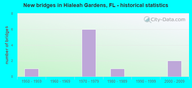
- New bridges - historical statistics
- 11950-1959
- 61970-1979
- 11980-1989
- 22000-2009


- Bridge Condition - Deck
- 14.3%Very good
- 85.7%Good

- Bridge Condition - Superstructure
- 14.3%Very good
- 85.7%Good

- Bridge Condition - Substructure
- 28.6%Very good
- 71.4%Good

- Bridge Condition - Channel
- 87.5%Good
- 12.5%Satisfactory
Find on map >> Show street view
Structure Number: 870225, Location: 22.3 MILES NORTH OF US-1 (Lat: 25.900567, Lng: -80.385661), Route carried "on" structure: State highway 821, Year Built: 1973, Year Reconstructed: 2001, Status: Open, Structure Length: 12.83m (42.09ft), Average Daily Traffic: 44,600 (year 2020), Truck Traffic: 8%, Average Future Daily Traffic: 77,381 (year 2042), Design Load: HS 20+Mod, Features Intersected: US 27-SR 25 & MIAMI CANL
Minimum Vertical Clearance: 30+ m (98+ ft), Kilometerpoint: 56.922, Lanes on structure: 4, Lanes under structure: 6, Base Highway Network: Yes, Toll: On toll road, Owner: State Toll Authority, Approaching Roadway Width: 20.9m (68.6ft), Skew: 2 degrees, Material/Design: Prestressed concrete, Design/Construction: Stringer/Multi-beam, Number Of Spans In Main Unit: 7, Length of Maximum Span: 23.0m (75.5ft), Curb-To-Curb Width: 20.4m (66.9ft), Out-to-Out Width: 21.4m (70.2ft)
Condition: Deck: Good, Superstructure: Good, Substructure: Very good, Channel: Good, Operating Rating: 40.2 metric tons, Method Used To Determine Operating Rating: Load and Resistance Factor (LRFR), Inventory Rating: 31.0 metric tons, Method Used To Determine Inventory Rating: Load and Resistance Factor (LRFR), Structural Evaluation: Better than present minimum criteria, Deck Geometry: Equal to present minimum criteria, Underclear: Somewhat better than minimum adequacy, Waterway Adequacy: Equal to present desirable criteria, Approach Roadway Alignment: Equal to present desirable criteria, Designated Inspection Frequency: Every 24 months, Underwater Inspection Frequency: Every 24 months, Inspection Date: April 2020, Underwater Inspection Date: April 2020, Deck Structure Type: Concrete Cast-file-Place
Find on map >> Show street view
Structure Number: 870226, Location: 24.3 MILES NORTH OF US-1 (Lat: 25.927872, Lng: -80.375511), Route carried "on" structure: State highway 821, Year Built: 1973, Year Reconstructed: 2001, Status: Open, Structure Length: 3.75m (12.30ft), Average Daily Traffic: 44,600 (year 2020), Truck Traffic: 8%, Average Future Daily Traffic: 77,381 (year 2042), Design Load: HS 20+Mod, Features Intersected: GOLDEN GLADES CANAL
Minimum Vertical Clearance: 30+ m (98+ ft), Kilometerpoint: 60.173, Lanes on structure: 3, Base Highway Network: Yes, Toll: On toll road, Owner: State Toll Authority, Approaching Roadway Width: 18.2m (59.7ft), Skew: 2 degrees, Material/Design: Prestressed concrete, Design/Construction: Stringer/Multi-beam, Number Of Spans In Main Unit: 3, Length of Maximum Span: 12.5m (41.0ft), Curb-To-Curb Width: 17.7m (58.1ft), Out-to-Out Width: 18.6m (61.0ft)
Condition: Deck: Good, Superstructure: Good, Substructure: Good, Channel: Good, Operating Rating: 46.7 metric tons, Method Used To Determine Operating Rating: Load and Resistance Factor (LRFR), Inventory Rating: 36.3 metric tons, Method Used To Determine Inventory Rating: Load and Resistance Factor (LRFR), Structural Evaluation: Better than present minimum criteria, Deck Geometry: Better than present minimum criteria, Waterway Adequacy: Equal to present desirable criteria, Approach Roadway Alignment: Equal to present desirable criteria, Designated Inspection Frequency: Every 24 months, Inspection Date: April 2020, Deck Structure Type: Concrete Cast-file-Place
Find on map >> Show street view
Structure Number: 870425, Location: 22.3 MILES NORTH OF US-1 (Lat: 25.900411, Lng: -80.385433), Route carried "on" structure: State highway 821, Year Built: 1973, Year Reconstructed: 2001, Status: Open, Structure Length: 12.83m (42.09ft), Average Daily Traffic: 44,600 (year 2020), Truck Traffic: 8%, Average Future Daily Traffic: 77,381 (year 2042), Design Load: HS 20+Mod, Features Intersected: SR 25 & MIAMI CANAL
Minimum Vertical Clearance: 30.45m (99.90ft), Kilometerpoint: 56.914, Lanes on structure: 4, Lanes under structure: 6, Base Highway Network: Yes, Toll: On toll road, Owner: State Toll Authority, Approaching Roadway Width: 20.7m (67.9ft), Skew: 2 degrees, Material/Design: Prestressed concrete, Design/Construction: Stringer/Multi-beam, Number Of Spans In Main Unit: 7, Length of Maximum Span: 23.0m (75.5ft), Curb-To-Curb Width: 20.4m (66.9ft), Out-to-Out Width: 21.4m (70.2ft)
Condition: Deck: Good, Superstructure: Good, Substructure: Very good, Channel: Good, Operating Rating: 39.8 metric tons, Method Used To Determine Operating Rating: Load and Resistance Factor (LRFR), Inventory Rating: 30.7 metric tons, Method Used To Determine Inventory Rating: Load and Resistance Factor (LRFR), Structural Evaluation: Better than present minimum criteria, Deck Geometry: Equal to present minimum criteria, Underclear: Somewhat better than minimum adequacy, Waterway Adequacy: Equal to present desirable criteria, Approach Roadway Alignment: Equal to present desirable criteria, Designated Inspection Frequency: Every 24 months, Underwater Inspection Frequency: Every 24 months, Inspection Date: April 2020, Underwater Inspection Date: April 2020, Deck Structure Type: Concrete Cast-file-Place
Find on map >> Show street view
Structure Number: 870426, Location: 24.3 MILES NORTH OF US-1 (Lat: 25.927875, Lng: -80.375150), Route carried "on" structure: State highway 821, Year Built: 1973, Year Reconstructed: 2001, Status: Open, Structure Length: 3.88m (12.73ft), Average Daily Traffic: 44,600 (year 2020), Truck Traffic: 8%, Average Future Daily Traffic: 77,381 (year 2042), Design Load: HS 20+Mod, Features Intersected: GOLDEN GLADES CANAL
Minimum Vertical Clearance: 30+ m (98+ ft), Kilometerpoint: 60.178, Lanes on structure: 3, Base Highway Network: Yes, Toll: On toll road, Owner: State Toll Authority, Approaching Roadway Width: 17.3m (56.8ft), Skew: 2 degrees, Material/Design: Prestressed concrete, Design/Construction: Stringer/Multi-beam, Number Of Spans In Main Unit: 3, Length of Maximum Span: 12.9m (42.3ft), Curb-To-Curb Width: 16.8m (55.1ft), Out-to-Out Width: 17.7m (58.1ft)
Condition: Deck: Good, Superstructure: Good, Substructure: Good, Channel: Good, Operating Rating: 58.8 metric tons, Method Used To Determine Operating Rating: Load and Resistance Factor (LRFR), Inventory Rating: 45.4 metric tons, Method Used To Determine Inventory Rating: Load and Resistance Factor (LRFR), Structural Evaluation: Better than present minimum criteria, Deck Geometry: Equal to present minimum criteria, Waterway Adequacy: Equal to present desirable criteria, Approach Roadway Alignment: Equal to present desirable criteria, Designated Inspection Frequency: Every 24 months, Inspection Date: April 2020, Deck Structure Type: Concrete Cast-file-Place
Find on map >> Show street view
Structure Number: 870569, Location: N OF NW 103RD ST. (Lat: 25.869578, Lng: -80.323525), Route carried "on" structure: ServiceOther road 826, Year Built: 1959, Status: Open, Structure Length: 2.73m (8.96ft), Average Daily Traffic: 7,607 (year 2014), Average Future Daily Traffic: 13,198 (year 2036), Design Load: HS 20, Features Intersected: LITTLE RIVER CANAL C-7, Facility Carried by Structure: WEST FRONTAGE RD.
Minimum Vertical Clearance: 30+ m (98+ ft), Kilometerpoint: 0.357, Lanes on structure: 2, Owner: State Highway Agency, Approaching Roadway Width: 8.2m (26.9ft), Material/Design: Concrete, Design/Construction: Slab, Number Of Spans In Main Unit: 3, Length of Maximum Span: 9.1m (29.9ft), Curb or Sidewalk Widths: Left: 0.5m (1.6ft), Right: 0.5m (1.6ft), Curb-To-Curb Width: 8.7m (28.5ft), Out-to-Out Width: 10.4m (34.1ft)
Condition: Deck: Good, Superstructure: Good, Substructure: Good, Channel: Good, Operating Rating: 54.6 metric tons, Method Used To Determine Operating Rating: Load Factor (LF), Inventory Rating: 32.7 metric tons, Method Used To Determine Inventory Rating: Load Factor (LF), Structural Evaluation: Better than present minimum criteria, Deck Geometry: High priority of replacement, Waterway Adequacy: Equal to present minimum criteria, Approach Roadway Alignment: Equal to present desirable criteria, Designated Inspection Frequency: Every 24 months, Underwater Inspection Frequency: Every 24 months, Inspection Date: March 2020, Underwater Inspection Date: March 2020, Deck Structure Type: Concrete Cast-file-Place
Find on map >> Show street view
Structure Number: 870755, Location: 0.1M N OF SR 932 (Lat: 25.869611, Lng: -80.323294), Route carried "on" structure: Ramp Other road 826, Year Built: 2002, Status: Open, Structure Length: 2.58m (8.46ft), Average Daily Traffic: 17,000 (year 2020), Truck Traffic: 5%, Average Future Daily Traffic: 29,495 (year 2042), Design Load: HS 20, Features Intersected: LITTLE RIVER CANAL
Minimum Vertical Clearance: 30.18m (99.02ft), Kilometerpoint: 0.014, Lanes on structure: 2, Base Highway Network: Yes, Owner: State Highway Agency, Approaching Roadway Width: 11.2m (36.7ft), Material/Design: Prestressed concrete, Design/Construction: Stringer/Multi-beam, Number Of Spans In Main Unit: 1, Length of Maximum Span: 25.8m (84.6ft), Curb-To-Curb Width: 11.2m (36.7ft), Out-to-Out Width: 17.2m (56.4ft)
Condition: Deck: Good, Superstructure: Good, Substructure: Good, Channel: Good, Operating Rating: 46.7 metric tons, Method Used To Determine Operating Rating: Load and Resistance Factor (LRFR), Inventory Rating: 42.8 metric tons, Method Used To Determine Inventory Rating: Load and Resistance Factor (LRFR), Structural Evaluation: Better than present minimum criteria, Deck Geometry: Superior to present desirable criteria, Waterway Adequacy: Meets minimum limits, Approach Roadway Alignment: Equal to present desirable criteria, Designated Inspection Frequency: Every 24 months, Underwater Inspection Frequency: Every 24 months, Inspection Date: May 2021, Underwater Inspection Date: May 2021, Deck Structure Type: Concrete Cast-file-Place
Find on map >> Show street view
Structure Number: 874098, Location: 50 ft N of NW 103rd St. (Lat: 25.869589, Lng: -80.331056), Route carried "on" structure: County highway , Year Built: 1983, Status: Open, Structure Length: 0.78m (2.56ft), Average Daily Traffic: 4,621 (year 2020), Truck Traffic: 2%, Average Future Daily Traffic: 7,433 (year 2042), Design Load: HS 20, Features Intersected: Little River Canal, Facility Carried by Structure: NW 82 Ave/W 24 Ave
Minimum Vertical Clearance: 30+ m (98+ ft), Kilometerpoint: 0.026, Lanes on structure: 5, Owner: City or Municipal Highway Agency, Approaching Roadway Width: 17.6m (57.7ft), Material/Design: Aluminum, Iron, Design/Construction: Culvert, Number Of Spans In Main Unit: 1, Length of Maximum Span: 7.8m (25.6ft), Curb or Sidewalk Widths: Left: 2.1m (6.9ft), Right: 2.1m (6.9ft)
Condition: Channel: Good, Culverts: Satisfactory, Operating Rating: 86.3 metric tons, Method Used To Determine Operating Rating: Load Factor (LF), Inventory Rating: 60.7 metric tons, Method Used To Determine Inventory Rating: Load Factor (LF), Structural Evaluation: Equal to present minimum criteria, Waterway Adequacy: Equal to present desirable criteria, Approach Roadway Alignment: Equal to present desirable criteria, Designated Inspection Frequency: Every 24 months, Underwater Inspection Frequency: Every 24 months, Inspection Date: October 2020, Underwater Inspection Date: October 2020
Find on map >> Show street view
Structure Number: 87418, Location: At US-27 (Okeechobee Rd.) (Lat: 25.890372, Lng: -80.372081), Route carried "on" structure: City street , Year Built: 2004, Status: Open, Structure Length: 4.27m (14.01ft), Average Daily Traffic: 6,000 (year 2014), Truck Traffic: 30%, Average Future Daily Traffic: 7,200 (year 2036), Design Load: HS 25 or greater, Features Intersected: Miami Canal, Facility Carried by Structure: NW 107th Avenue
Minimum Vertical Clearance: 30+ m (98+ ft), Kilometerpoint: 0.663, Lanes on structure: 2, Owner: County Highway Agency, Approaching Roadway Width: 7.5m (24.6ft), Skew: 4 degrees, Material/Design: Prestressed concrete, Design/Construction: Stringer/Multi-beam, Number Of Spans In Main Unit: 3, Length of Maximum Span: 14.2m (46.6ft), Curb or Sidewalk Widths: Left: 1.7m (5.6ft), Right: 0.0m, Curb-To-Curb Width: 12.0m (39.4ft), Out-to-Out Width: 14.5m (47.6ft)
Condition: Deck: Very good, Superstructure: Very good, Substructure: Good, Channel: Satisfactory, Operating Rating: 57.8 metric tons, Method Used To Determine Operating Rating: Load Factor (LF), Inventory Rating: 34.7 metric tons, Method Used To Determine Inventory Rating: Load Factor (LF), Structural Evaluation: Better than present minimum criteria, Deck Geometry: Somewhat better than minimum adequacy, Waterway Adequacy: Better than present minimum criteria, Approach Roadway Alignment: Equal to present minimum criteria, Designated Inspection Frequency: Every 24 months, Underwater Inspection Frequency: Every 24 months, Inspection Date: March 2020, Underwater Inspection Date: March 2020, Deck Structure Type: Concrete Cast-file-Place, Wearing Surface/Protective System: Wearing Surface: Monolithic Concrete
Find on map >> Show street view
Structure Number: 870225, Location: 22.3 MILES NORTH OF US-1 (Lat: 25.900567, Lng: -80.385661), Route carried "under" structure: US 27, Year Built: 1973, Structure Length: 0. m, Average Daily Traffic: 28,500 (year 2020), Truck Traffic: 24%, Features Intersected: US 27-SR 25 & MIAMI CANL, Facility Carried by Structure: SR821 HEFT SB 35.2
Minimum Vertical Clearance: 5.03m (16.50ft), Kilometerpoint: 8.280, Lanes on structure: 4, Lanes under structure: 5, Material/Design: Prestressed concrete, Design/Construction: Stringer/Multi-beam, Length of Maximum Span: 23.0m (75.5ft)
Find on map >> Show street view
Structure Number: 870425, Location: 22.3 MILES NORTH OF US-1 (Lat: 25.900411, Lng: -80.385433), Route carried "under" structure: US 27, Year Built: 1973, Structure Length: 0. m, Average Daily Traffic: 22,500 (year 2020), Truck Traffic: 33%, Features Intersected: SR 25 & MIAMI CANAL, Facility Carried by Structure: SR821 HEFT NB 35.2
Minimum Vertical Clearance: 5.03m (16.50ft), Kilometerpoint: 8.309, Lanes on structure: 4, Lanes under structure: 5, Material/Design: Prestressed concrete, Design/Construction: Stringer/Multi-beam, Length of Maximum Span: 23.0m (75.5ft)