Bridge Statistics for Hazelwood, Missouri (MO)
Condition, Traffic, Stress, Structural Evaluation, Project Costs
- National Bridge Inventory (NBI) Statistics
- 42Number of bridges
- 486ft / 148mTotal length
- $6,942,000Total costs
- 1,320,023Total average daily traffic
- 207,560Total average daily truck traffic
- National Bridge Inventory (NBI) Registered Bridges for Hazelwood
- No street view available for this location
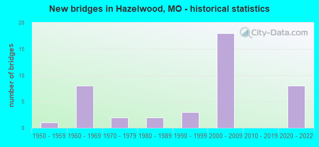
- New bridges - historical statistics
- 11950-1959
- 81960-1969
- 21970-1979
- 21980-1989
- 31990-1999
- 182000-2009
- 82020-2022

- Reconstructed bridges - Historical Statistics
- 11980-1989
- 21990-1999


- Bridge Condition - Deck
- 14.3%Excellent
- 7.1%Very good
- 28.6%Good
- 28.6%Satisfactory
- 21.4%Fair

- Bridge Condition - Superstructure
- 21.4%Excellent
- 14.3%Very good
- 21.4%Good
- 7.1%Satisfactory
- 35.7%Fair

- Bridge Condition - Substructure
- 21.4%Excellent
- 14.3%Very good
- 21.4%Good
- 21.4%Satisfactory
- 7.1%Fair
- 14.3%Poor

- Bridge Condition - Channel
- 28.6%Good
- 28.6%Satisfactory
- 42.9%Fair

- Bridge Condition - Culverts
- 75.0%Satisfactory
- 25.0%Fair
Find on map >> Show street view
Structure Number: 15533, Location: S 36 T 47 N R 6 E (Lat: 38.779533, Lng: -90.406942), Route carried "on" structure: County highway , Year Built: 1962, Status: Posted for load, Structure Length: 1.04m (3.41ft), Average Daily Traffic: 1,463 (year 2020), Truck Traffic: 2%, Average Future Daily Traffic: 1,975 (year 2040), Design Load: HS 20, Features Intersected: BR OF COWMIRE CR, Facility Carried by Structure: DUNN RD
Minimum Vertical Clearance: 30+ m (98+ ft), Kilometerpoint: 1.770, Lanes on structure: 2, Owner: County Highway Agency, Approaching Roadway Width: 7.3m (24.0ft), Material/Design: Concrete, Design/Construction: Slab, Number Of Spans In Main Unit: 1, Length of Maximum Span: 9.1m (29.9ft), Curb-To-Curb Width: 7.1m (23.3ft), Out-to-Out Width: 7.5m (24.6ft)
Condition: Deck: Fair, Superstructure: Fair, Substructure: Poor, Channel: Fair, Operating Rating: 35.1 metric tons, Method Used To Determine Operating Rating: Allowable Stress (AS), Inventory Rating: 22.5 metric tons, Method Used To Determine Inventory Rating: Allowable Stress (AS), Structural Evaluation: Meets minimum limits, Deck Geometry: High priority of corrective action, Waterway Adequacy: Equal to present minimum criteria, Approach Roadway Alignment: Equal to present desirable criteria, Length Of Structure Improvement: 0.17m (0.56ft), Designated Inspection Frequency: Every 24 months, Inspection Date: April 2021, Bridge Improvement Cost: $185,000, Roadway Improvement Cost: $18,000, Total Project Cost: $277,000 ( Estimate for 2022), Deck Structure Type: Concrete Cast-file-Place, Wearing Surface/Protective System: Wearing Surface: Bituminous
Find on map >> Show street view
Structure Number: 15538, Location: S 24 T 46 N R 7 E (Lat: 38.800253, Lng: -90.411478), Route carried "on" structure: County highway , Year Built: 1964, Status: Posted for load, Structure Length: 1.43m (4.69ft), Average Daily Traffic: 8,094 (year 2020), Truck Traffic: 5%, Average Future Daily Traffic: 10,927 (year 2040), Design Load: HS 20, Features Intersected: COWMIRE CR, Facility Carried by Structure: AUBUCHON RD
Minimum Vertical Clearance: 30+ m (98+ ft), Kilometerpoint: 0.000, Lanes on structure: 2, Owner: County Highway Agency, Approaching Roadway Width: 7.0m (23.0ft), Material/Design: Steel, Design/Construction: Stringer/Multi-beam, Number Of Spans In Main Unit: 1, Length of Maximum Span: 13.4m (44.0ft), Curb-To-Curb Width: 7.0m (23.0ft), Out-to-Out Width: 7.3m (24.0ft)
Condition: Deck: Good, Superstructure: Very good, Substructure: Satisfactory, Channel: Good, Operating Rating: 72.0 metric tons, Method Used To Determine Operating Rating: Load Factor (LF), Inventory Rating: 43.2 metric tons, Method Used To Determine Inventory Rating: Load Factor (LF), Structural Evaluation: Equal to present minimum criteria, Deck Geometry: High priority of replacement, Waterway Adequacy: High priority of corrective action, Approach Roadway Alignment: Better than present minimum criteria, Length Of Structure Improvement: 0.21m (0.69ft), Designated Inspection Frequency: Every 24 months, Inspection Date: April 2021, Bridge Improvement Cost: $180,000, Roadway Improvement Cost: $18,000, Total Project Cost: $270,000 ( Estimate for 2022), Deck Structure Type: Concrete Cast-file-Place
Find on map >> Show street view
Structure Number: 15561, Location: S 5 T 46 N R 6 E (Lat: 38.759992, Lng: -90.360778), Route carried "on" structure: County highway , Year Built: 1951, Year Reconstructed: 1989, Status: Posted for load, Structure Length: 3.38m (11.09ft), Average Daily Traffic: 10,699 (year 2020), Truck Traffic: 10%, Average Future Daily Traffic: 14,444 (year 2040), Design Load: HS 20+Mod, Features Intersected: COLDWATER CR, Facility Carried by Structure: JAMES S MCDONNELL
Minimum Vertical Clearance: 30+ m (98+ ft), Kilometerpoint: 0.161, Lanes on structure: 4, Owner: County Highway Agency, Approaching Roadway Width: 15.5m (50.9ft), Material/Design: Steel, Design/Construction: Stringer/Multi-beam, Number Of Spans In Main Unit: 3, Length of Maximum Span: 13.1m (43.0ft), Curb or Sidewalk Widths: Left: 0.2m (0.7ft), Right: 0.2m (0.7ft), Curb-To-Curb Width: 15.5m (50.9ft), Out-to-Out Width: 16.4m (53.8ft)
Condition: Deck: Satisfactory, Superstructure: Satisfactory, Substructure: Poor, Channel: Satisfactory, Operating Rating: 56.7 metric tons, Method Used To Determine Operating Rating: Allowable Stress (AS), Inventory Rating: 31.5 metric tons, Method Used To Determine Inventory Rating: Allowable Stress (AS), Structural Evaluation: Meets minimum limits, Deck Geometry: Meets minimum limits, Waterway Adequacy: Equal to present desirable criteria, Approach Roadway Alignment: Equal to present minimum criteria, Length Of Structure Improvement: 0.43m (1.41ft), Designated Inspection Frequency: Every 24 months, Inspection Date: April 2020, Bridge Improvement Cost: $897,000, Roadway Improvement Cost: $90,000, Total Project Cost: $1,345,000 ( Estimate for 2022), Deck Structure Type: Concrete Cast-file-Place, Wearing Surface/Protective System: Wearing Surface: Monolithic Concrete, Membrane: Other, Deck Protection: Epoxy Coated Reinforcing
Find on map >> Show street view
Structure Number: 18579, Location: S 176 T 47 N R 6 E (Lat: 38.800008, Lng: -90.383100), Route carried "on" structure: City street , Year Built: 1989, Status: Posted for load, Structure Length: 0.64m (2.10ft), Average Daily Traffic: 1,000 (year 2020), Truck Traffic: 1%, Average Future Daily Traffic: 1,350 (year 2040), Features Intersected: TESSON TRIB, Facility Carried by Structure: RIVERWOOD PLACE DR
Minimum Vertical Clearance: 30+ m (98+ ft), Kilometerpoint: 10.139, Lanes on structure: 2, Owner: City or Municipal Highway Agency, Approaching Roadway Width: 7.9m (25.9ft), Skew: 2 degrees, Material/Design: Concrete, Design/Construction: Culvert, Number Of Spans In Main Unit: 2, Length of Maximum Span: 3.0m (9.8ft)
Condition: Channel: Satisfactory, Culverts: Satisfactory, Operating Rating: 89.1 metric tons, Method Used To Determine Operating Rating: Allowable Stress (AS), Inventory Rating: 41.4 metric tons, Method Used To Determine Inventory Rating: Allowable Stress (AS), Structural Evaluation: Equal to present minimum criteria, Waterway Adequacy: Superior to present desirable criteria, Approach Roadway Alignment: Equal to present desirable criteria, Designated Inspection Frequency: Every 24 months, Inspection Date: December 2021
Find on map >> Show street view
Structure Number: 193, Location: S 33 T 47 N R 6 E (Lat: 38.778261, Lng: -90.360061), Route carried "on" structure: US 67, Year Built: 1960, Year Reconstructed: 1990, Status: Posted for load, Structure Length: 8.75m (28.71ft), Average Daily Traffic: 21,799 (year 2021), Truck Traffic: 5%, Average Future Daily Traffic: 30,519 (year 2041), Design Load: HS 20, Features Intersected: IS 270
Minimum Vertical Clearance: 30+ m (98+ ft), Kilometerpoint: 22.632, Lanes on structure: 3, Lanes under structure: 7, Base Highway Network: Yes, Owner: State Highway Agency, Approaching Roadway Width: 14.6m (47.9ft), Material/Design: Concrete continuous, Design/Construction: Slab, Number Of Spans In Main Unit: 5, Length of Maximum Span: 20.7m (67.9ft), Curb-To-Curb Width: 11.2m (36.7ft), Out-to-Out Width: 12.3m (40.4ft)
Condition: Deck: Fair, Superstructure: Fair, Substructure: Satisfactory, Operating Rating: 41.4 metric tons, Method Used To Determine Operating Rating: Load Factor (LF), Inventory Rating: 25.2 metric tons, Method Used To Determine Inventory Rating: Load Factor (LF), Structural Evaluation: Somewhat better than minimum adequacy, Deck Geometry: High priority of replacement, Underclear: High priority of corrective action, Approach Roadway Alignment: Equal to present desirable criteria, Length Of Structure Improvement: 0.97m (3.18ft), Designated Inspection Frequency: Every 24 months, Inspection Date: August 2020, Bridge Improvement Cost: $1,025,000, Roadway Improvement Cost: $102,000, Total Project Cost: $1,537,000 ( Estimate for 2022), Deck Structure Type: Concrete Cast-file-Place, Wearing Surface/Protective System: Wearing Surface: Low Slump Concrete, Membrane: Built-up
Find on map >> Show street view
Structure Number: 194, Location: S 33 T 47 N R 6 E (Lat: 38.778250, Lng: -90.359939), Route carried "on" structure: US 67, Year Built: 1960, Year Reconstructed: 1990, Status: Closed, Structure Length: 8.75m (28.71ft), Average Daily Traffic: 9,151 (year 2021), Truck Traffic: 5%, Average Future Daily Traffic: 12,811 (year 2041), Design Load: HS 20, Features Intersected: IS 270
Minimum Vertical Clearance: 30+ m (98+ ft), Kilometerpoint: 295.446, Lanes on structure: 3, Lanes under structure: 7, Base Highway Network: Yes, Owner: State Highway Agency, Approaching Roadway Width: 14.6m (47.9ft), Material/Design: Concrete continuous, Design/Construction: Slab, Number Of Spans In Main Unit: 5, Length of Maximum Span: 20.7m (67.9ft), Curb-To-Curb Width: 11.2m (36.7ft), Out-to-Out Width: 12.3m (40.4ft)
Condition: Deck: Fair, Superstructure: Fair, Substructure: Satisfactory, Approach Roadway Alignment: Equal to present desirable criteria, Bridge Posting: Required (Relationship of Operating Rating to Maximum Legal Load: > 39.9% below), Length Of Structure Improvement: 0.97m (3.18ft), Designated Inspection Frequency: Every 24 months, Inspection Date: August 2020, Bridge Improvement Cost: $1,507,000, Roadway Improvement Cost: $151,000, Total Project Cost: $2,261,000 ( Estimate for 2022), Deck Structure Type: Concrete Cast-file-Place, Wearing Surface/Protective System: Wearing Surface: Low Slump Concrete
Find on map >> Show street view
Structure Number: 28386, Location: S 23 T 47 N R 5 E (Lat: 38.797494, Lng: -90.418417), Route carried "on" structure: County highway , Year Built: 1999, Status: Closed, Structure Length: 0.79m (2.59ft), Average Daily Traffic: 12,454 (year 2020), Truck Traffic: 5%, Average Future Daily Traffic: 16,813 (year 2040), Design Load: HS 20, Features Intersected: BR OF COWMIRE CR, Facility Carried by Structure: AUBUCHON RD
Minimum Vertical Clearance: 30+ m (98+ ft), Kilometerpoint: 0.000, Lanes on structure: 2, Owner: County Highway Agency, Approaching Roadway Width: 6.4m (21.0ft), Material/Design: Aluminum, Iron, Design/Construction: Culvert, Number Of Spans In Main Unit: 3, Length of Maximum Span: 2.4m (7.9ft), Curb-To-Curb Width: 7.6m (24.9ft), Out-to-Out Width: 7.9m (25.9ft)
Condition: Channel: Fair, Culverts: Fair, Waterway Adequacy: Meets minimum limits, Approach Roadway Alignment: Equal to present desirable criteria, Length Of Structure Improvement: 0.14m (0.46ft), Designated Inspection Frequency: Every 24 months, Inspection Date: April 2021, Bridge Improvement Cost: $125,000, Roadway Improvement Cost: $13,000, Total Project Cost: $188,000 ( Estimate for 2022)
Find on map >> Show street view
Structure Number: 29117, Location: S 278 T 47 N R 3 E (Lat: 38.777814, Lng: -90.389267), Route carried "on" structure: City street , Year Built: 2002, Status: Open, Structure Length: 5.88m (19.29ft), Average Daily Traffic: 20,940 (year 2021), Truck Traffic: 5%, Average Future Daily Traffic: 29,316 (year 2041), Design Load: HS 25 or greater, Features Intersected: IS 270, Facility Carried by Structure: JAMES S MCDONNELL
Minimum Vertical Clearance: 30+ m (98+ ft), Kilometerpoint: 0.309, Lanes on structure: 9, Lanes under structure: 8, Base Highway Network: Yes, Owner: State Highway Agency, Approaching Roadway Width: 11.9m (39.0ft), Material/Design: Steel continuous, Design/Construction: Stringer/Multi-beam, Number Of Spans In Main Unit: 2, Length of Maximum Span: 29.4m (96.5ft), Curb-To-Curb Width: 40.4m (132.5ft), Out-to-Out Width: 41.2m (135.2ft)
Condition: Deck: Satisfactory, Superstructure: Good, Substructure: Good, Operating Rating: 81.0 metric tons, Method Used To Determine Operating Rating: Load Factor (LF), Inventory Rating: 48.6 metric tons, Method Used To Determine Inventory Rating: Load Factor (LF), Structural Evaluation: Better than present minimum criteria, Deck Geometry: Superior to present desirable criteria, Underclear: Equal to present minimum criteria, Approach Roadway Alignment: Equal to present desirable criteria, Designated Inspection Frequency: Every 24 months, Inspection Date: August 2020, Deck Structure Type: Concrete Cast-file-Place, Wearing Surface/Protective System: Wearing Surface: Epoxy Overlay, Deck Protection: Epoxy Coated Reinforcing
Find on map >> Show street view
Structure Number: 29143, Location: S 939 T 47 N R 6 E (Lat: 38.775456, Lng: -90.340744), Route carried "on" structure: Interstate 170, Year Built: 2002, Status: Open, Structure Length: 47.49m (155.81ft), Average Daily Traffic: 31,358 (year 2021), Truck Traffic: 18%, Average Future Daily Traffic: 39,198 (year 2041), Design Load: HS 25 or greater, Features Intersected: IS 270, RP DUNN RD TO IS
Minimum Vertical Clearance: 5.31m (17.42ft), Kilometerpoint: 17.449, Lanes on structure: 1, Lanes under structure: 12, Base Highway Network: Yes, Owner: State Highway Agency, Approaching Roadway Width: 8.5m (27.9ft), Skew: 3 degrees, Material/Design: Steel continuous, Design/Construction: Stringer/Multi-beam, Number Of Spans In Main Unit: 4, Number Of Approach Spans: 11, Length of Maximum Span: 55.9m (183.4ft), Curb-To-Curb Width: 8.5m (27.9ft), Out-to-Out Width: 9.3m (30.5ft)
Condition: Deck: Satisfactory, Superstructure: Fair, Substructure: Good, Operating Rating: 60.3 metric tons, Method Used To Determine Operating Rating: Load Factor (LF), Inventory Rating: 36.0 metric tons, Method Used To Determine Inventory Rating: Load Factor (LF), Structural Evaluation: Somewhat better than minimum adequacy, Deck Geometry: Meets minimum limits, Underclear: Equal to present minimum criteria, Approach Roadway Alignment: Equal to present desirable criteria, Designated Inspection Frequency: Every 24 months, Inspection Date: September 2020, Deck Structure Type: Concrete Cast-file-Place, Wearing Surface/Protective System: Wearing Surface: Monolithic Concrete, Deck Protection: Epoxy Coated Reinforcing
Find on map >> Show street view
Structure Number: 29167, Location: S 939 T 47 N R 6 E (Lat: 38.775186, Lng: -90.340411), Route carried "on" structure: Ramp State highway , Year Built: 2002, Status: Open, Structure Length: 32.77m (107.51ft), Average Daily Traffic: 20,232 (year 2021), Truck Traffic: 10%, Average Future Daily Traffic: 25,290 (year 2041), Design Load: HS 20, Features Intersected: IS 270, IS 170, OR 270,, Facility Carried by Structure: RP IS270W TO IS170
Minimum Vertical Clearance: 30+ m (98+ ft), Kilometerpoint: 0.394, Lanes on structure: 1, Lanes under structure: 10, Base Highway Network: Yes, Owner: State Highway Agency, Approaching Roadway Width: 12.2m (40.0ft), Skew: 2 degrees, Material/Design: Steel continuous, Design/Construction: Stringer/Multi-beam, Number Of Spans In Main Unit: 5, Number Of Approach Spans: 5, Length of Maximum Span: 46.6m (152.9ft), Curb-To-Curb Width: 12.2m (40.0ft), Out-to-Out Width: 13.0m (42.7ft)
Condition: Deck: Satisfactory, Superstructure: Excellent, Substructure: Very good, Operating Rating: 73.8 metric tons, Method Used To Determine Operating Rating: Load Factor (LF), Inventory Rating: 44.1 metric tons, Method Used To Determine Inventory Rating: Load Factor (LF), Structural Evaluation: Equal to present desirable criteria, Deck Geometry: Superior to present desirable criteria, Underclear: High priority of corrective action, Approach Roadway Alignment: Equal to present desirable criteria, Designated Inspection Frequency: Every 24 months, Inspection Date: September 2021, Deck Structure Type: Concrete Cast-file-Place, Wearing Surface/Protective System: Wearing Surface: Monolithic Concrete, Deck Protection: Epoxy Coated Reinforcing
Find on map >> Show street view
Structure Number: 29201, Location: S 939 T 47 N R 6 E (Lat: 38.774328, Lng: -90.339894), Route carried "on" structure: Ramp State highway , Year Built: 2002, Status: Open, Structure Length: 7.47m (24.51ft), Average Daily Traffic: 21,728 (year 2021), Truck Traffic: 18%, Average Future Daily Traffic: 27,160 (year 2041), Design Load: HS 25 or greater, Features Intersected: OR 270, Facility Carried by Structure: RP IS170W TO IS270
Minimum Vertical Clearance: 30+ m (98+ ft), Kilometerpoint: 0.024, Lanes on structure: 2, Lanes under structure: 2, Base Highway Network: Yes, Owner: State Highway Agency, Approaching Roadway Width: 12.2m (40.0ft), Skew: 4 degrees, Material/Design: Prestressed concrete continuous, Design/Construction: Stringer/Multi-beam, Number Of Spans In Main Unit: 3, Length of Maximum Span: 27.4m (89.9ft), Curb-To-Curb Width: 12.2m (40.0ft), Out-to-Out Width: 13.0m (42.7ft)
Condition: Deck: Good, Superstructure: Good, Substructure: Very good, Operating Rating: 57.6 metric tons, Method Used To Determine Operating Rating: Load Factor (LF), Inventory Rating: 35.1 metric tons, Method Used To Determine Inventory Rating: Load Factor (LF), Structural Evaluation: Better than present minimum criteria, Deck Geometry: Superior to present desirable criteria, Underclear: Superior to present desirable criteria, Approach Roadway Alignment: Better than present minimum criteria, Designated Inspection Frequency: Every 24 months, Inspection Date: September 2020, Deck Structure Type: Concrete Cast-file-Place, Wearing Surface/Protective System: Wearing Surface: Monolithic Concrete, Deck Protection: Epoxy Coated Reinforcing
Find on map >> Show street view
Structure Number: 29204, Location: S 939 T 47 N R 6 E (Lat: 38.775175, Lng: -90.338433), Route carried "on" structure: Ramp State highway , Year Built: 2002, Status: Open, Structure Length: 7.89m (25.89ft), Average Daily Traffic: 21,728 (year 2021), Truck Traffic: 18%, Average Future Daily Traffic: 27,160 (year 2041), Design Load: HS 20+Mod, Features Intersected: RP IS270E TO NORTH HANLE, Facility Carried by Structure: RP IS170W TO IS270
Minimum Vertical Clearance: 30+ m (98+ ft), Kilometerpoint: 0.225, Lanes on structure: 2, Lanes under structure: 1, Base Highway Network: Yes, Owner: State Highway Agency, Approaching Roadway Width: 12.2m (40.0ft), Material/Design: Steel continuous, Design/Construction: Stringer/Multi-beam, Number Of Spans In Main Unit: 2, Length of Maximum Span: 45.1m (148.0ft), Curb-To-Curb Width: 12.2m (40.0ft), Out-to-Out Width: 13.0m (42.7ft)
Condition: Deck: Good, Superstructure: Very good, Substructure: Good, Inventory Rating: 70.2 metric tons, Method Used To Determine Inventory Rating: Load Factor (LF), Structural Evaluation: Better than present minimum criteria, Deck Geometry: Superior to present desirable criteria, Underclear: Better than present minimum criteria, Approach Roadway Alignment: Equal to present desirable criteria, Designated Inspection Frequency: Every 24 months, Critical Feature Inspection Frequency: Every 24 months, Inspection Date: September 2021, Critical Feature Inspection Date: September 2021, Deck Structure Type: Concrete Cast-file-Place, Wearing Surface/Protective System: Wearing Surface: Monolithic Concrete, Deck Protection: Epoxy Coated Reinforcing
Find on map >> Show street view
Structure Number: 30102, Location: S 24 T 47 N R 5 E (Lat: 38.811111, Lng: -90.391275), Route carried "on" structure: County highway , Year Built: 2003, Status: Posted for load, Structure Length: 1.52m (4.99ft), Average Daily Traffic: 6,246 (year 2020), Truck Traffic: 10%, Average Future Daily Traffic: 8,432 (year 2040), Design Load: HS 25 or greater, Features Intersected: BR OF COWMIRE CR, Facility Carried by Structure: CHARBONIER RD
Minimum Vertical Clearance: 30+ m (98+ ft), Kilometerpoint: 0.000, Lanes on structure: 2, Owner: County Highway Agency, Approaching Roadway Width: 12.2m (40.0ft), Material/Design: Concrete continuous, Design/Construction: Culvert, Number Of Spans In Main Unit: 3, Length of Maximum Span: 4.9m (16.1ft), Curb-To-Curb Width: 12.2m (40.0ft), Out-to-Out Width: 12.2m (40.0ft)
Condition: Channel: Fair, Culverts: Satisfactory, Operating Rating: 89.1 metric tons, Method Used To Determine Operating Rating: Load Factor (LF), Inventory Rating: 58.5 metric tons, Method Used To Determine Inventory Rating: Load Factor (LF), Structural Evaluation: Equal to present minimum criteria, Deck Geometry: Somewhat better than minimum adequacy, Waterway Adequacy: Superior to present desirable criteria, Approach Roadway Alignment: Equal to present desirable criteria, Designated Inspection Frequency: Every 24 months, Inspection Date: April 2021
Find on map >> Show street view
Structure Number: 3161, Location: S 939 T 47 N R 6 E (Lat: 38.774267, Lng: -90.341417), Route carried "on" structure: Interstate 170, Year Built: 1978, Status: Open, Structure Length: 7.64m (25.07ft), Average Daily Traffic: 13,932 (year 2021), Truck Traffic: 18%, Average Future Daily Traffic: 17,415 (year 2041), Design Load: HS 20, Features Intersected: OR 270
Minimum Vertical Clearance: 30+ m (98+ ft), Kilometerpoint: 0.343, Lanes on structure: 1, Lanes under structure: 2, Base Highway Network: Yes, Owner: State Highway Agency, Approaching Roadway Width: 7.6m (24.9ft), Skew: 4 degrees, Material/Design: Prestressed concrete continuous, Design/Construction: Stringer/Multi-beam, Number Of Spans In Main Unit: 5, Length of Maximum Span: 22.8m (74.8ft), Curb-To-Curb Width: 7.6m (24.9ft), Out-to-Out Width: 8.6m (28.2ft)
Condition: Deck: Good, Superstructure: Fair, Substructure: Fair, Operating Rating: 76.5 metric tons, Method Used To Determine Operating Rating: Load Factor (LF), Inventory Rating: 32.4 metric tons, Method Used To Determine Inventory Rating: Load Factor (LF), Structural Evaluation: Somewhat better than minimum adequacy, Deck Geometry: High priority of replacement, Underclear: Equal to present desirable criteria, Approach Roadway Alignment: Better than present minimum criteria, Length Of Structure Improvement: 0.87m (2.85ft), Designated Inspection Frequency: Every 24 months, Inspection Date: September 2020, Bridge Improvement Cost: $709,000, Roadway Improvement Cost: $71,000, Total Project Cost: $1,064,000 ( Estimate for 2022), Deck Structure Type: Concrete Cast-file-Place, Wearing Surface/Protective System: Wearing Surface: Other
Find on map >> Show street view
Structure Number: 36405, Location: S 33 T 47 N R 6 W (Lat: 38.779589, Lng: -90.359581), Route carried "on" structure: US 67, Year Built: 2020, Status: Open, Structure Length: 2.13m (6.99ft), Average Daily Traffic: 21,212 (year 2021), Truck Traffic: 5%, Average Future Daily Traffic: 29,697 (year 2041), Features Intersected: OR 270
Minimum Vertical Clearance: 30+ m (98+ ft), Kilometerpoint: 295.613, Lanes on structure: 4, Lanes under structure: 2, Base Highway Network: Yes, Owner: State Highway Agency, Approaching Roadway Width: 18.0m (59.1ft), Skew: 2 degrees, Material/Design: Prestressed concrete, Design/Construction: Tee Beam, Number Of Spans In Main Unit: 1, Length of Maximum Span: 20.1m (65.9ft), Curb-To-Curb Width: 18.0m (59.1ft), Out-to-Out Width: 18.8m (61.7ft)
Condition: Deck: Very good, Superstructure: Good, Substructure: Excellent, Operating Rating: 90.0 metric tons, Method Used To Determine Operating Rating: Load Factor (LF), Inventory Rating: 47.7 metric tons, Method Used To Determine Inventory Rating: Load Factor (LF), Structural Evaluation: Better than present minimum criteria, Deck Geometry: Somewhat better than minimum adequacy, Underclear: Somewhat better than minimum adequacy, Approach Roadway Alignment: Equal to present desirable criteria, Designated Inspection Frequency: Every 24 months, Inspection Date: June 2021, Deck Structure Type: Concrete Cast-file-Place, Wearing Surface/Protective System: Wearing Surface: Monolithic Concrete, Deck Protection: Epoxy Coated Reinforcing
Find on map >> Show street view
Structure Number: 36408, Location: S 33 T 47 N R 6 E (Lat: 38.778250, Lng: -90.359939), Route carried "on" structure: US 67, Year Built: 2020, Status: Open, Structure Length: 4.92m (16.14ft), Average Daily Traffic: 9,151 (year 2021), Truck Traffic: 5%, Average Future Daily Traffic: 12,811 (year 2041), Features Intersected: IS 270
Minimum Vertical Clearance: 30+ m (98+ ft), Kilometerpoint: 295.449, Lanes on structure: 3, Lanes under structure: 8, Base Highway Network: Yes, Owner: State Highway Agency, Approaching Roadway Width: 13.7m (44.9ft), Material/Design: Prestressed concrete, Design/Construction: Tee Beam, Number Of Spans In Main Unit: 1, Length of Maximum Span: 48.2m (158.1ft), Curb-To-Curb Width: 13.7m (44.9ft), Out-to-Out Width: 14.5m (47.6ft)
Condition: Deck: Excellent, Superstructure: Excellent, Substructure: Excellent, Inventory Rating: 33.3 metric tons, Method Used To Determine Inventory Rating: Load Factor (LF), Structural Evaluation: Superior to present desirable criteria, Deck Geometry: Somewhat better than minimum adequacy, Underclear: Equal to present minimum criteria, Approach Roadway Alignment: Equal to present desirable criteria, Designated Inspection Frequency: Every 24 months, Inspection Date: June 2021, Deck Structure Type: Concrete Cast-file-Place, Wearing Surface/Protective System: Wearing Surface: Monolithic Concrete, Deck Protection: Epoxy Coated Reinforcing
Find on map >> Show street view
Structure Number: 36423, Location: S 33 T 47 N R 6 E (Lat: 38.778261, Lng: -90.360061), Route carried "on" structure: US 67, Year Built: 2020, Status: Not yet open, Structure Length: 4.86m (15.94ft), Average Daily Traffic: 21,799 (year 2021), Truck Traffic: 5%, Average Future Daily Traffic: 30,519 (year 2041), Features Intersected: IS 270
Minimum Vertical Clearance: 5.03m (16.50ft), Kilometerpoint: 22.655, Lanes on structure: 4, Lanes under structure: 8, Base Highway Network: Yes, Owner: State Highway Agency, Approaching Roadway Width: 17.1m (56.1ft), Material/Design: Prestressed concrete, Design/Construction: Tee Beam, Number Of Spans In Main Unit: 1, Length of Maximum Span: 47.6m (156.2ft), Curb or Sidewalk Widths: Left: 1.5m (4.9ft), Right: 0.0m, Curb-To-Curb Width: 17.1m (56.1ft), Out-to-Out Width: 19.7m (64.6ft)
Condition: Deck: Excellent, Superstructure: Excellent, Substructure: Excellent, Operating Rating: 67.5 metric tons, Method Used To Determine Operating Rating: Load Factor (LF), Inventory Rating: 40.5 metric tons, Method Used To Determine Inventory Rating: Load Factor (LF), Structural Evaluation: Superior to present desirable criteria, Deck Geometry: Somewhat better than minimum adequacy, Underclear: Somewhat better than minimum adequacy, Approach Roadway Alignment: Equal to present desirable criteria, Designated Inspection Frequency: Every 24 months, Inspection Date: October 2019, Deck Structure Type: Concrete Cast-file-Place, Wearing Surface/Protective System: Wearing Surface: Monolithic Concrete, Deck Protection: Epoxy Coated Reinforcing
Find on map >> Show street view
Structure Number: 3762, Location: S 939 T 45 N R 5 E (Lat: 38.783267, Lng: -90.356100), Route carried "on" structure: US 67, Year Built: 1989, Status: Open, Structure Length: 0.64m (2.10ft), Average Daily Traffic: 43,011 (year 2021), Truck Traffic: 5%, Average Future Daily Traffic: 60,215 (year 2041), Design Load: HS 20+Mod, Features Intersected: COLDWATER BR
Minimum Vertical Clearance: 30+ m (98+ ft), Kilometerpoint: 22.001, Lanes on structure: 6, Base Highway Network: Yes, Owner: State Highway Agency, Approaching Roadway Width: 23.2m (76.1ft), Material/Design: Concrete continuous, Design/Construction: Culvert, Number Of Spans In Main Unit: 2, Length of Maximum Span: 3.0m (9.8ft)
Condition: Channel: Good, Culverts: Satisfactory, Operating Rating: 87.3 metric tons, Method Used To Determine Operating Rating: Field evaluation and documented engineering judgment, Inventory Rating: 52.2 metric tons, Method Used To Determine Inventory Rating: Field evaluation and documented engineering judgment, Structural Evaluation: Equal to present minimum criteria, Waterway Adequacy: Equal to present desirable criteria, Approach Roadway Alignment: Equal to present desirable criteria, Designated Inspection Frequency: Every 24 months, Inspection Date: November 2021
Find on map >> Show street view
Structure Number: 193, Location: S 33 T 47 N R 6 E (Lat: 38.778261, Lng: -90.360061), Route carried "under" structure: Interstate 270, Year Built: 1960, Structure Length: 0. m, Average Daily Traffic: 67,096 (year 2021), Truck Traffic: 18%, Features Intersected: IS 270, Facility Carried by Structure: US 67 S
Minimum Vertical Clearance: 5.16m (16.93ft), Kilometerpoint: 16.493, Lanes on structure: 3, Lanes under structure: 3, Material/Design: Concrete continuous, Design/Construction: Slab, Length of Maximum Span: 20.7m (67.9ft)
Find on map >> Show street view
Structure Number: 193, Location: S 33 T 47 N R 6 E (Lat: 38.778261, Lng: -90.360061), Route carried "under" structure: Interstate 270, Year Built: 1960, Structure Length: 0. m, Average Daily Traffic: 67,789 (year 2021), Truck Traffic: 18%, Features Intersected: IS 270, Facility Carried by Structure: US 67 S
Minimum Vertical Clearance: 5.06m (16.60ft), Kilometerpoint: 41.061, Lanes on structure: 3, Lanes under structure: 4, Material/Design: Concrete continuous, Design/Construction: Slab, Length of Maximum Span: 20.7m (67.9ft)
Find on map >> Show street view
Structure Number: 194, Location: S 33 T 47 N R 6 E (Lat: 38.778250, Lng: -90.359939), Route carried "under" structure: Interstate 270, Year Built: 1960, Structure Length: 0. m, Average Daily Traffic: 61,641 (year 2021), Truck Traffic: 18%, Features Intersected: IS 270, Facility Carried by Structure: US 67 N
Minimum Vertical Clearance: 5.21m (17.09ft), Kilometerpoint: 16.398, Lanes on structure: 3, Lanes under structure: 3, Material/Design: Concrete continuous, Design/Construction: Slab, Length of Maximum Span: 20.7m (67.9ft)
Find on map >> Show street view
Structure Number: 194, Location: S 33 T 47 N R 6 E (Lat: 38.778250, Lng: -90.359939), Route carried "under" structure: Interstate 270, Year Built: 1960, Structure Length: 0. m, Average Daily Traffic: 59,283 (year 2021), Truck Traffic: 18%, Features Intersected: IS 270, Facility Carried by Structure: US 67 N
Minimum Vertical Clearance: 5.18m (16.99ft), Kilometerpoint: 41.154, Lanes on structure: 3, Lanes under structure: 4, Material/Design: Concrete continuous, Design/Construction: Slab, Length of Maximum Span: 20.7m (67.9ft)
Find on map >> Show street view
Structure Number: 29117, Location: S 278 T 47 N R 3 E (Lat: 38.777814, Lng: -90.389267), Route carried "under" structure: Interstate 270, Year Built: 2002, Structure Length: 0. m, Average Daily Traffic: 67,096 (year 2021), Truck Traffic: 18%, Features Intersected: IS 270, Facility Carried by Structure: JAMES S MCDONNELL
Minimum Vertical Clearance: 5.16m (16.93ft), Kilometerpoint: 19.214, Lanes on structure: 9, Lanes under structure: 4, Material/Design: Steel continuous, Design/Construction: Stringer/Multi-beam, Length of Maximum Span: 29.4m (96.5ft)
Find on map >> Show street view
Structure Number: 29117, Location: S 278 T 47 N R 3 E (Lat: 38.777814, Lng: -90.389267), Route carried "under" structure: Interstate 270, Year Built: 2002, Structure Length: 0. m, Average Daily Traffic: 64,151 (year 2021), Truck Traffic: 18%, Features Intersected: IS 270, Facility Carried by Structure: JAMES S MCDONNELL
Minimum Vertical Clearance: 5.16m (16.93ft), Kilometerpoint: 38.354, Lanes on structure: 9, Lanes under structure: 4, Material/Design: Steel continuous, Design/Construction: Stringer/Multi-beam, Length of Maximum Span: 29.4m (96.5ft)
Find on map >> Show street view
Structure Number: 29143, Location: S 939 T 47 N R 6 E (Lat: 38.775456, Lng: -90.340744), Route carried "under" structure: Ramp State highway , Year Built: 2002, Structure Length: 0. m, Average Daily Traffic: 4,408 (year 2021), Truck Traffic: 4%, Features Intersected: RP DUNN RD TO IS270W, Facility Carried by Structure: IS 170 W
Minimum Vertical Clearance: 5.28m (17.32ft), Kilometerpoint: 0.154, Lanes on structure: 1, Lanes under structure: 1, Material/Design: Steel continuous, Design/Construction: Stringer/Multi-beam, Length of Maximum Span: 55.9m (183.4ft)
Find on map >> Show street view
Structure Number: 29143, Location: S 939 T 47 N R 6 E (Lat: 38.775456, Lng: -90.340744), Route carried "under" structure: Interstate 270, Year Built: 2002, Structure Length: 0. m, Average Daily Traffic: 52,951 (year 2021), Truck Traffic: 18%, Features Intersected: IS 270, Facility Carried by Structure: IS 170 W
Minimum Vertical Clearance: 5.51m (18.08ft), Kilometerpoint: 14.849, Lanes on structure: 1, Lanes under structure: 3, Material/Design: Steel continuous, Design/Construction: Stringer/Multi-beam, Length of Maximum Span: 55.9m (183.4ft)
Find on map >> Show street view
Structure Number: 29143, Location: S 939 T 47 N R 6 E (Lat: 38.775456, Lng: -90.340744), Route carried "under" structure: ServiceState highway 270, Year Built: 2002, Structure Length: 0. m, Average Daily Traffic: 4,716 (year 2021), Truck Traffic: 5%, Features Intersected: OR 270, Facility Carried by Structure: IS 170 W
Minimum Vertical Clearance: 5.97m (19.59ft), Kilometerpoint: 2.158, Lanes on structure: 1, Lanes under structure: 2, Material/Design: Steel continuous, Design/Construction: Stringer/Multi-beam, Length of Maximum Span: 55.9m (183.4ft)
Find on map >> Show street view
Structure Number: 29143, Location: S 939 T 47 N R 6 E (Lat: 38.775456, Lng: -90.340744), Route carried "under" structure: Interstate 270, Year Built: 2002, Structure Length: 0. m, Average Daily Traffic: 57,151 (year 2021), Truck Traffic: 18%, Features Intersected: IS 270, Facility Carried by Structure: IS 170 W
Minimum Vertical Clearance: 5.33m (17.49ft), Kilometerpoint: 42.730, Lanes on structure: 1, Lanes under structure: 5, Material/Design: Steel continuous, Design/Construction: Stringer/Multi-beam, Length of Maximum Span: 55.9m (183.4ft)
Find on map >> Show street view
Structure Number: 29167, Location: S 939 T 47 N R 6 E (Lat: 38.775186, Lng: -90.340411), Route carried "under" structure: Interstate 270, Year Built: 2002, Structure Length: 0. m, Average Daily Traffic: 57,151 (year 2021), Truck Traffic: 18%, Features Intersected: IS 270
Minimum Vertical Clearance: 10.72m (35.17ft), Kilometerpoint: 42.839, Lanes on structure: 1, Lanes under structure: 3, Material/Design: Steel continuous, Design/Construction: Stringer/Multi-beam, Length of Maximum Span: 46.6m (152.9ft)
Find on map >> Show street view
Structure Number: 29167, Location: S 939 T 47 N R 6 E (Lat: 38.775186, Lng: -90.340411), Route carried "under" structure: Interstate 270, Year Built: 2002, Structure Length: 0. m, Average Daily Traffic: 52,951 (year 2021), Truck Traffic: 18%, Features Intersected: IS 270
Minimum Vertical Clearance: 8.43m (27.66ft), Kilometerpoint: 14.689, Lanes on structure: 1, Lanes under structure: 3, Material/Design: Steel continuous, Design/Construction: Stringer/Multi-beam, Length of Maximum Span: 46.6m (152.9ft)
Find on map >> Show street view
Structure Number: 29167, Location: S 939 T 47 N R 6 E (Lat: 38.775186, Lng: -90.340411), Route carried "under" structure: Interstate 170, Year Built: 2002, Structure Length: 0. m, Average Daily Traffic: 15,044 (year 2021), Truck Traffic: 7%, Features Intersected: IS 170
Minimum Vertical Clearance: 5.44m (17.85ft), Kilometerpoint: 17.637, Lanes on structure: 1, Lanes under structure: 1, Material/Design: Steel continuous, Design/Construction: Stringer/Multi-beam, Length of Maximum Span: 46.6m (152.9ft)
Find on map >> Show street view
Structure Number: 29167, Location: S 939 T 47 N R 6 E (Lat: 38.775186, Lng: -90.340411), Route carried "under" structure: ServiceState highway 270, Year Built: 2002, Structure Length: 0. m, Average Daily Traffic: 4,716 (year 2021), Truck Traffic: 5%, Features Intersected: OR 270
Minimum Vertical Clearance: 7.67m (25.16ft), Kilometerpoint: 2.108, Lanes on structure: 1, Lanes under structure: 2, Material/Design: Steel continuous, Design/Construction: Stringer/Multi-beam, Length of Maximum Span: 46.6m (152.9ft)
Find on map >> Show street view
Structure Number: 29201, Location: S 939 T 47 N R 6 E (Lat: 38.774328, Lng: -90.339894), Route carried "under" structure: ServiceState highway 270, Year Built: 2002, Structure Length: 0. m, Average Daily Traffic: 2,358 (year 2021), Truck Traffic: 5%, Features Intersected: OR 270
Minimum Vertical Clearance: 5.38m (17.65ft), Kilometerpoint: 2.194, Lanes on structure: 2, Lanes under structure: 2, Material/Design: Prestressed concrete continuous, Design/Construction: Stringer/Multi-beam, Length of Maximum Span: 27.4m (89.9ft)
Find on map >> Show street view
Structure Number: 29204, Location: S 939 T 47 N R 6 E (Lat: 38.775175, Lng: -90.338433), Route carried "under" structure: Ramp State highway , Year Built: 2002, Structure Length: 0. m, Average Daily Traffic: 5,092 (year 2021), Truck Traffic: 10%, Features Intersected: RP IS270E TO NORTH HANLE, Facility Carried by Structure: RP IS170W TO IS270
Minimum Vertical Clearance: 5.13m (16.83ft), Kilometerpoint: 0.307, Lanes on structure: 2, Lanes under structure: 1, Material/Design: Steel continuous, Design/Construction: Stringer/Multi-beam, Length of Maximum Span: 45.1m (148.0ft)
Find on map >> Show street view
Structure Number: 3161, Location: S 939 T 47 N R 6 E (Lat: 38.774267, Lng: -90.341417), Route carried "under" structure: ServiceState highway 270, Year Built: 1978, Structure Length: 0. m, Average Daily Traffic: 4,716 (year 2021), Truck Traffic: 5%, Features Intersected: OR 270, Facility Carried by Structure: IS 170 E
Minimum Vertical Clearance: 7.62m (25.00ft), Kilometerpoint: 2.070, Lanes on structure: 1, Lanes under structure: 2, Material/Design: Prestressed concrete continuous, Design/Construction: Stringer/Multi-beam, Length of Maximum Span: 22.8m (74.8ft)
Find on map >> Show street view
Structure Number: 3496, Location: S 2093 T 47 N R 5 E (Lat: 38.772767, Lng: -90.400428), Route carried "under" structure: Interstate 270, Year Built: 1990, Structure Length: 0. m, Average Daily Traffic: 53,039 (year 2021), Truck Traffic: 18%, Features Intersected: IS 270, Facility Carried by Structure: MISSOURI BOTTOM RD
Minimum Vertical Clearance: 5.03m (16.50ft), Kilometerpoint: 37.235, Lanes on structure: 6, Lanes under structure: 6, Material/Design: Steel continuous, Design/Construction: Stringer/Multi-beam, Length of Maximum Span: 32.9m (107.9ft)
Find on map >> Show street view
Structure Number: 3496, Location: S 2093 T 47 N R 5 E (Lat: 38.772767, Lng: -90.400428), Route carried "under" structure: Interstate 270, Year Built: 1990, Structure Length: 0. m, Average Daily Traffic: 66,450 (year 2021), Truck Traffic: 18%, Features Intersected: IS 270, Facility Carried by Structure: MISSOURI BOTTOM RD
Minimum Vertical Clearance: 5.08m (16.67ft), Kilometerpoint: 20.341, Lanes on structure: 6, Lanes under structure: 6, Material/Design: Steel continuous, Design/Construction: Stringer/Multi-beam, Length of Maximum Span: 32.9m (107.9ft)
Find on map >> Show street view
Structure Number: 36405, Location: S 33 T 47 N R 6 W (Lat: 38.779589, Lng: -90.359581), Route carried "under" structure: ServiceState highway 270, Year Built: 2020, Structure Length: 0. m, Average Daily Traffic: 418 (year 2021), Truck Traffic: 10%, Features Intersected: OR 270, Facility Carried by Structure: US 67 N
Minimum Vertical Clearance: 5.10m (16.73ft), Kilometerpoint: 0.000, Lanes on structure: 4, Lanes under structure: 2, Material/Design: Prestressed concrete, Design/Construction: Tee Beam, Length of Maximum Span: 20.1m (65.9ft)
Find on map >> Show street view
Structure Number: 36408, Location: S 33 T 47 N R 6 E (Lat: 38.778250, Lng: -90.359939), Route carried "under" structure: Interstate 270, Year Built: 2020, Structure Length: 0. m, Average Daily Traffic: 61,641 (year 2021), Truck Traffic: 18%, Features Intersected: IS 270, Facility Carried by Structure: US 67 N
Minimum Vertical Clearance: 5.03m (16.50ft), Kilometerpoint: 16.398, Lanes on structure: 3, Lanes under structure: 4, Material/Design: Prestressed concrete, Design/Construction: Tee Beam, Length of Maximum Span: 48.2m (158.1ft)
Find on map >> Show street view
Structure Number: 36408, Location: S 33 T 47 N R 6 E (Lat: 38.778250, Lng: -90.359939), Route carried "under" structure: Interstate 270, Year Built: 2020, Structure Length: 0. m, Average Daily Traffic: 59,283 (year 2021), Truck Traffic: 18%, Features Intersected: IS 270, Facility Carried by Structure: US 67 N
Minimum Vertical Clearance: 5.03m (16.50ft), Kilometerpoint: 41.154, Lanes on structure: 3, Lanes under structure: 4, Material/Design: Prestressed concrete, Design/Construction: Tee Beam, Length of Maximum Span: 48.2m (158.1ft)
Find on map >> Show street view
Structure Number: 36423, Location: S 33 T 47 N R 6 E (Lat: 38.778261, Lng: -90.360061), Route carried "under" structure: Interstate 270, Year Built: 2020, Structure Length: 0. m, Average Daily Traffic: 67,096 (year 2021), Truck Traffic: 18%, Features Intersected: IS 270, Facility Carried by Structure: US 67 S
Minimum Vertical Clearance: 5.03m (16.50ft), Kilometerpoint: 16.493, Lanes on structure: 4, Lanes under structure: 4, Material/Design: Prestressed concrete, Design/Construction: Tee Beam, Length of Maximum Span: 47.6m (156.2ft)
Find on map >> Show street view
Structure Number: 36423, Location: S 33 T 47 N R 6 E (Lat: 38.778261, Lng: -90.360061), Route carried "under" structure: Interstate 270, Year Built: 2020, Structure Length: 0. m, Average Daily Traffic: 67,789 (year 2021), Truck Traffic: 18%, Features Intersected: IS 270, Facility Carried by Structure: US 67 S
Minimum Vertical Clearance: 5.18m (16.99ft), Kilometerpoint: 41.061, Lanes on structure: 4, Lanes under structure: 4, Material/Design: Prestressed concrete, Design/Construction: Tee Beam, Length of Maximum Span: 47.6m (156.2ft)