Bridge Statistics for Hapeville, Georgia (GA)
Condition, Traffic, Stress, Structural Evaluation, Project Costs
- National Bridge Inventory (NBI) Statistics
- 39Number of bridges
- 302ft / 92.2mTotal length
- $8,294,000Total costs
- 1,798,395Total average daily traffic
- 21,739Total average daily truck traffic
- National Bridge Inventory (NBI) Registered Bridges for Hapeville
- No street view available for this location
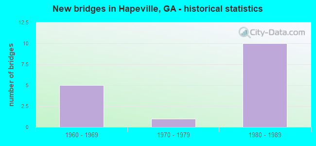
- New bridges - historical statistics
- 51960-1969
- 11970-1979
- 101980-1989
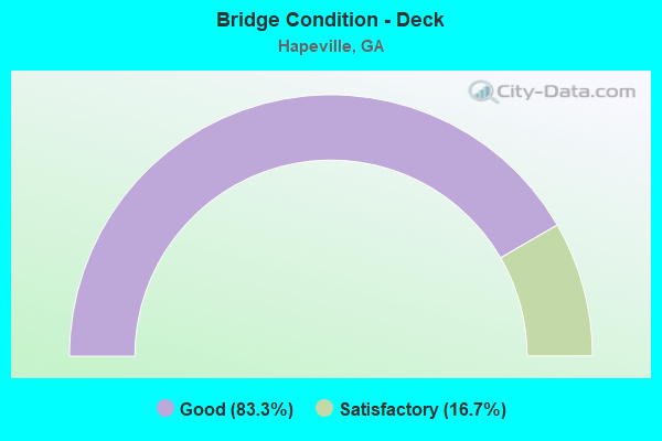
- Bridge Condition - Deck
- 83.3%Good
- 16.7%Satisfactory
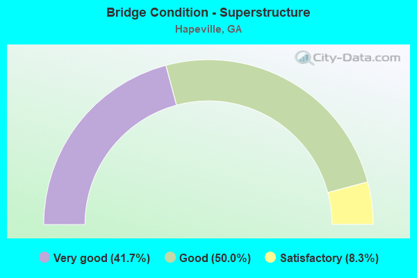
- Bridge Condition - Superstructure
- 41.7%Very good
- 50.0%Good
- 8.3%Satisfactory
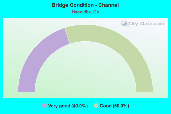
- Bridge Condition - Channel
- 40.0%Very good
- 60.0%Good
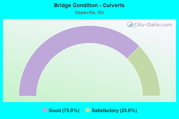
- Bridge Condition - Culverts
- 75.0%Good
- 25.0%Satisfactory
Find on map >> Show street view
Structure Number: 630111, Location: 0.1 MI E OF ATL AIRPORT (Lat: 33.642517, Lng: -84.401047), Route carried "on" structure: Ramp Interstate 75, Year Built: 1984, Status: Open, Structure Length: 0.79m (2.59ft), Average Daily Traffic: 13,440 (year 2012), Truck Traffic: 1%, Average Future Daily Traffic: 20,160 (year 2032), Design Load: HS 20+Mod, Features Intersected: MUD CREEK
Minimum Vertical Clearance: 30+ m (98+ ft), Kilometerpoint: 384.633, Lanes on structure: 1, Base Highway Network: Yes, Owner: State Highway Agency, Approaching Roadway Width: 7.9m (25.9ft), Material/Design: Concrete, Design/Construction: Culvert, Number Of Spans In Main Unit: 3, Length of Maximum Span: 2.4m (7.9ft)
Condition: Channel: Good, Culverts: Good, Structural Evaluation: Better than present minimum criteria, Waterway Adequacy: Superior to present desirable criteria, Approach Roadway Alignment: Equal to present desirable criteria, Designated Inspection Frequency: Every 24 months, Inspection Date: May 2021
Find on map >> Show street view
Structure Number: 630112, Location: 0.1 MI E OF ATL AIRPORT (Lat: 33.642789, Lng: -84.401447), Route carried "on" structure: Ramp Interstate 75, Year Built: 1984, Status: Open, Structure Length: 4.18m (13.71ft), Average Daily Traffic: 1,930 (year 2012), Truck Traffic: 1%, Average Future Daily Traffic: 2,895 (year 2032), Design Load: HS 20+Mod, Features Intersected: I-75 RAMP TO I-285 WBL
Minimum Vertical Clearance: 30+ m (98+ ft), Kilometerpoint: 384.633, Lanes on structure: 1, Lanes under structure: 1, Base Highway Network: Yes, Owner: State Highway Agency, Approaching Roadway Width: 7.9m (25.9ft), Skew: 6 degrees, Material/Design: Prestressed concrete, Design/Construction: Stringer/Multi-beam, Number Of Spans In Main Unit: 1, Length of Maximum Span: 41.8m (137.1ft), Curb-To-Curb Width: 9.1m (29.9ft), Out-to-Out Width: 21.2m (69.6ft)
Condition: Deck: Good, Superstructure: Very good, Substructure: Good, Operating Rating: 55.3 metric tons, Method Used To Determine Operating Rating: Load Factor (LF), Inventory Rating: 32.6 metric tons, Method Used To Determine Inventory Rating: Load Factor (LF), Structural Evaluation: Better than present minimum criteria, Deck Geometry: Superior to present desirable criteria, Underclear: Somewhat better than minimum adequacy, Approach Roadway Alignment: Equal to present desirable criteria, Designated Inspection Frequency: Every 24 months, Inspection Date: June 2021, Deck Structure Type: Concrete Cast-file-Place
Find on map >> Show street view
Structure Number: 630113, Location: 0.1 MI E OF ATL AIRPORT (Lat: 33.643844, Lng: -84.400144), Route carried "on" structure: Ramp Interstate 75, Year Built: 1983, Status: Open, Structure Length: 2.90m (9.51ft), Average Daily Traffic: 5,230 (year 2012), Truck Traffic: 1%, Average Future Daily Traffic: 7,845 (year 2032), Design Load: HS 20+Mod, Features Intersected: I-75 RAMP TO I-285 WBL
Minimum Vertical Clearance: 30+ m (98+ ft), Kilometerpoint: 384.633, Lanes on structure: 1, Lanes under structure: 1, Base Highway Network: Yes, Owner: State Highway Agency, Approaching Roadway Width: 10.7m (35.1ft), Skew: 5 degrees, Material/Design: Prestressed concrete, Design/Construction: Stringer/Multi-beam, Number Of Spans In Main Unit: 1, Length of Maximum Span: 29.0m (95.1ft), Curb-To-Curb Width: 9.1m (29.9ft), Out-to-Out Width: 10.1m (33.1ft)
Condition: Deck: Good, Superstructure: Good, Substructure: Good, Operating Rating: 55.3 metric tons, Method Used To Determine Operating Rating: Load Factor (LF), Inventory Rating: 32.6 metric tons, Method Used To Determine Inventory Rating: Load Factor (LF), Structural Evaluation: Better than present minimum criteria, Deck Geometry: Superior to present desirable criteria, Underclear: Meets minimum limits, Approach Roadway Alignment: Equal to present desirable criteria, Designated Inspection Frequency: Every 24 months, Inspection Date: June 2021, Deck Structure Type: Concrete Cast-file-Place
Find on map >> Show street view
Structure Number: 630114, Location: 0.1 MI E OF ATL AIRPORT (Lat: 33.643311, Lng: -84.400872), Route carried "on" structure: Ramp Interstate 75, Year Built: 1984, Status: Open, Structure Length: 0.79m (2.59ft), Average Daily Traffic: 2,910 (year 2012), Truck Traffic: 1%, Average Future Daily Traffic: 4,365 (year 2032), Design Load: HS 20+Mod, Features Intersected: MUD CREEK
Minimum Vertical Clearance: 30+ m (98+ ft), Kilometerpoint: 384.633, Lanes on structure: 1, Base Highway Network: Yes, Owner: State Highway Agency, Approaching Roadway Width: 10.4m (34.1ft), Skew: 5 degrees, Material/Design: Concrete, Design/Construction: Culvert, Number Of Spans In Main Unit: 2, Length of Maximum Span: 3.7m (12.1ft)
Condition: Channel: Good, Culverts: Good, Structural Evaluation: Better than present minimum criteria, Waterway Adequacy: Superior to present desirable criteria, Approach Roadway Alignment: Equal to present desirable criteria, Designated Inspection Frequency: Every 24 months, Inspection Date: May 2021
Find on map >> Show street view
Structure Number: 630116, Location: 0.11 MI E OF ATL AIRPORT (Lat: 33.640542, Lng: -84.399883), Route carried "on" structure: County highway 1516, Year Built: 1984, Status: Open, Structure Length: 5.70m (18.70ft), Average Daily Traffic: 24,420 (year 2012), Truck Traffic: 1%, Average Future Daily Traffic: 36,630 (year 2032), Design Load: HS 20+Mod, Features Intersected: I-75 (NBL) & CR 1511, Facility Carried by Structure: CHARLES W GRANT PK
Minimum Vertical Clearance: 30+ m (98+ ft), Kilometerpoint: 1.609, Lanes on structure: 7, Lanes under structure: 8, Base Highway Network: Yes, Owner: State Highway Agency, Approaching Roadway Width: 28.0m (91.9ft), Skew: 20 degrees, Material/Design: Steel continuous, Design/Construction: Stringer/Multi-beam, Number Of Spans In Main Unit: 2, Length of Maximum Span: 31.1m (102.0ft), Curb-To-Curb Width: 28.0m (91.9ft), Out-to-Out Width: 29.0m (95.1ft)
Condition: Deck: Good, Superstructure: Very good, Substructure: Good, Operating Rating: 51.7 metric tons, Method Used To Determine Operating Rating: Load Factor (LF), Inventory Rating: 30.8 metric tons, Method Used To Determine Inventory Rating: Load Factor (LF), Structural Evaluation: Better than present minimum criteria, Deck Geometry: Somewhat better than minimum adequacy, Underclear: Superior to present desirable criteria, Approach Roadway Alignment: Equal to present desirable criteria, Designated Inspection Frequency: Every 24 months, Inspection Date: April 2021, Deck Structure Type: Concrete Cast-file-Place, Wearing Surface/Protective System: Wearing Surface: Epoxy Overlay
Find on map >> Show street view
Structure Number: 630117, Location: 0.1 MI E OF ATL AIRPORT (Lat: 33.640794, Lng: -84.400611), Route carried "on" structure: County highway 1516, Year Built: 1984, Status: Open, Structure Length: 5.49m (18.01ft), Average Daily Traffic: 24,420 (year 2012), Truck Traffic: 1%, Average Future Daily Traffic: 36,630 (year 2032), Design Load: HS 20+Mod, Features Intersected: I-75 (SBL) & I-75 RAMP, Facility Carried by Structure: CHARLES W GRANT PK
Minimum Vertical Clearance: 30+ m (98+ ft), Kilometerpoint: 1.609, Lanes on structure: 7, Lanes under structure: 7, Base Highway Network: Yes, Owner: State Highway Agency, Approaching Roadway Width: 53.6m (175.9ft), Skew: 20 degrees, Material/Design: Steel continuous, Design/Construction: Stringer/Multi-beam, Number Of Spans In Main Unit: 2, Length of Maximum Span: 27.4m (89.9ft), Curb-To-Curb Width: 28.0m (91.9ft), Out-to-Out Width: 29.0m (95.1ft)
Condition: Deck: Good, Superstructure: Very good, Substructure: Good, Operating Rating: 39.9 metric tons, Method Used To Determine Operating Rating: Load Factor (LF), Inventory Rating: 23.5 metric tons, Method Used To Determine Inventory Rating: Load Factor (LF), Structural Evaluation: Somewhat better than minimum adequacy, Deck Geometry: Somewhat better than minimum adequacy, Underclear: Somewhat better than minimum adequacy, Approach Roadway Alignment: Equal to present desirable criteria, Designated Inspection Frequency: Every 24 months, Inspection Date: April 2021, Deck Structure Type: Concrete Cast-file-Place, Wearing Surface/Protective System: Wearing Surface: Epoxy Overlay
Find on map >> Show street view
Structure Number: 630118, Location: 0.08 MI E OF ATL AIRPORT (Lat: 33.641053, Lng: -84.402400), Route carried "on" structure: County highway 1516, Year Built: 1984, Status: Open, Structure Length: 5.49m (18.01ft), Average Daily Traffic: 24,420 (year 2012), Truck Traffic: 1%, Average Future Daily Traffic: 36,630 (year 2032), Design Load: HS 20+Mod, Features Intersected: I-75 RAMP TO I-285, Facility Carried by Structure: AVIATION BOULEVARD
Minimum Vertical Clearance: 30+ m (98+ ft), Kilometerpoint: 1.609, Lanes on structure: 7, Lanes under structure: 2, Base Highway Network: Yes, Owner: State Highway Agency, Approaching Roadway Width: 26.8m (87.9ft), Material/Design: Prestressed concrete continuous, Design/Construction: Box Beam or Girders - Multiple, Number Of Spans In Main Unit: 1, Length of Maximum Span: 54.9m (180.1ft), Curb-To-Curb Width: 28.0m (91.9ft), Out-to-Out Width: 29.0m (95.1ft)
Condition: Deck: Good, Superstructure: Good, Substructure: Good, Operating Rating: 46.2 metric tons, Method Used To Determine Operating Rating: Allowable Stress (AS), Inventory Rating: 32.6 metric tons, Method Used To Determine Inventory Rating: Allowable Stress (AS), Structural Evaluation: Better than present minimum criteria, Deck Geometry: Somewhat better than minimum adequacy, Underclear: Superior to present desirable criteria, Approach Roadway Alignment: Equal to present desirable criteria, Designated Inspection Frequency: Every 24 months, Inspection Date: April 2021, Deck Structure Type: Concrete Precast Panels, Wearing Surface/Protective System: Wearing Surface: Epoxy Overlay
Find on map >> Show street view
Structure Number: 635034, Location: 0.1 MI E OF ATL AIRPORT (Lat: 33.641008, Lng: -84.401119), Route carried "on" structure: County highway 1516, Year Built: 1984, Status: Open, Structure Length: 0.85m (2.79ft), Average Daily Traffic: 24,420 (year 2012), Truck Traffic: 1%, Average Future Daily Traffic: 36,630 (year 2032), Design Load: HS 20+Mod, Features Intersected: MUD CREEK, Facility Carried by Structure: AVIATON BOULEVARD
Minimum Vertical Clearance: 30+ m (98+ ft), Kilometerpoint: 1.609, Lanes on structure: 7, Base Highway Network: Yes, Owner: County Highway Agency, Approaching Roadway Width: 26.8m (87.9ft), Skew: 20 degrees, Material/Design: Concrete, Design/Construction: Culvert, Number Of Spans In Main Unit: 3, Length of Maximum Span: 3.0m (9.8ft)
Condition: Channel: Very good, Culverts: Satisfactory, Structural Evaluation: Equal to present minimum criteria, Waterway Adequacy: Superior to present desirable criteria, Approach Roadway Alignment: Equal to present desirable criteria, Designated Inspection Frequency: Every 24 months, Inspection Date: May 2021
Find on map >> Show street view
Structure Number: 121021, Location: IN N ATLANTA (Lat: 33.818669, Lng: -84.360939), Route carried "on" structure: State highway 13, Year Built: 1984, Status: Open, Structure Length: 7.83m (25.69ft), Average Daily Traffic: 71,520 (year 2012), Truck Traffic: 1%, Average Future Daily Traffic: 107,280 (year 2032), Design Load: HS 20+Mod, Features Intersected: PEACHTREE CREEK
Minimum Vertical Clearance: 30+ m (98+ ft), Kilometerpoint: 4.828, Lanes on structure: 5, Base Highway Network: Yes, Owner: State Highway Agency, Approaching Roadway Width: 28.3m (92.8ft), Skew: 30 degrees, Material/Design: Prestressed concrete, Design/Construction: Stringer/Multi-beam, Number Of Spans In Main Unit: 3, Length of Maximum Span: 33.5m (109.9ft), Curb-To-Curb Width: 35.0m (114.8ft), Out-to-Out Width: 36.0m (118.1ft)
Condition: Deck: Good, Superstructure: Very good, Substructure: Good, Channel: Very good, Operating Rating: 56.2 metric tons, Method Used To Determine Operating Rating: Load Factor (LF), Inventory Rating: 33.5 metric tons, Method Used To Determine Inventory Rating: Load Factor (LF), Structural Evaluation: Better than present minimum criteria, Deck Geometry: Superior to present desirable criteria, Waterway Adequacy: Equal to present desirable criteria, Approach Roadway Alignment: Equal to present desirable criteria, Designated Inspection Frequency: Every 24 months, Inspection Date: May 2021, Bridge Improvement Cost: $1,826,000, Roadway Improvement Cost: $183,000, Total Project Cost: $2,739,000, Deck Structure Type: Concrete Cast-file-Place
Find on map >> Show street view
Structure Number: 1210214, Location: IN COLLEGE PARK (Lat: 33.661889, Lng: -84.426889), Route carried "on" structure: Spur Interstate 85, Year Built: 1963, Status: Open, Structure Length: 10.00m (32.81ft), Average Daily Traffic: 2,450 (year 2012), Truck Traffic: 1%, Average Future Daily Traffic: 3,675 (year 2032), Design Load: HS 20+Mod, Features Intersected: I-85
Minimum Vertical Clearance: 30+ m (98+ ft), Kilometerpoint: 119.092, Lanes on structure: 2, Lanes under structure: 6, Base Highway Network: Yes, Owner: State Highway Agency, Approaching Roadway Width: 8.5m (27.9ft), Skew: 5 degrees, Material/Design: Steel, Design/Construction: Stringer/Multi-beam, Number Of Spans In Main Unit: 4, Length of Maximum Span: 28.7m (94.2ft), Curb or Sidewalk Widths: Left: 0.8m (2.6ft), Right: 0.8m (2.6ft), Curb-To-Curb Width: 8.5m (27.9ft), Out-to-Out Width: 10.5m (34.4ft)
Condition: Deck: Good, Superstructure: Very good, Substructure: Good, Operating Rating: 32.6 metric tons, Method Used To Determine Operating Rating: Load Factor (LF), Inventory Rating: 19.0 metric tons, Method Used To Determine Inventory Rating: Load Factor (LF), Structural Evaluation: Meets minimum limits, Deck Geometry: High priority of corrective action, Underclear: Somewhat better than minimum adequacy, Approach Roadway Alignment: Equal to present desirable criteria, Designated Inspection Frequency: Every 24 months, Inspection Date: August 2020, Deck Structure Type: Concrete Cast-file-Place, Wearing Surface/Protective System: Wearing Surface: Epoxy Overlay
Find on map >> Show street view
Structure Number: 1210372, Location: IN COLLEGE PARK (Lat: 33.663889, Lng: -84.421989), Route carried "on" structure: City street 9080, Year Built: 1963, Status: Open, Structure Length: 9.66m (31.69ft), Average Daily Traffic: 4,160 (year 2012), Truck Traffic: 1%, Average Future Daily Traffic: 6,240 (year 2032), Design Load: HS 20+Mod, Features Intersected: I-85, Facility Carried by Structure: WILLINGHAM DRIVE
Minimum Vertical Clearance: 30+ m (98+ ft), Kilometerpoint: 1.609, Lanes on structure: 2, Lanes under structure: 8, Base Highway Network: Yes, Owner: State Highway Agency, Approaching Roadway Width: 9.1m (29.9ft), Skew: 5 degrees, Material/Design: Steel, Design/Construction: Stringer/Multi-beam, Number Of Spans In Main Unit: 4, Length of Maximum Span: 33.5m (109.9ft), Curb or Sidewalk Widths: Left: 1.5m (4.9ft), Right: 1.5m (4.9ft), Curb-To-Curb Width: 9.1m (29.9ft), Out-to-Out Width: 12.8m (42.0ft)
Condition: Deck: Good, Superstructure: Good, Substructure: Good, Operating Rating: 42.6 metric tons, Method Used To Determine Operating Rating: Load Factor (LF), Inventory Rating: 25.4 metric tons, Method Used To Determine Inventory Rating: Load Factor (LF), Structural Evaluation: Equal to present minimum criteria, Deck Geometry: Meets minimum limits, Underclear: High priority of corrective action, Approach Roadway Alignment: Equal to present desirable criteria, Designated Inspection Frequency: Every 24 months, Inspection Date: August 2020, Deck Structure Type: Concrete Cast-file-Place, Wearing Surface/Protective System: Wearing Surface: Epoxy Overlay
Find on map >> Show street view
Structure Number: 1210381, Location: IN HAPEVILLE (Lat: 33.658969, Lng: -84.426850), Route carried "on" structure: City street 9095, Year Built: 1960, Status: Open, Structure Length: 4.72m (15.49ft), Average Daily Traffic: 11,540 (year 2012), Truck Traffic: 1%, Average Future Daily Traffic: 17,310 (year 2032), Design Load: HS 20+Mod, Features Intersected: I-85 SPUR, Facility Carried by Structure: VIRGINIA AVE.
Minimum Vertical Clearance: 30+ m (98+ ft), Kilometerpoint: 1.609, Lanes on structure: 4, Lanes under structure: 4, Base Highway Network: Yes, Owner: State Highway Agency, Approaching Roadway Width: 15.8m (51.8ft), Material/Design: Concrete continuous, Design/Construction: Slab, Number Of Spans In Main Unit: 4, Length of Maximum Span: 13.4m (44.0ft), Curb or Sidewalk Widths: Left: 1.5m (4.9ft), Right: 1.5m (4.9ft), Curb-To-Curb Width: 15.8m (51.8ft), Out-to-Out Width: 20.0m (65.6ft)
Condition: Deck: Satisfactory, Superstructure: Satisfactory, Substructure: Good, Operating Rating: 45.3 metric tons, Method Used To Determine Operating Rating: Allowable Stress (AS), Inventory Rating: 32.6 metric tons, Method Used To Determine Inventory Rating: Allowable Stress (AS), Structural Evaluation: Equal to present minimum criteria, Deck Geometry: Meets minimum limits, Underclear: Equal to present minimum criteria, Approach Roadway Alignment: Equal to present desirable criteria, Designated Inspection Frequency: Every 24 months, Inspection Date: March 2021, Deck Structure Type: Concrete Cast-file-Place
Find on map >> Show street view
Structure Number: 1210471, Location: IN HAPEVILLE (Lat: 33.672058, Lng: -84.414569), Route carried "on" structure: City street 8041, Year Built: 1963, Status: Open, Structure Length: 6.80m (22.31ft), Average Daily Traffic: 1,930 (year 2012), Truck Traffic: 1%, Average Future Daily Traffic: 2,895 (year 2032), Design Load: HS 20+Mod, Features Intersected: I-85, Facility Carried by Structure: COFIELD DRIVE
Minimum Vertical Clearance: 30+ m (98+ ft), Kilometerpoint: 0.000, Lanes on structure: 2, Lanes under structure: 6, Base Highway Network: Yes, Owner: State Highway Agency, Approaching Roadway Width: 7.9m (25.9ft), Skew: 1 degrees, Material/Design: Steel, Design/Construction: Stringer/Multi-beam, Number Of Spans In Main Unit: 4, Length of Maximum Span: 19.2m (63.0ft), Curb or Sidewalk Widths: Left: 1.5m (4.9ft), Right: 1.5m (4.9ft), Curb-To-Curb Width: 8.5m (27.9ft), Out-to-Out Width: 12.0m (39.4ft)
Condition: Deck: Satisfactory, Superstructure: Good, Substructure: Good, Operating Rating: 43.5 metric tons, Method Used To Determine Operating Rating: Load Factor (LF), Inventory Rating: 26.3 metric tons, Method Used To Determine Inventory Rating: Load Factor (LF), Structural Evaluation: Equal to present minimum criteria, Deck Geometry: Somewhat better than minimum adequacy, Underclear: Meets minimum limits, Approach Roadway Alignment: Equal to present desirable criteria, Designated Inspection Frequency: Every 24 months, Inspection Date: March 2021, Bridge Improvement Cost: $871,000, Roadway Improvement Cost: $87,000, Total Project Cost: $1,307,000, Deck Structure Type: Concrete Cast-file-Place
Find on map >> Show street view
Structure Number: 1210561, Location: 1 M E OF HAPEVILLE (Lat: 33.652378, Lng: -84.396239), Route carried "on" structure: City street 9079, Year Built: 1984, Status: Open, Structure Length: 11.80m (38.71ft), Average Daily Traffic: 5,770 (year 2012), Truck Traffic: 1%, Average Future Daily Traffic: 8,655 (year 2032), Design Load: HS 20+Mod, Features Intersected: I-75, NBCD, SBCD, Facility Carried by Structure: PORSCHE AVENUE
Minimum Vertical Clearance: 30+ m (98+ ft), Kilometerpoint: 0.000, Lanes on structure: 4, Lanes under structure: 16, Base Highway Network: Yes, Owner: State Highway Agency, Approaching Roadway Width: 19.5m (64.0ft), Material/Design: Steel, Design/Construction: Stringer/Multi-beam, Number Of Spans In Main Unit: 6, Length of Maximum Span: 25.3m (83.0ft), Curb or Sidewalk Widths: Left: 0.0m, Right: 2.6m (8.5ft), Curb-To-Curb Width: 19.5m (64.0ft), Out-to-Out Width: 23.0m (75.5ft)
Condition: Deck: Good, Superstructure: Good, Substructure: Good, Operating Rating: 56.2 metric tons, Method Used To Determine Operating Rating: Load Factor (LF), Inventory Rating: 33.5 metric tons, Method Used To Determine Inventory Rating: Load Factor (LF), Structural Evaluation: Better than present minimum criteria, Deck Geometry: Better than present minimum criteria, Underclear: Somewhat better than minimum adequacy, Approach Roadway Alignment: Equal to present desirable criteria, Designated Inspection Frequency: Every 24 months, Inspection Date: August 2020, Deck Structure Type: Concrete Cast-file-Place, Wearing Surface/Protective System: Deck Protection: Epoxy Coated Reinforcing
Find on map >> Show street view
Structure Number: 1210671, Location: IN COLLEGE PARK (Lat: 33.663189, Lng: -84.423969), Route carried "on" structure: Interstate 85, Year Built: 1963, Status: Open, Structure Length: 0.91m (2.99ft), Average Daily Traffic: 129,040 (year 2012), Truck Traffic: 1%, Average Future Daily Traffic: 193,560 (year 2032), Design Load: HS 20+Mod, Features Intersected: FLINT RIVER TRIB
Minimum Vertical Clearance: 30+ m (98+ ft), Kilometerpoint: 119.092, Lanes on structure: 9, Base Highway Network: Yes, Owner: State Highway Agency, Approaching Roadway Width: 36.0m (118.1ft), Skew: 31 degrees, Material/Design: Concrete, Design/Construction: Culvert, Number Of Spans In Main Unit: 3, Length of Maximum Span: 2.7m (8.9ft)
Condition: Channel: Good, Culverts: Good, Operating Rating: 55.3 metric tons, Method Used To Determine Operating Rating: Field evaluation and documented engineering judgment, Inventory Rating: 32.6 metric tons, Method Used To Determine Inventory Rating: Field evaluation and documented engineering judgment, Structural Evaluation: Better than present minimum criteria, Waterway Adequacy: Equal to present desirable criteria, Approach Roadway Alignment: Equal to present desirable criteria, Designated Inspection Frequency: Every 24 months, Inspection Date: December 2020
Find on map >> Show street view
Structure Number: 121527, Location: IN ATLANTA (Lat: 33.754619, Lng: -84.392069), Route carried "on" structure: City street 2038, Year Built: 1979, Year Reconstructed: 1996, Status: Open, Structure Length: 14.30m (46.92ft), Average Daily Traffic: 12,880 (year 2011), Truck Traffic: 1%, Average Future Daily Traffic: 19,320 (year 2031), Design Load: HS 20, Features Intersected: CSX RR & PARKING LOT, Facility Carried by Structure: FORSYTH STREET
Minimum Vertical Clearance: 30+ m (98+ ft), Kilometerpoint: 0.000, Lanes on structure: 4, Base Highway Network: Yes, Owner: City or Municipal Highway Agency, Approaching Roadway Width: 13.4m (44.0ft), Material/Design: Prestressed concrete, Design/Construction: Stringer/Multi-beam, Number Of Spans In Main Unit: 4, Number Of Approach Spans: 3, Length of Maximum Span: 26.8m (87.9ft), Curb or Sidewalk Widths: Left: 2.7m (8.9ft), Right: 2.4m (7.9ft), Curb-To-Curb Width: 13.4m (44.0ft), Out-to-Out Width: 19.2m (63.0ft)
Condition: Deck: Good, Superstructure: Good, Substructure: Good, Operating Rating: 55.3 metric tons, Method Used To Determine Operating Rating: Allowable Stress (AS), Inventory Rating: 32.6 metric tons, Method Used To Determine Inventory Rating: Allowable Stress (AS), Structural Evaluation: Better than present minimum criteria, Deck Geometry: High priority of replacement, Underclear: Superior to present desirable criteria, Approach Roadway Alignment: Better than present minimum criteria, Designated Inspection Frequency: Every 24 months, Inspection Date: October 2020, Bridge Improvement Cost: $2,832,000, Roadway Improvement Cost: $283,000, Total Project Cost: $4,248,000, Deck Structure Type: Concrete Cast-file-Place, Wearing Surface/Protective System: Wearing Surface: Bituminous
Find on map >> Show street view
Structure Number: 630112, Location: 0.1 MI E OF ATL AIRPORT (Lat: 33.642789, Lng: -84.401447), Route carried "under" structure: Ramp Interstate 75, Structure Length: 0. m, Average Daily Traffic: 1,200 (year 2009), Truck Traffic: 10%, Features Intersected: I-75 RAMP TO CR 1516
Minimum Vertical Clearance: 6.24m (20.47ft), Kilometerpoint: 384.633, Lanes on structure: 1, Length of Maximum Span: 0.0m
Find on map >> Show street view
Structure Number: 630113, Location: 0.1 MI E OF ATL AIRPORT (Lat: 33.643844, Lng: -84.400144), Route carried "under" structure: Ramp Interstate 75, Structure Length: 0. m, Average Daily Traffic: 1,640 (year 2009), Truck Traffic: 10%, Features Intersected: I-75 RAMP TO I-75 SB CD
Minimum Vertical Clearance: 5.48m (17.98ft), Kilometerpoint: 384.633, Lanes on structure: 1, Length of Maximum Span: 0.0m
Find on map >> Show street view
Structure Number: 630116, Location: 0.11 MI E OF ATL AIRPORT (Lat: 33.640542, Lng: -84.399883), Route carried "under" structure: Interstate 75, Structure Length: 0. m, Average Daily Traffic: 41,225 (year 2010), Truck Traffic: 10%, Features Intersected: CR 1516, Facility Carried by Structure: CHARLES W GRANT PK
Minimum Vertical Clearance: 5.71m (18.73ft), Kilometerpoint: 384.633, Lanes on structure: 7, Length of Maximum Span: 0.0m
Find on map >> Show street view
Structure Number: 630116, Location: 0.11 MI E OF ATL AIRPORT (Lat: 33.640542, Lng: -84.399883), Route carried "under" structure: County highway 1511, Structure Length: 0. m, Average Daily Traffic: 550 (year 1999), Truck Traffic: 1%, Features Intersected: CR 1516, Facility Carried by Structure: CHARLES W GRANT PK
Minimum Vertical Clearance: 5.76m (18.90ft), Kilometerpoint: 1.609, Lanes on structure: 7, Length of Maximum Span: 0.0m
Find on map >> Show street view
Structure Number: 630117, Location: 0.1 MI E OF ATL AIRPORT (Lat: 33.640794, Lng: -84.400611), Route carried "under" structure: Interstate 75, Structure Length: 0. m, Average Daily Traffic: 117,800 (year 2010), Truck Traffic: 1%, Features Intersected: CR 1516, Facility Carried by Structure: CHARLES W GRANT PK
Minimum Vertical Clearance: 6.07m (19.91ft), Kilometerpoint: 384.633, Lanes on structure: 7, Length of Maximum Span: 0.0m
Find on map >> Show street view
Structure Number: 630117, Location: 0.1 MI E OF ATL AIRPORT (Lat: 33.640794, Lng: -84.400611), Route carried "under" structure: Ramp Interstate 75, Structure Length: 0. m, Average Daily Traffic: 10,500 (year 1999), Truck Traffic: 1%, Features Intersected: CR 1516, Facility Carried by Structure: CHARLES W GRANT PK
Minimum Vertical Clearance: 6.17m (20.24ft), Kilometerpoint: 384.633, Lanes on structure: 7, Length of Maximum Span: 0.0m
Find on map >> Show street view
Structure Number: 630118, Location: 0.08 MI E OF ATL AIRPORT (Lat: 33.641053, Lng: -84.402400), Route carried "under" structure: Ramp Interstate 75, Structure Length: 0. m, Average Daily Traffic: 900 (year 2010), Truck Traffic: 1%, Features Intersected: CR 1516, Facility Carried by Structure: AVIATION BOULEVARD
Minimum Vertical Clearance: 6.09m (19.98ft), Kilometerpoint: 384.633, Lanes on structure: 7, Length of Maximum Span: 0.0m
Find on map >> Show street view
Structure Number: 1210001, Location: 0.4 MI N CLAYTON CO LINE (Lat: 33.652858, Lng: -84.395939), Route carried "under" structure: Interstate 75, Structure Length: 0. m, Average Daily Traffic: 164,500 (year 1999), Truck Traffic: 1%, Features Intersected: SR 3 (US 19) CENTRAL AVE, Facility Carried by Structure: CENTRAL AVE. US 19
Minimum Vertical Clearance: 6.75m (22.15ft), Kilometerpoint: 386.243, Lanes on structure: 6, Length of Maximum Span: 0.0m
Find on map >> Show street view
Structure Number: 1210001, Location: 0.4 MI N CLAYTON CO LINE (Lat: 33.652858, Lng: -84.395939), Route carried "under" structure: Ramp Interstate 75, Structure Length: 0. m, Average Daily Traffic: 11,000 (year 1995), Truck Traffic: 1%, Features Intersected: SR 3 (US 19) CENTRAL AVE, Facility Carried by Structure: CENTRAL AVE. US 19
Minimum Vertical Clearance: 7.23m (23.72ft), Kilometerpoint: 386.243, Lanes on structure: 6, Length of Maximum Span: 0.0m
Find on map >> Show street view
Structure Number: 1210001, Location: 0.4 MI N CLAYTON CO LINE (Lat: 33.652858, Lng: -84.395939), Route carried "under" structure: Ramp Interstate 75, Structure Length: 0. m, Average Daily Traffic: 11,000 (year 1995), Truck Traffic: 1%, Features Intersected: SR 3 (US 19) CENTRAL AVE, Facility Carried by Structure: CENTRAL AVE. US 19
Minimum Vertical Clearance: 6.70m (21.98ft), Kilometerpoint: 386.243, Lanes on structure: 6, Length of Maximum Span: 0.0m
Find on map >> Show street view
Structure Number: 1210214, Location: IN COLLEGE PARK (Lat: 33.661889, Lng: -84.426889), Route carried "under" structure: Interstate 85, Structure Length: 0. m, Average Daily Traffic: 126,400 (year 2010), Truck Traffic: 1%, Features Intersected: I-85 SPUR AIRPORT CONN.
Minimum Vertical Clearance: 5.74m (18.83ft), Kilometerpoint: 119.092, Lanes on structure: 2, Length of Maximum Span: 0.0m
Find on map >> Show street view
Structure Number: 121037, Location: IN HAPEVILLE (Lat: 33.664417, Lng: -84.420486), Route carried "under" structure: Interstate 85, Structure Length: 0. m, Average Daily Traffic: 126,400 (year 2010), Truck Traffic: 1%, Features Intersected: M-9079 CENTRAL AVENUE, Facility Carried by Structure: CENTRAL AVE.
Minimum Vertical Clearance: 6.85m (22.47ft), Kilometerpoint: 119.092, Lanes on structure: 2, Length of Maximum Span: 0.0m
Find on map >> Show street view
Structure Number: 1210372, Location: IN COLLEGE PARK (Lat: 33.663889, Lng: -84.421989), Route carried "under" structure: Interstate 85, Structure Length: 0. m, Average Daily Traffic: 126,400 (year 2010), Truck Traffic: 1%, Features Intersected: M-9080 WILLINGHAM DRIVE, Facility Carried by Structure: WILLINGHAM DRIVE
Minimum Vertical Clearance: 5.94m (19.49ft), Kilometerpoint: 119.092, Lanes on structure: 2, Length of Maximum Span: 0.0m
Find on map >> Show street view
Structure Number: 1210381, Location: IN HAPEVILLE (Lat: 33.658969, Lng: -84.426850), Route carried "under" structure: Spur Interstate 85, Structure Length: 0. m, Average Daily Traffic: 9,500 (year 1999), Truck Traffic: 1%, Features Intersected: M-9095 VIRGINIA AVE., Facility Carried by Structure: VIRGINIA AVE.
Minimum Vertical Clearance: 5.13m (16.83ft), Kilometerpoint: 119.092, Lanes on structure: 4, Length of Maximum Span: 0.0m
Find on map >> Show street view
Structure Number: 1210471, Location: IN HAPEVILLE (Lat: 33.672058, Lng: -84.414569), Route carried "under" structure: Interstate 85, Structure Length: 0. m, Average Daily Traffic: 132,800 (year 2010), Truck Traffic: 1%, Features Intersected: CS 8041 COFIELD DRIVE, Facility Carried by Structure: COFIELD DRIVE
Minimum Vertical Clearance: 6.45m (21.16ft), Kilometerpoint: 120.701, Lanes on structure: 2, Length of Maximum Span: 0.0m
Find on map >> Show street view
Structure Number: 1210479, Location: IN HAPEVILLE (Lat: 33.652639, Lng: -84.396058), Route carried "under" structure: Interstate 75, Structure Length: 0. m, Average Daily Traffic: 134,480 (year 2012), Truck Traffic: 1%, Features Intersected: I-75, Facility Carried by Structure: NORFOLK SOUTHERN
Minimum Vertical Clearance: 5.74m (18.83ft), Kilometerpoint: 386.243, Length of Maximum Span: 0.0m
Find on map >> Show street view
Structure Number: 1210479, Location: IN HAPEVILLE (Lat: 33.652639, Lng: -84.396058), Route carried "under" structure: Interstate 75, Structure Length: 0. m, Average Daily Traffic: 10,100 (year 1995), Features Intersected: I-75 NB COLLECTOR-DISTR, Facility Carried by Structure: NORFOLK SOUTHERN
Minimum Vertical Clearance: 6.17m (20.24ft), Kilometerpoint: 386.243, Length of Maximum Span: 0.0m
Find on map >> Show street view
Structure Number: 1210479, Location: IN HAPEVILLE (Lat: 33.652639, Lng: -84.396058), Route carried "under" structure: Interstate 75, Structure Length: 0. m, Average Daily Traffic: 10,100 (year 1995), Features Intersected: I-75 SBCD, Facility Carried by Structure: NORFOLK SOUTHERN
Minimum Vertical Clearance: 5.66m (18.57ft), Kilometerpoint: 386.243, Length of Maximum Span: 0.0m
Find on map >> Show street view
Structure Number: 1210486, Location: IN HAPEVILLE (Lat: 33.664589, Lng: -84.420328), Route carried "under" structure: Interstate 85, Structure Length: 0. m, Average Daily Traffic: 129,040 (year 2012), Truck Traffic: 1%, Features Intersected: I-85, Facility Carried by Structure: NORFOLK SOUTHERN R
Minimum Vertical Clearance: 5.23m (17.16ft), Kilometerpoint: 119.092, Length of Maximum Span: 0.0m
Find on map >> Show street view
Structure Number: 1210561, Location: 1 M E OF HAPEVILLE (Lat: 33.652378, Lng: -84.396239), Route carried "under" structure: Ramp Interstate 75, Structure Length: 0. m, Average Daily Traffic: 10,100 (year 1995), Truck Traffic: 1%, Features Intersected: PORSCHE AVE, Facility Carried by Structure: PORSCHE AVENUE
Minimum Vertical Clearance: 7.79m (25.56ft), Kilometerpoint: 386.243, Lanes on structure: 4, Length of Maximum Span: 0.0m
Find on map >> Show street view
Structure Number: 1210561, Location: 1 M E OF HAPEVILLE (Lat: 33.652378, Lng: -84.396239), Route carried "under" structure: Ramp Interstate 75, Structure Length: 0. m, Average Daily Traffic: 10,100 (year 1995), Truck Traffic: 1%, Features Intersected: PORSCHE AVE, Facility Carried by Structure: PORSCHE AVENUE
Minimum Vertical Clearance: 7.13m (23.39ft), Kilometerpoint: 386.243, Lanes on structure: 4, Length of Maximum Span: 0.0m
Find on map >> Show street view
Structure Number: 1210561, Location: 1 M E OF HAPEVILLE (Lat: 33.652378, Lng: -84.396239), Route carried "under" structure: Interstate 75, Structure Length: 0. m, Average Daily Traffic: 164,500 (year 1998), Truck Traffic: 1%, Features Intersected: PORSCHE AVE, Facility Carried by Structure: PORSCHE AVENUE
Minimum Vertical Clearance: 7.41m (24.31ft), Kilometerpoint: 386.243, Lanes on structure: 4, Length of Maximum Span: 0.0m
Find on map >> Show street view
Structure Number: 1215276, Location: IN EAST POINT (Lat: 33.649558, Lng: -84.443936), Route carried "under" structure: Interstate 85, Structure Length: 0. m, Average Daily Traffic: 87,680 (year 2020), Truck Traffic: 1%, Features Intersected: I-85, Facility Carried by Structure: AIRPORT LIGHTS
Minimum Vertical Clearance: 5.66m (18.57ft), Kilometerpoint: 118.448, Length of Maximum Span: 0.0m