Bridge Statistics for Hallandale, Florida (FL)
Condition, Traffic, Stress, Structural Evaluation, Project Costs
- National Bridge Inventory (NBI) Statistics
- 10Number of bridges
- 295ft / 90.3mTotal length
- 149,875Total average daily traffic
- 5,438Total average daily truck traffic
- National Bridge Inventory (NBI) Registered Bridges for Hallandale
- No street view available for this location
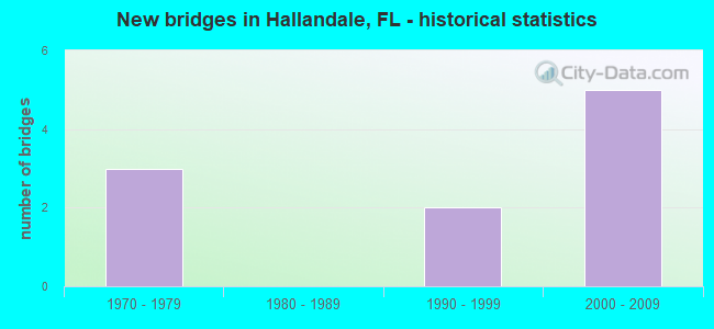
- New bridges - historical statistics
- 31970-1979
- 21990-1999
- 52000-2009


- Bridge Condition - Deck
- 28.6%Very good
- 57.1%Good
- 14.3%Poor

- Bridge Condition - Superstructure
- 85.7%Good
- 14.3%Poor

- Bridge Condition - Substructure
- 57.1%Very good
- 42.9%Good

- Bridge Condition - Channel
- 40.0%Very good
- 60.0%Good
Find on map >> Show street view
Structure Number: 860529, Location: I-95/Hallandale Beach Bvd (Lat: 25.984917, Lng: -80.165611), Route carried "on" structure: Interstate 95, Year Built: 1990, Year Reconstructed: 2013, Status: Open, Structure Length: 7.44m (24.41ft), Average Daily Traffic: 13,750 (year 2020), Truck Traffic: 8%, Average Future Daily Traffic: 23,856 (year 2042), Design Load: HL 93, Features Intersected: SR858 Hallandale Bch Bld
Minimum Vertical Clearance: 30+ m (98+ ft), Kilometerpoint: 1.197, Lanes on structure: 12, Lanes under structure: 10, Base Highway Network: Yes, Owner: State Highway Agency, Approaching Roadway Width: 50.7m (166.3ft), Skew: 30 degrees, Material/Design: Prestressed concrete, Design/Construction: Stringer/Multi-beam, Number Of Spans In Main Unit: 4, Length of Maximum Span: 25.6m (84.0ft), Curb-To-Curb Width: 55.3m (181.4ft), Out-to-Out Width: 56.8m (186.4ft)
Condition: Deck: Good, Superstructure: Good, Substructure: Very good, Operating Rating: 48.4 metric tons, Method Used To Determine Operating Rating: Load and Resistance Factor (LRFR), Inventory Rating: 33.9 metric tons, Method Used To Determine Inventory Rating: Load and Resistance Factor (LRFR), Structural Evaluation: Better than present minimum criteria, Deck Geometry: Superior to present desirable criteria, Underclear: Equal to present minimum criteria, Approach Roadway Alignment: Equal to present desirable criteria, Designated Inspection Frequency: Every 24 months, Inspection Date: August 2021, Deck Structure Type: Concrete Cast-file-Place
Find on map >> Show street view
Structure Number: 860618, Location: Hallandale Bch. Blvd/ICWW (Lat: 25.986344, Lng: -80.121642), Route carried "on" structure: State highway 858, Year Built: 2002, Status: Open, Structure Length: 22.30m (73.16ft), Average Daily Traffic: 14,250 (year 2020), Truck Traffic: 3%, Average Future Daily Traffic: 24,724 (year 2042), Design Load: HS 20+Mod, Features Intersected: Intracoastal Waterway
Minimum Vertical Clearance: 5.58m (18.31ft), Kilometerpoint: 8.436, Lanes on structure: 3, Owner: State Highway Agency, Approaching Roadway Width: 13.7m (44.9ft), Navigation Control: Yes ( Vertical Clearance: 8.1m (26.6ft), Horizontal Clearance: 38.1m (125.0ft)), Material/Design: Steel, Design/Construction: Movable - Bascule, Number Of Spans In Main Unit: 1, Number Of Approach Spans: 4, Length of Maximum Span: 48.7m (159.8ft), Curb or Sidewalk Widths: Left: 0.0m, Right: 2.1m (6.9ft), Curb-To-Curb Width: 14.4m (47.2ft), Out-to-Out Width: 17.8m (58.4ft)
Condition: Deck: Very good, Superstructure: Good, Substructure: Very good, Channel: Very good, Operating Rating: 55.5 metric tons, Method Used To Determine Operating Rating: Load Factor (LF), Inventory Rating: 37.9 metric tons, Method Used To Determine Inventory Rating: Load Factor (LF), Structural Evaluation: Better than present minimum criteria, Deck Geometry: Somewhat better than minimum adequacy, Waterway Adequacy: Superior to present desirable criteria, Approach Roadway Alignment: Equal to present minimum criteria, Designated Inspection Frequency: Every 24 months, Critical Feature Inspection Frequency: Every 24 months, Underwater Inspection Frequency: Every 24 months, Other Special Inspection Frequency: Every 12 months, Inspection Date: March 2021, Critical Feature Inspection Date: March 2021, Underwater Inspection Date: March 2021, Other Special Inspection Date: March 2021, Deck Structure Type: Concrete Cast-file-Place
Find on map >> Show street view
Structure Number: 860619, Location: Hallandale Bch. Blvd/ICWW (Lat: 25.986111, Lng: -80.122500), Route carried "on" structure: State highway 858, Year Built: 2000, Status: Open, Structure Length: 23.76m (77.95ft), Average Daily Traffic: 14,250 (year 2020), Truck Traffic: 3%, Average Future Daily Traffic: 24,724 (year 2042), Design Load: HS 20+Mod, Features Intersected: Intracoastal Waterway
Minimum Vertical Clearance: 5.85m (19.19ft), Kilometerpoint: 8.436, Lanes on structure: 3, Owner: State Highway Agency, Approaching Roadway Width: 9.6m (31.5ft), Navigation Control: Yes ( Vertical Clearance: 8.1m (26.6ft), Horizontal Clearance: 38.1m (125.0ft)), Material/Design: Steel, Design/Construction: Movable - Bascule, Number Of Spans In Main Unit: 1, Number Of Approach Spans: 5, Length of Maximum Span: 48.7m (159.8ft), Curb or Sidewalk Widths: Left: 2.1m (6.9ft), Right: 0.0m, Curb-To-Curb Width: 14.4m (47.2ft), Out-to-Out Width: 17.8m (58.4ft)
Condition: Deck: Very good, Superstructure: Good, Substructure: Very good, Channel: Very good, Operating Rating: 55.5 metric tons, Method Used To Determine Operating Rating: Load Factor (LF), Inventory Rating: 37.9 metric tons, Method Used To Determine Inventory Rating: Load Factor (LF), Structural Evaluation: Better than present minimum criteria, Deck Geometry: Somewhat better than minimum adequacy, Waterway Adequacy: Superior to present desirable criteria, Approach Roadway Alignment: Equal to present minimum criteria, Designated Inspection Frequency: Every 24 months, Critical Feature Inspection Frequency: Every 24 months, Underwater Inspection Frequency: Every 24 months, Other Special Inspection Frequency: Every 12 months, Inspection Date: March 2021, Critical Feature Inspection Date: March 2021, Underwater Inspection Date: March 2021, Other Special Inspection Date: March 2021, Deck Structure Type: Concrete Cast-file-Place
Find on map >> Show street view
Structure Number: 86062, Location: 1.8 Mile South of SR-820 (Lat: 25.986125, Lng: -80.119461), Route carried "on" structure: Ramp State highway A1A, Year Built: 2002, Status: Open, Structure Length: 18.76m (61.55ft), Average Daily Traffic: 8,250 (year 2020), Truck Traffic: 5%, Average Future Daily Traffic: 11,500 (year 2042), Design Load: HS 20+Mod, Features Intersected: SR-A1A SB & SR-858 EB
Minimum Vertical Clearance: 30+ m (98+ ft), Kilometerpoint: 0.122, Lanes on structure: 1, Lanes under structure: 6, Owner: State Highway Agency, Approaching Roadway Width: 8.4m (27.6ft), Material/Design: Prestressed concrete continuous, Design/Construction: Segmental Box Girder, Number Of Spans In Main Unit: 4, Length of Maximum Span: 57.0m (187.0ft), Curb-To-Curb Width: 8.4m (27.6ft), Out-to-Out Width: 9.4m (30.8ft)
Condition: Deck: Good, Superstructure: Good, Substructure: Very good, Operating Rating: 61.2 metric tons, Method Used To Determine Operating Rating: Load Factor (LF), Inventory Rating: 36.8 metric tons, Method Used To Determine Inventory Rating: Load Factor (LF), Structural Evaluation: Better than present minimum criteria, Deck Geometry: Superior to present desirable criteria, Underclear: Equal to present minimum criteria, Approach Roadway Alignment: Equal to present minimum criteria, Designated Inspection Frequency: Every 24 months, Inspection Date: April 2021, Deck Structure Type: Concrete Cast-file-Place
Find on map >> Show street view
Structure Number: 8661, Location: .02Mi E OF DIPLOMAT PKWY (Lat: 25.995322, Lng: -80.129483), Route carried "on" structure: City street , Year Built: 1978, Status: Posted for load-capacity, Structure Length: 6.86m (22.51ft), Average Daily Traffic: 8,403 (year 2021), Truck Traffic: 2%, Average Future Daily Traffic: 13,880 (year 2042), Design Load: HS 20+Mod, Features Intersected: THREE ISLAND CANAL, Facility Carried by Structure: ATLANTIC SHORES BL
Minimum Vertical Clearance: 30+ m (98+ ft), Kilometerpoint: 0.000, Lanes on structure: 4, Owner: City or Municipal Highway Agency, Approaching Roadway Width: 16.5m (54.1ft), Skew: 20 degrees, Material/Design: Prestressed concrete, Design/Construction: Slab, Number Of Spans In Main Unit: 5, Length of Maximum Span: 13.7m (44.9ft), Curb or Sidewalk Widths: Left: 1.5m (4.9ft), Right: 1.5m (4.9ft), Curb-To-Curb Width: 16.6m (54.5ft), Out-to-Out Width: 21.6m (70.9ft)
Condition: Deck: Poor, Superstructure: Poor, Substructure: Good, Channel: Good, Operating Rating: 52.3 metric tons, Method Used To Determine Operating Rating: Load and Resistance Factor (LRFR), Inventory Rating: 38.8 metric tons, Method Used To Determine Inventory Rating: Load and Resistance Factor (LRFR), Structural Evaluation: Meets minimum limits, Deck Geometry: Somewhat better than minimum adequacy, Waterway Adequacy: Better than present minimum criteria, Approach Roadway Alignment: Equal to present desirable criteria, Designated Inspection Frequency: Every 24 months, Underwater Inspection Frequency: Every 24 months, Other Special Inspection Frequency: Every 12 months, Inspection Date: Febuary 2021, Underwater Inspection Date: Febuary 2021, Other Special Inspection Date: Febuary 2021, Deck Structure Type: Concrete Precast Panels, Wearing Surface/Protective System: Wearing Surface: Bituminous
Find on map >> Show street view
Structure Number: 866101, Location: 0.1MI E OF 3 ISLAND BLVD. (Lat: 25.993753, Lng: -80.124258), Route carried "on" structure: City street , Year Built: 1978, Status: Open, Structure Length: 4.92m (16.14ft), Average Daily Traffic: 5,200 (year 2021), Truck Traffic: 4%, Average Future Daily Traffic: 8,675 (year 2042), Design Load: HS 20, Features Intersected: THREE ISLAND CANAL, Facility Carried by Structure: PARKVIEW DR
Minimum Vertical Clearance: 30+ m (98+ ft), Kilometerpoint: 0.000, Lanes on structure: 4, Owner: City or Municipal Highway Agency, Approaching Roadway Width: 14.5m (47.6ft), Skew: 20 degrees, Material/Design: Prestressed concrete, Design/Construction: Stringer/Multi-beam, Number Of Spans In Main Unit: 3, Length of Maximum Span: 16.5m (54.1ft), Curb or Sidewalk Widths: Left: 1.5m (4.9ft), Right: 1.5m (4.9ft), Curb-To-Curb Width: 16.7m (54.8ft), Out-to-Out Width: 21.6m (70.9ft)
Condition: Deck: Good, Superstructure: Good, Substructure: Good, Channel: Good, Operating Rating: 74.4 metric tons, Method Used To Determine Operating Rating: Load Factor (LF), Inventory Rating: 44.5 metric tons, Method Used To Determine Inventory Rating: Load Factor (LF), Structural Evaluation: Better than present minimum criteria, Deck Geometry: Somewhat better than minimum adequacy, Waterway Adequacy: Equal to present desirable criteria, Approach Roadway Alignment: Equal to present minimum criteria, Designated Inspection Frequency: Every 24 months, Underwater Inspection Frequency: Every 24 months, Inspection Date: January 2021, Underwater Inspection Date: January 2021, Deck Structure Type: Concrete Cast-file-Place
Find on map >> Show street view
Structure Number: 866102, Location: 0.2MI N OF SR-858 (Lat: 25.989331, Lng: -80.125881), Route carried "on" structure: City street , Year Built: 1970, Status: Open, Structure Length: 6.22m (20.41ft), Average Daily Traffic: 6,240 (year 2021), Truck Traffic: 5%, Average Future Daily Traffic: 10,410 (year 2042), Design Load: HS 20, Features Intersected: THREE ISLAND CANAL, Facility Carried by Structure: THREE ISLAND BLVD
Minimum Vertical Clearance: 30+ m (98+ ft), Kilometerpoint: 0.000, Lanes on structure: 6, Owner: City or Municipal Highway Agency, Approaching Roadway Width: 12.2m (40.0ft), Skew: 29 degrees, Material/Design: Prestressed concrete, Design/Construction: Stringer/Multi-beam, Number Of Spans In Main Unit: 3, Length of Maximum Span: 20.8m (68.2ft), Curb or Sidewalk Widths: Left: 1.6m (5.2ft), Right: 1.6m (5.2ft), Curb-To-Curb Width: 12.2m (40.0ft), Out-to-Out Width: 29.1m (95.5ft)
Condition: Deck: Good, Superstructure: Good, Substructure: Good, Channel: Good, Operating Rating: 76.2 metric tons, Method Used To Determine Operating Rating: Load Factor (LF), Inventory Rating: 45.4 metric tons, Method Used To Determine Inventory Rating: Load Factor (LF), Structural Evaluation: Better than present minimum criteria, Deck Geometry: High priority of replacement, Waterway Adequacy: Equal to present desirable criteria, Approach Roadway Alignment: Better than present minimum criteria, Designated Inspection Frequency: Every 24 months, Underwater Inspection Frequency: Every 24 months, Inspection Date: Febuary 2021, Underwater Inspection Date: Febuary 2021, Deck Structure Type: Concrete Cast-file-Place
Find on map >> Show street view
Structure Number: 860529, Location: I-95/Hallandale Beach Bvd (Lat: 25.984917, Lng: -80.165611), Route carried "under" structure: State highway 858, Year Built: 1990, Structure Length: 0. m, Average Daily Traffic: 47,532 (year 2020), Truck Traffic: 3%, Features Intersected: SR858 Hallandale Bch Bld, Facility Carried by Structure: I-95 (SR-9)
Minimum Vertical Clearance: 4.97m (16.31ft), Kilometerpoint: 4.083, Lanes on structure: 12, Lanes under structure: 10, Material/Design: Prestressed concrete, Design/Construction: Stringer/Multi-beam, Length of Maximum Span: 25.6m (84.0ft)
Find on map >> Show street view
Structure Number: 86062, Location: 1.8 Mile South of SR-820 (Lat: 25.986125, Lng: -80.119461), Route carried "under" structure: State highway A1A, Year Built: 2002, Structure Length: 0. m, Average Daily Traffic: 17,750 (year 2019), Truck Traffic: 3%, Features Intersected: SR-A1A SB & SR-858 EB
Minimum Vertical Clearance: 7.86m (25.79ft), Kilometerpoint: 1.215, Lanes on structure: 1, Lanes under structure: 4, Material/Design: Prestressed concrete continuous, Design/Construction: Segmental Box Girder, Length of Maximum Span: 57.0m (187.0ft)
Find on map >> Show street view
Structure Number: 86062, Location: 1.8 Mile South of SR-820 (Lat: 25.986125, Lng: -80.119461), Route carried "under" structure: State highway 858, Year Built: 2002, Structure Length: 0. m, Average Daily Traffic: 14,250 (year 2020), Truck Traffic: 3%, Features Intersected: SR-A1A SB & SR-858 EB
Minimum Vertical Clearance: 5.55m (18.21ft), Kilometerpoint: 8.737, Lanes on structure: 1, Lanes under structure: 1, Material/Design: Prestressed concrete continuous, Design/Construction: Segmental Box Girder, Length of Maximum Span: 57.0m (187.0ft)