Bridge Statistics for Halfway, Maryland (MD)
Condition, Traffic, Stress, Structural Evaluation, Project Costs
- National Bridge Inventory (NBI) Statistics
- 35Number of bridges
- 427ft / 130mTotal length
- $14,004,000Total costs
- 1,319,688Total average daily traffic
- 128,331Total average daily truck traffic
- National Bridge Inventory (NBI) Registered Bridges for Halfway
- No street view available for this location
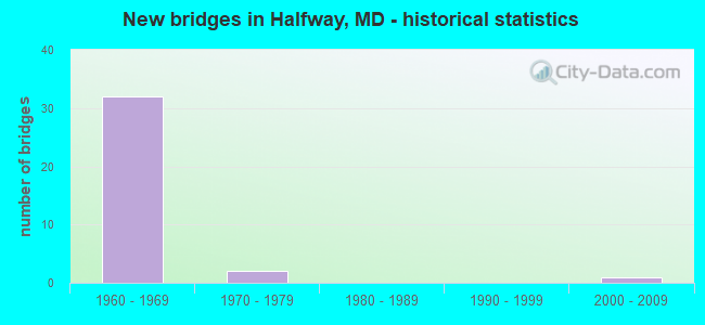
- New bridges - historical statistics
- 321960-1969
- 21970-1979
- 12000-2009

- Reconstructed bridges - Historical Statistics
- 31960-1969
- 21970-1979
- 01980-1989
- 11990-1999
- 22000-2009
- 22010-2019


- Bridge Condition - Deck
- 5.9%Very good
- 29.4%Good
- 29.4%Satisfactory
- 11.8%Fair
- 23.5%Poor

- Bridge Condition - Superstructure
- 41.2%Good
- 35.3%Satisfactory
- 17.6%Fair
- 5.9%Poor

- Bridge Condition - Substructure
- 23.5%Good
- 17.6%Satisfactory
- 47.1%Fair
- 11.8%Poor

- Bridge Condition - Channel
- 14.3%Very good
- 71.4%Good
- 14.3%Fair

- Bridge Condition - Culverts
- 57.1%Good
- 42.9%Satisfactory
Find on map >> Show street view
Structure Number: 100000210073014, Location: 0.33 MILE WEST OF US 11 (Lat: 39.617364, Lng: -77.785653), Route carried "on" structure: Interstate 70, Year Built: 1964, Year Reconstructed: 2018, Status: Open, Structure Length: 8.39m (27.53ft), Average Daily Traffic: 62,680 (year 2013), Truck Traffic: 23%, Average Future Daily Traffic: 57,660 (year 2033), Design Load: HS 20, Features Intersected: IS 81
Minimum Vertical Clearance: 30+ m (98+ ft), Kilometerpoint: 41.346, Lanes on structure: 2, Lanes under structure: 8, Base Highway Network: Yes, Owner: State Highway Agency, Approaching Roadway Width: 9.8m (32.2ft), Material/Design: Steel, Design/Construction: Stringer/Multi-beam, Number Of Spans In Main Unit: 6, Length of Maximum Span: 17.1m (56.1ft), Curb-To-Curb Width: 9.8m (32.2ft), Out-to-Out Width: 11.0m (36.1ft)
Condition: Deck: Very good, Superstructure: Good, Substructure: Good, Operating Rating: 73.9 metric tons, Method Used To Determine Operating Rating: Load Factor (LF), Inventory Rating: 44.4 metric tons, Method Used To Determine Inventory Rating: Load Factor (LF), Structural Evaluation: Better than present minimum criteria, Deck Geometry: Meets minimum limits, Underclear: Somewhat better than minimum adequacy, Approach Roadway Alignment: Equal to present desirable criteria, Length Of Structure Improvement: 8.38m (27.49ft), Designated Inspection Frequency: Every 24 months, Inspection Date: August 2021, Bridge Improvement Cost: $5,178,000, Roadway Improvement Cost: $2,801,000, Total Project Cost: $7,979,000 ( Estimate for 2018), Deck Structure Type: Concrete Cast-file-Place, Wearing Surface/Protective System: Wearing Surface: Monolithic Concrete, Deck Protection: Epoxy Coated Reinforcing
Find on map >> Show street view
Structure Number: 100000210074013, Location: 0.41 MILE WEST OF IS 81 (Lat: 39.621803, Lng: -77.790194), Route carried "on" structure: Interstate 70, Year Built: 1964, Year Reconstructed: 2012, Status: Open, Structure Length: 2.83m (9.28ft), Average Daily Traffic: 53,350 (year 2010), Truck Traffic: 26%, Average Future Daily Traffic: 71,950 (year 2030), Features Intersected: HOPEWELL RD
Minimum Vertical Clearance: 30+ m (98+ ft), Kilometerpoint: 40.714, Lanes on structure: 3, Lanes under structure: 2, Base Highway Network: Yes, Owner: State Highway Agency, Approaching Roadway Width: 15.5m (50.9ft), Material/Design: Steel, Design/Construction: Stringer/Multi-beam, Number Of Spans In Main Unit: 1, Number Of Approach Spans: 2, Length of Maximum Span: 14.3m (46.9ft), Curb-To-Curb Width: 15.2m (49.9ft), Out-to-Out Width: 16.3m (53.5ft)
Condition: Deck: Good, Superstructure: Good, Substructure: Satisfactory, Operating Rating: 70.3 metric tons, Method Used To Determine Operating Rating: Load Factor (LF), Inventory Rating: 42.2 metric tons, Method Used To Determine Inventory Rating: Load Factor (LF), Structural Evaluation: Equal to present minimum criteria, Deck Geometry: Meets minimum limits, Underclear: Equal to present minimum criteria, Approach Roadway Alignment: Equal to present desirable criteria, Designated Inspection Frequency: Every 24 months, Inspection Date: April 2020, Deck Structure Type: Concrete Cast-file-Place, Wearing Surface/Protective System: Wearing Surface: Latex Concrete, Deck Protection: Epoxy Coated Reinforcing
Find on map >> Show street view
Structure Number: 100000210074014, Location: 0.41 MILE WEST OF IS 81 (Lat: 39.621764, Lng: -77.789833), Route carried "on" structure: Interstate 70, Year Built: 1964, Year Reconstructed: 2012, Status: Open, Structure Length: 2.83m (9.28ft), Average Daily Traffic: 53,350 (year 2010), Truck Traffic: 26%, Average Future Daily Traffic: 71,950 (year 2030), Features Intersected: HOPEWELL RD
Minimum Vertical Clearance: 30+ m (98+ ft), Kilometerpoint: 40.714, Lanes on structure: 3, Lanes under structure: 2, Base Highway Network: Yes, Owner: State Highway Agency, Approaching Roadway Width: 15.2m (49.9ft), Material/Design: Steel, Design/Construction: Stringer/Multi-beam, Number Of Spans In Main Unit: 1, Number Of Approach Spans: 2, Length of Maximum Span: 14.3m (46.9ft), Curb-To-Curb Width: 15.1m (49.5ft), Out-to-Out Width: 16.2m (53.1ft)
Condition: Deck: Good, Superstructure: Good, Substructure: Satisfactory, Operating Rating: 70.3 metric tons, Method Used To Determine Operating Rating: Load Factor (LF), Inventory Rating: 42.2 metric tons, Method Used To Determine Inventory Rating: Load Factor (LF), Structural Evaluation: Equal to present minimum criteria, Deck Geometry: Meets minimum limits, Underclear: Equal to present minimum criteria, Approach Roadway Alignment: Equal to present desirable criteria, Designated Inspection Frequency: Every 24 months, Inspection Date: April 2020, Deck Structure Type: Concrete Cast-file-Place, Wearing Surface/Protective System: Wearing Surface: Latex Concrete, Deck Protection: Epoxy Coated Reinforcing
Find on map >> Show street view
Structure Number: 10000021007901, Location: 1.0 MILE NORTH OF IS 70 (Lat: 39.628200, Lng: -77.775172), Route carried "on" structure: County highway 666, Year Built: 2001, Status: Open, Structure Length: 7.47m (24.51ft), Average Daily Traffic: 13,020 (year 2009), Truck Traffic: 5%, Average Future Daily Traffic: 22,520 (year 2029), Design Load: HS 25 or greater, Features Intersected: IS 81, Facility Carried by Structure: HALFWAY BLVD
Minimum Vertical Clearance: 30+ m (98+ ft), Kilometerpoint: 1.175, Lanes on structure: 8, Lanes under structure: 6, Owner: State Highway Agency, Approaching Roadway Width: 35.1m (115.2ft), Skew: 20 degrees, Material/Design: Steel continuous, Design/Construction: Stringer/Multi-beam, Number Of Spans In Main Unit: 2, Length of Maximum Span: 36.6m (120.1ft), Curb or Sidewalk Widths: Left: 1.5m (4.9ft), Right: 0.0m, Curb-To-Curb Width: 33.2m (108.9ft), Out-to-Out Width: 35.5m (116.5ft)
Condition: Deck: Good, Superstructure: Good, Substructure: Good, Inventory Rating: 83.0 metric tons, Method Used To Determine Inventory Rating: Load Factor (LF), Structural Evaluation: Better than present minimum criteria, Deck Geometry: Somewhat better than minimum adequacy, Underclear: Equal to present minimum criteria, Approach Roadway Alignment: Equal to present desirable criteria, Designated Inspection Frequency: Every 24 months, Inspection Date: August 2021, Deck Structure Type: Concrete Cast-file-Place, Wearing Surface/Protective System: Wearing Surface: Integral Concrete, Deck Protection: Epoxy Coated Reinforcing
Find on map >> Show street view
Structure Number: 10000021008002, Location: 0.43 MILE NORTH OF IS 70 (Lat: 39.620661, Lng: -77.779414), Route carried "on" structure: Interstate 81, Year Built: 1965, Status: Open, Structure Length: 5.30m (17.39ft), Average Daily Traffic: 68,040 (year 2009), Truck Traffic: 8%, Average Future Daily Traffic: 93,660 (year 2029), Design Load: HS 20, Features Intersected: TRIB TO SEMPLE RUN
Minimum Vertical Clearance: 30+ m (98+ ft), Kilometerpoint: 6.533, Lanes on structure: 6, Base Highway Network: Yes, Owner: State Highway Agency, Approaching Roadway Width: 45.4m (149.0ft), Skew: 3 degrees, Material/Design: Concrete, Design/Construction: Culvert, Length of Maximum Span: 3.0m (9.8ft)
Condition: Channel: Good, Culverts: Good, Inventory Rating: 72.6 metric tons, Method Used To Determine Inventory Rating: Load Factor (LF), Structural Evaluation: Better than present minimum criteria, Waterway Adequacy: Equal to present desirable criteria, Approach Roadway Alignment: Equal to present desirable criteria, Designated Inspection Frequency: Every 24 months, Inspection Date: August 2020
Find on map >> Show street view
Structure Number: 10000021008202, Location: 0.09 MILE NORTH OF US 11 (Lat: 39.607153, Lng: -77.802036), Route carried "on" structure: Interstate 81, Year Built: 1965, Status: Open, Structure Length: 4.91m (16.11ft), Average Daily Traffic: 61,350 (year 2009), Truck Traffic: 8%, Average Future Daily Traffic: 87,850 (year 2029), Design Load: HS 20, Features Intersected: BR OF CONOCOCHEAGUE CREE
Minimum Vertical Clearance: 30+ m (98+ ft), Kilometerpoint: 3.958, Lanes on structure: 5, Base Highway Network: Yes, Owner: State Highway Agency, Approaching Roadway Width: 48.5m (159.1ft), Material/Design: Concrete, Design/Construction: Culvert, Length of Maximum Span: 3.0m (9.8ft)
Condition: Channel: Good, Culverts: Satisfactory, Operating Rating: 56.2 metric tons, Method Used To Determine Operating Rating: Load Factor (LF), Inventory Rating: 33.6 metric tons, Method Used To Determine Inventory Rating: Load Factor (LF), Structural Evaluation: Equal to present minimum criteria, Waterway Adequacy: Equal to present desirable criteria, Approach Roadway Alignment: Equal to present desirable criteria, Designated Inspection Frequency: Every 24 months, Inspection Date: December 2021
Find on map >> Show street view
Structure Number: 10000021008301, Location: 0.92 MILE NORTH OF MD 63 (Lat: 39.605472, Lng: -77.803561), Route carried "on" structure: US 11, Year Built: 1965, Year Reconstructed: 1974, Status: Open, Structure Length: 10.12m (33.20ft), Average Daily Traffic: 16,280 (year 2019), Truck Traffic: 8%, Average Future Daily Traffic: 24,200 (year 2039), Design Load: HS 20, Features Intersected: IS 81
Minimum Vertical Clearance: 30+ m (98+ ft), Kilometerpoint: 2.687, Lanes on structure: 4, Lanes under structure: 5, Base Highway Network: Yes, Owner: State Highway Agency, Approaching Roadway Width: 28.0m (91.9ft), Skew: 24 degrees, Material/Design: Steel continuous, Design/Construction: Stringer/Multi-beam, Number Of Spans In Main Unit: 3, Length of Maximum Span: 27.1m (88.9ft), Curb or Sidewalk Widths: Left: 1.6m (5.2ft), Right: 1.6m (5.2ft), Curb-To-Curb Width: 25.0m (82.0ft), Out-to-Out Width: 28.7m (94.2ft)
Condition: Deck: Fair, Superstructure: Satisfactory, Substructure: Fair, Operating Rating: 62.6 metric tons, Method Used To Determine Operating Rating: Load Factor (LF), Inventory Rating: 37.6 metric tons, Method Used To Determine Inventory Rating: Load Factor (LF), Structural Evaluation: Somewhat better than minimum adequacy, Deck Geometry: Superior to present desirable criteria, Underclear: Somewhat better than minimum adequacy, Approach Roadway Alignment: Equal to present desirable criteria, Length Of Structure Improvement: 10.12m (33.20ft), Designated Inspection Frequency: Every 24 months, Inspection Date: June 2020, Bridge Improvement Cost: $3,753,000, Roadway Improvement Cost: $375,000, Total Project Cost: $4,128,000, Deck Structure Type: Concrete Cast-file-Place, Wearing Surface/Protective System: Wearing Surface: Bituminous
Find on map >> Show street view
Structure Number: 10000021010902, Location: 0.81 MILE EAST OF MD 63 (Lat: 39.624517, Lng: -77.796261), Route carried "on" structure: Interstate 70, Year Built: 1966, Status: Open, Structure Length: 8.23m (27.00ft), Average Daily Traffic: 45,040 (year 2009), Truck Traffic: 8%, Average Future Daily Traffic: 57,660 (year 2029), Design Load: HS 20, Features Intersected: BR OF CONOCOCHEAGUE CREE
Minimum Vertical Clearance: 30+ m (98+ ft), Kilometerpoint: 40.096, Lanes on structure: 6, Base Highway Network: Yes, Owner: State Highway Agency, Approaching Roadway Width: 52.7m (172.9ft), Skew: 3 degrees, Material/Design: Concrete, Design/Construction: Culvert, Length of Maximum Span: 4.6m (15.1ft)
Condition: Channel: Very good, Culverts: Satisfactory, Inventory Rating: 58.0 metric tons, Method Used To Determine Inventory Rating: Load Factor (LF), Structural Evaluation: Equal to present minimum criteria, Waterway Adequacy: Equal to present desirable criteria, Approach Roadway Alignment: Equal to present desirable criteria, Designated Inspection Frequency: Every 24 months, Inspection Date: August 2020
Find on map >> Show street view
Structure Number: 10000021011102, Location: 0.25 MILE WEST OF IS 81 (Lat: 39.619781, Lng: -77.787753), Route carried "on" structure: Interstate 70, Year Built: 1966, Status: Open, Structure Length: 6.22m (20.41ft), Average Daily Traffic: 45,040 (year 2009), Truck Traffic: 8%, Average Future Daily Traffic: 57,660 (year 2029), Design Load: HS 20, Features Intersected: SEMPLE RUN
Minimum Vertical Clearance: 30+ m (98+ ft), Kilometerpoint: 41.023, Lanes on structure: 6, Base Highway Network: Yes, Owner: State Highway Agency, Approaching Roadway Width: 61.0m (200.1ft), Skew: 1 degrees, Material/Design: Concrete, Design/Construction: Culvert, Length of Maximum Span: 4.0m (13.1ft)
Condition: Channel: Good, Culverts: Good, Operating Rating: 85.3 metric tons, Method Used To Determine Operating Rating: Load Factor (LF), Inventory Rating: 50.8 metric tons, Method Used To Determine Inventory Rating: Load Factor (LF), Structural Evaluation: Better than present minimum criteria, Waterway Adequacy: Equal to present desirable criteria, Approach Roadway Alignment: Equal to present desirable criteria, Designated Inspection Frequency: Every 24 months, Inspection Date: August 2020
Find on map >> Show street view
Structure Number: 100000210112013, Location: 0.33 MILE EAST OF IS 81 (Lat: 39.612783, Lng: -77.782744), Route carried "on" structure: Interstate 70, Year Built: 1965, Status: Open, Structure Length: 4.54m (14.90ft), Average Daily Traffic: 62,680 (year 2009), Truck Traffic: 8%, Average Future Daily Traffic: 40,286 (year 2026), Design Load: HS 20, Features Intersected: US 11
Minimum Vertical Clearance: 30+ m (98+ ft), Kilometerpoint: 41.898, Lanes on structure: 2, Lanes under structure: 2, Base Highway Network: Yes, Owner: State Highway Agency, Approaching Roadway Width: 11.6m (38.1ft), Material/Design: Steel, Design/Construction: Stringer/Multi-beam, Number Of Spans In Main Unit: 3, Length of Maximum Span: 22.3m (73.2ft), Curb-To-Curb Width: 16.5m (54.1ft), Out-to-Out Width: 17.1m (56.1ft)
Condition: Deck: Poor, Superstructure: Fair, Substructure: Fair, Operating Rating: 73.5 metric tons, Method Used To Determine Operating Rating: Load Factor (LF), Inventory Rating: 44.0 metric tons, Method Used To Determine Inventory Rating: Load Factor (LF), Structural Evaluation: Somewhat better than minimum adequacy, Deck Geometry: Superior to present desirable criteria, Underclear: Meets minimum limits, Approach Roadway Alignment: Equal to present desirable criteria, Length Of Structure Improvement: 4.54m (14.90ft), Designated Inspection Frequency: Every 24 months, Inspection Date: September 2021, Bridge Improvement Cost: $501,000, Roadway Improvement Cost: $50,000, Total Project Cost: $551,000, Deck Structure Type: Concrete Cast-file-Place, Wearing Surface/Protective System: Wearing Surface: Bituminous
Find on map >> Show street view
Structure Number: 100000210112014, Location: 0.33 MILE EAST OF IS 81 (Lat: 39.612503, Lng: -77.782317), Route carried "on" structure: Interstate 70, Year Built: 1965, Status: Open, Structure Length: 4.54m (14.90ft), Average Daily Traffic: 62,680 (year 2009), Truck Traffic: 2%, Average Future Daily Traffic: 40,286 (year 2026), Design Load: HS 20, Features Intersected: US 11
Minimum Vertical Clearance: 30+ m (98+ ft), Kilometerpoint: 41.898, Lanes on structure: 2, Lanes under structure: 2, Base Highway Network: Yes, Owner: State Highway Agency, Approaching Roadway Width: 11.6m (38.1ft), Material/Design: Steel, Design/Construction: Stringer/Multi-beam, Number Of Spans In Main Unit: 3, Length of Maximum Span: 22.3m (73.2ft), Curb-To-Curb Width: 13.4m (44.0ft), Out-to-Out Width: 14.0m (45.9ft)
Condition: Deck: Poor, Superstructure: Fair, Substructure: Fair, Operating Rating: 74.8 metric tons, Method Used To Determine Operating Rating: Load Factor (LF), Inventory Rating: 44.9 metric tons, Method Used To Determine Inventory Rating: Load Factor (LF), Structural Evaluation: Somewhat better than minimum adequacy, Deck Geometry: Superior to present desirable criteria, Underclear: Meets minimum limits, Approach Roadway Alignment: Equal to present desirable criteria, Length Of Structure Improvement: 4.54m (14.90ft), Designated Inspection Frequency: Every 24 months, Inspection Date: September 2021, Bridge Improvement Cost: $822,000, Roadway Improvement Cost: $82,000, Total Project Cost: $904,000, Deck Structure Type: Concrete Cast-file-Place, Wearing Surface/Protective System: Wearing Surface: Bituminous
Find on map >> Show street view
Structure Number: 10000021011401, Location: 0.68 MI S OF US 11 (Lat: 39.606475, Lng: -77.774164), Route carried "on" structure: County highway 453, Year Built: 1968, Year Reconstructed: 1973, Status: Open, Structure Length: 6.25m (20.51ft), Average Daily Traffic: 2,484 (year 2016), Truck Traffic: 5%, Average Future Daily Traffic: 2,985 (year 2036), Design Load: H 20, Features Intersected: IS 70, Facility Carried by Structure: BOWER AVENUE
Minimum Vertical Clearance: 30+ m (98+ ft), Kilometerpoint: 1.078, Lanes on structure: 2, Lanes under structure: 4, Owner: State Highway Agency, Approaching Roadway Width: 9.1m (29.9ft), Material/Design: Steel, Design/Construction: Stringer/Multi-beam, Number Of Spans In Main Unit: 4, Length of Maximum Span: 20.1m (65.9ft), Curb or Sidewalk Widths: Left: 0.9m (3.0ft), Right: 0.0m, Curb-To-Curb Width: 7.9m (25.9ft), Out-to-Out Width: 10.0m (32.8ft)
Condition: Deck: Satisfactory, Superstructure: Satisfactory, Substructure: Fair, Operating Rating: 55.8 metric tons, Method Used To Determine Operating Rating: Load Factor (LF), Inventory Rating: 33.6 metric tons, Method Used To Determine Inventory Rating: Load Factor (LF), Structural Evaluation: Somewhat better than minimum adequacy, Deck Geometry: High priority of corrective action, Underclear: Somewhat better than minimum adequacy, Approach Roadway Alignment: Equal to present desirable criteria, Length Of Structure Improvement: 6.25m (20.51ft), Designated Inspection Frequency: Every 24 months, Inspection Date: October 2020, Bridge Improvement Cost: $402,000, Roadway Improvement Cost: $40,000, Total Project Cost: $442,000, Deck Structure Type: Concrete Cast-file-Place, Wearing Surface/Protective System: Wearing Surface: Bituminous
Find on map >> Show street view
Structure Number: 100000210115013, Location: 1.35 MILES WEST OF MD 65 (Lat: 39.606464, Lng: -77.754572), Route carried "on" structure: Interstate 70, Year Built: 1966, Status: Open, Structure Length: 5.36m (17.59ft), Average Daily Traffic: 62,680 (year 2009), Truck Traffic: 8%, Average Future Daily Traffic: 91,720 (year 2029), Design Load: HS 20, Features Intersected: MD 632
Minimum Vertical Clearance: 30+ m (98+ ft), Kilometerpoint: 44.621, Lanes on structure: 2, Lanes under structure: 4, Base Highway Network: Yes, Owner: State Highway Agency, Approaching Roadway Width: 12.2m (40.0ft), Skew: 2 degrees, Material/Design: Steel, Design/Construction: Stringer/Multi-beam, Number Of Spans In Main Unit: 4, Length of Maximum Span: 14.3m (46.9ft), Curb-To-Curb Width: 12.2m (40.0ft), Out-to-Out Width: 12.8m (42.0ft)
Condition: Deck: Poor, Superstructure: Satisfactory, Substructure: Poor, Operating Rating: 72.1 metric tons, Method Used To Determine Operating Rating: Load Factor (LF), Inventory Rating: 43.1 metric tons, Method Used To Determine Inventory Rating: Load Factor (LF), Structural Evaluation: Meets minimum limits, Deck Geometry: Better than present minimum criteria, Underclear: Somewhat better than minimum adequacy, Approach Roadway Alignment: Equal to present desirable criteria, Designated Inspection Frequency: Every 24 months, Inspection Date: November 2021, Deck Structure Type: Concrete Cast-file-Place, Wearing Surface/Protective System: Wearing Surface: Bituminous
Find on map >> Show street view
Structure Number: 100000210115014, Location: 1.35 MILES WEST OF MD 65 (Lat: 39.606708, Lng: -77.753844), Route carried "on" structure: Interstate 70, Year Built: 1966, Status: Open, Structure Length: 5.36m (17.59ft), Average Daily Traffic: 62,680 (year 2009), Truck Traffic: 8%, Average Future Daily Traffic: 91,720 (year 2029), Design Load: HS 20, Features Intersected: MD 632
Minimum Vertical Clearance: 30+ m (98+ ft), Kilometerpoint: 44.621, Lanes on structure: 2, Lanes under structure: 4, Base Highway Network: Yes, Owner: State Highway Agency, Approaching Roadway Width: 12.2m (40.0ft), Skew: 2 degrees, Material/Design: Steel, Design/Construction: Stringer/Multi-beam, Number Of Spans In Main Unit: 4, Length of Maximum Span: 14.3m (46.9ft), Curb-To-Curb Width: 12.2m (40.0ft), Out-to-Out Width: 12.8m (42.0ft)
Condition: Deck: Poor, Superstructure: Satisfactory, Substructure: Poor, Operating Rating: 72.1 metric tons, Method Used To Determine Operating Rating: Load Factor (LF), Inventory Rating: 43.1 metric tons, Method Used To Determine Inventory Rating: Load Factor (LF), Structural Evaluation: Meets minimum limits, Deck Geometry: Better than present minimum criteria, Underclear: Somewhat better than minimum adequacy, Approach Roadway Alignment: Equal to present desirable criteria, Designated Inspection Frequency: Every 24 months, Inspection Date: November 2021, Deck Structure Type: Concrete Cast-file-Place, Wearing Surface/Protective System: Wearing Surface: Bituminous
Find on map >> Show street view
Structure Number: 10000021011602, Location: 0.02 MILE SOUTH OF IS 70 (Lat: 39.606253, Lng: -77.754267), Route carried "on" structure: State highway 632, Year Built: 1966, Status: Open, Structure Length: 6.13m (20.11ft), Average Daily Traffic: 5,601 (year 2009), Truck Traffic: 8%, Average Future Daily Traffic: 6,931 (year 2026), Design Load: HS 20, Features Intersected: ST JAMES RUN
Minimum Vertical Clearance: 5.49m (18.01ft), Kilometerpoint: 7.874, Lanes on structure: 4, Owner: State Highway Agency, Approaching Roadway Width: 25.6m (84.0ft), Skew: 6 degrees, Material/Design: Concrete, Design/Construction: Culvert, Length of Maximum Span: 3.0m (9.8ft)
Condition: Channel: Fair, Culverts: Satisfactory, Operating Rating: 32.7 metric tons, Method Used To Determine Operating Rating: Field evaluation and documented engineering judgment, Inventory Rating: 32.7 metric tons, Method Used To Determine Inventory Rating: Field evaluation and documented engineering judgment, Structural Evaluation: Equal to present minimum criteria, Waterway Adequacy: Better than present minimum criteria, Approach Roadway Alignment: Equal to present desirable criteria, Designated Inspection Frequency: Every 24 months, Inspection Date: July 2020
Find on map >> Show street view
Structure Number: 100000210117014, Location: 0.52 MILE EAST OF MD 632 (Lat: 39.605944, Lng: -77.744250), Route carried "on" structure: Interstate 70, Year Built: 1968, Status: Open, Structure Length: 3.57m (11.71ft), Average Daily Traffic: 62,680 (year 2009), Truck Traffic: 8%, Average Future Daily Traffic: 40,286 (year 2026), Design Load: HS 20, Features Intersected: NORFOLK SOUTHERN RAILROA
Minimum Vertical Clearance: 30+ m (98+ ft), Kilometerpoint: 45.456, Lanes on structure: 2, Base Highway Network: Yes, Owner: State Highway Agency, Approaching Roadway Width: 11.6m (38.1ft), Skew: 1 degrees, Material/Design: Steel, Design/Construction: Stringer/Multi-beam, Number Of Spans In Main Unit: 3, Length of Maximum Span: 12.5m (41.0ft), Curb-To-Curb Width: 11.7m (38.4ft), Out-to-Out Width: 12.8m (42.0ft)
Condition: Deck: Satisfactory, Superstructure: Fair, Substructure: Fair, Operating Rating: 86.6 metric tons, Method Used To Determine Operating Rating: Load Factor (LF), Inventory Rating: 51.7 metric tons, Method Used To Determine Inventory Rating: Load Factor (LF), Structural Evaluation: Somewhat better than minimum adequacy, Deck Geometry: Equal to present minimum criteria, Underclear: Somewhat better than minimum adequacy, Approach Roadway Alignment: Equal to present desirable criteria, Designated Inspection Frequency: Every 24 months, Inspection Date: April 2021, Deck Structure Type: Concrete Cast-file-Place, Wearing Surface/Protective System: Wearing Surface: Bituminous
Find on map >> Show street view
Structure Number: 10000021013902, Location: 0.10 MI N OF US 11 (Lat: 39.607153, Lng: -77.802036), Route carried "on" structure: Ramp Interstate 81, Year Built: 1965, Status: Open, Structure Length: 1.16m (3.81ft), Average Daily Traffic: 3,561 (year 2006), Truck Traffic: 8%, Average Future Daily Traffic: 4,106 (year 2026), Design Load: HS 20, Features Intersected: BR OF CONOCOCHEAGUE CREE
Minimum Vertical Clearance: 30+ m (98+ ft), Kilometerpoint: 3.958, Lanes on structure: 1, Base Highway Network: Yes, Owner: State Highway Agency, Approaching Roadway Width: 10.4m (34.1ft), Skew: 1 degrees, Material/Design: Concrete, Design/Construction: Culvert, Length of Maximum Span: 3.0m (9.8ft)
Condition: Channel: Good, Culverts: Good, Operating Rating: 66.7 metric tons, Method Used To Determine Operating Rating: Load Factor (LF), Inventory Rating: 39.9 metric tons, Method Used To Determine Inventory Rating: Load Factor (LF), Structural Evaluation: Better than present minimum criteria, Waterway Adequacy: Equal to present desirable criteria, Approach Roadway Alignment: Equal to present desirable criteria, Designated Inspection Frequency: Every 24 months, Inspection Date: December 2021
Find on map >> Show street view
Structure Number: 10000021014002, Location: NW OF IS 81/US 11 (Lat: 39.607553, Lng: -77.803125), Route carried "on" structure: County highway 473, Year Built: 1965, Status: Open, Structure Length: 1.34m (4.40ft), Average Daily Traffic: 2,454 (year 2006), Truck Traffic: 5%, Average Future Daily Traffic: 2,829 (year 2026), Design Load: HS 20, Features Intersected: BR OF CONOCOCHEAGUE CREE, Facility Carried by Structure: HOPEWELL ROAD
Minimum Vertical Clearance: 30+ m (98+ ft), Kilometerpoint: 6.153, Lanes on structure: 2, Owner: State Highway Agency, Approaching Roadway Width: 12.2m (40.0ft), Skew: 1 degrees, Material/Design: Concrete, Design/Construction: Culvert, Length of Maximum Span: 3.4m (11.2ft)
Condition: Channel: Good, Culverts: Good, Operating Rating: 32.7 metric tons, Method Used To Determine Operating Rating: Field evaluation and documented engineering judgment, Inventory Rating: 32.7 metric tons, Method Used To Determine Inventory Rating: Field evaluation and documented engineering judgment, Structural Evaluation: Better than present minimum criteria, Waterway Adequacy: Equal to present desirable criteria, Approach Roadway Alignment: Equal to present desirable criteria, Designated Inspection Frequency: Every 24 months, Inspection Date: December 2021
Find on map >> Show street view
Structure Number: 10000021014101, Location: 0.35 MI W OF US 11 (Lat: 39.617167, Lng: -77.786056), Route carried "on" structure: Ramp Interstate 70, Year Built: 1964, Year Reconstructed: 1973, Status: Open, Structure Length: 8.35m (27.40ft), Average Daily Traffic: 6,988 (year 2006), Truck Traffic: 8%, Average Future Daily Traffic: 8,087 (year 2026), Design Load: HS 20, Features Intersected: IS 81
Minimum Vertical Clearance: 30+ m (98+ ft), Kilometerpoint: 0.484, Lanes on structure: 2, Lanes under structure: 8, Base Highway Network: Yes, Owner: State Highway Agency, Approaching Roadway Width: 10.4m (34.1ft), Material/Design: Steel, Design/Construction: Stringer/Multi-beam, Number Of Spans In Main Unit: 6, Length of Maximum Span: 17.1m (56.1ft), Curb-To-Curb Width: 10.1m (33.1ft), Out-to-Out Width: 11.6m (38.1ft)
Condition: Deck: Fair, Superstructure: Satisfactory, Substructure: Fair, Operating Rating: 73.5 metric tons, Method Used To Determine Operating Rating: Load Factor (LF), Inventory Rating: 44.0 metric tons, Method Used To Determine Inventory Rating: Load Factor (LF), Structural Evaluation: Somewhat better than minimum adequacy, Deck Geometry: Equal to present minimum criteria, Underclear: Somewhat better than minimum adequacy, Approach Roadway Alignment: Equal to present desirable criteria, Designated Inspection Frequency: Every 24 months, Inspection Date: September 2021, Deck Structure Type: Concrete Cast-file-Place, Wearing Surface/Protective System: Wearing Surface: Bituminous
Find on map >> Show street view
Structure Number: 10000021014201, Location: 0.35 MI W OF US 11 (Lat: 39.616719, Lng: -77.785125), Route carried "on" structure: Ramp Interstate 70, Year Built: 1964, Year Reconstructed: 2018, Status: Open, Structure Length: 8.39m (27.53ft), Average Daily Traffic: 6,988 (year 2013), Truck Traffic: 23%, Average Future Daily Traffic: 8,087 (year 2033), Design Load: HS 20, Features Intersected: IS 81
Minimum Vertical Clearance: 30+ m (98+ ft), Kilometerpoint: 0.439, Lanes on structure: 2, Lanes under structure: 8, Base Highway Network: Yes, Owner: State Highway Agency, Approaching Roadway Width: 10.7m (35.1ft), Material/Design: Steel, Design/Construction: Stringer/Multi-beam, Number Of Spans In Main Unit: 6, Length of Maximum Span: 17.1m (56.1ft), Curb-To-Curb Width: 10.7m (35.1ft), Out-to-Out Width: 11.9m (39.0ft)
Condition: Deck: Good, Superstructure: Good, Substructure: Good, Operating Rating: 84.8 metric tons, Method Used To Determine Operating Rating: Load Factor (LF), Inventory Rating: 50.8 metric tons, Method Used To Determine Inventory Rating: Load Factor (LF), Structural Evaluation: Better than present minimum criteria, Deck Geometry: Better than present minimum criteria, Underclear: Somewhat better than minimum adequacy, Approach Roadway Alignment: Equal to present desirable criteria, Designated Inspection Frequency: Every 24 months, Inspection Date: September 2021, Deck Structure Type: Concrete Cast-file-Place, Wearing Surface/Protective System: Wearing Surface: Monolithic Concrete, Deck Protection: Epoxy Coated Reinforcing
Find on map >> Show street view
Structure Number: 10000021014501, Location: 0.75 MILE NORTH OF IS 70 (Lat: 39.610631, Lng: -77.742825), Route carried "on" structure: State highway 632, Year Built: 1976, Year Reconstructed: 1978, Status: Open, Structure Length: 7.92m (25.98ft), Average Daily Traffic: 12,081 (year 2009), Truck Traffic: 8%, Average Future Daily Traffic: 18,122 (year 2029), Design Load: HS 20, Features Intersected: NORFOLK & WESTERN RR
Minimum Vertical Clearance: 30+ m (98+ ft), Kilometerpoint: 9.139, Lanes on structure: 2, Owner: State Highway Agency, Approaching Roadway Width: 13.4m (44.0ft), Skew: 9 degrees, Material/Design: Steel continuous, Design/Construction: Stringer/Multi-beam, Number Of Spans In Main Unit: 3, Length of Maximum Span: 31.1m (102.0ft), Curb-To-Curb Width: 13.4m (44.0ft), Out-to-Out Width: 14.4m (47.2ft)
Condition: Deck: Satisfactory, Superstructure: Good, Substructure: Good, Operating Rating: 74.8 metric tons, Method Used To Determine Operating Rating: Load Factor (LF), Inventory Rating: 44.9 metric tons, Method Used To Determine Inventory Rating: Load Factor (LF), Structural Evaluation: Better than present minimum criteria, Deck Geometry: Equal to present minimum criteria, Underclear: Equal to present minimum criteria, Approach Roadway Alignment: Equal to present desirable criteria, Designated Inspection Frequency: Every 24 months, Inspection Date: January 2021, Deck Structure Type: Concrete Cast-file-Place, Wearing Surface/Protective System: Wearing Surface: Monolithic Concrete
Find on map >> Show street view
Structure Number: 200000W-091101, Location: 0.17 MI W OF I 81 (Lat: 39.629267, Lng: -77.779894), Route carried "on" structure: County highway 666, Year Built: 1965, Year Reconstructed: 2001, Status: Open, Structure Length: 5.03m (16.50ft), Average Daily Traffic: 18,183 (year 2018), Truck Traffic: 5%, Average Future Daily Traffic: 31,303 (year 2038), Design Load: HS 20, Features Intersected: CSXT RAILROAD, Facility Carried by Structure: HALFWAY BOULEVARD
Minimum Vertical Clearance: 30+ m (98+ ft), Kilometerpoint: 5.820, Lanes on structure: 4, Owner: County Highway Agency, Approaching Roadway Width: 25.6m (84.0ft), Skew: 22 degrees, Material/Design: Steel, Design/Construction: Stringer/Multi-beam, Number Of Spans In Main Unit: 3, Length of Maximum Span: 21.6m (70.9ft), Curb or Sidewalk Widths: Left: 0.0m, Right: 1.5m (4.9ft), Curb-To-Curb Width: 18.1m (59.4ft), Out-to-Out Width: 25.5m (83.7ft)
Condition: Deck: Good, Superstructure: Good, Substructure: Satisfactory, Structural Evaluation: Equal to present minimum criteria, Deck Geometry: Somewhat better than minimum adequacy, Underclear: High priority of corrective action, Approach Roadway Alignment: Equal to present desirable criteria, Designated Inspection Frequency: Every 24 months, Inspection Date: April 2020, Deck Structure Type: Concrete Cast-file-Place, Wearing Surface/Protective System: Wearing Surface: Monolithic Concrete, Deck Protection: Epoxy Coated Reinforcing
Find on map >> Show street view
Structure Number: 200000W-091201, Location: 0.64 MI E OF IS 81 (Lat: 39.626392, Lng: -77.763950), Route carried "on" structure: County highway 666, Year Built: 1967, Year Reconstructed: 1979, Status: Open, Structure Length: 3.81m (12.50ft), Average Daily Traffic: 21,909 (year 2016), Truck Traffic: 5%, Average Future Daily Traffic: 30,203 (year 2038), Design Load: HS 20, Features Intersected: NORFOLK SOUTHERN RAILROA, Facility Carried by Structure: HALFWAY BOULEVARD
Minimum Vertical Clearance: 30+ m (98+ ft), Kilometerpoint: 2.156, Lanes on structure: 4, Owner: County Highway Agency, Approaching Roadway Width: 22.6m (74.1ft), Skew: 22 degrees, Material/Design: Steel, Design/Construction: Stringer/Multi-beam, Number Of Spans In Main Unit: 3, Length of Maximum Span: 12.8m (42.0ft), Curb or Sidewalk Widths: Left: 1.6m (5.2ft), Right: 0.9m (3.0ft), Curb-To-Curb Width: 16.3m (53.5ft), Out-to-Out Width: 24.3m (79.7ft)
Condition: Deck: Satisfactory, Superstructure: Poor, Substructure: Fair, Operating Rating: 34.5 metric tons, Method Used To Determine Operating Rating: Load Factor (LF), Inventory Rating: 20.4 metric tons, Method Used To Determine Inventory Rating: Load Factor (LF), Structural Evaluation: Meets minimum limits, Deck Geometry: Meets minimum limits, Underclear: Equal to present minimum criteria, Approach Roadway Alignment: Equal to present desirable criteria, Designated Inspection Frequency: Every 12 months, Inspection Date: January 2022, Deck Structure Type: Concrete Cast-file-Place, Wearing Surface/Protective System: Wearing Surface: Bituminous
Find on map >> Show street view
Structure Number: 200000W-666101, Location: 0.32 MI E OF I 81 (Lat: 39.627308, Lng: -77.768519), Route carried "on" structure: County highway 666, Year Built: 1971, Status: Open, Structure Length: 1.55m (5.09ft), Average Daily Traffic: 16,373 (year 2008), Truck Traffic: 5%, Average Future Daily Traffic: 28,187 (year 2030), Design Load: HS 20, Features Intersected: UNDERPASS WAY-VALLEY MAL, Facility Carried by Structure: HALFWAY BOULEVARD
Minimum Vertical Clearance: 30+ m (98+ ft), Kilometerpoint: 1.706, Lanes on structure: 5, Lanes under structure: 3, Owner: County Highway Agency, Approaching Roadway Width: 29.6m (97.1ft), Skew: 20 degrees, Material/Design: Steel, Design/Construction: Stringer/Multi-beam, Number Of Spans In Main Unit: 1, Length of Maximum Span: 14.6m (47.9ft), Curb-To-Curb Width: 21.6m (70.9ft), Out-to-Out Width: 27.4m (89.9ft)
Condition: Deck: Satisfactory, Superstructure: Satisfactory, Substructure: Fair, Operating Rating: 87.1 metric tons, Method Used To Determine Operating Rating: Load Factor (LF), Inventory Rating: 52.2 metric tons, Method Used To Determine Inventory Rating: Load Factor (LF), Structural Evaluation: Somewhat better than minimum adequacy, Deck Geometry: Somewhat better than minimum adequacy, Underclear: Meets minimum limits, Approach Roadway Alignment: Equal to present desirable criteria, Designated Inspection Frequency: Every 24 months, Inspection Date: November 2021, Deck Structure Type: Concrete Cast-file-Place, Wearing Surface/Protective System: Wearing Surface: Monolithic Concrete
Find on map >> Show street view
Structure Number: 100000210073013, Location: 1.26 MILE NORTH OF US 11 (Lat: 39.617228, Lng: -77.785914), Route carried "under" structure: Interstate 81, Year Built: 1964, Structure Length: 0. m, Average Daily Traffic: 68,040 (year 2009), Truck Traffic: 8%, Features Intersected: IS 81, Facility Carried by Structure: IS 70 EBR
Minimum Vertical Clearance: 4.88m (16.01ft), Kilometerpoint: 5.841, Lanes on structure: 2, Lanes under structure: 8, Material/Design: Steel, Design/Construction: Stringer/Multi-beam, Length of Maximum Span: 17.1m (56.1ft)
Find on map >> Show street view
Structure Number: 100000210073014, Location: 1.26 MILE NORTH OF US 11 (Lat: 39.616667, Lng: -77.785256), Route carried "under" structure: Interstate 81, Year Built: 1964, Structure Length: 0. m, Average Daily Traffic: 68,040 (year 2009), Truck Traffic: 8%, Features Intersected: IS 81, Facility Carried by Structure: IS 70 WBR
Minimum Vertical Clearance: 4.88m (16.01ft), Kilometerpoint: 5.841, Lanes on structure: 2, Lanes under structure: 8, Material/Design: Steel, Design/Construction: Stringer/Multi-beam, Length of Maximum Span: 17.1m (56.1ft)
Find on map >> Show street view
Structure Number: 10000021007901, Location: 1 MI N OF IS 70 (Lat: 39.627967, Lng: -77.775258), Route carried "under" structure: Interstate 81, Year Built: 1965, Structure Length: 0. m, Average Daily Traffic: 66,970 (year 2009), Truck Traffic: 8%, Features Intersected: IS 81, Facility Carried by Structure: HALFWAY BLVD
Minimum Vertical Clearance: 4.88m (16.01ft), Kilometerpoint: 7.450, Lanes on structure: 2, Lanes under structure: 4, Material/Design: Steel continuous, Design/Construction: Stringer/Multi-beam, Length of Maximum Span: 23.2m (76.1ft)
Find on map >> Show street view
Structure Number: 10000021008301, Location: 0.92 MI N OF MD 63 (Lat: 39.605578, Lng: -77.803483), Route carried "under" structure: Interstate 81, Year Built: 1965, Structure Length: 0. m, Average Daily Traffic: 61,350 (year 2009), Truck Traffic: 8%, Features Intersected: IS 81, Facility Carried by Structure: US 11
Minimum Vertical Clearance: 4.88m (16.01ft), Kilometerpoint: 3.813, Lanes on structure: 4, Lanes under structure: 4, Material/Design: Steel continuous, Design/Construction: Stringer/Multi-beam, Length of Maximum Span: 27.1m (88.9ft)
Find on map >> Show street view
Structure Number: 100000210112013, Location: 1.21 MILES NORTH OF IS 81 (Lat: 39.612783, Lng: -77.782744), Route carried "under" structure: US 11, Year Built: 1965, Structure Length: 0. m, Average Daily Traffic: 11,922 (year 2009), Truck Traffic: 8%, Features Intersected: US 11, Facility Carried by Structure: IS 70 EBR
Minimum Vertical Clearance: 4.88m (16.01ft), Kilometerpoint: 4.634, Lanes on structure: 2, Lanes under structure: 2, Material/Design: Steel, Design/Construction: Stringer/Multi-beam, Length of Maximum Span: 22.3m (73.2ft)
Find on map >> Show street view
Structure Number: 100000210112014, Location: 1.21 MILES NORTH OF IS 81 (Lat: 39.612503, Lng: -77.782317), Route carried "under" structure: US 11, Year Built: 1965, Structure Length: 0. m, Average Daily Traffic: 11,922 (year 2009), Truck Traffic: 8%, Features Intersected: US 11, Facility Carried by Structure: IS 70 WBR
Minimum Vertical Clearance: 4.88m (16.01ft), Kilometerpoint: 4.634, Lanes on structure: 2, Lanes under structure: 2, Material/Design: Steel, Design/Construction: Stringer/Multi-beam, Length of Maximum Span: 22.3m (73.2ft)
Find on map >> Show street view
Structure Number: 10000021011401, Location: 0.68 MI S OF US 11 (Lat: 39.607011, Lng: -77.774069), Route carried "under" structure: Interstate 70, Year Built: 1968, Structure Length: 0. m, Average Daily Traffic: 62,680 (year 2009), Truck Traffic: 8%, Features Intersected: IS 70, Facility Carried by Structure: BOWER AVENUE
Minimum Vertical Clearance: 4.88m (16.01ft), Kilometerpoint: 42.928, Lanes on structure: 2, Lanes under structure: 4, Material/Design: Steel, Design/Construction: Stringer/Multi-beam, Length of Maximum Span: 20.1m (65.9ft)
Find on map >> Show street view
Structure Number: 100000210115013, Location: 2.68 MILES NORTH OF MD 68 (Lat: 39.606464, Lng: -77.754572), Route carried "under" structure: State highway 632, Year Built: 1966, Structure Length: 0. m, Average Daily Traffic: 5,601 (year 2009), Features Intersected: MD 632, Facility Carried by Structure: IS 70 EBR
Minimum Vertical Clearance: 5.49m (18.01ft), Kilometerpoint: 7.916, Lanes on structure: 2, Lanes under structure: 4, Material/Design: Steel, Design/Construction: Stringer/Multi-beam, Length of Maximum Span: 14.3m (46.9ft)
Find on map >> Show street view
Structure Number: 100000210115014, Location: 2.68 MILES NORTH OF MD 68 (Lat: 39.606708, Lng: -77.753844), Route carried "under" structure: State highway 632, Year Built: 1966, Structure Length: 0. m, Average Daily Traffic: 5,601 (year 2009), Features Intersected: MD 632, Facility Carried by Structure: IS 70 WBR
Minimum Vertical Clearance: 5.49m (18.01ft), Kilometerpoint: 7.916, Lanes on structure: 2, Lanes under structure: 4, Material/Design: Steel, Design/Construction: Stringer/Multi-beam, Length of Maximum Span: 14.3m (46.9ft)
Find on map >> Show street view
Structure Number: 10000021014101, Location: 0.01 MILE SOUTH OF IS 70 (Lat: 39.617167, Lng: -77.786056), Route carried "under" structure: Interstate 81, Year Built: 1964, Structure Length: 0. m, Average Daily Traffic: 61,350 (year 2009), Truck Traffic: 8%, Features Intersected: IS 81, Facility Carried by Structure: IS 70 EB COL. RD
Minimum Vertical Clearance: 4.88m (16.01ft), Kilometerpoint: 5.825, Lanes on structure: 2, Lanes under structure: 8, Material/Design: Steel, Design/Construction: Stringer/Multi-beam, Length of Maximum Span: 17.1m (56.1ft)
Find on map >> Show street view
Structure Number: 10000021014201, Location: 0.02 MILE NORTH OF IS 70 (Lat: 39.616719, Lng: -77.785125), Route carried "under" structure: Interstate 81, Year Built: 1964, Structure Length: 0. m, Average Daily Traffic: 68,040 (year 2009), Truck Traffic: 8%, Features Intersected: IS 81, Facility Carried by Structure: IS 70 WB COL. RD
Minimum Vertical Clearance: 4.88m (16.01ft), Kilometerpoint: 5.873, Lanes on structure: 2, Lanes under structure: 8, Material/Design: Steel, Design/Construction: Stringer/Multi-beam, Length of Maximum Span: 17.1m (56.1ft)