Bridge Statistics for Gulf Shores, Alabama (AL)
Condition, Traffic, Stress, Structural Evaluation, Project Costs
- National Bridge Inventory (NBI) Statistics
- 23Number of bridges
- 305ft / 93.4mTotal length
- $55,946,000Total costs
- 226,981Total average daily traffic
- 11,335Total average daily truck traffic
- National Bridge Inventory (NBI) Registered Bridges for Gulf Shores
- No street view available for this location
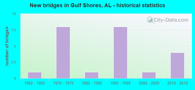
- New bridges - historical statistics
- 11960-1969
- 81970-1979
- 11980-1989
- 81990-1999
- 12000-2009
- 42010-2019
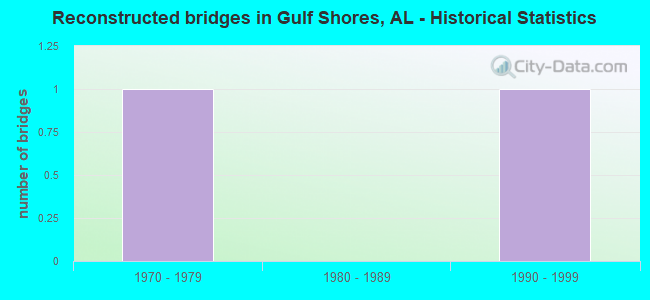
- Reconstructed bridges - Historical Statistics
- 11970-1979
- 01980-1989
- 11990-1999
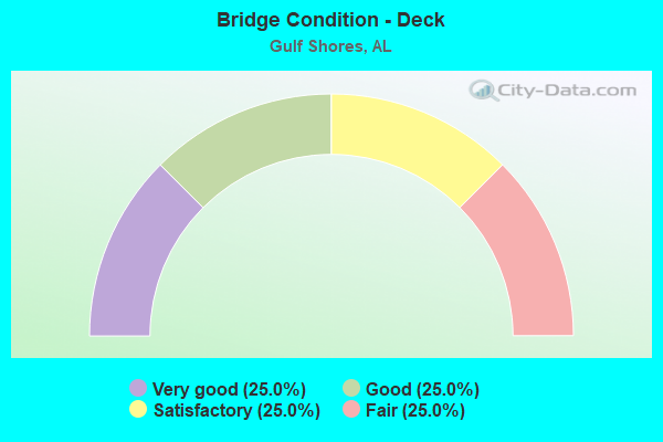
- Bridge Condition - Deck
- 25.0%Very good
- 25.0%Good
- 25.0%Satisfactory
- 25.0%Fair
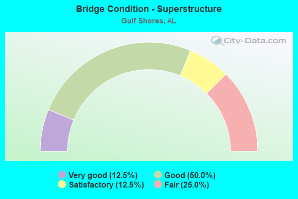
- Bridge Condition - Superstructure
- 12.5%Very good
- 50.0%Good
- 12.5%Satisfactory
- 25.0%Fair
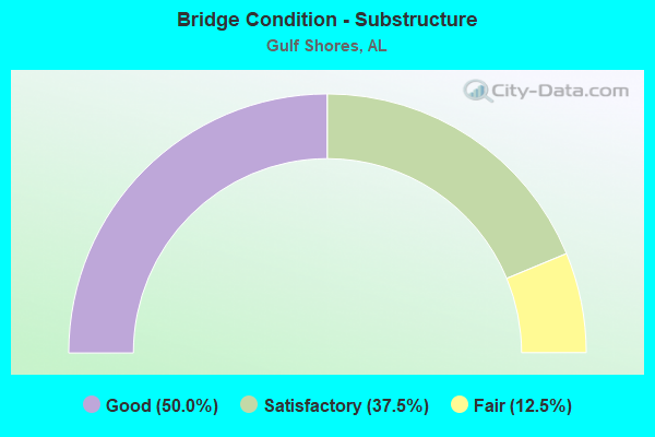
- Bridge Condition - Substructure
- 50.0%Good
- 37.5%Satisfactory
- 12.5%Fair
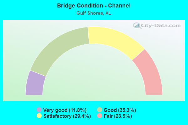
- Bridge Condition - Channel
- 11.8%Very good
- 35.3%Good
- 29.4%Satisfactory
- 23.5%Fair
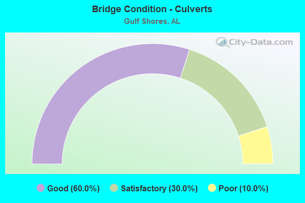
- Bridge Condition - Culverts
- 60.0%Good
- 30.0%Satisfactory
- 10.0%Poor
Find on map >> Show street view
Structure Number: 1834, Location: 4170 FT N JCT 1073 (Lat: 34.242458, Lng: -86.314342), Route carried "on" structure: County highway 159, Year Built: 1960, Status: Posted for load, Structure Length: 0.98m (3.22ft), Average Daily Traffic: 200 (year 1994), Truck Traffic: 1%, Average Future Daily Traffic: 350 (year 2040), Design Load: H 10, Features Intersected: SLAB CREEK, Facility Carried by Structure: COUNTY HIGHWAY115
Minimum Vertical Clearance: 30+ m (98+ ft), Kilometerpoint: 0.010, Lanes on structure: 2, Owner: County Highway Agency, Approaching Roadway Width: 7.9m (25.9ft), Skew: 3 degrees, Material/Design: Concrete, Design/Construction: Culvert, Number Of Spans In Main Unit: 2, Length of Maximum Span: 3.7m (12.1ft)
Condition: Channel: Fair, Culverts: Poor, Operating Rating: 13.6 metric tons, Method Used To Determine Operating Rating: Load Factor (LF), Inventory Rating: 11.8 metric tons, Method Used To Determine Inventory Rating: Load Factor (LF), Structural Evaluation: Meets minimum limits, Waterway Adequacy: Meets minimum limits, Approach Roadway Alignment: Superior to present desirable criteria, Bridge Posting: Required (Relationship of Operating Rating to Maximum Legal Load: > 39.9% below), Length Of Structure Improvement: 1.65m (5.41ft), Designated Inspection Frequency: Every 24 months, Other Special Inspection Frequency: Every 12 months, Inspection Date: June 2020, Other Special Inspection Date: June 2021, Bridge Improvement Cost: $248,000, Roadway Improvement Cost: $25,000, Total Project Cost: $273,000 ( Estimate for 2022), Wearing Surface/Protective System: Wearing Surface: Gravel
Find on map >> Show street view
Structure Number: 10764, Location: 1.8 MI N SR 182 (Lat: 30.275511, Lng: -87.687008), Route carried "on" structure: State highway 59, Year Built: 1972, Status: Open, Structure Length: 5.33m (17.49ft), Average Daily Traffic: 44,604 (year 2019), Truck Traffic: 6%, Average Future Daily Traffic: 66,906 (year 2039), Design Load: HS 20, Features Intersected: 22ND AVE
Minimum Vertical Clearance: 30+ m (98+ ft), Kilometerpoint: 3.000, Lanes on structure: 5, Lanes under structure: 2, Base Highway Network: Yes, Owner: State Highway Agency, Approaching Roadway Width: 25.0m (82.0ft), Skew: 20 degrees, Material/Design: Steel, Design/Construction: Stringer/Multi-beam, Number Of Spans In Main Unit: 3, Length of Maximum Span: 21.3m (69.9ft), Curb-To-Curb Width: 24.7m (81.0ft), Out-to-Out Width: 25.8m (84.6ft)
Condition: Deck: Satisfactory, Superstructure: Good, Substructure: Good, Operating Rating: 68.7 metric tons, Method Used To Determine Operating Rating: Load Factor (LF), Inventory Rating: 41.1 metric tons, Method Used To Determine Inventory Rating: Load Factor (LF), Structural Evaluation: Better than present minimum criteria, Deck Geometry: Superior to present desirable criteria, Underclear: Meets minimum limits, Approach Roadway Alignment: Better than present minimum criteria, Length Of Structure Improvement: 6.36m (20.87ft), Designated Inspection Frequency: Every 24 months, Inspection Date: December 2020, Bridge Improvement Cost: $3,665,000, Roadway Improvement Cost: $367,000, Total Project Cost: $4,032,000 ( Estimate for 2022), Deck Structure Type: Concrete Cast-file-Place
Find on map >> Show street view
Structure Number: 1125, Location: 1 MI S JCT CO RD 10 (Lat: 30.321728, Lng: -87.683000), Route carried "on" structure: State highway 59, Year Built: 1974, Status: Open, Structure Length: 0.70m (2.30ft), Average Daily Traffic: 34,496 (year 2020), Truck Traffic: 6%, Average Future Daily Traffic: 51,744 (year 2040), Design Load: HS 20, Features Intersected: BRIGHTS CREEK
Minimum Vertical Clearance: 30+ m (98+ ft), Kilometerpoint: 8.206, Lanes on structure: 5, Base Highway Network: Yes, Owner: State Highway Agency, Approaching Roadway Width: 24.0m (78.7ft), Skew: 14 degrees, Material/Design: Concrete, Design/Construction: Culvert, Number Of Spans In Main Unit: 2, Length of Maximum Span: 2.1m (6.9ft)
Condition: Channel: Fair, Culverts: Satisfactory, Operating Rating: 88.9 metric tons, Method Used To Determine Operating Rating: Load Factor (LF), Inventory Rating: 79.1 metric tons, Method Used To Determine Inventory Rating: Load Factor (LF), Structural Evaluation: Equal to present minimum criteria, Waterway Adequacy: Equal to present minimum criteria, Approach Roadway Alignment: Equal to present desirable criteria, Length Of Structure Improvement: 1.34m (4.40ft), Designated Inspection Frequency: Every 24 months, Underwater Inspection Frequency: Every 24 months, Inspection Date: November 2021, Underwater Inspection Date: November 2021, Bridge Improvement Cost: $1,500,000, Roadway Improvement Cost: $150,000, Total Project Cost: $1,650,000 ( Estimate for 2022)
Find on map >> Show street view
Structure Number: 11464, Location: .4 MI N JCT SR 182 (Lat: 30.254694, Lng: -87.688811), Route carried "on" structure: State highway 59, Year Built: 1975, Status: Open, Structure Length: 5.18m (16.99ft), Average Daily Traffic: 38,400 (year 2019), Truck Traffic: 6%, Average Future Daily Traffic: 57,600 (year 2039), Design Load: HS 20, Features Intersected: LITTLE LAGOON
Minimum Vertical Clearance: 30+ m (98+ ft), Kilometerpoint: 0.705, Lanes on structure: 4, Base Highway Network: Yes, Owner: State Highway Agency, Approaching Roadway Width: 15.8m (51.8ft), Skew: 20 degrees, Material/Design: Prestressed concrete continuous, Design/Construction: Stringer/Multi-beam, Number Of Spans In Main Unit: 5, Length of Maximum Span: 10.4m (34.1ft), Curb or Sidewalk Widths: Left: 2.4m (7.9ft), Right: 2.4m (7.9ft), Curb-To-Curb Width: 15.8m (51.8ft), Out-to-Out Width: 19.4m (63.6ft)
Condition: Deck: Fair, Superstructure: Satisfactory, Substructure: Satisfactory, Channel: Good, Operating Rating: 71.2 metric tons, Method Used To Determine Operating Rating: Load Factor (LF), Inventory Rating: 42.7 metric tons, Method Used To Determine Inventory Rating: Load Factor (LF), Structural Evaluation: Equal to present minimum criteria, Deck Geometry: Meets minimum limits, Waterway Adequacy: Equal to present minimum criteria, Approach Roadway Alignment: Equal to present desirable criteria, Length Of Structure Improvement: 6.21m (20.37ft), Designated Inspection Frequency: Every 24 months, Underwater Inspection Frequency: Every 24 months, Inspection Date: December 2020, Underwater Inspection Date: November 2021, Bridge Improvement Cost: $2,681,000, Roadway Improvement Cost: $268,000, Total Project Cost: $2,949,000 ( Estimate for 2022), Deck Structure Type: Concrete Cast-file-Place
Find on map >> Show street view
Structure Number: 11551, Location: 1.9 MI N SR 182 (Lat: 30.277031, Lng: -87.686814), Route carried "on" structure: State highway 59, Year Built: 1972, Year Reconstructed: 1976, Status: Open, Structure Length: 53.71m (176.21ft), Average Daily Traffic: 44,604 (year 2019), Truck Traffic: 6%, Average Future Daily Traffic: 66,906 (year 2039), Design Load: HS 20, Features Intersected: INTRACOASTAL CANAL
Minimum Vertical Clearance: 30+ m (98+ ft), Kilometerpoint: 3.188, Lanes on structure: 5, Lanes under structure: 4, Base Highway Network: Yes, Owner: State Highway Agency, Approaching Roadway Width: 25.0m (82.0ft), Skew: 30 degrees, Navigation Control: Yes ( Vertical Clearance: 22.3m (73.2ft), Horizontal Clearance: 38.1m (125.0ft)), Material/Design: Steel continuous, Design/Construction: Stringer/Multi-beam, Number Of Spans In Main Unit: 13, Length of Maximum Span: 54.9m (180.1ft), Curb-To-Curb Width: 24.7m (81.0ft), Out-to-Out Width: 25.8m (84.6ft)
Condition: Deck: Fair, Superstructure: Fair, Substructure: Satisfactory, Channel: Fair, Operating Rating: 56.4 metric tons, Method Used To Determine Operating Rating: Load Factor (LF), Inventory Rating: 33.8 metric tons, Method Used To Determine Inventory Rating: Load Factor (LF), Structural Evaluation: Somewhat better than minimum adequacy, Deck Geometry: Superior to present desirable criteria, Underclear: High priority of corrective action, Waterway Adequacy: Superior to present desirable criteria, Approach Roadway Alignment: Equal to present desirable criteria, Length Of Structure Improvement: 53.71m (176.21ft), Designated Inspection Frequency: Every 24 months, Critical Feature Inspection Frequency: Every 24 months, Underwater Inspection Frequency: Every 24 months, Inspection Date: May 2021, Critical Feature Inspection Date: May 2021, Underwater Inspection Date: Febuary 2022, Bridge Improvement Cost: $30,934,000, Roadway Improvement Cost: $3,093,000, Total Project Cost: $34,027,000 ( Estimate for 2022), Deck Structure Type: Concrete Cast-file-Place
Find on map >> Show street view
Structure Number: 15042, Location: E OF GU SH POST OFFICE (Lat: 30.274486, Lng: -87.683894), Route carried "on" structure: City street , Year Built: 1988, Status: Open, Structure Length: 0.76m (2.49ft), Average Daily Traffic: 488 (year 2021), Truck Traffic: 1%, Average Future Daily Traffic: 732 (year 2041), Features Intersected: W 1ST ST DRAINAGE, Facility Carried by Structure: W 21ST AVE
Minimum Vertical Clearance: 30+ m (98+ ft), Kilometerpoint: 0.000, Lanes on structure: 2, Owner: City or Municipal Highway Agency, Approaching Roadway Width: 8.5m (27.9ft), Material/Design: Concrete, Design/Construction: Culvert, Number Of Spans In Main Unit: 3, Length of Maximum Span: 2.4m (7.9ft), Curb-To-Curb Width: 8.5m (27.9ft), Out-to-Out Width: 16.5m (54.1ft)
Condition: Channel: Good, Culverts: Satisfactory, Operating Rating: 43.7 metric tons, Method Used To Determine Operating Rating: Load Factor (LF), Inventory Rating: 26.2 metric tons, Method Used To Determine Inventory Rating: Load Factor (LF), Structural Evaluation: Equal to present minimum criteria, Deck Geometry: Somewhat better than minimum adequacy, Waterway Adequacy: Equal to present desirable criteria, Approach Roadway Alignment: Equal to present desirable criteria, Length Of Structure Improvement: 1.41m (4.63ft), Designated Inspection Frequency: Every 24 months, Inspection Date: Febuary 2021, Bridge Improvement Cost: $433,000, Roadway Improvement Cost: $43,000, Total Project Cost: $476,000 ( Estimate for 2022)
Find on map >> Show street view
Structure Number: 15234, Location: 0.1 MI S CLUBHOUSE DR (Lat: 30.263333, Lng: -87.688333), Route carried "on" structure: City street , Year Built: 1990, Status: Open, Structure Length: 0.78m (2.56ft), Average Daily Traffic: 697 (year 2021), Truck Traffic: 1%, Average Future Daily Traffic: 1,046 (year 2041), Features Intersected: WEST 1ST ST DRAINAGE, Facility Carried by Structure: WEST 2ND ST
Minimum Vertical Clearance: 30+ m (98+ ft), Kilometerpoint: 0.526, Lanes on structure: 2, Owner: City or Municipal Highway Agency, Approaching Roadway Width: 6.7m (22.0ft), Skew: 1 degrees, Material/Design: Concrete, Design/Construction: Culvert, Number Of Spans In Main Unit: 2, Length of Maximum Span: 3.1m (10.2ft), Curb or Sidewalk Widths: Left: 0.0m, Right: 2.1m (6.9ft)
Condition: Channel: Satisfactory, Culverts: Good, Operating Rating: 82.2 metric tons, Method Used To Determine Operating Rating: Load Factor (LF), Inventory Rating: 49.4 metric tons, Method Used To Determine Inventory Rating: Load Factor (LF), Structural Evaluation: Better than present minimum criteria, Waterway Adequacy: Better than present minimum criteria, Approach Roadway Alignment: Equal to present desirable criteria, Length Of Structure Improvement: 1.43m (4.69ft), Designated Inspection Frequency: Every 24 months, Inspection Date: Febuary 2021, Bridge Improvement Cost: $339,000, Roadway Improvement Cost: $34,000, Total Project Cost: $373,000 ( Estimate for 2022)
Find on map >> Show street view
Structure Number: 15235, Location: 192' W OF SR 59 (Lat: 30.271028, Lng: -87.688683), Route carried "on" structure: City street , Year Built: 1990, Year Reconstructed: 1996, Status: Open, Structure Length: 0.76m (2.49ft), Average Daily Traffic: 1,220 (year 2021), Truck Traffic: 2%, Average Future Daily Traffic: 1,830 (year 2041), Features Intersected: WEST 1ST ST. DRAINAGE, Facility Carried by Structure: CLUBHOUSE DRIVE
Minimum Vertical Clearance: 30+ m (98+ ft), Kilometerpoint: 0.702, Lanes on structure: 2, Owner: City or Municipal Highway Agency, Approaching Roadway Width: 6.1m (20.0ft), Material/Design: Concrete, Design/Construction: Culvert, Number Of Spans In Main Unit: 3, Length of Maximum Span: 2.4m (7.9ft)
Condition: Channel: Fair, Culverts: Satisfactory, Operating Rating: 88.9 metric tons, Method Used To Determine Operating Rating: Load Factor (LF), Inventory Rating: 56.9 metric tons, Method Used To Determine Inventory Rating: Load Factor (LF), Structural Evaluation: Equal to present minimum criteria, Waterway Adequacy: Better than present minimum criteria, Approach Roadway Alignment: Equal to present desirable criteria, Length Of Structure Improvement: 1.41m (4.63ft), Designated Inspection Frequency: Every 24 months, Inspection Date: Febuary 2021, Bridge Improvement Cost: $2,390,000, Roadway Improvement Cost: $239,000, Total Project Cost: $2,629,000 ( Estimate for 2022)
Find on map >> Show street view
Structure Number: 15236, Location: 321' W OF SR 59 (Lat: 30.272464, Lng: -87.685597), Route carried "on" structure: City street , Year Built: 1990, Status: Open, Structure Length: 0.76m (2.49ft), Average Daily Traffic: 1,220 (year 2021), Truck Traffic: 2%, Average Future Daily Traffic: 1,830 (year 2041), Features Intersected: W 1ST ST DRAINAGE, Facility Carried by Structure: W 19TH AVE
Minimum Vertical Clearance: 30+ m (98+ ft), Kilometerpoint: 0.428, Lanes on structure: 2, Owner: City or Municipal Highway Agency, Approaching Roadway Width: 7.5m (24.6ft), Material/Design: Concrete, Design/Construction: Culvert, Number Of Spans In Main Unit: 3, Length of Maximum Span: 2.4m (7.9ft), Curb or Sidewalk Widths: Left: 1.8m (5.9ft), Right: 0.0m
Condition: Channel: Satisfactory, Culverts: Good, Operating Rating: 88.9 metric tons, Method Used To Determine Operating Rating: Load Factor (LF), Inventory Rating: 59.3 metric tons, Method Used To Determine Inventory Rating: Load Factor (LF), Structural Evaluation: Better than present minimum criteria, Waterway Adequacy: Better than present minimum criteria, Approach Roadway Alignment: Equal to present desirable criteria, Length Of Structure Improvement: 1.41m (4.63ft), Designated Inspection Frequency: Every 24 months, Inspection Date: Febuary 2021, Bridge Improvement Cost: $441,000, Roadway Improvement Cost: $44,000, Total Project Cost: $485,000 ( Estimate for 2022)
Find on map >> Show street view
Structure Number: 15237, Location: 0.3 MI W OF E 2ND ST (Lat: 30.275558, Lng: -87.688742), Route carried "on" structure: City street , Year Built: 1990, Status: Open, Structure Length: 1.26m (4.13ft), Average Daily Traffic: 731 (year 2021), Truck Traffic: 1%, Average Future Daily Traffic: 1,097 (year 2041), Features Intersected: W 1ST ST DRAINAGE, Facility Carried by Structure: W 22ND AVE
Minimum Vertical Clearance: 30+ m (98+ ft), Kilometerpoint: 0.628, Lanes on structure: 2, Owner: City or Municipal Highway Agency, Approaching Roadway Width: 9.8m (32.2ft), Material/Design: Concrete, Design/Construction: Culvert, Number Of Spans In Main Unit: 4, Length of Maximum Span: 3.0m (9.8ft)
Condition: Channel: Good, Culverts: Good, Operating Rating: 50.4 metric tons, Method Used To Determine Operating Rating: Load Factor (LF), Inventory Rating: 30.2 metric tons, Method Used To Determine Inventory Rating: Load Factor (LF), Structural Evaluation: Better than present minimum criteria, Waterway Adequacy: Better than present minimum criteria, Approach Roadway Alignment: Equal to present desirable criteria, Length Of Structure Improvement: 1.94m (6.36ft), Designated Inspection Frequency: Every 24 months, Inspection Date: Febuary 2021, Bridge Improvement Cost: $605,000, Roadway Improvement Cost: $61,000, Total Project Cost: $666,000 ( Estimate for 2022)
Find on map >> Show street view
Structure Number: 15238, Location: 0.3 MI W OF E 2ND ST (Lat: 30.277939, Lng: -87.688756), Route carried "on" structure: City street , Year Built: 1990, Status: Open, Structure Length: 1.26m (4.13ft), Average Daily Traffic: 490 (year 2021), Truck Traffic: 1%, Average Future Daily Traffic: 733 (year 2041), Features Intersected: W 1ST ST DRAINAGE, Facility Carried by Structure: W CANAL AVE
Minimum Vertical Clearance: 30+ m (98+ ft), Kilometerpoint: 1.629, Lanes on structure: 2, Owner: City or Municipal Highway Agency, Approaching Roadway Width: 6.1m (20.0ft), Material/Design: Concrete, Design/Construction: Culvert, Number Of Spans In Main Unit: 4, Length of Maximum Span: 3.0m (9.8ft), Curb or Sidewalk Widths: Left: 1.5m (4.9ft), Right: 0.0m, Curb-To-Curb Width: 6.1m (20.0ft), Out-to-Out Width: 16.6m (54.5ft)
Condition: Channel: Satisfactory, Culverts: Good, Operating Rating: 40.0 metric tons, Method Used To Determine Operating Rating: Load Factor (LF), Inventory Rating: 23.9 metric tons, Method Used To Determine Inventory Rating: Load Factor (LF), Structural Evaluation: Equal to present minimum criteria, Deck Geometry: High priority of corrective action, Waterway Adequacy: Better than present minimum criteria, Approach Roadway Alignment: Equal to present desirable criteria, Length Of Structure Improvement: 1.94m (6.36ft), Designated Inspection Frequency: Every 24 months, Inspection Date: Febuary 2021, Bridge Improvement Cost: $605,000, Roadway Improvement Cost: $61,000, Total Project Cost: $666,000 ( Estimate for 2022)
Find on map >> Show street view
Structure Number: 16843, Location: 4.3 MI. W. OF AL. HWY. 59 (Lat: 30.283436, Lng: -87.734317), Route carried "on" structure: County highway 6, Year Built: 1997, Status: Open, Structure Length: 5.18m (16.99ft), Average Daily Traffic: 977 (year 2019), Truck Traffic: 1%, Average Future Daily Traffic: 1,466 (year 2039), Design Load: HS 20, Features Intersected: OYSTER BAY
Minimum Vertical Clearance: 30+ m (98+ ft), Kilometerpoint: 0.014, Lanes on structure: 2, Owner: County Highway Agency, Approaching Roadway Width: 12.2m (40.0ft), Material/Design: Concrete, Design/Construction: Channel Beam, Number Of Spans In Main Unit: 5, Length of Maximum Span: 10.4m (34.1ft), Curb-To-Curb Width: 8.6m (28.2ft), Out-to-Out Width: 9.3m (30.5ft)
Condition: Deck: Good, Superstructure: Good, Substructure: Good, Channel: Good, Operating Rating: 54.9 metric tons, Method Used To Determine Operating Rating: Load Factor (LF), Inventory Rating: 32.8 metric tons, Method Used To Determine Inventory Rating: Load Factor (LF), Structural Evaluation: Better than present minimum criteria, Deck Geometry: Somewhat better than minimum adequacy, Waterway Adequacy: Better than present minimum criteria, Approach Roadway Alignment: High priority of corrective action, Length Of Structure Improvement: 6.21m (20.37ft), Designated Inspection Frequency: Every 24 months, Underwater Inspection Frequency: Every 48 months, Inspection Date: March 2021, Underwater Inspection Date: October 2020, Bridge Improvement Cost: $1,277,000, Roadway Improvement Cost: $128,000, Total Project Cost: $1,405,000 ( Estimate for 2022), Deck Structure Type: Concrete Precast Panels
Find on map >> Show street view
Structure Number: 17925, Location: 2.3 MI. E. OF AL. HWY. 59 (Lat: 30.297525, Lng: -87.644928), Route carried "on" structure: County highway 4, Year Built: 2000, Status: Open, Structure Length: 2.08m (6.82ft), Average Daily Traffic: 405 (year 2018), Truck Traffic: 1%, Average Future Daily Traffic: 547 (year 2038), Features Intersected: COTTON CREEK
Minimum Vertical Clearance: 7.56m (24.80ft), Kilometerpoint: 0.010, Lanes on structure: 2, Owner: County Highway Agency, Approaching Roadway Width: 8.5m (27.9ft), Material/Design: Concrete, Design/Construction: Channel Beam, Number Of Spans In Main Unit: 2, Length of Maximum Span: 10.4m (34.1ft), Curb-To-Curb Width: 9.4m (30.8ft), Out-to-Out Width: 10.2m (33.5ft)
Condition: Deck: Good, Superstructure: Very good, Substructure: Good, Channel: Very good, Operating Rating: 51.8 metric tons, Method Used To Determine Operating Rating: Load Factor (LF), Inventory Rating: 31.0 metric tons, Method Used To Determine Inventory Rating: Load Factor (LF), Structural Evaluation: Better than present minimum criteria, Deck Geometry: Equal to present minimum criteria, Waterway Adequacy: Better than present minimum criteria, Approach Roadway Alignment: Equal to present desirable criteria, Length Of Structure Improvement: 2.85m (9.35ft), Designated Inspection Frequency: Every 24 months, Underwater Inspection Frequency: Every 48 months, Inspection Date: October 2020, Underwater Inspection Date: October 2019, Bridge Improvement Cost: $644,000, Roadway Improvement Cost: $64,000, Total Project Cost: $708,000 ( Estimate for 2022), Deck Structure Type: Concrete Precast Panels
Find on map >> Show street view
Structure Number: 18205, Location: 0.2 MI N SR 182 (Lat: 30.256122, Lng: -87.653814), Route carried "on" structure: State lands road 2, Year Built: 1975, Status: Open, Structure Length: 4.88m (16.01ft), Average Daily Traffic: 185 (year 2019), Truck Traffic: 1%, Average Future Daily Traffic: 278 (year 2039), Design Load: HS 20, Features Intersected: GULF ST PARK BOAT CANAL
Minimum Vertical Clearance: 30+ m (98+ ft), Kilometerpoint: 4.345, Lanes on structure: 2, Owner: State Park, Forest, or Reservation Agency, Maintenance Responsibility: State Highway Agency, Approaching Roadway Width: 9.1m (29.9ft), Skew: 11 degrees, Material/Design: Prestressed concrete, Design/Construction: Box Beam or Girders - Multiple, Number Of Spans In Main Unit: 4, Length of Maximum Span: 12.2m (40.0ft), Curb or Sidewalk Widths: Left: 1.6m (5.2ft), Right: 1.8m (5.9ft), Curb-To-Curb Width: 7.3m (24.0ft), Out-to-Out Width: 12.2m (40.0ft)
Condition: Deck: Satisfactory, Superstructure: Fair, Substructure: Fair, Channel: Satisfactory, Operating Rating: 72.5 metric tons, Method Used To Determine Operating Rating: Load Factor (LF), Inventory Rating: 43.4 metric tons, Method Used To Determine Inventory Rating: Load Factor (LF), Structural Evaluation: Somewhat better than minimum adequacy, Deck Geometry: Somewhat better than minimum adequacy, Waterway Adequacy: Equal to present minimum criteria, Approach Roadway Alignment: Equal to present desirable criteria, Length Of Structure Improvement: 5.89m (19.32ft), Designated Inspection Frequency: Every 24 months, Underwater Inspection Frequency: Every 24 months, Inspection Date: April 2021, Underwater Inspection Date: May 2021, Bridge Improvement Cost: $1,615,000, Roadway Improvement Cost: $162,000, Total Project Cost: $1,777,000 ( Estimate for 2022), Deck Structure Type: Concrete Precast Panels, Wearing Surface/Protective System: Wearing Surface: Bituminous
Find on map >> Show street view
Structure Number: 1834, Location: 1 MI W 29TH AVE (Lat: 30.282747, Lng: -87.704361), Route carried "on" structure: City street , Year Built: 1999, Status: Open, Structure Length: 0.63m (2.07ft), Average Daily Traffic: 630 (year 2021), Truck Traffic: 1%, Average Future Daily Traffic: 945 (year 2041), Design Load: HS 20, Features Intersected: 28TH AVE DRAINAGE, Facility Carried by Structure: 28TH AVE
Minimum Vertical Clearance: 30+ m (98+ ft), Kilometerpoint: 0.000, Lanes on structure: 2, Owner: City or Municipal Highway Agency, Approaching Roadway Width: 5.8m (19.0ft), Material/Design: Concrete, Design/Construction: Culvert, Number Of Spans In Main Unit: 2, Length of Maximum Span: 3.0m (9.8ft)
Condition: Channel: Good, Culverts: Good, Operating Rating: 88.9 metric tons, Method Used To Determine Operating Rating: Load Factor (LF), Inventory Rating: 60.1 metric tons, Method Used To Determine Inventory Rating: Load Factor (LF), Structural Evaluation: Better than present minimum criteria, Waterway Adequacy: Better than present minimum criteria, Approach Roadway Alignment: Equal to present desirable criteria, Length Of Structure Improvement: 1.25m (4.10ft), Designated Inspection Frequency: Every 24 months, Inspection Date: Febuary 2021, Bridge Improvement Cost: $377,000, Roadway Improvement Cost: $38,000, Total Project Cost: $415,000 ( Estimate for 2022)
Find on map >> Show street view
Structure Number: 20631, Location: 1 Mile West Of SR 59 (Lat: 30.241394, Lng: -87.738172), Route carried "on" structure: State highway 182, Year Built: 2015, Status: Open, Structure Length: 5.82m (19.09ft), Average Daily Traffic: 6,068 (year 2019), Truck Traffic: 2%, Average Future Daily Traffic: 9,102 (year 2039), Design Load: HS 20, Features Intersected: LITTLE LAGOON PASS
Minimum Vertical Clearance: 30+ m (98+ ft), Kilometerpoint: 5.681, Lanes on structure: 2, Owner: State Highway Agency, Approaching Roadway Width: 7.9m (25.9ft), Material/Design: Prestressed concrete continuous, Design/Construction: Stringer/Multi-beam, Number Of Spans In Main Unit: 3, Length of Maximum Span: 25.1m (82.3ft), Curb-To-Curb Width: 7.3m (24.0ft), Out-to-Out Width: 12.6m (41.3ft)
Condition: Deck: Very good, Superstructure: Good, Substructure: Good, Channel: Good, Operating Rating: 82.0 metric tons, Method Used To Determine Operating Rating: Load Factor (LF), Inventory Rating: 49.1 metric tons, Method Used To Determine Inventory Rating: Load Factor (LF), Structural Evaluation: Better than present minimum criteria, Deck Geometry: High priority of replacement, Waterway Adequacy: Better than present minimum criteria, Approach Roadway Alignment: Equal to present desirable criteria, Length Of Structure Improvement: 6.86m (22.51ft), Designated Inspection Frequency: Every 24 months, Underwater Inspection Frequency: Every 24 months, Inspection Date: April 2021, Underwater Inspection Date: December 2020, Bridge Improvement Cost: $1,929,000, Roadway Improvement Cost: $193,000, Total Project Cost: $2,122,000 ( Estimate for 2022), Deck Structure Type: Concrete Cast-file-Place
Find on map >> Show street view
Structure Number: 21549, Location: _0.9 MI N SR 182 (Lat: 30.256325, Lng: -87.679042), Route carried "on" structure: State highway 135, Year Built: 2019, Status: Open, Structure Length: 1.46m (4.79ft), Average Daily Traffic: 10,151 (year 2020), Truck Traffic: 2%, Average Future Daily Traffic: 15,227 (year 2040), Design Load: HS 20, Features Intersected: _SALT LAKE CHANNEL
Minimum Vertical Clearance: 30+ m (98+ ft), Kilometerpoint: 1.455, Lanes on structure: 2, Owner: State Agenciy, Approaching Roadway Width: 11.4m (37.4ft), Material/Design: Concrete, Design/Construction: Channel Beam, Number Of Spans In Main Unit: 2, Length of Maximum Span: 7.3m (24.0ft), Curb-To-Curb Width: 12.3m (40.4ft), Out-to-Out Width: 13.0m (42.7ft)
Condition: Deck: Very good, Superstructure: Good, Substructure: Satisfactory, Channel: Satisfactory, Operating Rating: 84.1 metric tons, Method Used To Determine Operating Rating: Load Factor (LF), Inventory Rating: 50.4 metric tons, Method Used To Determine Inventory Rating: Load Factor (LF), Structural Evaluation: Equal to present minimum criteria, Deck Geometry: Somewhat better than minimum adequacy, Waterway Adequacy: Superior to present desirable criteria, Approach Roadway Alignment: Equal to present minimum criteria, Length Of Structure Improvement: 2.14m (7.02ft), Designated Inspection Frequency: Every 24 months, Underwater Inspection Frequency: Every 24 months, Inspection Date: December 2021, Underwater Inspection Date: January 2022, Bridge Improvement Cost: $617,000, Roadway Improvement Cost: $62,000, Total Project Cost: $679,000 ( Estimate for 2022), Deck Structure Type: Concrete Precast Panels, Wearing Surface/Protective System: Wearing Surface: Bituminous
Find on map >> Show street view
Structure Number: 21553, Location: 189 ft south of HWY 180. (Lat: 30.235833, Lng: -87.916389), Route carried "on" structure: County highway , Year Built: 1992, Status: Open, Structure Length: 1.83m (6.00ft), Average Daily Traffic: 50 (year 2020), Average Future Daily Traffic: 100 (year 2040), Design Load: HS 20, Features Intersected: UNNAMED CREEK, Facility Carried by Structure: MORGANTOWN BLVD
Minimum Vertical Clearance: 30+ m (98+ ft), Kilometerpoint: 0.010, Lanes on structure: 2, Owner: County Highway Agency, Approaching Roadway Width: 10.4m (34.1ft), Material/Design: Concrete, Design/Construction: Culvert, Number Of Spans In Main Unit: 10, Length of Maximum Span: 1.5m (4.9ft), Out-to-Out Width: 11.6m (38.1ft)
Condition: Channel: Very good, Culverts: Good, Operating Rating: 43.5 metric tons, Method Used To Determine Operating Rating: Field evaluation and documented engineering judgment, Inventory Rating: 32.7 metric tons, Method Used To Determine Inventory Rating: Field evaluation and documented engineering judgment, Structural Evaluation: Better than present minimum criteria, Waterway Adequacy: Equal to present desirable criteria, Approach Roadway Alignment: Equal to present desirable criteria, Length Of Structure Improvement: 2.54m (8.33ft), Designated Inspection Frequency: Every 24 months, Inspection Date: Febuary 2022, Bridge Improvement Cost: $558,000, Roadway Improvement Cost: $56,000, Total Project Cost: $614,000 ( Estimate for 2022), Deck Structure Type: Concrete Cast-file-Place, Wearing Surface/Protective System: Wearing Surface: Monolithic Concrete
Find on map >> Show street view
Structure Number: 10764, Location: 1.8 MI N SR 182 (Lat: 30.275511, Lng: -87.687008), Route carried "under" structure: City street , Year Built: 1972, Structure Length: 0. m, Average Daily Traffic: 955 (year 2019), Truck Traffic: 1%, Features Intersected: 22ND AVE, Facility Carried by Structure: SR 59
Minimum Vertical Clearance: 5.19m (17.03ft), Kilometerpoint: 0.000, Lanes on structure: 5, Lanes under structure: 2, Material/Design: Steel, Design/Construction: Stringer/Multi-beam, Length of Maximum Span: 21.3m (69.9ft)
Find on map >> Show street view
Structure Number: 11551, Location: 1.9 MI N SR 182 (Lat: 30.277031, Lng: -87.686814), Route carried "under" structure: City street , Year Built: 1972, Structure Length: 0. m, Average Daily Traffic: 700 (year 2019), Truck Traffic: 1%, Features Intersected: INTRACOASTAL CANAL, Facility Carried by Structure: SR 59
Minimum Vertical Clearance: 11.89m (39.01ft), Kilometerpoint: 0.000, Lanes on structure: 5, Lanes under structure: 2, Material/Design: Steel continuous, Design/Construction: Stringer/Multi-beam, Length of Maximum Span: 54.9m (180.1ft)
Find on map >> Show street view
Structure Number: 11551, Location: 1.9 MI N SR 182 (Lat: 30.277031, Lng: -87.686814), Route carried "under" structure: City street , Year Built: 1972, Structure Length: 0. m, Average Daily Traffic: 600 (year 2019), Truck Traffic: 1%, Features Intersected: INTRACOASTAL CANAL, Facility Carried by Structure: SR 59
Minimum Vertical Clearance: 11.89m (39.01ft), Kilometerpoint: 0.000, Lanes on structure: 5, Lanes under structure: 2, Material/Design: Steel continuous, Design/Construction: Stringer/Multi-beam, Length of Maximum Span: 54.9m (180.1ft)
Find on map >> Show street view
Structure Number: 21394, Location: .1 Mi. E. Of SR-135 & 182 (Lat: 30.251875, Lng: -87.664794), Route carried "under" structure: State highway 182, Year Built: 2017, Structure Length: 0. m, Average Daily Traffic: 21,670 (year 2017), Truck Traffic: 3%, Features Intersected: SR-182, Facility Carried by Structure: Ped. O'pass @ Pier
Minimum Vertical Clearance: 5.49m (18.01ft), Kilometerpoint: 12.826, Lanes under structure: 5, Material/Design: Steel, Design/Construction: Truss - Thru, Length of Maximum Span: 42.7m (140.1ft)
Find on map >> Show street view
Structure Number: 21399, Location: _ (Lat: 30.255419, Lng: -87.644697), Route carried "under" structure: State highway 182, Year Built: 2017, Structure Length: 0. m, Average Daily Traffic: 17,440 (year 2017), Truck Traffic: 3%, Features Intersected: SR-182, Facility Carried by Structure: Ped Opass @ Pavil
Minimum Vertical Clearance: 5.36m (17.59ft), Kilometerpoint: 14.886, Lanes under structure: 5, Material/Design: Steel, Design/Construction: Truss - Thru, Length of Maximum Span: 0.0m