Bridge Statistics for Groesbeck, Ohio (OH)
Condition, Traffic, Stress, Structural Evaluation, Project Costs
- National Bridge Inventory (NBI) Statistics
- 27Number of bridges
- 279ft / 85.4mTotal length
- 500,595Total average daily traffic
- 32,370Total average daily truck traffic
- National Bridge Inventory (NBI) Registered Bridges for Groesbeck
- No street view available for this location
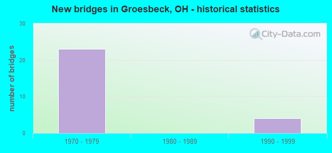
- New bridges - historical statistics
- 231970-1979
- 41990-1999


- Bridge Condition - Deck
- 6.7%Excellent
- 26.7%Very good
- 60.0%Good
- 6.7%Satisfactory

- Bridge Condition - Superstructure
- 13.3%Very good
- 86.7%Good

- Bridge Condition - Substructure
- 13.3%Very good
- 86.7%Good

- Bridge Condition - Channel
- 66.7%Very good
- 33.3%Satisfactory
Find on map >> Show street view
Structure Number: 3104575, Location: 0.9 MILES EAST OF US 27 (Lat: 39.224719, Lng: -84.575231), Route carried "on" structure: State highway 126, Year Built: 1996, Status: Open, Structure Length: 4.27m (14.01ft), Average Daily Traffic: 16,342 (year 2015), Truck Traffic: 4%, Average Future Daily Traffic: 22,683 (year 2035), Design Load: HS 20+Mod, Features Intersected: WEST FORK OF MILL CREEK
Minimum Vertical Clearance: 30+ m (98+ ft), Kilometerpoint: 12.054, Lanes on structure: 2, Base Highway Network: Yes, Owner: State Highway Agency, Approaching Roadway Width: 11.6m (38.1ft), Skew: 1 degrees, Material/Design: Steel continuous, Design/Construction: Stringer/Multi-beam, Number Of Spans In Main Unit: 3, Length of Maximum Span: 16.2m (53.1ft), Curb-To-Curb Width: 12.2m (40.0ft), Out-to-Out Width: 13.2m (43.3ft)
Condition: Deck: Good, Superstructure: Very good, Substructure: Very good, Channel: Very good, Operating Rating: 42.1 metric tons, Method Used To Determine Operating Rating: Load Factor (LF) rating reported by rating factor (RF) method using MS18 loading, Inventory Rating: 32.4 metric tons, Method Used To Determine Inventory Rating: Load Factor (LF) rating reported by rating factor (RF) method using MS18 loading, Structural Evaluation: Equal to present desirable criteria, Deck Geometry: Better than present minimum criteria, Waterway Adequacy: Equal to present desirable criteria, Approach Roadway Alignment: Equal to present desirable criteria, Designated Inspection Frequency: Every 24 months, Inspection Date: May 2021, Deck Structure Type: Concrete Cast-file-Place, Wearing Surface/Protective System: Wearing Surface: Monolithic Concrete, Deck Protection: Epoxy Coated Reinforcing
Find on map >> Show street view
Structure Number: 3104583, Location: 0.9 MILE EAST OF US 27 (Lat: 39.224561, Lng: -84.575339), Route carried "on" structure: State highway 126, Year Built: 1996, Status: Open, Structure Length: 4.27m (14.01ft), Average Daily Traffic: 16,342 (year 2015), Truck Traffic: 4%, Average Future Daily Traffic: 22,683 (year 2035), Design Load: HS 20+Mod, Features Intersected: WEST FORK OF MILL CREEK
Minimum Vertical Clearance: 30+ m (98+ ft), Kilometerpoint: 12.054, Lanes on structure: 2, Base Highway Network: Yes, Owner: State Highway Agency, Approaching Roadway Width: 11.6m (38.1ft), Skew: 1 degrees, Material/Design: Steel continuous, Design/Construction: Stringer/Multi-beam, Number Of Spans In Main Unit: 3, Length of Maximum Span: 16.2m (53.1ft), Curb-To-Curb Width: 12.2m (40.0ft), Out-to-Out Width: 13.2m (43.3ft)
Condition: Deck: Good, Superstructure: Good, Substructure: Very good, Channel: Very good, Operating Rating: 42.1 metric tons, Method Used To Determine Operating Rating: Load Factor (LF) rating reported by rating factor (RF) method using MS18 loading, Inventory Rating: 32.4 metric tons, Method Used To Determine Inventory Rating: Load Factor (LF) rating reported by rating factor (RF) method using MS18 loading, Structural Evaluation: Better than present minimum criteria, Deck Geometry: Better than present minimum criteria, Waterway Adequacy: Superior to present desirable criteria, Approach Roadway Alignment: Equal to present desirable criteria, Designated Inspection Frequency: Every 24 months, Inspection Date: May 2021, Deck Structure Type: Concrete Cast-file-Place, Wearing Surface/Protective System: Wearing Surface: Monolithic Concrete, Deck Protection: Epoxy Coated Reinforcing
Find on map >> Show street view
Structure Number: 3104591, Location: 1.0 MILES EAST OF US 127 (Lat: 39.223961, Lng: -84.572331), Route carried "on" structure: County highway C0090, Year Built: 1996, Status: Open, Structure Length: 7.16m (23.49ft), Average Daily Traffic: 20,972 (year 2015), Truck Traffic: 7%, Average Future Daily Traffic: 45,364 (year 2035), Design Load: HS 20+Mod, Features Intersected: SR 26, Facility Carried by Structure: PIPPIN ROAD C90
Minimum Vertical Clearance: 30+ m (98+ ft), Kilometerpoint: 1.931, Lanes on structure: 2, Lanes under structure: 4, Owner: State Highway Agency, Approaching Roadway Width: 12.2m (40.0ft), Skew: 4 degrees, Material/Design: Steel continuous, Design/Construction: Stringer/Multi-beam, Number Of Spans In Main Unit: 2, Length of Maximum Span: 36.9m (121.1ft), Curb-To-Curb Width: 12.2m (40.0ft), Out-to-Out Width: 17.1m (56.1ft)
Condition: Deck: Good, Superstructure: Very good, Substructure: Good, Operating Rating: 42.1 metric tons, Method Used To Determine Operating Rating: Load Factor (LF) rating reported by rating factor (RF) method using MS18 loading, Inventory Rating: 32.4 metric tons, Method Used To Determine Inventory Rating: Load Factor (LF) rating reported by rating factor (RF) method using MS18 loading, Structural Evaluation: Better than present minimum criteria, Deck Geometry: Somewhat better than minimum adequacy, Underclear: High priority of corrective action, Approach Roadway Alignment: Equal to present minimum criteria, Designated Inspection Frequency: Every 24 months, Inspection Date: May 2021, Deck Structure Type: Concrete Cast-file-Place, Wearing Surface/Protective System: Wearing Surface: Monolithic Concrete, Deck Protection: Epoxy Coated Reinforcing
Find on map >> Show street view
Structure Number: 3116514, Location: 2.1 MI W OF US 27 (Lat: 39.234861, Lng: -84.628511), Route carried "on" structure: Interstate 275, Year Built: 1977, Status: Open, Structure Length: 7.08m (23.23ft), Average Daily Traffic: 27,875 (year 2015), Truck Traffic: 14%, Average Future Daily Traffic: 38,691 (year 2035), Design Load: HS 20+Mod, Features Intersected: CR 71(BLUE ROCK ROAD)
Minimum Vertical Clearance: 30+ m (98+ ft), Kilometerpoint: 22.354, Lanes on structure: 3, Lanes under structure: 5, Base Highway Network: Yes, Owner: State Highway Agency, Approaching Roadway Width: 16.5m (54.1ft), Skew: 2 degrees, Material/Design: Steel continuous, Design/Construction: Stringer/Multi-beam, Number Of Spans In Main Unit: 3, Length of Maximum Span: 30.2m (99.1ft), Curb-To-Curb Width: 16.0m (52.5ft), Out-to-Out Width: 17.2m (56.4ft)
Condition: Deck: Good, Superstructure: Good, Substructure: Good, Operating Rating: 42.1 metric tons, Method Used To Determine Operating Rating: Allowable Stress (AS) rating reported by rating factor (RF) method using MS18 loading, Inventory Rating: 32.4 metric tons, Method Used To Determine Inventory Rating: Allowable Stress (AS) rating reported by rating factor (RF) method using MS18 loading, Structural Evaluation: Better than present minimum criteria, Deck Geometry: Equal to present minimum criteria, Underclear: Somewhat better than minimum adequacy, Approach Roadway Alignment: Superior to present desirable criteria, Designated Inspection Frequency: Every 24 months, Inspection Date: Febuary 2021, Deck Structure Type: Concrete Cast-file-Place, Wearing Surface/Protective System: Wearing Surface: Integral Concrete
Find on map >> Show street view
Structure Number: 3116522, Location: 2.1 MI W OF USR 27 (Lat: 39.234789, Lng: -84.628169), Route carried "on" structure: Interstate 275, Year Built: 1977, Status: Open, Structure Length: 7.08m (23.23ft), Average Daily Traffic: 27,875 (year 2015), Truck Traffic: 14%, Average Future Daily Traffic: 38,691 (year 2035), Design Load: HS 20+Mod, Features Intersected: CR 71(BLUE ROCK ROAD)
Minimum Vertical Clearance: 30+ m (98+ ft), Kilometerpoint: 22.354, Lanes on structure: 3, Lanes under structure: 5, Base Highway Network: Yes, Owner: State Highway Agency, Approaching Roadway Width: 16.5m (54.1ft), Skew: 2 degrees, Material/Design: Steel continuous, Design/Construction: Stringer/Multi-beam, Number Of Spans In Main Unit: 3, Length of Maximum Span: 30.2m (99.1ft), Curb-To-Curb Width: 16.0m (52.5ft), Out-to-Out Width: 17.2m (56.4ft)
Condition: Deck: Good, Superstructure: Good, Substructure: Good, Operating Rating: 42.1 metric tons, Method Used To Determine Operating Rating: Allowable Stress (AS) rating reported by rating factor (RF) method using MS18 loading, Inventory Rating: 32.4 metric tons, Method Used To Determine Inventory Rating: Allowable Stress (AS) rating reported by rating factor (RF) method using MS18 loading, Structural Evaluation: Better than present minimum criteria, Deck Geometry: Equal to present minimum criteria, Underclear: Somewhat better than minimum adequacy, Approach Roadway Alignment: Superior to present desirable criteria, Designated Inspection Frequency: Every 24 months, Inspection Date: Febuary 2021, Deck Structure Type: Concrete Cast-file-Place, Wearing Surface/Protective System: Wearing Surface: Integral Concrete
Find on map >> Show street view
Structure Number: 3118002, Location: 2.3 MI S OF IR 275 (Lat: 39.225811, Lng: -84.588539), Route carried "on" structure: County highway C0453, Year Built: 1975, Status: Open, Structure Length: 6.10m (20.01ft), Average Daily Traffic: 28,716 (year 2015), Truck Traffic: 5%, Average Future Daily Traffic: 45,991 (year 2035), Design Load: HS 20, Features Intersected: US27, Facility Carried by Structure: CR 453
Minimum Vertical Clearance: 30+ m (98+ ft), Kilometerpoint: 5.150, Lanes on structure: 2, Lanes under structure: 4, Base Highway Network: Yes, Owner: County Highway Agency, Approaching Roadway Width: 12.2m (40.0ft), Skew: 2 degrees, Material/Design: Steel continuous, Design/Construction: Stringer/Multi-beam, Number Of Spans In Main Unit: 3, Length of Maximum Span: 27.1m (88.9ft), Curb-To-Curb Width: 11.7m (38.4ft), Out-to-Out Width: 12.9m (42.3ft)
Condition: Deck: Good, Superstructure: Good, Substructure: Good, Operating Rating: 42.1 metric tons, Method Used To Determine Operating Rating: Load Factor (LF) rating reported by rating factor (RF) method using MS18 loading, Inventory Rating: 32.4 metric tons, Method Used To Determine Inventory Rating: Load Factor (LF) rating reported by rating factor (RF) method using MS18 loading, Structural Evaluation: Better than present minimum criteria, Deck Geometry: Somewhat better than minimum adequacy, Underclear: High priority of corrective action, Approach Roadway Alignment: Equal to present desirable criteria, Designated Inspection Frequency: Every 24 months, Inspection Date: May 2021, Deck Structure Type: Concrete Cast-file-Place, Wearing Surface/Protective System: Wearing Surface: Integral Concrete
Find on map >> Show street view
Structure Number: 311801, Location: 2.3 MI S OF IR 275 (Lat: 39.225669, Lng: -84.588450), Route carried "on" structure: County highway C0453, Year Built: 1975, Status: Open, Structure Length: 6.10m (20.01ft), Average Daily Traffic: 28,716 (year 2015), Truck Traffic: 5%, Average Future Daily Traffic: 45,991 (year 2035), Design Load: HS 20, Features Intersected: US27, Facility Carried by Structure: CO. #453
Minimum Vertical Clearance: 30+ m (98+ ft), Kilometerpoint: 5.150, Lanes on structure: 2, Lanes under structure: 4, Base Highway Network: Yes, Owner: County Highway Agency, Approaching Roadway Width: 15.2m (49.9ft), Skew: 2 degrees, Material/Design: Steel continuous, Design/Construction: Stringer/Multi-beam, Number Of Spans In Main Unit: 3, Length of Maximum Span: 27.1m (88.9ft), Curb-To-Curb Width: 14.8m (48.6ft), Out-to-Out Width: 15.9m (52.2ft)
Condition: Deck: Good, Superstructure: Good, Substructure: Good, Operating Rating: 42.1 metric tons, Method Used To Determine Operating Rating: Load Factor (LF) rating reported by rating factor (RF) method using MS18 loading, Inventory Rating: 32.4 metric tons, Method Used To Determine Inventory Rating: Load Factor (LF) rating reported by rating factor (RF) method using MS18 loading, Structural Evaluation: Better than present minimum criteria, Deck Geometry: Superior to present desirable criteria, Underclear: High priority of corrective action, Approach Roadway Alignment: Equal to present desirable criteria, Designated Inspection Frequency: Every 24 months, Inspection Date: May 2021, Deck Structure Type: Concrete Cast-file-Place, Wearing Surface/Protective System: Wearing Surface: Integral Concrete
Find on map >> Show street view
Structure Number: 3131025, Location: 1.86 MI N OF BANNING RD (Lat: 39.235531, Lng: -84.575700), Route carried "on" structure: County highway C0090, Year Built: 1971, Status: Open, Structure Length: 1.46m (4.79ft), Average Daily Traffic: 20,972 (year 2015), Truck Traffic: 7%, Average Future Daily Traffic: 29,109 (year 2035), Design Load: HL 93, Features Intersected: TRIBUTARY MILL CREEK, Facility Carried by Structure: PIPPIN ROAD
Minimum Vertical Clearance: 30+ m (98+ ft), Kilometerpoint: 2.993, Lanes on structure: 2, Owner: County Highway Agency, Approaching Roadway Width: 9.8m (32.2ft), Material/Design: Prestressed concrete, Design/Construction: Box Beam or Girders - Multiple, Number Of Spans In Main Unit: 1, Length of Maximum Span: 14.0m (45.9ft), Curb or Sidewalk Widths: Left: 1.2m (3.9ft), Right: 1.2m (3.9ft), Curb-To-Curb Width: 16.5m (54.1ft), Out-to-Out Width: 18.9m (62.0ft)
Condition: Deck: Excellent, Superstructure: Good, Substructure: Good, Channel: Satisfactory, Operating Rating: 52.8 metric tons, Method Used To Determine Operating Rating: Load and Resistance Factor Rating (LRFR) rating reported by rating factor(RF) method using HL-93 loadings, Inventory Rating: 40.8 metric tons, Method Used To Determine Inventory Rating: Load and Resistance Factor Rating (LRFR) rating reported by rating factor(RF) method using HL-93 loadings, Structural Evaluation: Better than present minimum criteria, Deck Geometry: Superior to present desirable criteria, Waterway Adequacy: Equal to present desirable criteria, Approach Roadway Alignment: Equal to present desirable criteria, Designated Inspection Frequency: Every 24 months, Inspection Date: August 2021, Deck Structure Type: Other, Wearing Surface/Protective System: Wearing Surface: Bituminous
Find on map >> Show street view
Structure Number: 3133346, Location: 1.12 Mi E of 275 (Lat: 39.227539, Lng: -84.615261), Route carried "on" structure: County highway C0453, Year Built: 1975, Status: Open, Structure Length: 3.63m (11.91ft), Average Daily Traffic: 9,706 (year 2015), Truck Traffic: 5%, Average Future Daily Traffic: 13,472 (year 2035), Design Load: HS 20+Mod, Features Intersected: CR86-----(LIVINGSTON RD), Facility Carried by Structure: CROSS COUNTY
Minimum Vertical Clearance: 30+ m (98+ ft), Kilometerpoint: 1.802, Lanes on structure: 3, Lanes under structure: 2, Base Highway Network: Yes, Owner: County Highway Agency, Approaching Roadway Width: 11.0m (36.1ft), Material/Design: Steel continuous, Design/Construction: Stringer/Multi-beam, Number Of Spans In Main Unit: 3, Length of Maximum Span: 14.3m (46.9ft), Curb-To-Curb Width: 14.6m (47.9ft), Out-to-Out Width: 15.7m (51.5ft)
Condition: Deck: Very good, Superstructure: Good, Substructure: Good, Operating Rating: 64.8 metric tons, Method Used To Determine Operating Rating: Load Factor (LF) rating reported by rating factor (RF) method using MS18 loading, Inventory Rating: 38.9 metric tons, Method Used To Determine Inventory Rating: Load Factor (LF) rating reported by rating factor (RF) method using MS18 loading, Structural Evaluation: Better than present minimum criteria, Deck Geometry: Meets minimum limits, Underclear: Equal to present minimum criteria, Approach Roadway Alignment: Better than present minimum criteria, Designated Inspection Frequency: Every 24 months, Inspection Date: August 2021, Deck Structure Type: Concrete Cast-file-Place, Wearing Surface/Protective System: Wearing Surface: Integral Concrete
Find on map >> Show street view
Structure Number: 3133354, Location: 1.12 Mi E of 275 (Lat: 39.227800, Lng: -84.615181), Route carried "on" structure: County highway C0453, Year Built: 1975, Status: Open, Structure Length: 3.90m (12.80ft), Average Daily Traffic: 9,706 (year 2015), Truck Traffic: 5%, Average Future Daily Traffic: 13,472 (year 2035), Design Load: HS 20+Mod, Features Intersected: CR86-----(LIVINGSTON RD), Facility Carried by Structure: CROSS COUNTY
Minimum Vertical Clearance: 30+ m (98+ ft), Kilometerpoint: 1.802, Lanes on structure: 2, Lanes under structure: 2, Base Highway Network: Yes, Owner: County Highway Agency, Approaching Roadway Width: 11.0m (36.1ft), Material/Design: Steel continuous, Design/Construction: Stringer/Multi-beam, Number Of Spans In Main Unit: 3, Length of Maximum Span: 14.6m (47.9ft), Curb-To-Curb Width: 11.7m (38.4ft), Out-to-Out Width: 12.9m (42.3ft)
Condition: Deck: Very good, Superstructure: Good, Substructure: Good, Operating Rating: 71.3 metric tons, Method Used To Determine Operating Rating: Load Factor (LF) rating reported by rating factor (RF) method using MS18 loading, Inventory Rating: 42.1 metric tons, Method Used To Determine Inventory Rating: Load Factor (LF) rating reported by rating factor (RF) method using MS18 loading, Structural Evaluation: Better than present minimum criteria, Deck Geometry: Somewhat better than minimum adequacy, Underclear: Equal to present minimum criteria, Approach Roadway Alignment: Better than present minimum criteria, Designated Inspection Frequency: Every 24 months, Inspection Date: August 2021, Deck Structure Type: Concrete Cast-file-Place, Wearing Surface/Protective System: Wearing Surface: Integral Concrete
Find on map >> Show street view
Structure Number: 3133362, Location: .85 Mi E of 275 (Lat: 39.228011, Lng: -84.620539), Route carried "on" structure: County highway C0453, Year Built: 1975, Status: Open, Structure Length: 7.04m (23.10ft), Average Daily Traffic: 8,143 (year 2015), Truck Traffic: 6%, Average Future Daily Traffic: 11,302 (year 2035), Design Load: HS 20+Mod, Features Intersected: CR71------(BLUE ROCK RD), Facility Carried by Structure: CROSS COUNTY
Minimum Vertical Clearance: 30+ m (98+ ft), Kilometerpoint: 1.368, Lanes on structure: 3, Lanes under structure: 5, Base Highway Network: Yes, Owner: County Highway Agency, Approaching Roadway Width: 11.0m (36.1ft), Skew: 3 degrees, Material/Design: Steel continuous, Design/Construction: Stringer/Multi-beam, Number Of Spans In Main Unit: 3, Length of Maximum Span: 38.7m (127.0ft), Curb-To-Curb Width: 16.9m (55.4ft), Out-to-Out Width: 18.1m (59.4ft)
Condition: Deck: Very good, Superstructure: Good, Substructure: Good, Operating Rating: 51.8 metric tons, Method Used To Determine Operating Rating: Load Factor (LF) rating reported by rating factor (RF) method using MS18 loading, Inventory Rating: 29.2 metric tons, Method Used To Determine Inventory Rating: Load Factor (LF) rating reported by rating factor (RF) method using MS18 loading, Structural Evaluation: Better than present minimum criteria, Deck Geometry: Equal to present minimum criteria, Underclear: Equal to present minimum criteria, Approach Roadway Alignment: Equal to present minimum criteria, Designated Inspection Frequency: Every 24 months, Inspection Date: August 2021, Deck Structure Type: Concrete Cast-file-Place, Wearing Surface/Protective System: Wearing Surface: Integral Concrete
Find on map >> Show street view
Structure Number: 313337, Location: .85 Mi E of 275 (Lat: 39.228050, Lng: -84.620569), Route carried "on" structure: County highway C0453, Year Built: 1975, Status: Open, Structure Length: 6.89m (22.60ft), Average Daily Traffic: 8,143 (year 2015), Truck Traffic: 6%, Average Future Daily Traffic: 11,302 (year 2035), Design Load: HS 20+Mod, Features Intersected: CR71------(BLUE ROCK RD), Facility Carried by Structure: CROSS COUNTY
Minimum Vertical Clearance: 30+ m (98+ ft), Kilometerpoint: 1.368, Lanes on structure: 2, Lanes under structure: 5, Base Highway Network: Yes, Owner: County Highway Agency, Approaching Roadway Width: 11.0m (36.1ft), Skew: 3 degrees, Material/Design: Steel continuous, Design/Construction: Stringer/Multi-beam, Number Of Spans In Main Unit: 3, Length of Maximum Span: 32.9m (107.9ft), Curb-To-Curb Width: 11.7m (38.4ft), Out-to-Out Width: 12.9m (42.3ft)
Condition: Deck: Very good, Superstructure: Good, Substructure: Good, Operating Rating: 55.1 metric tons, Method Used To Determine Operating Rating: Load Factor (LF) rating reported by rating factor (RF) method using MS18 loading, Inventory Rating: 32.4 metric tons, Method Used To Determine Inventory Rating: Load Factor (LF) rating reported by rating factor (RF) method using MS18 loading, Structural Evaluation: Better than present minimum criteria, Deck Geometry: Somewhat better than minimum adequacy, Underclear: Equal to present minimum criteria, Approach Roadway Alignment: Equal to present minimum criteria, Designated Inspection Frequency: Every 24 months, Inspection Date: August 2021, Deck Structure Type: Concrete Cast-file-Place, Wearing Surface/Protective System: Wearing Surface: Integral Concrete
Find on map >> Show street view
Structure Number: 3133648, Location: .46 MI N OF GALBRAITH RD (Lat: 39.227111, Lng: -84.608031), Route carried "on" structure: Other road C0104, Year Built: 1975, Status: Open, Structure Length: 6.61m (21.69ft), Average Daily Traffic: 1,397 (year 2015), Truck Traffic: 5%, Average Future Daily Traffic: 1,939 (year 2035), Design Load: HS 20+Mod, Features Intersected: CR453-(CROSS COUNTY HWY), Facility Carried by Structure: WUEST ROAD
Minimum Vertical Clearance: 30+ m (98+ ft), Kilometerpoint: 0.740, Lanes on structure: 2, Lanes under structure: 4, Owner: County Highway Agency, Approaching Roadway Width: 7.3m (24.0ft), Material/Design: Steel continuous, Design/Construction: Stringer/Multi-beam, Number Of Spans In Main Unit: 4, Length of Maximum Span: 19.5m (64.0ft), Curb or Sidewalk Widths: Left: 1.5m (4.9ft), Right: 1.5m (4.9ft), Curb-To-Curb Width: 9.1m (29.9ft), Out-to-Out Width: 12.9m (42.3ft)
Condition: Deck: Satisfactory, Superstructure: Good, Substructure: Good, Operating Rating: 64.8 metric tons, Method Used To Determine Operating Rating: Load Factor (LF) rating reported by rating factor (RF) method using MS18 loading, Inventory Rating: 38.9 metric tons, Method Used To Determine Inventory Rating: Load Factor (LF) rating reported by rating factor (RF) method using MS18 loading, Structural Evaluation: Better than present minimum criteria, Deck Geometry: Somewhat better than minimum adequacy, Underclear: Meets minimum limits, Approach Roadway Alignment: Better than present minimum criteria, Designated Inspection Frequency: Every 12 months, Inspection Date: August 2021, Deck Structure Type: Concrete Cast-file-Place, Wearing Surface/Protective System: Wearing Surface: Bituminous
Find on map >> Show street view
Structure Number: 3133664, Location: 2.58 MI SE OF NEW HAVEN (Lat: 39.226850, Lng: -84.599969), Route carried "on" structure: County highway C0073, Year Built: 1975, Status: Open, Structure Length: 6.58m (21.59ft), Average Daily Traffic: 13,642 (year 2015), Truck Traffic: 5%, Average Future Daily Traffic: 18,935 (year 2035), Design Load: HS 20+Mod, Features Intersected: RR Cross Cnty Hwy -C0453, Facility Carried by Structure: Cheviot Road
Minimum Vertical Clearance: 30+ m (98+ ft), Kilometerpoint: 4.152, Lanes on structure: 2, Lanes under structure: 4, Owner: County Highway Agency, Approaching Roadway Width: 9.1m (29.9ft), Skew: 1 degrees, Material/Design: Steel continuous, Design/Construction: Stringer/Multi-beam, Number Of Spans In Main Unit: 4, Length of Maximum Span: 18.3m (60.0ft), Curb or Sidewalk Widths: Left: 1.5m (4.9ft), Right: 1.5m (4.9ft), Curb-To-Curb Width: 9.1m (29.9ft), Out-to-Out Width: 12.9m (42.3ft)
Condition: Deck: Good, Superstructure: Good, Substructure: Good, Operating Rating: 61.6 metric tons, Method Used To Determine Operating Rating: Allowable Stress (AS) rating reported by rating factor (RF) method using MS18 loading, Inventory Rating: 38.9 metric tons, Method Used To Determine Inventory Rating: Allowable Stress (AS) rating reported by rating factor (RF) method using MS18 loading, Structural Evaluation: Better than present minimum criteria, Deck Geometry: Meets minimum limits, Underclear: High priority of corrective action, Approach Roadway Alignment: Better than present minimum criteria, Designated Inspection Frequency: Every 24 months, Inspection Date: August 2021, Deck Structure Type: Concrete Cast-file-Place, Wearing Surface/Protective System: Wearing Surface: Bituminous
Find on map >> Show street view
Structure Number: 3133761, Location: 3.20 MI E OF HARRISON AVE (Lat: 39.234350, Lng: -84.626581), Route carried "on" structure: County highway C0096, Year Built: 1976, Status: Open, Structure Length: 7.22m (23.69ft), Average Daily Traffic: 16,886 (year 2015), Truck Traffic: 5%, Average Future Daily Traffic: 23,438 (year 2035), Design Load: HS 20+Mod, Features Intersected: CR71------(BLUE ROCK RD), Facility Carried by Structure: SPRINGDALE ROAD
Minimum Vertical Clearance: 30+ m (98+ ft), Kilometerpoint: 5.150, Lanes on structure: 2, Lanes under structure: 4, Owner: County Highway Agency, Approaching Roadway Width: 9.8m (32.2ft), Skew: 1 degrees, Material/Design: Steel continuous, Design/Construction: Stringer/Multi-beam, Number Of Spans In Main Unit: 3, Length of Maximum Span: 29.3m (96.1ft), Curb-To-Curb Width: 13.0m (42.7ft), Out-to-Out Width: 14.1m (46.3ft)
Condition: Deck: Good, Superstructure: Good, Substructure: Good, Operating Rating: 26.6 metric tons, Method Used To Determine Operating Rating: Load Factor (LF) rating reported by rating factor (RF) method using MS18 loading, Inventory Rating: 20.4 metric tons, Method Used To Determine Inventory Rating: Load Factor (LF) rating reported by rating factor (RF) method using MS18 loading, Structural Evaluation: Somewhat better than minimum adequacy, Deck Geometry: Somewhat better than minimum adequacy, Underclear: Equal to present minimum criteria, Approach Roadway Alignment: Better than present minimum criteria, Designated Inspection Frequency: Every 24 months, Inspection Date: August 2021, Deck Structure Type: Concrete Cast-file-Place, Wearing Surface/Protective System: Wearing Surface: Monolithic Concrete
Find on map >> Show street view
Structure Number: 3104591, Location: 1.0 MILES EAST OF US 127 (Lat: 39.223961, Lng: -84.572331), Route carried "under" structure: State highway 126, Year Built: 1996, Structure Length: 0. m, Average Daily Traffic: 32,683 (year 2015), Truck Traffic: 4%, Features Intersected: COUNTY ROAD 90,PIPPIN RD, Facility Carried by Structure: PIPPIN ROAD C90
Minimum Vertical Clearance: 5.11m (16.77ft), Kilometerpoint: 12.328, Lanes on structure: 2, Lanes under structure: 4, Material/Design: Steel continuous, Design/Construction: Stringer/Multi-beam, Length of Maximum Span: 36.9m (121.1ft)
Find on map >> Show street view
Structure Number: 3116514, Location: 2.1 MI W OF US 27 (Lat: 39.234861, Lng: -84.628511), Route carried "under" structure: County highway 71, Year Built: 1977, Structure Length: 0. m, Average Daily Traffic: 12,490 (year 2015), Truck Traffic: 5%, Features Intersected: I275*W, Facility Carried by Structure: WB IR 275
Minimum Vertical Clearance: 4.65m (15.26ft), Kilometerpoint: 53.913, Lanes on structure: 3, Lanes under structure: 5, Material/Design: Steel continuous, Design/Construction: Stringer/Multi-beam, Length of Maximum Span: 30.2m (99.1ft)
Find on map >> Show street view
Structure Number: 3116522, Location: 2.1 MI W OF USR 27 (Lat: 39.234789, Lng: -84.628169), Route carried "under" structure: County highway 71, Year Built: 1977, Structure Length: 0. m, Average Daily Traffic: 12,490 (year 2015), Truck Traffic: 5%, Features Intersected: I275*E, Facility Carried by Structure: EB IR 275
Minimum Vertical Clearance: 4.65m (15.26ft), Kilometerpoint: 53.752, Lanes on structure: 3, Lanes under structure: 5, Material/Design: Steel continuous, Design/Construction: Stringer/Multi-beam, Length of Maximum Span: 30.2m (99.1ft)
Find on map >> Show street view
Structure Number: 3118002, Location: 2.3 MI S OF IR 275 (Lat: 39.225811, Lng: -84.588539), Route carried "under" structure: US 27, Year Built: 1975, Structure Length: 0. m, Average Daily Traffic: 33,135 (year 2015), Truck Traffic: 8%, Features Intersected: CR 453 #, Facility Carried by Structure: CR 453
Minimum Vertical Clearance: 4.67m (15.32ft), Kilometerpoint: 19.055, Lanes on structure: 2, Lanes under structure: 4, Material/Design: Steel continuous, Design/Construction: Stringer/Multi-beam, Length of Maximum Span: 27.1m (88.9ft)
Find on map >> Show street view
Structure Number: 311801, Location: 2.3 MI S OF IR 275 (Lat: 39.225669, Lng: -84.588450), Route carried "under" structure: US 27, Year Built: 1975, Structure Length: 0. m, Average Daily Traffic: 33,135 (year 2015), Truck Traffic: 8%, Features Intersected: CR #453 #, Facility Carried by Structure: CO. #453
Minimum Vertical Clearance: 5.79m (19.00ft), Kilometerpoint: 19.022, Lanes on structure: 2, Lanes under structure: 4, Material/Design: Steel continuous, Design/Construction: Stringer/Multi-beam, Length of Maximum Span: 27.1m (88.9ft)
Find on map >> Show street view
Structure Number: 3133346, Location: 1.12 Mi E of 275 (Lat: 39.227539, Lng: -84.615261), Route carried "under" structure: Other road C0086, Year Built: 1975, Structure Length: 0. m, Average Daily Traffic: 2,227 (year 2015), Truck Traffic: 5%, Features Intersected: CR86--(CROSS COUNTY HWY), Facility Carried by Structure: CROSS COUNTY
Minimum Vertical Clearance: 4.60m (15.09ft), Kilometerpoint: 1.175, Lanes on structure: 3, Lanes under structure: 2, Material/Design: Steel continuous, Design/Construction: Stringer/Multi-beam, Length of Maximum Span: 14.3m (46.9ft)
Find on map >> Show street view
Structure Number: 3133354, Location: 1.12 Mi E of 275 (Lat: 39.227800, Lng: -84.615181), Route carried "under" structure: Other road C0086, Year Built: 1975, Structure Length: 0. m, Average Daily Traffic: 2,227 (year 2015), Truck Traffic: 5%, Features Intersected: CR453-(CROSS COUNTY HWY), Facility Carried by Structure: CROSS COUNTY
Minimum Vertical Clearance: 4.60m (15.09ft), Kilometerpoint: 1.175, Lanes on structure: 2, Lanes under structure: 2, Material/Design: Steel continuous, Design/Construction: Stringer/Multi-beam, Length of Maximum Span: 14.6m (47.9ft)
Find on map >> Show street view
Structure Number: 3133362, Location: .85 Mi E of 275 (Lat: 39.228011, Lng: -84.620539), Route carried "under" structure: County highway C0071, Year Built: 1975, Structure Length: 0. m, Average Daily Traffic: 21,744 (year 2015), Truck Traffic: 5%, Features Intersected: CR453-(CROSS COUNTY HWY, Facility Carried by Structure: CROSS COUNTY
Minimum Vertical Clearance: 4.62m (15.16ft), Kilometerpoint: 6.437, Lanes on structure: 3, Lanes under structure: 5, Material/Design: Steel continuous, Design/Construction: Stringer/Multi-beam, Length of Maximum Span: 38.7m (127.0ft)
Find on map >> Show street view
Structure Number: 313337, Location: .85 Mi E of 275 (Lat: 39.228050, Lng: -84.620569), Route carried "under" structure: County highway C0071, Year Built: 1975, Structure Length: 0. m, Average Daily Traffic: 21,744 (year 2015), Truck Traffic: 5%, Features Intersected: CR453-(CROSS COUNTY HWY), Facility Carried by Structure: CROSS COUNTY
Minimum Vertical Clearance: 4.62m (15.16ft), Kilometerpoint: 6.437, Lanes on structure: 2, Lanes under structure: 5, Material/Design: Steel continuous, Design/Construction: Stringer/Multi-beam, Length of Maximum Span: 32.9m (107.9ft)
Find on map >> Show street view
Structure Number: 3133648, Location: .46 MI N OF GALBRAITH RD (Lat: 39.227111, Lng: -84.608031), Route carried "under" structure: County highway C0453, Year Built: 1975, Structure Length: 0. m, Average Daily Traffic: 28,716 (year 2015), Truck Traffic: 5%, Features Intersected: CR104---------(WVEST RD), Facility Carried by Structure: WUEST ROAD
Minimum Vertical Clearance: 6.04m (19.82ft), Kilometerpoint: 1.722, Lanes on structure: 2, Lanes under structure: 4, Material/Design: Steel continuous, Design/Construction: Stringer/Multi-beam, Length of Maximum Span: 19.5m (64.0ft)
Find on map >> Show street view
Structure Number: 3133664, Location: 2.58 MI SE OF NEW HAVEN (Lat: 39.226850, Lng: -84.599969), Route carried "under" structure: County highway C0453, Year Built: 1975, Structure Length: 0. m, Average Daily Traffic: 28,716 (year 2015), Truck Traffic: 5%, Features Intersected: CR73--------(CHEVIOT RD), Facility Carried by Structure: CHEVIOT ROAD
Minimum Vertical Clearance: 3.86m (12.66ft), Kilometerpoint: 3.122, Lanes on structure: 2, Lanes under structure: 4, Material/Design: Steel continuous, Design/Construction: Stringer/Multi-beam, Length of Maximum Span: 18.3m (60.0ft)
Find on map >> Show street view
Structure Number: 3133761, Location: 3.20 MI E OF HARRISON AVE (Lat: 39.234350, Lng: -84.626581), Route carried "under" structure: County highway C0071, Year Built: 1976, Structure Length: 0. m, Average Daily Traffic: 15,855 (year 2015), Truck Traffic: 5%, Features Intersected: CR96-----(SPRINGDALE RD), Facility Carried by Structure: SPRINGDALE ROAD
Minimum Vertical Clearance: 7.22m (23.69ft), Kilometerpoint: 5.520, Lanes on structure: 2, Lanes under structure: 4, Material/Design: Steel continuous, Design/Construction: Stringer/Multi-beam, Length of Maximum Span: 29.3m (96.1ft)