Bridge Statistics for Griswold, Connecticut (CT)
Condition, Traffic, Stress, Structural Evaluation, Project Costs
- National Bridge Inventory (NBI) Statistics
- 28Number of bridges
- 295ft / 89.6mTotal length
- $11,091,000Total costs
- 404,137Total average daily traffic
- 40,823Total average daily truck traffic
- National Bridge Inventory (NBI) Registered Bridges for Griswold
- No street view available for this location
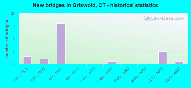
- New bridges - historical statistics
- 31930-1939
- 21940-1949
- 161950-1959
- 11980-1989
- 52010-2019
- 12020-2022

- Reconstructed bridges - Historical Statistics
- 51980-1989
- 21990-1999


- Bridge Condition - Deck
- 19.0%Very good
- 28.6%Good
- 38.1%Satisfactory
- 9.5%Fair
- 4.8%Serious

- Bridge Condition - Superstructure
- 21.7%Very good
- 21.7%Good
- 17.4%Satisfactory
- 30.4%Fair
- 4.3%Poor
- 4.3%Serious

- Bridge Condition - Substructure
- 26.1%Very good
- 17.4%Good
- 47.8%Satisfactory
- 4.3%Fair
- 4.3%Serious

- Bridge Condition - Channel
- 42.9%Very good
- 21.4%Good
- 35.7%Satisfactory
Find on map >> Show street view
Structure Number: 29, Location: BETWEEN EXITS 7&8 (Lat: 41.049850, Lng: -73.535778), Route carried "on" structure: Interstate 95, Year Built: 1958, Year Reconstructed: 2004, Status: Open, Structure Length: 2.35m (7.71ft), Average Daily Traffic: 103,200 (year 2017), Truck Traffic: 9%, Average Future Daily Traffic: 153,345 (year 2037), Design Load: HS 20, Features Intersected: CANAL STREET
Minimum Vertical Clearance: 30+ m (98+ ft), Kilometerpoint: 12.698, Lanes on structure: 6, Lanes under structure: 5, Base Highway Network: Yes, Owner: State Highway Agency, Approaching Roadway Width: 33.5m (109.9ft), Skew: 31 degrees, Material/Design: Steel, Design/Construction: Stringer/Multi-beam, Number Of Spans In Main Unit: 1, Length of Maximum Span: 21.9m (71.9ft), Curb-To-Curb Width: 33.6m (110.2ft), Out-to-Out Width: 35.8m (117.5ft)
Condition: Deck: Good, Superstructure: Good, Substructure: Satisfactory, Operating Rating: 56.4 metric tons, Method Used To Determine Operating Rating: Load and Resistance Factor Rating (LRFR) rating reported by rating factor(RF) method using HL-93 loadings, Inventory Rating: 43.4 metric tons, Method Used To Determine Inventory Rating: Load and Resistance Factor Rating (LRFR) rating reported by rating factor(RF) method using HL-93 loadings, Structural Evaluation: Equal to present minimum criteria, Deck Geometry: Superior to present desirable criteria, Underclear: Meets minimum limits, Approach Roadway Alignment: Equal to present desirable criteria, Designated Inspection Frequency: Every 24 months, Inspection Date: April 2021, Deck Structure Type: Concrete Cast-file-Place, Wearing Surface/Protective System: Wearing Surface: Bituminous, Membrane: Built-up, Deck Protection: Epoxy Coated Reinforcing
Find on map >> Show street view
Structure Number: 287, Location: I-395 EXIT NO. 85 (Lat: 41.590864, Lng: -71.976053), Route carried "on" structure: State highway 164, Year Built: 1958, Status: Open, Structure Length: 4.83m (15.85ft), Average Daily Traffic: 7,700 (year 2017), Truck Traffic: 5%, Average Future Daily Traffic: 11,441 (year 2037), Design Load: HS 20, Features Intersected: INTERSTATE 395
Minimum Vertical Clearance: 30+ m (98+ ft), Kilometerpoint: 12.118, Lanes on structure: 3, Lanes under structure: 5, Owner: State Highway Agency, Approaching Roadway Width: 12.2m (40.0ft), Skew: 1 degrees, Material/Design: Steel, Design/Construction: Stringer/Multi-beam, Number Of Spans In Main Unit: 2, Length of Maximum Span: 24.7m (81.0ft), Curb or Sidewalk Widths: Left: 1.5m (4.9ft), Right: 1.5m (4.9ft), Curb-To-Curb Width: 12.2m (40.0ft), Out-to-Out Width: 16.0m (52.5ft)
Condition: Deck: Fair, Superstructure: Fair, Substructure: Good, Operating Rating: 59.0 metric tons, Method Used To Determine Operating Rating: Load and Resistance Factor Rating (LRFR) rating reported by rating factor(RF) method using HL-93 loadings, Inventory Rating: 45.4 metric tons, Method Used To Determine Inventory Rating: Load and Resistance Factor Rating (LRFR) rating reported by rating factor(RF) method using HL-93 loadings, Structural Evaluation: Somewhat better than minimum adequacy, Deck Geometry: Meets minimum limits, Underclear: High priority of corrective action, Approach Roadway Alignment: Equal to present desirable criteria, Designated Inspection Frequency: Every 24 months, Inspection Date: Febuary 2021, Deck Structure Type: Concrete Cast-file-Place, Wearing Surface/Protective System: Wearing Surface: Bituminous, Membrane: Preformed Fabric
Find on map >> Show street view
Structure Number: 288, Location: 0.3 MI EAST OF ROUTE 164 (Lat: 41.593189, Lng: -71.970714), Route carried "on" structure: State highway 138, Year Built: 1958, Status: Open, Structure Length: 6.06m (19.88ft), Average Daily Traffic: 7,200 (year 2017), Truck Traffic: 5%, Average Future Daily Traffic: 10,698 (year 2037), Design Load: HS 20, Features Intersected: INTERSTATE-395
Minimum Vertical Clearance: 30+ m (98+ ft), Kilometerpoint: 11.619, Lanes on structure: 2, Lanes under structure: 4, Owner: State Highway Agency, Approaching Roadway Width: 12.2m (40.0ft), Skew: 3 degrees, Material/Design: Steel, Design/Construction: Stringer/Multi-beam, Number Of Spans In Main Unit: 4, Length of Maximum Span: 19.8m (65.0ft), Curb or Sidewalk Widths: Left: 0.5m (1.6ft), Right: 1.5m (4.9ft), Curb-To-Curb Width: 12.2m (40.0ft), Out-to-Out Width: 15.0m (49.2ft)
Condition: Deck: Satisfactory, Superstructure: Fair, Substructure: Satisfactory, Operating Rating: 63.5 metric tons, Method Used To Determine Operating Rating: Load and Resistance Factor Rating (LRFR) rating reported by rating factor(RF) method using HL-93 loadings, Inventory Rating: 48.9 metric tons, Method Used To Determine Inventory Rating: Load and Resistance Factor Rating (LRFR) rating reported by rating factor(RF) method using HL-93 loadings, Structural Evaluation: Somewhat better than minimum adequacy, Deck Geometry: Somewhat better than minimum adequacy, Underclear: High priority of corrective action, Approach Roadway Alignment: Equal to present desirable criteria, Designated Inspection Frequency: Every 24 months, Inspection Date: March 2021, Deck Structure Type: Concrete Cast-file-Place, Wearing Surface/Protective System: Wearing Surface: Bituminous, Membrane: Preformed Fabric
Find on map >> Show street view
Structure Number: 289, Location: .2 MI NORTH OF ROUTE 138 (Lat: 41.597011, Lng: -71.964603), Route carried "on" structure: City street , Year Built: 1958, Status: Open, Structure Length: 6.34m (20.80ft), Average Daily Traffic: 620 (year 2020), Truck Traffic: 7%, Average Future Daily Traffic: 921 (year 2040), Design Load: HS 20, Features Intersected: INTERSTATE-395, Facility Carried by Structure: TAYLOR HILL ROAD
Minimum Vertical Clearance: 30+ m (98+ ft), Kilometerpoint: 1.110, Lanes on structure: 2, Lanes under structure: 4, Owner: State Highway Agency, Approaching Roadway Width: 12.2m (40.0ft), Skew: 3 degrees, Material/Design: Steel, Design/Construction: Stringer/Multi-beam, Number Of Spans In Main Unit: 4, Length of Maximum Span: 19.9m (65.3ft), Curb or Sidewalk Widths: Left: 0.5m (1.6ft), Right: 0.5m (1.6ft), Curb-To-Curb Width: 12.2m (40.0ft), Out-to-Out Width: 13.9m (45.6ft)
Condition: Deck: Satisfactory, Superstructure: Fair, Substructure: Satisfactory, Operating Rating: 57.3 metric tons, Method Used To Determine Operating Rating: Load and Resistance Factor Rating (LRFR) rating reported by rating factor(RF) method using HL-93 loadings, Inventory Rating: 44.1 metric tons, Method Used To Determine Inventory Rating: Load and Resistance Factor Rating (LRFR) rating reported by rating factor(RF) method using HL-93 loadings, Structural Evaluation: Somewhat better than minimum adequacy, Deck Geometry: Equal to present desirable criteria, Underclear: High priority of corrective action, Approach Roadway Alignment: Better than present minimum criteria, Designated Inspection Frequency: Every 24 months, Inspection Date: August 2020, Deck Structure Type: Concrete Cast-file-Place, Wearing Surface/Protective System: Wearing Surface: Bituminous, Membrane: Preformed Fabric
Find on map >> Show street view
Structure Number: 29, Location: 1 MILE NORTH OF ROUTE 164 (Lat: 41.602478, Lng: -71.955739), Route carried "on" structure: City street , Year Built: 1958, Status: Open, Structure Length: 5.33m (17.49ft), Average Daily Traffic: 1,170 (year 2020), Truck Traffic: 7%, Average Future Daily Traffic: 1,739 (year 2040), Design Load: HS 20, Features Intersected: INTERSTATE-395, Facility Carried by Structure: NORMAN ROAD
Minimum Vertical Clearance: 30+ m (98+ ft), Kilometerpoint: 37.449, Lanes on structure: 2, Lanes under structure: 4, Owner: State Highway Agency, Approaching Roadway Width: 12.2m (40.0ft), Skew: 2 degrees, Material/Design: Steel, Design/Construction: Stringer/Multi-beam, Number Of Spans In Main Unit: 2, Length of Maximum Span: 28.3m (92.8ft), Curb or Sidewalk Widths: Left: 0.5m (1.6ft), Right: 0.5m (1.6ft), Curb-To-Curb Width: 12.2m (40.0ft), Out-to-Out Width: 13.9m (45.6ft)
Condition: Deck: Satisfactory, Superstructure: Fair, Substructure: Satisfactory, Operating Rating: 56.7 metric tons, Method Used To Determine Operating Rating: Load and Resistance Factor Rating (LRFR) rating reported by rating factor(RF) method using HL-93 loadings, Inventory Rating: 43.7 metric tons, Method Used To Determine Inventory Rating: Load and Resistance Factor Rating (LRFR) rating reported by rating factor(RF) method using HL-93 loadings, Structural Evaluation: Somewhat better than minimum adequacy, Deck Geometry: Better than present minimum criteria, Underclear: High priority of corrective action, Approach Roadway Alignment: Equal to present minimum criteria, Designated Inspection Frequency: Every 24 months, Inspection Date: August 2020, Deck Structure Type: Concrete Cast-file-Place, Wearing Surface/Protective System: Wearing Surface: Bituminous, Membrane: Built-up
Find on map >> Show street view
Structure Number: 291, Location: .3 MI SOUTH OF ROUTE 201 (Lat: 41.608219, Lng: -71.948067), Route carried "on" structure: Interstate 395, Year Built: 1958, Year Reconstructed: 1992, Status: Open, Structure Length: 6.92m (22.70ft), Average Daily Traffic: 32,100 (year 2017), Truck Traffic: 14%, Average Future Daily Traffic: 47,697 (year 2037), Design Load: H 20, Features Intersected: PACHAUG RIVER
Minimum Vertical Clearance: 30+ m (98+ ft), Kilometerpoint: 38.351, Lanes on structure: 4, Base Highway Network: Yes, Owner: State Highway Agency, Approaching Roadway Width: 22.9m (75.1ft), Skew: 23 degrees, Material/Design: Steel, Design/Construction: Stringer/Multi-beam, Number Of Spans In Main Unit: 3, Length of Maximum Span: 25.7m (84.3ft), Curb-To-Curb Width: 23.1m (75.8ft), Out-to-Out Width: 31.6m (103.7ft)
Condition: Deck: Satisfactory, Superstructure: Satisfactory, Substructure: Good, Channel: Good, Inventory Rating: 61.9 metric tons, Method Used To Determine Inventory Rating: Load Factor (LF), Structural Evaluation: Equal to present minimum criteria, Deck Geometry: Superior to present desirable criteria, Waterway Adequacy: Equal to present desirable criteria, Approach Roadway Alignment: Equal to present desirable criteria, Designated Inspection Frequency: Every 24 months, Inspection Date: May 2021, Deck Structure Type: Concrete Cast-file-Place, Wearing Surface/Protective System: Wearing Surface: Bituminous, Membrane: Preformed Fabric, Deck Protection: Epoxy Coated Reinforcing
Find on map >> Show street view
Structure Number: 292, Location: 1.8 MI NORTH OF ROUTE 138 (Lat: 41.614117, Lng: -71.945931), Route carried "on" structure: Interstate 395, Year Built: 1958, Year Reconstructed: 1996, Status: Open, Structure Length: 3.94m (12.93ft), Average Daily Traffic: 29,800 (year 2017), Truck Traffic: 16%, Average Future Daily Traffic: 44,280 (year 2037), Design Load: HS 20, Features Intersected: ROUTE 201
Minimum Vertical Clearance: 30+ m (98+ ft), Kilometerpoint: 39.043, Lanes on structure: 4, Lanes under structure: 2, Base Highway Network: Yes, Owner: State Highway Agency, Approaching Roadway Width: 23.2m (76.1ft), Skew: 30 degrees, Material/Design: Steel, Design/Construction: Stringer/Multi-beam, Number Of Spans In Main Unit: 3, Length of Maximum Span: 20.2m (66.3ft), Curb-To-Curb Width: 29.9m (98.1ft), Out-to-Out Width: 31.6m (103.7ft)
Condition: Deck: Good, Superstructure: Satisfactory, Substructure: Satisfactory, Operating Rating: 59.9 metric tons, Method Used To Determine Operating Rating: Load and Resistance Factor Rating (LRFR) rating reported by rating factor(RF) method using HL-93 loadings, Inventory Rating: 44.4 metric tons, Method Used To Determine Inventory Rating: Load and Resistance Factor Rating (LRFR) rating reported by rating factor(RF) method using HL-93 loadings, Structural Evaluation: Equal to present minimum criteria, Deck Geometry: Superior to present desirable criteria, Underclear: Meets minimum limits, Approach Roadway Alignment: Equal to present desirable criteria, Designated Inspection Frequency: Every 24 months, Inspection Date: December 2020, Deck Structure Type: Concrete Cast-file-Place, Wearing Surface/Protective System: Wearing Surface: Bituminous, Membrane: Preformed Fabric, Deck Protection: Epoxy Coated Reinforcing
Find on map >> Show street view
Structure Number: 293, Location: 0.5 MI NORTH OF ROUTE 201 (Lat: 41.621417, Lng: -71.944192), Route carried "on" structure: Interstate 395, Year Built: 1958, Year Reconstructed: 1992, Status: Open, Structure Length: 4.18m (13.71ft), Average Daily Traffic: 31,500 (year 2017), Truck Traffic: 9%, Average Future Daily Traffic: 46,806 (year 2037), Design Load: H 20, Features Intersected: BISHOP CROSSING RD
Minimum Vertical Clearance: 30+ m (98+ ft), Kilometerpoint: 39.863, Lanes on structure: 4, Lanes under structure: 2, Base Highway Network: Yes, Owner: State Highway Agency, Approaching Roadway Width: 22.9m (75.1ft), Skew: 32 degrees, Material/Design: Steel, Design/Construction: Stringer/Multi-beam, Number Of Spans In Main Unit: 3, Length of Maximum Span: 15.9m (52.2ft), Curb-To-Curb Width: 23.1m (75.8ft), Out-to-Out Width: 31.6m (103.7ft)
Condition: Deck: Satisfactory, Superstructure: Poor, Substructure: Satisfactory, Operating Rating: 41.1 metric tons, Method Used To Determine Operating Rating: Load and Resistance Factor Rating (LRFR) rating reported by rating factor(RF) method using HL-93 loadings, Inventory Rating: 31.8 metric tons, Method Used To Determine Inventory Rating: Load and Resistance Factor Rating (LRFR) rating reported by rating factor(RF) method using HL-93 loadings, Structural Evaluation: Meets minimum limits, Deck Geometry: Superior to present desirable criteria, Underclear: Somewhat better than minimum adequacy, Approach Roadway Alignment: Equal to present desirable criteria, Designated Inspection Frequency: Every 24 months, Inspection Date: November 2020, Total Project Cost: $6,100,000, Deck Structure Type: Concrete Cast-file-Place, Wearing Surface/Protective System: Wearing Surface: Bituminous, Membrane: Preformed Fabric, Deck Protection: Epoxy Coated Reinforcing
Find on map >> Show street view
Structure Number: 294, Location: 1.5 MI NORTH OF ROUTE 201 (Lat: 41.634225, Lng: -71.937108), Route carried "on" structure: Interstate 395, Year Built: 1958, Year Reconstructed: 1986, Status: Open, Structure Length: 3.80m (12.47ft), Average Daily Traffic: 31,100 (year 2017), Truck Traffic: 16%, Average Future Daily Traffic: 46,211 (year 2037), Design Load: HS 20, Features Intersected: ROODE ROAD
Minimum Vertical Clearance: 30+ m (98+ ft), Kilometerpoint: 41.408, Lanes on structure: 4, Lanes under structure: 2, Base Highway Network: Yes, Owner: State Highway Agency, Approaching Roadway Width: 22.6m (74.1ft), Skew: 31 degrees, Material/Design: Steel, Design/Construction: Stringer/Multi-beam, Number Of Spans In Main Unit: 3, Length of Maximum Span: 16.4m (53.8ft), Curb-To-Curb Width: 22.6m (74.1ft), Out-to-Out Width: 31.0m (101.7ft)
Condition: Deck: Satisfactory, Superstructure: Fair, Substructure: Satisfactory, Operating Rating: 73.8 metric tons, Method Used To Determine Operating Rating: Load Factor (LF), Inventory Rating: 44.4 metric tons, Method Used To Determine Inventory Rating: Load Factor (LF), Structural Evaluation: Somewhat better than minimum adequacy, Deck Geometry: Superior to present desirable criteria, Underclear: Meets minimum limits, Approach Roadway Alignment: Equal to present desirable criteria, Designated Inspection Frequency: Every 24 months, Inspection Date: June 2020, Deck Structure Type: Concrete Cast-file-Place, Wearing Surface/Protective System: Wearing Surface: Bituminous, Membrane: Preformed Fabric, Deck Protection: Epoxy Coated Reinforcing
Find on map >> Show street view
Structure Number: 665, Location: .9 MILE NORTH OF I-395 (Lat: 41.603528, Lng: -71.985400), Route carried "on" structure: State highway 12, Year Built: 1930, Year Reconstructed: 1988, Status: Open, Structure Length: 20.59m (67.55ft), Average Daily Traffic: 9,000 (year 2017), Truck Traffic: 6%, Average Future Daily Traffic: 13,373 (year 2037), Design Load: HS 20, Features Intersected: PACHAUG RIVER - P & W RR
Minimum Vertical Clearance: 30+ m (98+ ft), Kilometerpoint: 33.249, Lanes on structure: 2, Owner: State Highway Agency, Approaching Roadway Width: 9.1m (29.9ft), Skew: 9 degrees, Material/Design: Steel continuous, Design/Construction: Stringer/Multi-beam, Number Of Spans In Main Unit: 11, Number Of Approach Spans: 6, Length of Maximum Span: 17.7m (58.1ft), Curb or Sidewalk Widths: Left: 1.8m (5.9ft), Right: 0.0m, Curb-To-Curb Width: 9.1m (29.9ft), Out-to-Out Width: 11.9m (39.0ft)
Condition: Deck: Satisfactory, Superstructure: Fair, Substructure: Satisfactory, Channel: Satisfactory, Operating Rating: 53.5 metric tons, Method Used To Determine Operating Rating: Load Factor (LF), Inventory Rating: 31.7 metric tons, Method Used To Determine Inventory Rating: Load Factor (LF), Structural Evaluation: Somewhat better than minimum adequacy, Deck Geometry: Meets minimum limits, Underclear: High priority of corrective action, Waterway Adequacy: Equal to present desirable criteria, Approach Roadway Alignment: Equal to present minimum criteria, Designated Inspection Frequency: Every 24 months, Inspection Date: December 2019, Deck Structure Type: Concrete Cast-file-Place, Wearing Surface/Protective System: Wearing Surface: Bituminous, Membrane: Preformed Fabric
Find on map >> Show street view
Structure Number: 1353, Location: .1 MI EAST OF ROUTE 12 (Lat: 41.603525, Lng: -71.982933), Route carried "on" structure: State highway 138, Year Built: 1946, Status: Open, Structure Length: 3.05m (10.01ft), Average Daily Traffic: 4,700 (year 2017), Truck Traffic: 3%, Average Future Daily Traffic: 6,984 (year 2037), Design Load: HS 20, Features Intersected: PACHAUG RIVER
Minimum Vertical Clearance: 30+ m (98+ ft), Kilometerpoint: 10.026, Lanes on structure: 2, Owner: State Highway Agency, Approaching Roadway Width: 10.1m (33.1ft), Material/Design: Concrete, Design/Construction: Arch - Deck, Number Of Spans In Main Unit: 1, Length of Maximum Span: 30.5m (100.1ft), Curb or Sidewalk Widths: Left: 1.5m (4.9ft), Right: 1.5m (4.9ft), Curb-To-Curb Width: 10.1m (33.1ft), Out-to-Out Width: 14.3m (46.9ft)
Condition: Superstructure: Good, Substructure: Satisfactory, Channel: Good, Operating Rating: 89.8 metric tons, Method Used To Determine Operating Rating: Load Factor (LF), Inventory Rating: 89.8 metric tons, Method Used To Determine Inventory Rating: Load Factor (LF), Structural Evaluation: Equal to present minimum criteria, Deck Geometry: Meets minimum limits, Waterway Adequacy: Equal to present minimum criteria, Approach Roadway Alignment: Equal to present minimum criteria, Designated Inspection Frequency: Every 48 months, Inspection Date: October 2019, Wearing Surface/Protective System: Wearing Surface: Bituminous, Membrane: Other
Find on map >> Show street view
Structure Number: 1354, Location: 1 MI EAST OF ROUTE 12 (Lat: 41.603172, Lng: -71.982622), Route carried "on" structure: State highway 138, Year Built: 1946, Status: Open, Structure Length: 1.13m (3.71ft), Average Daily Traffic: 4,700 (year 2017), Truck Traffic: 3%, Average Future Daily Traffic: 6,984 (year 2037), Design Load: H 20, Features Intersected: ABANDONED CANAL
Minimum Vertical Clearance: 30+ m (98+ ft), Kilometerpoint: 10.091, Lanes on structure: 4, Owner: State Highway Agency, Approaching Roadway Width: 10.1m (33.1ft), Skew: 6 degrees, Material/Design: Concrete, Design/Construction: Slab, Number Of Spans In Main Unit: 1, Length of Maximum Span: 10.1m (33.1ft), Curb or Sidewalk Widths: Left: 1.5m (4.9ft), Right: 1.7m (5.6ft), Curb-To-Curb Width: 14.7m (48.2ft), Out-to-Out Width: 22.9m (75.1ft)
Condition: Superstructure: Satisfactory, Substructure: Good, Operating Rating: 21.4 metric tons, Method Used To Determine Operating Rating: Load and Resistance Factor Rating (LRFR) rating reported by rating factor(RF) method using HL-93 loadings, Inventory Rating: 16.5 metric tons, Method Used To Determine Inventory Rating: Load and Resistance Factor Rating (LRFR) rating reported by rating factor(RF) method using HL-93 loadings, Structural Evaluation: Meets minimum limits, Deck Geometry: High priority of replacement, Waterway Adequacy: Equal to present desirable criteria, Approach Roadway Alignment: Equal to present desirable criteria, Bridge Posting: Required (Relationship of Operating Rating to Maximum Legal Load: 20.0 - 29.9% below), Designated Inspection Frequency: Every 24 months, Inspection Date: May 2021
Find on map >> Show street view
Structure Number: 1355, Location: 2.4 MI EAST OF ROUTE 164 (Lat: 41.584978, Lng: -71.934411), Route carried "on" structure: State highway 138, Year Built: 1953, Status: Open, Structure Length: 1.40m (4.59ft), Average Daily Traffic: 9,500 (year 2017), Truck Traffic: 3%, Average Future Daily Traffic: 14,116 (year 2037), Design Load: HS 20, Features Intersected: PACHAUG RIVER
Minimum Vertical Clearance: 30+ m (98+ ft), Kilometerpoint: 14.999, Lanes on structure: 2, Owner: State Highway Agency, Approaching Roadway Width: 12.2m (40.0ft), Material/Design: Concrete, Design/Construction: Tee Beam, Number Of Spans In Main Unit: 1, Length of Maximum Span: 12.2m (40.0ft), Curb or Sidewalk Widths: Left: 0.5m (1.6ft), Right: 0.5m (1.6ft), Curb-To-Curb Width: 11.6m (38.1ft), Out-to-Out Width: 13.3m (43.6ft)
Condition: Deck: Good, Superstructure: Good, Substructure: Good, Channel: Satisfactory, Operating Rating: 61.7 metric tons, Method Used To Determine Operating Rating: Load Factor (LF), Inventory Rating: 37.2 metric tons, Method Used To Determine Inventory Rating: Load Factor (LF), Structural Evaluation: Better than present minimum criteria, Deck Geometry: Somewhat better than minimum adequacy, Waterway Adequacy: Better than present minimum criteria, Approach Roadway Alignment: Equal to present desirable criteria, Designated Inspection Frequency: Every 24 months, Inspection Date: July 2021, Deck Structure Type: Concrete Cast-file-Place, Wearing Surface/Protective System: Wearing Surface: Bituminous, Membrane: Preformed Fabric
Find on map >> Show street view
Structure Number: 1411, Location: .5 MI WEST OF ROUTE 201 (Lat: 41.549219, Lng: -71.895314), Route carried "on" structure: State highway 165, Year Built: 2014, Status: Open, Structure Length: 1.40m (4.59ft), Average Daily Traffic: 2,000 (year 2017), Truck Traffic: 5%, Average Future Daily Traffic: 2,972 (year 2037), Design Load: HL 93, Features Intersected: PACHAUG POND
Minimum Vertical Clearance: 30+ m (98+ ft), Kilometerpoint: 15.434, Lanes on structure: 2, Base Highway Network: Yes, Owner: State Highway Agency, Approaching Roadway Width: 10.4m (34.1ft), Material/Design: Steel, Design/Construction: Stringer/Multi-beam, Number Of Spans In Main Unit: 1, Length of Maximum Span: 13.1m (43.0ft), Curb-To-Curb Width: 10.4m (34.1ft), Out-to-Out Width: 11.5m (37.7ft)
Condition: Deck: Very good, Superstructure: Very good, Substructure: Very good, Channel: Very good, Operating Rating: 67.1 metric tons, Method Used To Determine Operating Rating: Load and Resistance Factor Rating (LRFR) rating reported by rating factor(RF) method using HL-93 loadings, Inventory Rating: 51.5 metric tons, Method Used To Determine Inventory Rating: Load and Resistance Factor Rating (LRFR) rating reported by rating factor(RF) method using HL-93 loadings, Structural Evaluation: Equal to present desirable criteria, Deck Geometry: Equal to present minimum criteria, Waterway Adequacy: Superior to present desirable criteria, Approach Roadway Alignment: Equal to present desirable criteria, Designated Inspection Frequency: Every 24 months, Inspection Date: April 2020, Deck Structure Type: Concrete Cast-file-Place, Wearing Surface/Protective System: Wearing Surface: Bituminous, Membrane: Built-up, Deck Protection: Epoxy Coated Reinforcing
Find on map >> Show street view
Structure Number: 1412, Location: 0.6 MI EAST OF ROUTE 201 (Lat: 41.557392, Lng: -71.876425), Route carried "on" structure: State highway 165, Year Built: 1934, Year Reconstructed: 1986, Status: Open, Structure Length: 0.67m (2.20ft), Average Daily Traffic: 2,300 (year 2017), Truck Traffic: 6%, Average Future Daily Traffic: 3,418 (year 2037), Design Load: H 20, Features Intersected: GLASGO POND
Minimum Vertical Clearance: 30+ m (98+ ft), Kilometerpoint: 17.252, Lanes on structure: 2, Base Highway Network: Yes, Owner: State Highway Agency, Approaching Roadway Width: 9.8m (32.2ft), Material/Design: Concrete, Design/Construction: Slab, Number Of Spans In Main Unit: 1, Length of Maximum Span: 6.1m (20.0ft), Curb-To-Curb Width: 9.6m (31.5ft), Out-to-Out Width: 10.7m (35.1ft)
Condition: Deck: Fair, Superstructure: Fair, Substructure: Fair, Channel: Satisfactory, Operating Rating: 58.6 metric tons, Method Used To Determine Operating Rating: Load Factor (LF), Inventory Rating: 35.2 metric tons, Method Used To Determine Inventory Rating: Load Factor (LF), Structural Evaluation: Somewhat better than minimum adequacy, Deck Geometry: Meets minimum limits, Waterway Adequacy: Equal to present minimum criteria, Approach Roadway Alignment: Equal to present desirable criteria, Designated Inspection Frequency: Every 24 months, Underwater Inspection Frequency: Every 24 months, Inspection Date: April 2020, Underwater Inspection Date: April 2020, Deck Structure Type: Concrete Cast-file-Place, Wearing Surface/Protective System: Wearing Surface: Bituminous, Membrane: Preformed Fabric
Find on map >> Show street view
Structure Number: 4668, Location: 0.8 MI NORTH OF ROUTE 138 (Lat: 41.594350, Lng: -71.925922), Route carried "on" structure: City street , Year Built: 2014, Status: Open, Structure Length: 2.35m (7.71ft), Average Daily Traffic: 340 (year 2020), Truck Traffic: 5%, Average Future Daily Traffic: 505 (year 2040), Design Load: HL 93, Features Intersected: HOPEVILLE POND, Facility Carried by Structure: BITGOOD ROAD
Minimum Vertical Clearance: 30+ m (98+ ft), Kilometerpoint: 1.287, Lanes on structure: 2, Owner: Town or Township Highway Agency, Approaching Roadway Width: 7.6m (24.9ft), Material/Design: Steel, Design/Construction: Stringer/Multi-beam, Number Of Spans In Main Unit: 1, Length of Maximum Span: 22.9m (75.1ft), Curb-To-Curb Width: 7.6m (24.9ft), Out-to-Out Width: 8.7m (28.5ft)
Condition: Deck: Good, Superstructure: Very good, Substructure: Very good, Channel: Very good, Operating Rating: 55.7 metric tons, Method Used To Determine Operating Rating: Load and Resistance Factor Rating (LRFR) rating reported by rating factor(RF) method using HL-93 loadings, Inventory Rating: 43.1 metric tons, Method Used To Determine Inventory Rating: Load and Resistance Factor Rating (LRFR) rating reported by rating factor(RF) method using HL-93 loadings, Structural Evaluation: Equal to present desirable criteria, Deck Geometry: Somewhat better than minimum adequacy, Waterway Adequacy: Superior to present desirable criteria, Approach Roadway Alignment: Equal to present desirable criteria, Designated Inspection Frequency: Every 24 months, Inspection Date: March 2020, Deck Structure Type: Concrete Cast-file-Place, Wearing Surface/Protective System: Wearing Surface: Bituminous, Membrane: Built-up, Deck Protection: Epoxy Coated Reinforcing
Find on map >> Show street view
Structure Number: 4669, Location: 1850 FT N OF ROUTE 138 (Lat: 41.589692, Lng: -71.932000), Route carried "on" structure: City street , Year Built: 2011, Status: Open, Structure Length: 1.89m (6.20ft), Average Daily Traffic: 357 (year 2020), Truck Traffic: 2%, Average Future Daily Traffic: 530 (year 2040), Design Load: HL 93, Features Intersected: PACHAUG RIVER, Facility Carried by Structure: BITGOOD ROAD
Minimum Vertical Clearance: 30+ m (98+ ft), Kilometerpoint: 0.563, Lanes on structure: 2, Owner: Town or Township Highway Agency, Approaching Roadway Width: 7.6m (24.9ft), Material/Design: Prestressed concrete, Design/Construction: Box Beam or Girders - Multiple, Number Of Spans In Main Unit: 1, Length of Maximum Span: 18.3m (60.0ft), Curb-To-Curb Width: 7.6m (24.9ft), Out-to-Out Width: 8.7m (28.5ft)
Condition: Deck: Good, Superstructure: Good, Substructure: Very good, Channel: Good, Operating Rating: 46.3 metric tons, Method Used To Determine Operating Rating: Load and Resistance Factor Rating (LRFR) rating reported by rating factor(RF) method using HL-93 loadings, Inventory Rating: 35.6 metric tons, Method Used To Determine Inventory Rating: Load and Resistance Factor Rating (LRFR) rating reported by rating factor(RF) method using HL-93 loadings, Structural Evaluation: Better than present minimum criteria, Deck Geometry: Somewhat better than minimum adequacy, Waterway Adequacy: Equal to present desirable criteria, Approach Roadway Alignment: Equal to present desirable criteria, Designated Inspection Frequency: Every 24 months, Inspection Date: March 2020, Deck Structure Type: Other, Wearing Surface/Protective System: Wearing Surface: Bituminous, Membrane: Built-up
Find on map >> Show street view
Structure Number: 4671, Location: 100' EAST OF SHELDON ROAD (Lat: 41.570044, Lng: -71.875628), Route carried "on" structure: City street , Year Built: 1938, Status: Posted for load, Structure Length: 2.65m (8.69ft), Average Daily Traffic: 530 (year 2021), Truck Traffic: 7%, Average Future Daily Traffic: 788 (year 2041), Features Intersected: PACHAUG RIVER, Facility Carried by Structure: CARROLL ROAD
Minimum Vertical Clearance: 30+ m (98+ ft), Kilometerpoint: 0.048, Lanes on structure: 2, Owner: Town or Township Highway Agency, Approaching Roadway Width: 6.1m (20.0ft), Material/Design: Steel, Design/Construction: Slab, Number Of Spans In Main Unit: 3, Length of Maximum Span: 7.9m (25.9ft), Curb or Sidewalk Widths: Left: 0.2m (0.7ft), Right: 1.5m (4.9ft), Curb-To-Curb Width: 6.1m (20.0ft), Out-to-Out Width: 8.4m (27.6ft)
Condition: Deck: Serious, Superstructure: Serious, Substructure: Serious, Channel: Satisfactory, Operating Rating: 18.1 metric tons, Method Used To Determine Operating Rating: Field evaluation and documented engineering judgment, Inventory Rating: 13.6 metric tons, Method Used To Determine Inventory Rating: Field evaluation and documented engineering judgment, Structural Evaluation: High priority of corrective action, Deck Geometry: High priority of corrective action, Waterway Adequacy: Meets minimum limits, Approach Roadway Alignment: Better than present minimum criteria, Bridge Posting: Required (Relationship of Operating Rating to Maximum Legal Load: > 39.9% below), Designated Inspection Frequency: Every 12 months, Underwater Inspection Frequency: Every 12 months, Inspection Date: April 2021, Underwater Inspection Date: April 2021, Total Project Cost: $530,000 ( Estimate for 2014), Deck Structure Type: Concrete Cast-file-Place, Wearing Surface/Protective System: Wearing Surface: Bituminous
Find on map >> Show street view
Structure Number: 4673, Location: 1000' SOUTH OF ROUTE 201 (Lat: 41.609653, Lng: -71.938661), Route carried "on" structure: City street , Year Built: 2013, Status: Open, Structure Length: 3.11m (10.20ft), Average Daily Traffic: 529 (year 2020), Truck Traffic: 5%, Average Future Daily Traffic: 786 (year 2040), Design Load: HL 93, Features Intersected: PACHAUG RIVER, Facility Carried by Structure: EDMUND ROAD
Minimum Vertical Clearance: 30+ m (98+ ft), Kilometerpoint: 2.993, Lanes on structure: 2, Owner: Town or Township Highway Agency, Approaching Roadway Width: 7.6m (24.9ft), Material/Design: Steel, Design/Construction: Stringer/Multi-beam, Number Of Spans In Main Unit: 1, Length of Maximum Span: 30.5m (100.1ft), Curb-To-Curb Width: 7.5m (24.6ft), Out-to-Out Width: 8.7m (28.5ft)
Condition: Deck: Very good, Superstructure: Very good, Substructure: Very good, Channel: Very good, Operating Rating: 51.2 metric tons, Method Used To Determine Operating Rating: Load and Resistance Factor Rating (LRFR) rating reported by rating factor(RF) method using HL-93 loadings, Inventory Rating: 39.5 metric tons, Method Used To Determine Inventory Rating: Load and Resistance Factor Rating (LRFR) rating reported by rating factor(RF) method using HL-93 loadings, Structural Evaluation: Equal to present desirable criteria, Deck Geometry: Meets minimum limits, Waterway Adequacy: Equal to present desirable criteria, Approach Roadway Alignment: Equal to present desirable criteria, Designated Inspection Frequency: Every 24 months, Inspection Date: April 2020, Deck Structure Type: Concrete Cast-file-Place, Wearing Surface/Protective System: Wearing Surface: Bituminous, Membrane: Built-up, Deck Protection: Epoxy Coated Reinforcing
Find on map >> Show street view
Structure Number: 4674, Location: 0.2 MI EAST OF ROUTE 12 (Lat: 41.605806, Lng: -71.979211), Route carried "on" structure: City street , Year Built: 1951, Status: Open, Structure Length: 2.59m (8.50ft), Average Daily Traffic: 4,049 (year 2020), Truck Traffic: 5%, Average Future Daily Traffic: 6,016 (year 2040), Design Load: H 20, Features Intersected: PACHAUG RIVER, Facility Carried by Structure: ASHLAND STREET
Minimum Vertical Clearance: 30+ m (98+ ft), Kilometerpoint: 0.177, Lanes on structure: 2, Owner: Town or Township Highway Agency, Approaching Roadway Width: 9.1m (29.9ft), Skew: 1 degrees, Material/Design: Concrete, Design/Construction: Tee Beam, Number Of Spans In Main Unit: 2, Length of Maximum Span: 12.2m (40.0ft), Curb or Sidewalk Widths: Left: 1.5m (4.9ft), Right: 1.5m (4.9ft), Curb-To-Curb Width: 9.1m (29.9ft), Out-to-Out Width: 12.8m (42.0ft)
Condition: Deck: Satisfactory, Superstructure: Satisfactory, Substructure: Satisfactory, Channel: Satisfactory, Operating Rating: 97.2 metric tons, Method Used To Determine Operating Rating: Load and Resistance Factor Rating (LRFR) rating reported by rating factor(RF) method using HL-93 loadings, Inventory Rating: 97.2 metric tons, Method Used To Determine Inventory Rating: Load and Resistance Factor Rating (LRFR) rating reported by rating factor(RF) method using HL-93 loadings, Structural Evaluation: Equal to present minimum criteria, Deck Geometry: Meets minimum limits, Waterway Adequacy: Equal to present minimum criteria, Approach Roadway Alignment: Better than present minimum criteria, Designated Inspection Frequency: Every 24 months, Underwater Inspection Frequency: Every 24 months, Inspection Date: April 2020, Underwater Inspection Date: April 2020, Deck Structure Type: Concrete Cast-file-Place, Wearing Surface/Protective System: Wearing Surface: Monolithic Concrete
Find on map >> Show street view
Structure Number: 5568, Location: 0.2 MI SOUTH OF ROUTE 201 (Lat: 41.608911, Lng: -71.959114), Route carried "on" structure: City street , Year Built: 2019, Status: Open, Structure Length: 1.66m (5.45ft), Average Daily Traffic: 691 (year 2020), Truck Traffic: 7%, Average Future Daily Traffic: 1,027 (year 2040), Design Load: HL 93, Features Intersected: PACHAUG RIVER, Facility Carried by Structure: NORMAN ROAD
Minimum Vertical Clearance: 30+ m (98+ ft), Kilometerpoint: 2.543, Lanes on structure: 2, Owner: Town or Township Highway Agency, Approaching Roadway Width: 7.3m (24.0ft), Material/Design: Prestressed concrete, Design/Construction: Box Beam or Girders - Multiple, Number Of Spans In Main Unit: 1, Length of Maximum Span: 16.2m (53.1ft), Curb-To-Curb Width: 7.3m (24.0ft), Out-to-Out Width: 8.4m (27.6ft)
Condition: Deck: Good, Superstructure: Very good, Substructure: Very good, Channel: Very good, Operating Rating: 68.4 metric tons, Method Used To Determine Operating Rating: Load and Resistance Factor Rating (LRFR) rating reported by rating factor(RF) method using HL-93 loadings, Inventory Rating: 52.5 metric tons, Method Used To Determine Inventory Rating: Load and Resistance Factor Rating (LRFR) rating reported by rating factor(RF) method using HL-93 loadings, Structural Evaluation: Equal to present desirable criteria, Deck Geometry: Meets minimum limits, Waterway Adequacy: Equal to present desirable criteria, Approach Roadway Alignment: Equal to present desirable criteria, Designated Inspection Frequency: Every 24 months, Inspection Date: April 2019, Total Project Cost: $2,230,000 ( Estimate for 2016), Deck Structure Type: Concrete Cast-file-Place, Wearing Surface/Protective System: Wearing Surface: Bituminous, Membrane: Other, Deck Protection: Epoxy Coated Reinforcing
Find on map >> Show street view
Structure Number: 5717, Location: .3 MI NORTH OF ROUTE 165 (Lat: 41.556636, Lng: -71.889267), Route carried "on" structure: State highway 201, Year Built: 1989, Status: Open, Structure Length: 2.10m (6.89ft), Average Daily Traffic: 1,100 (year 2020), Truck Traffic: 2%, Average Future Daily Traffic: 1,634 (year 2040), Design Load: HS 20, Features Intersected: PACHAUG RIVER
Minimum Vertical Clearance: 30+ m (98+ ft), Kilometerpoint: 19.988, Lanes on structure: 2, Owner: State Highway Agency, Approaching Roadway Width: 8.8m (28.9ft), Material/Design: Prestressed concrete, Design/Construction: Box Beam or Girders - Multiple, Number Of Spans In Main Unit: 1, Length of Maximum Span: 19.8m (65.0ft), Curb or Sidewalk Widths: Left: 1.7m (5.6ft), Right: 0.0m, Curb-To-Curb Width: 9.1m (29.9ft), Out-to-Out Width: 11.7m (38.4ft)
Condition: Deck: Very good, Superstructure: Good, Substructure: Satisfactory, Channel: Very good, Operating Rating: 68.0 metric tons, Method Used To Determine Operating Rating: Load Factor (LF), Inventory Rating: 38.1 metric tons, Method Used To Determine Inventory Rating: Load Factor (LF), Structural Evaluation: Equal to present minimum criteria, Deck Geometry: Somewhat better than minimum adequacy, Waterway Adequacy: Equal to present desirable criteria, Approach Roadway Alignment: Better than present minimum criteria, Designated Inspection Frequency: Every 24 months, Inspection Date: November 2021, Deck Structure Type: Other, Wearing Surface/Protective System: Wearing Surface: Bituminous, Membrane: Preformed Fabric
Find on map >> Show street view
Structure Number: 5851, Location: 0.5 MI SOUTH OF ROUTE 138 (Lat: 41.566464, Lng: -71.878836), Route carried "on" structure: City street , Year Built: 2020, Status: Open, Structure Length: 1.25m (4.10ft), Average Daily Traffic: 551 (year 2020), Truck Traffic: 7%, Average Future Daily Traffic: 819 (year 2040), Design Load: HL 93, Features Intersected: DOANVILLE POND, Facility Carried by Structure: SHELDON ROAD
Minimum Vertical Clearance: 30+ m (98+ ft), Kilometerpoint: 0.982, Lanes on structure: 2, Owner: Town or Township Highway Agency, Approaching Roadway Width: 7.3m (24.0ft), Material/Design: Prestressed concrete, Design/Construction: Box Beam or Girders - Multiple, Number Of Spans In Main Unit: 1, Length of Maximum Span: 11.6m (38.1ft), Curb-To-Curb Width: 7.3m (24.0ft), Out-to-Out Width: 8.4m (27.6ft)
Condition: Deck: Very good, Superstructure: Very good, Substructure: Very good, Channel: Very good, Operating Rating: 73.2 metric tons, Method Used To Determine Operating Rating: Load and Resistance Factor Rating (LRFR) rating reported by rating factor(RF) method using HL-93 loadings, Inventory Rating: 56.4 metric tons, Method Used To Determine Inventory Rating: Load and Resistance Factor Rating (LRFR) rating reported by rating factor(RF) method using HL-93 loadings, Structural Evaluation: Equal to present desirable criteria, Deck Geometry: Meets minimum limits, Waterway Adequacy: Equal to present minimum criteria, Approach Roadway Alignment: Equal to present minimum criteria, Designated Inspection Frequency: Every 24 months, Inspection Date: July 2020, Total Project Cost: $2,231,000 ( Estimate for 2016), Deck Structure Type: Other, Wearing Surface/Protective System: Wearing Surface: Bituminous, Membrane: Other
Find on map >> Show street view
Structure Number: 287, Location: I-395 EXIT NO. 85 (Lat: 41.590864, Lng: -71.976053), Route carried "under" structure: Interstate 395, Year Built: 1958, Structure Length: 0. m, Average Daily Traffic: 25,700 (year 2017), Truck Traffic: 14%, Features Intersected: INTERSTATE 395, Facility Carried by Structure: ROUTE 164
Minimum Vertical Clearance: 4.52m (14.83ft), Kilometerpoint: 35.325, Lanes on structure: 3, Lanes under structure: 5, Material/Design: Steel, Design/Construction: Stringer/Multi-beam, Length of Maximum Span: 24.7m (81.0ft)
Find on map >> Show street view
Structure Number: 288, Location: 0.3 MI EAST OF ROUTE 164 (Lat: 41.593189, Lng: -71.970714), Route carried "under" structure: Interstate 395, Year Built: 1958, Structure Length: 0. m, Average Daily Traffic: 25,700 (year 2017), Truck Traffic: 9%, Features Intersected: INTERSTATE-395, Facility Carried by Structure: ROUTE 138
Minimum Vertical Clearance: 4.95m (16.24ft), Kilometerpoint: 35.856, Lanes on structure: 2, Lanes under structure: 4, Material/Design: Steel, Design/Construction: Stringer/Multi-beam, Length of Maximum Span: 19.8m (65.0ft)
Find on map >> Show street view
Structure Number: 289, Location: .2 MI NORTH OF ROUTE 138 (Lat: 41.597011, Lng: -71.964603), Route carried "under" structure: Interstate 395, Year Built: 1958, Structure Length: 0. m, Average Daily Traffic: 32,500 (year 2017), Truck Traffic: 9%, Features Intersected: INTERSTATE-395, Facility Carried by Structure: TAYLOR HILL ROAD
Minimum Vertical Clearance: 4.60m (15.09ft), Kilometerpoint: 36.516, Lanes on structure: 2, Lanes under structure: 4, Material/Design: Steel, Design/Construction: Stringer/Multi-beam, Length of Maximum Span: 19.9m (65.3ft)
Find on map >> Show street view
Structure Number: 29, Location: 1 MILE NORTH OF ROUTE 164 (Lat: 41.602478, Lng: -71.955739), Route carried "under" structure: Interstate 395, Year Built: 1958, Structure Length: 0. m, Average Daily Traffic: 32,500 (year 2017), Truck Traffic: 9%, Features Intersected: INTERSTATE-395, Facility Carried by Structure: NORMAN ROAD
Minimum Vertical Clearance: 7.37m (24.18ft), Kilometerpoint: 37.449, Lanes on structure: 2, Lanes under structure: 4, Material/Design: Steel, Design/Construction: Stringer/Multi-beam, Length of Maximum Span: 28.3m (92.8ft)
Find on map >> Show street view
Structure Number: 292, Location: 1.8 MI NORTH OF ROUTE 138 (Lat: 41.614117, Lng: -71.945931), Route carried "under" structure: State highway 201, Year Built: 1958, Structure Length: 0. m, Average Daily Traffic: 3,000 (year 2017), Truck Traffic: 3%, Features Intersected: ROUTE 201, Facility Carried by Structure: INTERSTATE-395
Minimum Vertical Clearance: 4.47m (14.67ft), Kilometerpoint: 29.194, Lanes on structure: 4, Lanes under structure: 2, Material/Design: Steel, Design/Construction: Stringer/Multi-beam, Length of Maximum Span: 20.2m (66.3ft)