Bridge Statistics for Greenfield, Massachusetts (MA)
Condition, Traffic, Stress, Structural Evaluation, Project Costs
- National Bridge Inventory (NBI) Statistics
- 19Number of bridges
- 276ft / 84.5mTotal length
- $79,090,000Total costs
- 229,540Total average daily traffic
- 20,080Total average daily truck traffic
- National Bridge Inventory (NBI) Registered Bridges for Greenfield
- No street view available for this location
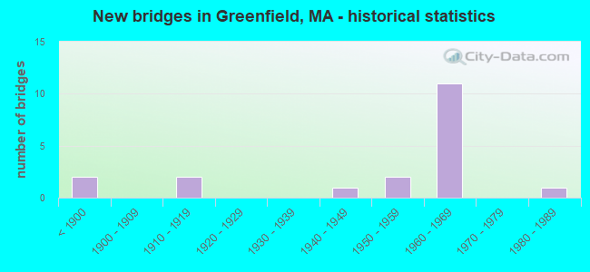
- New bridges - historical statistics
- 2Before 1900
- 21910-1919
- 11940-1949
- 21950-1959
- 111960-1969
- 11980-1989

- Reconstructed bridges - Historical Statistics
- 11920-1929
- 01930-1939
- 01940-1949
- 01950-1959
- 01960-1969
- 01970-1979
- 21980-1989
- 11990-1999
- 12000-2009


- Bridge Condition - Deck
- 7.7%Very good
- 30.8%Good
- 23.1%Satisfactory
- 7.7%Fair
- 15.4%Poor
- 15.4%Serious

- Bridge Condition - Superstructure
- 25.0%Good
- 25.0%Satisfactory
- 31.3%Fair
- 18.8%Poor

- Bridge Condition - Substructure
- 18.8%Good
- 43.8%Satisfactory
- 31.3%Fair
- 6.3%Poor

- Bridge Condition - Channel
- 42.9%Good
- 42.9%Satisfactory
- 14.3%Fair
Find on map >> Show street view
Structure Number: G120010LKMUNNBI, Location: JCT OF RIVERSIDE DR (Lat: 42.590947, Lng: -72.615428), Route carried "on" structure: City street , Year Built: 1910, Year Reconstructed: 1933, Status: Open, Structure Length: 1.81m (5.94ft), Average Daily Traffic: 5,200 (year 2003), Truck Traffic: 6%, Average Future Daily Traffic: 8,212 (year 2032), Features Intersected: WATER GREEN RIVER, Facility Carried by Structure: HWY COLRAIN ST
Minimum Vertical Clearance: 30+ m (98+ ft), Kilometerpoint: 0.772, Lanes on structure: 2, Owner: Town or Township Highway Agency, Approaching Roadway Width: 7.3m (24.0ft), Material/Design: Concrete, Design/Construction: Arch - Deck, Number Of Spans In Main Unit: 1, Length of Maximum Span: 18.1m (59.4ft), Curb or Sidewalk Widths: Left: 0.2m (0.7ft), Right: 1.2m (3.9ft), Curb-To-Curb Width: 7.3m (24.0ft), Out-to-Out Width: 9.3m (30.5ft)
Condition: Superstructure: Fair, Substructure: Satisfactory, Channel: Satisfactory, Operating Rating: 78.4 metric tons, Method Used To Determine Operating Rating: Load Factor (LF), Inventory Rating: 40.8 metric tons, Method Used To Determine Inventory Rating: Load Factor (LF), Structural Evaluation: Somewhat better than minimum adequacy, Deck Geometry: High priority of replacement, Waterway Adequacy: Somewhat better than minimum adequacy, Approach Roadway Alignment: Meets minimum limits, Length Of Structure Improvement: 1.90m (6.23ft), Designated Inspection Frequency: Every 24 months, Inspection Date: August 2021, Bridge Improvement Cost: $695,000, Roadway Improvement Cost: $70,000, Total Project Cost: $1,043,000 ( Estimate for 2022), Wearing Surface/Protective System: Wearing Surface: Bituminous
Find on map >> Show street view
Structure Number: G120070UGDOTNBI, Location: 100' E JCT RIVER ST. (Lat: 42.585769, Lng: -72.612044), Route carried "on" structure: Alternate State highway 2, Year Built: 1957, Status: Open, Structure Length: 4.20m (13.78ft), Average Daily Traffic: 12,396 (year 2015), Truck Traffic: 10%, Average Future Daily Traffic: 21,647 (year 2031), Design Load: H 20, Features Intersected: WATER GREEN RIVER
Minimum Vertical Clearance: 30+ m (98+ ft), Kilometerpoint: 0.697, Lanes on structure: 2, Base Highway Network: Yes, Owner: State Highway Agency, Approaching Roadway Width: 14.6m (47.9ft), Material/Design: Steel, Design/Construction: Stringer/Multi-beam, Number Of Spans In Main Unit: 1, Length of Maximum Span: 40.5m (132.9ft), Curb or Sidewalk Widths: Left: 1.5m (4.9ft), Right: 1.5m (4.9ft), Curb-To-Curb Width: 14.6m (47.9ft), Out-to-Out Width: 18.7m (61.4ft)
Condition: Deck: Serious, Superstructure: Fair, Substructure: Fair, Channel: Good, Operating Rating: 60.0 metric tons, Method Used To Determine Operating Rating: Allowable Stress (AS), Inventory Rating: 31.0 metric tons, Method Used To Determine Inventory Rating: Allowable Stress (AS), Structural Evaluation: Somewhat better than minimum adequacy, Deck Geometry: Superior to present desirable criteria, Waterway Adequacy: Equal to present desirable criteria, Approach Roadway Alignment: Equal to present desirable criteria, Length Of Structure Improvement: 4.30m (14.11ft), Designated Inspection Frequency: Every 6 months, Other Special Inspection Frequency: Every 6 months, Inspection Date: May 2020, Other Special Inspection Date: November 2021, Bridge Improvement Cost: $3,159,000, Roadway Improvement Cost: $316,000, Total Project Cost: $4,739,000 ( Estimate for 2022), Deck Structure Type: Concrete Cast-file-Place, Wearing Surface/Protective System: Wearing Surface: Latex Concrete
Find on map >> Show street view
Structure Number: G120130Q9MUNNBI, Location: AT JCT OF DFLD ST (Lat: 42.580400, Lng: -72.599419), Route carried "on" structure: City street , Year Built: 1917, Status: Open, Structure Length: 2.74m (8.99ft), Average Daily Traffic: 1,121 (year 2013), Truck Traffic: 6%, Average Future Daily Traffic: 4,084 (year 2032), Features Intersected: WATER GREEN RIVER, Facility Carried by Structure: HWY MERIDIAN ST
Minimum Vertical Clearance: 30+ m (98+ ft), Kilometerpoint: 0.885, Lanes on structure: 2, Owner: Town or Township Highway Agency, Approaching Roadway Width: 9.1m (29.9ft), Material/Design: Concrete, Design/Construction: Arch - Deck, Number Of Spans In Main Unit: 1, Length of Maximum Span: 27.4m (89.9ft), Curb or Sidewalk Widths: Left: 0.0m, Right: 1.7m (5.6ft), Curb-To-Curb Width: 7.3m (24.0ft), Out-to-Out Width: 11.2m (36.7ft)
Condition: Superstructure: Fair, Substructure: Fair, Channel: Fair, Operating Rating: 38.5 metric tons, Method Used To Determine Operating Rating: Load Factor (LF), Inventory Rating: 31.0 metric tons, Method Used To Determine Inventory Rating: Load Factor (LF), Structural Evaluation: Somewhat better than minimum adequacy, Deck Geometry: Meets minimum limits, Waterway Adequacy: Equal to present minimum criteria, Approach Roadway Alignment: Somewhat better than minimum adequacy, Length Of Structure Improvement: 2.80m (9.19ft), Designated Inspection Frequency: Every 24 months, Inspection Date: November 2021, Bridge Improvement Cost: $1,232,000, Roadway Improvement Cost: $124,000, Total Project Cost: $1,849,000 ( Estimate for 2022)
Find on map >> Show street view
Structure Number: G120140LMMUNNBI, Location: 0.5 MI E INT ST 2A (Lat: 42.583536, Lng: -72.605031), Route carried "on" structure: City street , Year Built: 1981, Status: Open, Structure Length: 3.77m (12.37ft), Average Daily Traffic: 14,483 (year 2017), Truck Traffic: 6%, Average Future Daily Traffic: 9,190 (year 2032), Design Load: H 20, Features Intersected: WATER GREEN RIVER, Facility Carried by Structure: HWY MILL ST
Minimum Vertical Clearance: 30+ m (98+ ft), Kilometerpoint: 0.885, Lanes on structure: 2, Owner: Town or Township Highway Agency, Approaching Roadway Width: 12.2m (40.0ft), Material/Design: Steel, Design/Construction: Stringer/Multi-beam, Number Of Spans In Main Unit: 1, Length of Maximum Span: 36.6m (120.1ft), Curb or Sidewalk Widths: Left: 1.5m (4.9ft), Right: 0.2m (0.7ft), Curb-To-Curb Width: 12.2m (40.0ft), Out-to-Out Width: 14.8m (48.6ft)
Condition: Deck: Good, Superstructure: Good, Substructure: Satisfactory, Channel: Good, Operating Rating: 69.0 metric tons, Method Used To Determine Operating Rating: Load Factor (LF), Inventory Rating: 41.4 metric tons, Method Used To Determine Inventory Rating: Load Factor (LF), Structural Evaluation: Equal to present minimum criteria, Deck Geometry: Somewhat better than minimum adequacy, Waterway Adequacy: Superior to present desirable criteria, Approach Roadway Alignment: Better than present minimum criteria, Length Of Structure Improvement: 3.80m (12.47ft), Designated Inspection Frequency: Every 24 months, Inspection Date: May 2021, Bridge Improvement Cost: $430,000, Roadway Improvement Cost: $44,000, Total Project Cost: $646,000 ( Estimate for 2022), Deck Structure Type: Concrete Cast-file-Place, Wearing Surface/Protective System: Wearing Surface: Bituminous, Membrane: Built-up
Find on map >> Show street view
Structure Number: G12020134DOTNBI, Location: AT GRNFIELD-MONTAGUE T.L. (Lat: 42.580617, Lng: -72.579486), Route carried "on" structure: City street , Year Built: 1947, Status: Closed, Structure Length: 23.51m (77.13ft), Average Daily Traffic: 14,100 (year 2019), Truck Traffic: 8%, Average Future Daily Traffic: 30,638 (year 2032), Design Load: H 20, Features Intersected: WATER CONNECTICUT RIVER, Facility Carried by Structure: HWY MTGUE CTY RD
Minimum Vertical Clearance: 4.49m (14.73ft), Kilometerpoint: 0.000, Lanes on structure: 2, Owner: State Highway Agency, Approaching Roadway Width: 7.9m (25.9ft), Skew: 2 degrees, Material/Design: Steel, Design/Construction: Truss - Thru, Number Of Spans In Main Unit: 2, Number Of Approach Spans: 2, Length of Maximum Span: 121.3m (398.0ft), Curb or Sidewalk Widths: Left: 0.2m (0.7ft), Right: 1.6m (5.2ft), Curb-To-Curb Width: 7.9m (25.9ft), Out-to-Out Width: 11.3m (37.1ft)
Condition: Deck: Serious, Superstructure: Poor, Substructure: Poor, Channel: Satisfactory, Operating Rating: 38.5 metric tons, Method Used To Determine Operating Rating: Load Factor (LF), Inventory Rating: 23.1 metric tons, Method Used To Determine Inventory Rating: Load Factor (LF), Structural Evaluation: Meets minimum limits, Deck Geometry: High priority of corrective action, Waterway Adequacy: Equal to present desirable criteria, Approach Roadway Alignment: Better than present minimum criteria, Length Of Structure Improvement: 23.30m (76.44ft), Designated Inspection Frequency: Every 12 months, Critical Feature Inspection Frequency: Every 24 months, Underwater Inspection Frequency: Every 36 months, Inspection Date: May 2021, Critical Feature Inspection Date: May 2021, Underwater Inspection Date: September 2020, Bridge Improvement Cost: $20,504,000, Roadway Improvement Cost: $2,051,000, Total Project Cost: $30,757,000 ( Estimate for 2022), Deck Structure Type: Concrete Cast-file-Place, Wearing Surface/Protective System: Wearing Surface: Integral Concrete
Find on map >> Show street view
Structure Number: G12021142DOT634, Location: OVER RR (Lat: 42.596936, Lng: -72.605381), Route carried "on" structure: City street , Year Built: 1850, Year Reconstructed: 2003, Status: Open, Structure Length: 0.97m (3.18ft), Average Daily Traffic: 8,276 (year 2019), Truck Traffic: 6%, Average Future Daily Traffic: 15,521 (year 2032), Design Load: HL 93, Features Intersected: RR BMRR, Facility Carried by Structure: HWY ALLEN ST
Minimum Vertical Clearance: 30+ m (98+ ft), Kilometerpoint: 0.064, Lanes on structure: 2, Owner: State Highway Agency, Approaching Roadway Width: 7.5m (24.6ft), Material/Design: Concrete, Design/Construction: Slab, Number Of Spans In Main Unit: 1, Length of Maximum Span: 8.7m (28.5ft), Curb or Sidewalk Widths: Left: 0.0m, Right: 2.0m (6.6ft), Curb-To-Curb Width: 7.5m (24.6ft), Out-to-Out Width: 10.3m (33.8ft)
Condition: Deck: Good, Superstructure: Good, Substructure: Satisfactory, Operating Rating: 57.9 metric tons, Method Used To Determine Operating Rating: Load Factor (LF), Inventory Rating: 34.6 metric tons, Method Used To Determine Inventory Rating: Load Factor (LF), Structural Evaluation: Equal to present minimum criteria, Deck Geometry: High priority of replacement, Underclear: High priority of corrective action, Approach Roadway Alignment: Somewhat better than minimum adequacy, Length Of Structure Improvement: 1.00m (3.28ft), Designated Inspection Frequency: Every 24 months, Inspection Date: October 2021, Bridge Improvement Cost: $557,000, Roadway Improvement Cost: $56,000, Total Project Cost: $836,000 ( Estimate for 2022), Deck Structure Type: Concrete Cast-file-Place, Wearing Surface/Protective System: Wearing Surface: Monolithic Concrete, Deck Protection: Epoxy Coated Reinforcing
Find on map >> Show street view
Structure Number: G12023141DOT634, Location: 100' W JCT CHAPMAN ST. (Lat: 42.587875, Lng: -72.602733), Route carried "on" structure: Alternate State highway 2, Year Built: 1847, Status: Open, Structure Length: 0.76m (2.49ft), Average Daily Traffic: 29,483 (year 2018), Truck Traffic: 10%, Average Future Daily Traffic: 21,647 (year 2031), Features Intersected: RR PANAM
Minimum Vertical Clearance: 30+ m (98+ ft), Kilometerpoint: 0.000, Lanes on structure: 3, Base Highway Network: Yes, Owner: State Highway Agency, Approaching Roadway Width: 20.1m (65.9ft), Skew: 1 degrees, Material/Design: Masonry, Design/Construction: Arch - Deck, Number Of Spans In Main Unit: 1, Length of Maximum Span: 7.6m (24.9ft), Curb or Sidewalk Widths: Left: 4.2m (13.8ft), Right: 4.2m (13.8ft), Curb-To-Curb Width: 20.1m (65.9ft), Out-to-Out Width: 35.7m (117.1ft)
Condition: Superstructure: Poor, Substructure: Good, Operating Rating: 82.4 metric tons, Method Used To Determine Operating Rating: Allowable Stress (AS), Inventory Rating: 82.4 metric tons, Method Used To Determine Inventory Rating: Allowable Stress (AS), Structural Evaluation: Meets minimum limits, Deck Geometry: Superior to present desirable criteria, Underclear: High priority of corrective action, Approach Roadway Alignment: Equal to present desirable criteria, Length Of Structure Improvement: 0.80m (2.62ft), Designated Inspection Frequency: Every 12 months, Other Special Inspection Frequency: Every 12 months, Inspection Date: May 2020, Other Special Inspection Date: May 2021, Bridge Improvement Cost: $1,122,000, Roadway Improvement Cost: $113,000, Total Project Cost: $1,684,000 ( Estimate for 2022), Wearing Surface/Protective System: Wearing Surface: Bituminous
Find on map >> Show street view
Structure Number: G12036143DOT634, Location: .3 M E JCT CONWAY ST. (Lat: 42.606486, Lng: -72.606067), Route carried "on" structure: City street , Year Built: 1951, Status: Posted for load, Structure Length: 1.83m (6.00ft), Average Daily Traffic: 14,483 (year 2019), Truck Traffic: 4%, Average Future Daily Traffic: 17,530 (year 2032), Design Load: H 20, Features Intersected: RR BMRR, Facility Carried by Structure: HWY SILVER ST
Minimum Vertical Clearance: 30+ m (98+ ft), Kilometerpoint: 0.000, Lanes on structure: 2, Owner: State Highway Agency, Approaching Roadway Width: 14.0m (45.9ft), Material/Design: Steel, Design/Construction: Stringer/Multi-beam, Number Of Spans In Main Unit: 1, Length of Maximum Span: 17.2m (56.4ft), Curb or Sidewalk Widths: Left: 1.5m (4.9ft), Right: 2.1m (6.9ft), Curb-To-Curb Width: 14.0m (45.9ft), Out-to-Out Width: 18.2m (59.7ft)
Condition: Deck: Satisfactory, Superstructure: Good, Substructure: Good, Operating Rating: 36.5 metric tons, Method Used To Determine Operating Rating: Load Factor (LF), Inventory Rating: 21.8 metric tons, Method Used To Determine Inventory Rating: Load Factor (LF), Structural Evaluation: Somewhat better than minimum adequacy, Deck Geometry: Superior to present desirable criteria, Underclear: High priority of corrective action, Approach Roadway Alignment: Equal to present desirable criteria, Length Of Structure Improvement: 1.90m (6.23ft), Designated Inspection Frequency: Every 24 months, Inspection Date: December 2021, Bridge Improvement Cost: $1,359,000, Roadway Improvement Cost: $136,000, Total Project Cost: $2,039,000 ( Estimate for 2022), Deck Structure Type: Concrete Cast-file-Place, Wearing Surface/Protective System: Wearing Surface: Bituminous, Membrane: Built-up
Find on map >> Show street view
Structure Number: G1204811XDOTNBI, Location: MM 43.6 ON I-91 (Lat: 42.593303, Lng: -72.618661), Route carried "on" structure: City street , Year Built: 1964, Status: Open, Structure Length: 8.10m (26.57ft), Average Daily Traffic: 13,319 (year 2019), Truck Traffic: 2%, Average Future Daily Traffic: 10,739 (year 2032), Design Load: H 20, Features Intersected: I 91, Facility Carried by Structure: HWY COLRAIN ST
Minimum Vertical Clearance: 30+ m (98+ ft), Kilometerpoint: 0.000, Lanes on structure: 2, Lanes under structure: 4, Owner: State Highway Agency, Approaching Roadway Width: 9.8m (32.2ft), Skew: 3 degrees, Material/Design: Steel, Design/Construction: Stringer/Multi-beam, Number Of Spans In Main Unit: 4, Length of Maximum Span: 28.1m (92.2ft), Curb or Sidewalk Widths: Left: 1.5m (4.9ft), Right: 0.5m (1.6ft), Curb-To-Curb Width: 9.8m (32.2ft), Out-to-Out Width: 12.4m (40.7ft)
Condition: Deck: Fair, Superstructure: Good, Substructure: Fair, Operating Rating: 43.9 metric tons, Method Used To Determine Operating Rating: Load Factor (LF), Inventory Rating: 26.3 metric tons, Method Used To Determine Inventory Rating: Load Factor (LF), Structural Evaluation: Somewhat better than minimum adequacy, Deck Geometry: Meets minimum limits, Underclear: High priority of corrective action, Approach Roadway Alignment: Equal to present desirable criteria, Length Of Structure Improvement: 8.20m (26.90ft), Designated Inspection Frequency: Every 24 months, Inspection Date: August 2021, Bridge Improvement Cost: $3,994,000, Roadway Improvement Cost: $400,000, Total Project Cost: $5,992,000 ( Estimate for 2022), Deck Structure Type: Concrete Cast-file-Place, Wearing Surface/Protective System: Wearing Surface: Monolithic Concrete
Find on map >> Show street view
Structure Number: G120490XMDOTNBI, Location: MM 44.2 ON I-91 NB (Lat: 42.602528, Lng: -72.614961), Route carried "on" structure: Interstate 91, Year Built: 1962, Year Reconstructed: 1986, Status: Open, Structure Length: 5.66m (18.57ft), Average Daily Traffic: 11,779 (year 2017), Truck Traffic: 12%, Average Future Daily Traffic: 34,745 (year 2031), Design Load: HS 20+Mod, Features Intersected: WATER GREEN RIVER
Minimum Vertical Clearance: 30+ m (98+ ft), Kilometerpoint: 71.292, Lanes on structure: 2, Base Highway Network: Yes, Owner: State Highway Agency, Approaching Roadway Width: 12.6m (41.3ft), Skew: 3 degrees, Material/Design: Steel, Design/Construction: Stringer/Multi-beam, Number Of Spans In Main Unit: 3, Length of Maximum Span: 25.3m (83.0ft), Curb-To-Curb Width: 12.6m (41.3ft), Out-to-Out Width: 13.6m (44.6ft)
Condition: Deck: Good, Superstructure: Satisfactory, Substructure: Fair, Channel: Good, Operating Rating: 76.1 metric tons, Method Used To Determine Operating Rating: Load Factor (LF), Inventory Rating: 45.6 metric tons, Method Used To Determine Inventory Rating: Load Factor (LF), Structural Evaluation: Somewhat better than minimum adequacy, Deck Geometry: Better than present minimum criteria, Waterway Adequacy: Equal to present desirable criteria, Approach Roadway Alignment: Equal to present desirable criteria, Length Of Structure Improvement: 5.70m (18.70ft), Designated Inspection Frequency: Every 24 months, Inspection Date: May 2020, Bridge Improvement Cost: $3,045,000, Roadway Improvement Cost: $305,000, Total Project Cost: $4,568,000 ( Estimate for 2022), Deck Structure Type: Concrete Cast-file-Place, Wearing Surface/Protective System: Wearing Surface: Bituminous, Membrane: Built-up, Deck Protection: Epoxy Coated Reinforcing
Find on map >> Show street view
Structure Number: G120520XRDOTNBI, Location: MM 45.1 ON I-91 NB (Lat: 42.611514, Lng: -72.603428), Route carried "on" structure: Interstate 91, Year Built: 1962, Status: Temporarily open, Structure Length: 6.08m (19.95ft), Average Daily Traffic: 12,266 (year 2019), Truck Traffic: 12%, Average Future Daily Traffic: 14,135 (year 2031), Design Load: HS 20+Mod, Features Intersected: RR PAN AM
Minimum Vertical Clearance: 30+ m (98+ ft), Kilometerpoint: 72.676, Lanes on structure: 2, Base Highway Network: Yes, Owner: State Highway Agency, Approaching Roadway Width: 11.6m (38.1ft), Skew: 5 degrees, Material/Design: Steel, Design/Construction: Stringer/Multi-beam, Number Of Spans In Main Unit: 3, Length of Maximum Span: 22.7m (74.5ft), Curb-To-Curb Width: 11.6m (38.1ft), Out-to-Out Width: 13.5m (44.3ft)
Condition: Deck: Poor, Superstructure: Poor, Substructure: Satisfactory, Operating Rating: 52.9 metric tons, Method Used To Determine Operating Rating: Load Factor (LF), Inventory Rating: 18.6 metric tons, Method Used To Determine Inventory Rating: Load Factor (LF), Structural Evaluation: Meets minimum limits, Deck Geometry: Equal to present minimum criteria, Underclear: Somewhat better than minimum adequacy, Approach Roadway Alignment: Better than present minimum criteria, Length Of Structure Improvement: 7.20m (23.62ft), Designated Inspection Frequency: Every 12 months, Other Special Inspection Frequency: Every 12 months, Inspection Date: April 2020, Other Special Inspection Date: April 2021, Bridge Improvement Cost: $5,544,000, Roadway Improvement Cost: $555,000, Total Project Cost: $8,317,000 ( Estimate for 2022), Deck Structure Type: Concrete Cast-file-Place, Wearing Surface/Protective System: Membrane: Built-up
Find on map >> Show street view
Structure Number: G120560XQDOTNBI, Location: MM 45.0 ON I-91 SB (Lat: 42.610014, Lng: -72.607000), Route carried "on" structure: Interstate 91, Year Built: 1964, Status: Open, Structure Length: 0.67m (2.20ft), Average Daily Traffic: 31,085 (year 2019), Truck Traffic: 10%, Average Future Daily Traffic: 37,114 (year 2031), Design Load: HS 20+Mod, Features Intersected: WATER MILL BROOK
Minimum Vertical Clearance: 30+ m (98+ ft), Kilometerpoint: 72.418, Lanes on structure: 4, Base Highway Network: Yes, Owner: State Highway Agency, Approaching Roadway Width: 11.6m (38.1ft), Skew: 11 degrees, Material/Design: Concrete continuous, Design/Construction: Culvert, Number Of Spans In Main Unit: 2, Length of Maximum Span: 3.2m (10.5ft)
Condition: Channel: Satisfactory, Culverts: Satisfactory, Structural Evaluation: Equal to present minimum criteria, Waterway Adequacy: Equal to present desirable criteria, Approach Roadway Alignment: Equal to present desirable criteria, Length Of Structure Improvement: 1.10m (3.61ft), Designated Inspection Frequency: Every 24 months, Inspection Date: March 2020, Bridge Improvement Cost: $668,000, Roadway Improvement Cost: $67,000, Total Project Cost: $1,003,000 ( Estimate for 2022)
Find on map >> Show street view
Structure Number: G12057139DOTNBI, Location: MM 42.1 ON I-91 (Lat: 42.572567, Lng: -72.620597), Route carried "on" structure: City street , Year Built: 1964, Status: Open, Structure Length: 9.83m (32.25ft), Average Daily Traffic: 1,681 (year 2016), Average Future Daily Traffic: 3,001 (year 2031), Design Load: H 20, Features Intersected: I 91, Facility Carried by Structure: HWY WISDOM WAY
Minimum Vertical Clearance: 30+ m (98+ ft), Kilometerpoint: 0.322, Lanes on structure: 2, Lanes under structure: 4, Owner: State Highway Agency, Approaching Roadway Width: 9.8m (32.2ft), Skew: 2 degrees, Material/Design: Steel, Design/Construction: Stringer/Multi-beam, Number Of Spans In Main Unit: 5, Length of Maximum Span: 25.2m (82.7ft), Curb or Sidewalk Widths: Left: 1.5m (4.9ft), Right: 0.5m (1.6ft), Curb-To-Curb Width: 9.8m (32.2ft), Out-to-Out Width: 12.4m (40.7ft)
Condition: Deck: Satisfactory, Superstructure: Satisfactory, Substructure: Fair, Operating Rating: 54.6 metric tons, Method Used To Determine Operating Rating: Load Factor (LF), Inventory Rating: 32.7 metric tons, Method Used To Determine Inventory Rating: Load Factor (LF), Structural Evaluation: Somewhat better than minimum adequacy, Deck Geometry: Somewhat better than minimum adequacy, Underclear: Meets minimum limits, Approach Roadway Alignment: Equal to present desirable criteria, Length Of Structure Improvement: 9.90m (32.48ft), Designated Inspection Frequency: Every 24 months, Inspection Date: November 2020, Bridge Improvement Cost: $4,823,000, Roadway Improvement Cost: $483,000, Total Project Cost: $7,235,000 ( Estimate for 2022), Deck Structure Type: Concrete Cast-file-Place, Wearing Surface/Protective System: Wearing Surface: Bituminous, Membrane: Built-up
Find on map >> Show street view
Structure Number: G120580XEDOTNBI, Location: MM 42.6 ON I-91 NB (Lat: 42.579361, Lng: -72.620972), Route carried "on" structure: Interstate 91, Year Built: 1964, Year Reconstructed: 2007, Status: Open, Structure Length: 6.47m (21.23ft), Average Daily Traffic: 14,700 (year 2017), Truck Traffic: 10%, Average Future Daily Traffic: 24,972 (year 2032), Design Load: HS 20+Mod, Features Intersected: RR PAN AM
Minimum Vertical Clearance: 30+ m (98+ ft), Kilometerpoint: 68.556, Lanes on structure: 2, Base Highway Network: Yes, Owner: State Highway Agency, Approaching Roadway Width: 11.6m (38.1ft), Skew: 5 degrees, Material/Design: Steel, Design/Construction: Stringer/Multi-beam, Number Of Spans In Main Unit: 3, Length of Maximum Span: 25.0m (82.0ft), Curb-To-Curb Width: 12.4m (40.7ft), Out-to-Out Width: 13.5m (44.3ft)
Condition: Deck: Very good, Superstructure: Fair, Substructure: Good, Operating Rating: 61.3 metric tons, Method Used To Determine Operating Rating: Load Factor (LF), Inventory Rating: 36.7 metric tons, Method Used To Determine Inventory Rating: Load Factor (LF), Structural Evaluation: Somewhat better than minimum adequacy, Deck Geometry: Better than present minimum criteria, Underclear: Somewhat better than minimum adequacy, Approach Roadway Alignment: Equal to present desirable criteria, Length Of Structure Improvement: 6.50m (21.33ft), Designated Inspection Frequency: Every 24 months, Inspection Date: April 2021, Bridge Improvement Cost: $3,447,000, Roadway Improvement Cost: $345,000, Total Project Cost: $5,171,000 ( Estimate for 2022), Deck Structure Type: Concrete Cast-file-Place, Wearing Surface/Protective System: Wearing Surface: Bituminous, Membrane: Preformed Fabric, Deck Protection: Epoxy Coated Reinforcing
Find on map >> Show street view
Structure Number: G120590XJDOTNBI, Location: MM 43.0 ON I-91 NB (Lat: 42.584547, Lng: -72.621467), Route carried "on" structure: Interstate 91, Year Built: 1965, Status: Open, Structure Length: 2.85m (9.35ft), Average Daily Traffic: 11,448 (year 2016), Truck Traffic: 13%, Average Future Daily Traffic: 16,745 (year 2033), Design Load: HS 20+Mod, Features Intersected: ST 2 EB ROTARY
Minimum Vertical Clearance: 30+ m (98+ ft), Kilometerpoint: 69.200, Lanes on structure: 2, Lanes under structure: 2, Base Highway Network: Yes, Owner: State Highway Agency, Approaching Roadway Width: 11.6m (38.1ft), Skew: 1 degrees, Material/Design: Steel, Design/Construction: Stringer/Multi-beam, Number Of Spans In Main Unit: 1, Length of Maximum Span: 27.4m (89.9ft), Curb or Sidewalk Widths: Left: 0.5m (1.6ft), Right: 0.5m (1.6ft), Curb-To-Curb Width: 11.6m (38.1ft), Out-to-Out Width: 13.5m (44.3ft)
Condition: Deck: Satisfactory, Superstructure: Satisfactory, Substructure: Satisfactory, Operating Rating: 56.5 metric tons, Method Used To Determine Operating Rating: Allowable Stress (AS), Inventory Rating: 38.8 metric tons, Method Used To Determine Inventory Rating: Allowable Stress (AS), Structural Evaluation: Equal to present minimum criteria, Deck Geometry: Equal to present minimum criteria, Underclear: High priority of corrective action, Approach Roadway Alignment: Equal to present desirable criteria, Length Of Structure Improvement: 2.90m (9.51ft), Designated Inspection Frequency: Every 24 months, Inspection Date: January 2022, Bridge Improvement Cost: $329,000, Roadway Improvement Cost: $33,000, Total Project Cost: $494,000 ( Estimate for 2022), Deck Structure Type: Concrete Cast-file-Place, Wearing Surface/Protective System: Wearing Surface: Bituminous, Membrane: Built-up
Find on map >> Show street view
Structure Number: G120600XLDOTNBI, Location: MM 43.1 ON I-91 NB (Lat: 42.586092, Lng: -72.620958), Route carried "on" structure: Interstate 91, Year Built: 1966, Status: Open, Structure Length: 2.89m (9.48ft), Average Daily Traffic: 11,488 (year 2016), Truck Traffic: 9%, Average Future Daily Traffic: 16,745 (year 2033), Design Load: HS 20+Mod, Features Intersected: ST 2 WB ROTARY
Minimum Vertical Clearance: 30+ m (98+ ft), Kilometerpoint: 69.361, Lanes on structure: 2, Lanes under structure: 2, Base Highway Network: Yes, Owner: State Highway Agency, Approaching Roadway Width: 11.6m (38.1ft), Skew: 1 degrees, Material/Design: Steel, Design/Construction: Stringer/Multi-beam, Number Of Spans In Main Unit: 1, Length of Maximum Span: 27.4m (89.9ft), Curb or Sidewalk Widths: Left: 0.5m (1.6ft), Right: 0.5m (1.6ft), Curb-To-Curb Width: 11.6m (38.1ft), Out-to-Out Width: 13.5m (44.3ft)
Condition: Deck: Poor, Superstructure: Fair, Substructure: Satisfactory, Operating Rating: 55.8 metric tons, Method Used To Determine Operating Rating: Allowable Stress (AS), Inventory Rating: 38.7 metric tons, Method Used To Determine Inventory Rating: Allowable Stress (AS), Structural Evaluation: Somewhat better than minimum adequacy, Deck Geometry: Equal to present minimum criteria, Underclear: High priority of corrective action, Approach Roadway Alignment: Equal to present desirable criteria, Length Of Structure Improvement: 2.90m (9.51ft), Designated Inspection Frequency: Every 12 months, Other Special Inspection Frequency: Every 12 months, Inspection Date: January 2022, Other Special Inspection Date: January 2022, Bridge Improvement Cost: $1,538,000, Roadway Improvement Cost: $154,000, Total Project Cost: $2,308,000 ( Estimate for 2022), Deck Structure Type: Concrete Cast-file-Place, Wearing Surface/Protective System: Wearing Surface: Bituminous, Membrane: Built-up
Find on map >> Show street view
Structure Number: G120620XGDOTNBI, Location: MM 42.7 ON I-91 NB (Lat: 42.580733, Lng: -72.621344), Route carried "on" structure: Interstate 91, Year Built: 1966, Year Reconstructed: 1986, Status: Open, Structure Length: 2.33m (7.64ft), Average Daily Traffic: 14,632 (year 2017), Truck Traffic: 15%, Average Future Daily Traffic: 24,972 (year 2031), Design Load: HS 20+Mod, Features Intersected: HWY FAIRVIEW ST
Minimum Vertical Clearance: 30+ m (98+ ft), Kilometerpoint: 68.717, Lanes on structure: 3, Lanes under structure: 2, Base Highway Network: Yes, Owner: State Highway Agency, Approaching Roadway Width: 12.8m (42.0ft), Material/Design: Steel, Design/Construction: Stringer/Multi-beam, Number Of Spans In Main Unit: 1, Length of Maximum Span: 22.3m (73.2ft), Curb-To-Curb Width: 17.2m (56.4ft), Out-to-Out Width: 18.3m (60.0ft)
Condition: Deck: Good, Superstructure: Satisfactory, Substructure: Satisfactory, Operating Rating: 74.6 metric tons, Method Used To Determine Operating Rating: Load Factor (LF), Inventory Rating: 44.7 metric tons, Method Used To Determine Inventory Rating: Load Factor (LF), Structural Evaluation: Equal to present minimum criteria, Deck Geometry: Better than present minimum criteria, Underclear: High priority of corrective action, Approach Roadway Alignment: Equal to present desirable criteria, Length Of Structure Improvement: 2.40m (7.87ft), Designated Inspection Frequency: Every 24 months, Inspection Date: June 2020, Bridge Improvement Cost: $272,000, Roadway Improvement Cost: $28,000, Total Project Cost: $409,000 ( Estimate for 2022), Deck Structure Type: Concrete Cast-file-Place, Wearing Surface/Protective System: Wearing Surface: Bituminous, Membrane: Built-up, Deck Protection: Epoxy Coated Reinforcing
Find on map >> Show street view
Structure Number: G120590XHDOTNBI, Location: AT RTE 2 ROTARY (Lat: 42.583333, Lng: -72.616667), Route carried "under" structure: State highway 2, Year Built: 1966, Structure Length: 0. m, Average Daily Traffic: 3,800 (year 0000), Features Intersected: ST 2 EB ROTARY, Facility Carried by Structure: I 91 SB
Minimum Vertical Clearance: 4.39m (14.40ft), Kilometerpoint: 0.000, Lanes on structure: 1, Lanes under structure: 2, Material/Design: Steel, Design/Construction: Stringer/Multi-beam, Length of Maximum Span: 26.8m (87.9ft)
Find on map >> Show street view
Structure Number: G120590XJDOTNBI, Location: AT RTE 2 ROTARY (Lat: 42.583333, Lng: -72.616667), Route carried "under" structure: State highway 2, Year Built: 1966, Structure Length: 0. m, Average Daily Traffic: 3,800 (year 0000), Features Intersected: ST 2 EB ROTARY, Facility Carried by Structure: I 91 NB
Minimum Vertical Clearance: 4.39m (14.40ft), Kilometerpoint: 0.000, Lanes on structure: 1, Lanes under structure: 2, Material/Design: Steel, Design/Construction: Stringer/Multi-beam, Length of Maximum Span: 26.8m (87.9ft)