Bridge Statistics for Green Cove Springs, Florida (FL)
Condition, Traffic, Stress, Structural Evaluation, Project Costs
- National Bridge Inventory (NBI) Statistics
- 21Number of bridges
- 869ft / 265mTotal length
- $500,000Total costs
- 146,038Total average daily traffic
- 16,120Total average daily truck traffic
- 252,999Total future (year 2042) average daily traffic
- National Bridge Inventory (NBI) Registered Bridges for Green Cove Springs
- No street view available for this location
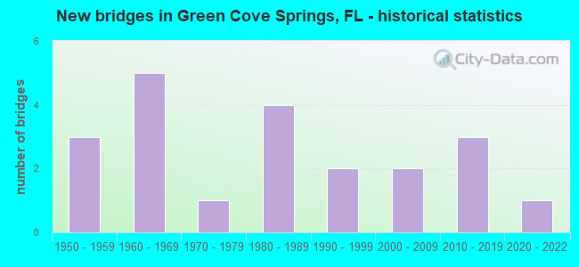
- New bridges - historical statistics
- 31950-1959
- 51960-1969
- 11970-1979
- 41980-1989
- 21990-1999
- 22000-2009
- 32010-2019
- 12020-2022

- Reconstructed bridges - Historical Statistics
- 11970-1979
- 11980-1989


- Bridge Condition - Deck
- 75.0%Good
- 12.5%Satisfactory
- 12.5%Fair

- Bridge Condition - Superstructure
- 37.5%Very good
- 25.0%Good
- 25.0%Satisfactory
- 12.5%Fair

- Bridge Condition - Substructure
- 25.0%Very good
- 37.5%Good
- 37.5%Satisfactory

- Bridge Condition - Channel
- 5.3%Excellent
- 63.2%Good
- 26.3%Satisfactory
- 5.3%Fair

- Bridge Condition - Culverts
- 7.7%Excellent
- 7.7%Very good
- 30.8%Good
- 38.5%Satisfactory
- 15.4%Fair
Find on map >> Show street view
Structure Number: 10087, Location: 1.1MI WEST OF CR-775 (Lat: 26.925139, Lng: -82.357208), Route carried "on" structure: County highway 776, Year Built: 1980, Status: Open, Structure Length: 11.96m (39.24ft), Average Daily Traffic: 11,300 (year 2020), Truck Traffic: 5%, Average Future Daily Traffic: 19,606 (year 2042), Design Load: HS 20, Features Intersected: LEMON BAY
Minimum Vertical Clearance: 30+ m (98+ ft), Kilometerpoint: 0.280, Lanes on structure: 2, Owner: County Highway Agency, Approaching Roadway Width: 10.1m (33.1ft), Material/Design: Concrete continuous, Design/Construction: Slab, Number Of Spans In Main Unit: 12, Length of Maximum Span: 10.4m (34.1ft), Curb or Sidewalk Widths: Left: 1.4m (4.6ft), Right: 0.0m, Curb-To-Curb Width: 10.1m (33.1ft), Out-to-Out Width: 12.6m (41.3ft)
Condition: Deck: Good, Superstructure: Good, Substructure: Good, Channel: Good, Operating Rating: 54.2 metric tons, Method Used To Determine Operating Rating: Load Factor (LF), Inventory Rating: 32.6 metric tons, Method Used To Determine Inventory Rating: Load Factor (LF), Structural Evaluation: Better than present minimum criteria, Deck Geometry: Meets minimum limits, Waterway Adequacy: Equal to present desirable criteria, Approach Roadway Alignment: Equal to present minimum criteria, Designated Inspection Frequency: Every 24 months, Underwater Inspection Frequency: Every 24 months, Inspection Date: June 2020, Underwater Inspection Date: May 2020, Deck Structure Type: Concrete Cast-file-Place
Find on map >> Show street view
Structure Number: 10096, Location: 300FT EAST OF I-75 (Lat: 26.941378, Lng: -82.016381), Route carried "on" structure: US 17, Year Built: 1982, Status: Open, Structure Length: 0.80m (2.62ft), Average Daily Traffic: 16,700 (year 2020), Truck Traffic: 8%, Average Future Daily Traffic: 28,974 (year 2042), Design Load: H 20, Features Intersected: BROAD CREEK
Minimum Vertical Clearance: 30+ m (98+ ft), Kilometerpoint: 3.814, Lanes on structure: 8, Base Highway Network: Yes, Owner: State Highway Agency, Approaching Roadway Width: 37.7m (123.7ft), Skew: 13 degrees, Material/Design: Concrete, Design/Construction: Culvert, Number Of Spans In Main Unit: 2, Length of Maximum Span: 3.2m (10.5ft)
Condition: Channel: Good, Culverts: Satisfactory, Operating Rating: 56.5 metric tons, Method Used To Determine Operating Rating: Load Factor (LF), Inventory Rating: 33.7 metric tons, Method Used To Determine Inventory Rating: Load Factor (LF), Structural Evaluation: Equal to present minimum criteria, Waterway Adequacy: Equal to present desirable criteria, Approach Roadway Alignment: Equal to present desirable criteria, Designated Inspection Frequency: Every 24 months, Underwater Inspection Frequency: Every 24 months, Inspection Date: June 2020, Underwater Inspection Date: May 2020
Find on map >> Show street view
Structure Number: 10101, Location: 4.6MI NORTH OF I-75 (Lat: 26.979347, Lng: -81.959147), Route carried "on" structure: US 17, Year Built: 2005, Status: Open, Structure Length: 13.17m (43.21ft), Average Daily Traffic: 6,250 (year 2020), Truck Traffic: 19%, Average Future Daily Traffic: 10,844 (year 2042), Design Load: HL 93, Features Intersected: SHELL CREEK
Minimum Vertical Clearance: 30+ m (98+ ft), Kilometerpoint: 0.887, Lanes on structure: 2, Base Highway Network: Yes, Owner: State Highway Agency, Approaching Roadway Width: 8.5m (27.9ft), Material/Design: Prestressed concrete, Design/Construction: Stringer/Multi-beam, Number Of Spans In Main Unit: 6, Length of Maximum Span: 21.9m (71.9ft), Curb or Sidewalk Widths: Left: 0.0m, Right: 1.5m (4.9ft), Curb-To-Curb Width: 11.0m (36.1ft), Out-to-Out Width: 13.7m (44.9ft)
Condition: Deck: Good, Superstructure: Very good, Substructure: Good, Channel: Good, Inventory Rating: 60.3 metric tons, Method Used To Determine Inventory Rating: Load Factor (LF), Structural Evaluation: Better than present minimum criteria, Deck Geometry: Equal to present minimum criteria, Waterway Adequacy: Equal to present desirable criteria, Approach Roadway Alignment: Equal to present desirable criteria, Designated Inspection Frequency: Every 24 months, Underwater Inspection Frequency: Every 24 months, Inspection Date: May 2020, Underwater Inspection Date: April 2020, Deck Structure Type: Concrete Cast-file-Place
Find on map >> Show street view
Structure Number: 10103, Location: 5.1 MI NORTH OF I-75 (Lat: 26.982919, Lng: -81.959056), Route carried "on" structure: US 17, Year Built: 2005, Status: Open, Structure Length: 4.54m (14.90ft), Average Daily Traffic: 6,250 (year 2020), Truck Traffic: 19%, Average Future Daily Traffic: 10,844 (year 2042), Design Load: HL 93, Features Intersected: SHELL CRK NORTH SLOUGH
Minimum Vertical Clearance: 30.45m (99.90ft), Kilometerpoint: 1.323, Lanes on structure: 2, Base Highway Network: Yes, Owner: State Highway Agency, Approaching Roadway Width: 9.0m (29.5ft), Material/Design: Prestressed concrete, Design/Construction: Stringer/Multi-beam, Number Of Spans In Main Unit: 2, Length of Maximum Span: 22.7m (74.5ft), Curb or Sidewalk Widths: Left: 0.0m, Right: 1.5m (4.9ft), Curb-To-Curb Width: 11.0m (36.1ft), Out-to-Out Width: 13.7m (44.9ft)
Condition: Deck: Good, Superstructure: Very good, Substructure: Very good, Channel: Good, Inventory Rating: 56.8 metric tons, Method Used To Determine Inventory Rating: Load Factor (LF), Structural Evaluation: Equal to present desirable criteria, Deck Geometry: Equal to present minimum criteria, Waterway Adequacy: Equal to present desirable criteria, Approach Roadway Alignment: Equal to present desirable criteria, Designated Inspection Frequency: Every 24 months, Underwater Inspection Frequency: Every 24 months, Inspection Date: May 2020, Underwater Inspection Date: April 2020, Deck Structure Type: Concrete Cast-file-Place
Find on map >> Show street view
Structure Number: 710006, Location: 1.239 MI. N. OF SR-16 (Lat: 30.006303, Lng: -81.690875), Route carried "on" structure: US 17, Year Built: 1973, Status: Open, Structure Length: 10.06m (33.01ft), Average Daily Traffic: 27,500 (year 2020), Truck Traffic: 7%, Average Future Daily Traffic: 47,712 (year 2042), Design Load: HS 20, Features Intersected: GOVERNORS CREEK
Minimum Vertical Clearance: 30+ m (98+ ft), Kilometerpoint: 2.000, Lanes on structure: 4, Base Highway Network: Yes, Owner: State Highway Agency, Approaching Roadway Width: 17.9m (58.7ft), Navigation Control: Yes ( Vertical Clearance: 2.4m (7.9ft), Horizontal Clearance: 9.5m (31.2ft)), Material/Design: Prestressed concrete, Design/Construction: Slab, Number Of Spans In Main Unit: 10, Length of Maximum Span: 10.1m (33.1ft), Curb or Sidewalk Widths: Left: 3.4m (11.2ft), Right: 1.8m (5.9ft), Curb-To-Curb Width: 17.6m (57.7ft), Out-to-Out Width: 24.3m (79.7ft)
Condition: Deck: Fair, Superstructure: Fair, Substructure: Satisfactory, Channel: Good, Operating Rating: 66.3 metric tons, Method Used To Determine Operating Rating: Load and Resistance Factor (LRFR), Inventory Rating: 51.2 metric tons, Method Used To Determine Inventory Rating: Load and Resistance Factor (LRFR), Structural Evaluation: Somewhat better than minimum adequacy, Deck Geometry: Somewhat better than minimum adequacy, Waterway Adequacy: Equal to present desirable criteria, Approach Roadway Alignment: Equal to present desirable criteria, Designated Inspection Frequency: Every 24 months, Underwater Inspection Frequency: Every 23 months, Inspection Date: March 2021, Underwater Inspection Date: March 2021, Deck Structure Type: Concrete Precast Panels, Wearing Surface/Protective System: Wearing Surface: Bituminous
Find on map >> Show street view
Structure Number: 710016, Location: 0.2 MI WEST OF CR 209 (Lat: 29.936667, Lng: -81.664444), Route carried "on" structure: County highway 226, Year Built: 1963, Status: Open, Structure Length: 0.78m (2.56ft), Average Daily Traffic: 103 (year 2020), Truck Traffic: 10%, Average Future Daily Traffic: 179 (year 2042), Features Intersected: WALKILL CREEK
Minimum Vertical Clearance: 30+ m (98+ ft), Kilometerpoint: 2.588, Lanes on structure: 2, Owner: County Highway Agency, Approaching Roadway Width: 5.6m (18.4ft), Material/Design: Concrete, Design/Construction: Culvert, Number Of Spans In Main Unit: 3, Length of Maximum Span: 2.7m (8.9ft)
Condition: Channel: Satisfactory, Culverts: Satisfactory, Operating Rating: 36.0 metric tons, Method Used To Determine Operating Rating: Load Factor (LF), Inventory Rating: 21.6 metric tons, Method Used To Determine Inventory Rating: Load Factor (LF), Structural Evaluation: Equal to present minimum criteria, Waterway Adequacy: Somewhat better than minimum adequacy, Approach Roadway Alignment: Better than present minimum criteria, Designated Inspection Frequency: Every 24 months, Underwater Inspection Frequency: Every 24 months, Inspection Date: August 2020, Underwater Inspection Date: August 2020
Find on map >> Show street view
Structure Number: 710024, Location: 1.9 MI SOUTH OF US 17 (Lat: 29.935917, Lng: -81.661389), Route carried "on" structure: County highway 209, Year Built: 1950, Status: Open, Structure Length: 0.95m (3.12ft), Average Daily Traffic: 619 (year 2020), Truck Traffic: 10%, Average Future Daily Traffic: 1,074 (year 2042), Features Intersected: WALKILL CREEK
Minimum Vertical Clearance: 30+ m (98+ ft), Kilometerpoint: 5.142, Lanes on structure: 2, Owner: County Highway Agency, Approaching Roadway Width: 6.2m (20.3ft), Material/Design: Steel, Design/Construction: Culvert, Number Of Spans In Main Unit: 2, Length of Maximum Span: 4.7m (15.4ft)
Condition: Channel: Fair, Culverts: Fair, Structural Evaluation: Somewhat better than minimum adequacy, Waterway Adequacy: Somewhat better than minimum adequacy, Approach Roadway Alignment: Equal to present desirable criteria, Designated Inspection Frequency: Every 24 months, Inspection Date: August 2020
Find on map >> Show street view
Structure Number: 710025, Location: 0.46 MI EAST OF US 17 (Lat: 29.926111, Lng: -81.678333), Route carried "on" structure: County highway 226, Year Built: 1963, Status: Open, Structure Length: 1.26m (4.13ft), Average Daily Traffic: 103 (year 2020), Truck Traffic: 10%, Average Future Daily Traffic: 179 (year 2042), Features Intersected: ST. JOHNS TRIBUTARY
Minimum Vertical Clearance: 30+ m (98+ ft), Kilometerpoint: 0.744, Lanes on structure: 2, Owner: County Highway Agency, Approaching Roadway Width: 5.5m (18.0ft), Skew: 2 degrees, Material/Design: Concrete, Design/Construction: Culvert, Number Of Spans In Main Unit: 3, Length of Maximum Span: 4.3m (14.1ft)
Condition: Channel: Satisfactory, Culverts: Satisfactory, Operating Rating: 56.8 metric tons, Method Used To Determine Operating Rating: Load and Resistance Factor (LRFR), Inventory Rating: 36.6 metric tons, Method Used To Determine Inventory Rating: Load and Resistance Factor (LRFR), Structural Evaluation: Equal to present minimum criteria, Waterway Adequacy: Somewhat better than minimum adequacy, Approach Roadway Alignment: Equal to present desirable criteria, Designated Inspection Frequency: Every 24 months, Inspection Date: August 2020
Find on map >> Show street view
Structure Number: 71003, Location: 4.1 MI SOUTH OF US 17 (Lat: 29.907889, Lng: -81.643611), Route carried "on" structure: County highway 209, Year Built: 1950, Status: Open, Structure Length: 0.73m (2.40ft), Average Daily Traffic: 619 (year 2020), Truck Traffic: 10%, Average Future Daily Traffic: 1,074 (year 2042), Features Intersected: BAYARD CREEK
Minimum Vertical Clearance: 30+ m (98+ ft), Kilometerpoint: 1.619, Lanes on structure: 2, Owner: County Highway Agency, Approaching Roadway Width: 6.2m (20.3ft), Material/Design: Steel, Design/Construction: Culvert, Number Of Spans In Main Unit: 2, Length of Maximum Span: 3.0m (9.8ft)
Condition: Channel: Good, Culverts: Fair, Structural Evaluation: Somewhat better than minimum adequacy, Waterway Adequacy: Better than present minimum criteria, Approach Roadway Alignment: Better than present minimum criteria, Designated Inspection Frequency: Every 24 months, Inspection Date: August 2020
Find on map >> Show street view
Structure Number: 710032, Location: 0.4 MI. W. OF CR-15A (Lat: 29.984167, Lng: -81.702778), Route carried "on" structure: State highway 16, Year Built: 1955, Year Reconstructed: 1976, Status: Open, Structure Length: 1.34m (4.40ft), Average Daily Traffic: 14,100 (year 2020), Truck Traffic: 12%, Average Future Daily Traffic: 24,464 (year 2042), Design Load: H 15, Features Intersected: GOVERNORS CREEK
Minimum Vertical Clearance: 30+ m (98+ ft), Kilometerpoint: 35.504, Lanes on structure: 2, Base Highway Network: Yes, Owner: State Highway Agency, Approaching Roadway Width: 12.2m (40.0ft), Material/Design: Concrete, Design/Construction: Culvert, Number Of Spans In Main Unit: 4, Length of Maximum Span: 3.0m (9.8ft)
Condition: Channel: Good, Culverts: Satisfactory, Operating Rating: 75.5 metric tons, Method Used To Determine Operating Rating: Load Factor (LF), Inventory Rating: 45.2 metric tons, Method Used To Determine Inventory Rating: Load Factor (LF), Structural Evaluation: Equal to present minimum criteria, Waterway Adequacy: Equal to present desirable criteria, Approach Roadway Alignment: Equal to present desirable criteria, Designated Inspection Frequency: Every 24 months, Inspection Date: August 2020
Find on map >> Show street view
Structure Number: 710044, Location: 150 FT. N. OF CR-226 E. (Lat: 29.920856, Lng: -81.682858), Route carried "on" structure: US 17, Year Built: 1962, Year Reconstructed: 1994, Status: Open, Structure Length: 0.76m (2.49ft), Average Daily Traffic: 9,700 (year 2020), Truck Traffic: 22%, Average Future Daily Traffic: 16,830 (year 2042), Design Load: H 15, Features Intersected: HALLERD CREEK
Minimum Vertical Clearance: 30+ m (98+ ft), Kilometerpoint: 9.448, Lanes on structure: 5, Base Highway Network: Yes, Owner: State Highway Agency, Approaching Roadway Width: 18.9m (62.0ft), Skew: 13 degrees, Material/Design: Concrete, Design/Construction: Culvert, Number Of Spans In Main Unit: 2, Length of Maximum Span: 3.0m (9.8ft)
Condition: Channel: Satisfactory, Culverts: Good, Operating Rating: 61.6 metric tons, Method Used To Determine Operating Rating: Load Factor (LF), Inventory Rating: 37.1 metric tons, Method Used To Determine Inventory Rating: Load Factor (LF), Structural Evaluation: Better than present minimum criteria, Waterway Adequacy: Equal to present desirable criteria, Approach Roadway Alignment: Equal to present desirable criteria, Designated Inspection Frequency: Every 24 months, Inspection Date: October 2020
Find on map >> Show street view
Structure Number: 710081, Location: 2.6 MI. S. OF SR-16 (Lat: 29.955831, Lng: -81.671864), Route carried "on" structure: US 17, Year Built: 1993, Status: Open, Structure Length: 5.85m (19.19ft), Average Daily Traffic: 5,450 (year 2020), Truck Traffic: 22%, Average Future Daily Traffic: 9,456 (year 2042), Design Load: HS 20+Mod, Features Intersected: CSXRR
Minimum Vertical Clearance: 30+ m (98+ ft), Kilometerpoint: 13.913, Lanes on structure: 2, Base Highway Network: Yes, Owner: State Highway Agency, Approaching Roadway Width: 11.6m (38.1ft), Skew: 4 degrees, Material/Design: Prestressed concrete, Design/Construction: Stringer/Multi-beam, Number Of Spans In Main Unit: 3, Length of Maximum Span: 20.1m (65.9ft), Curb-To-Curb Width: 12.2m (40.0ft), Out-to-Out Width: 13.1m (43.0ft)
Condition: Deck: Good, Superstructure: Good, Substructure: Good, Operating Rating: 65.7 metric tons, Method Used To Determine Operating Rating: Load Factor (LF), Inventory Rating: 39.6 metric tons, Method Used To Determine Inventory Rating: Load Factor (LF), Structural Evaluation: Better than present minimum criteria, Deck Geometry: Better than present minimum criteria, Underclear: Better than present minimum criteria, Approach Roadway Alignment: Equal to present desirable criteria, Designated Inspection Frequency: Every 24 months, Inspection Date: September 2021, Deck Structure Type: Concrete Cast-file-Place
Find on map >> Show street view
Structure Number: 710153, Location: 3.2 MI. S. OF SR-16 W. (Lat: 29.949028, Lng: -81.677972), Route carried "on" structure: US 17, Year Built: 2021, Status: Open, Structure Length: 0.76m (2.49ft), Average Daily Traffic: 10,900 (year 2020), Truck Traffic: 22%, Average Future Daily Traffic: 18,912 (year 2042), Design Load: HL 93, Features Intersected: BUSH CREEK, Facility Carried by Structure: SR-15
Minimum Vertical Clearance: 30+ m (98+ ft), Kilometerpoint: 12.979, Lanes on structure: 4, Base Highway Network: Yes, Owner: State Highway Agency, Approaching Roadway Width: 15.5m (50.9ft), Skew: 10 degrees, Material/Design: Concrete, Design/Construction: Culvert, Number Of Spans In Main Unit: 2, Length of Maximum Span: 3.7m (12.1ft)
Condition: Channel: Excellent, Culverts: Excellent, Operating Rating: 47.4 metric tons, Method Used To Determine Operating Rating: Load and Resistance Factor (LRFR), Inventory Rating: 36.6 metric tons, Method Used To Determine Inventory Rating: Load and Resistance Factor (LRFR), Structural Evaluation: Superior to present desirable criteria, Waterway Adequacy: Better than present minimum criteria, Approach Roadway Alignment: Equal to present desirable criteria, Designated Inspection Frequency: Every 24 months, Inspection Date: January 2022
Find on map >> Show street view
Structure Number: 714041, Location: 0.8 MILE SOUTH OF US 17 (Lat: 29.939333, Lng: -81.670833), Route carried "on" structure: County highway , Year Built: 1988, Status: Open, Structure Length: 1.04m (3.41ft), Average Daily Traffic: 501 (year 2020), Truck Traffic: 10%, Average Future Daily Traffic: 869 (year 2042), Design Load: HS 20, Features Intersected: LITTLE RUTH CREEK, Facility Carried by Structure: J.P. HALL BLVD
Minimum Vertical Clearance: 30+ m (98+ ft), Kilometerpoint: 0.000, Lanes on structure: 2, Owner: County Highway Agency, Approaching Roadway Width: 7.0m (23.0ft), Skew: 2 degrees, Material/Design: Concrete, Design/Construction: Culvert, Number Of Spans In Main Unit: 3, Length of Maximum Span: 3.5m (11.5ft)
Condition: Channel: Satisfactory, Culverts: Satisfactory, Operating Rating: 81.6 metric tons, Method Used To Determine Operating Rating: Load Factor (LF), Inventory Rating: 49.0 metric tons, Method Used To Determine Inventory Rating: Load Factor (LF), Structural Evaluation: Equal to present minimum criteria, Waterway Adequacy: Equal to present desirable criteria, Approach Roadway Alignment: Better than present minimum criteria, Designated Inspection Frequency: Every 24 months, Inspection Date: August 2020
Find on map >> Show street view
Structure Number: 714042, Location: 0.3 MI SOUTH OF US 17 (Lat: 29.946194, Lng: -81.675194), Route carried "on" structure: County highway , Year Built: 1988, Status: Open, Structure Length: 1.17m (3.84ft), Average Daily Traffic: 501 (year 2020), Truck Traffic: 10%, Average Future Daily Traffic: 869 (year 2042), Design Load: HS 20, Features Intersected: REYNOLDS CREEK, Facility Carried by Structure: J.P. HALL BLVD
Minimum Vertical Clearance: 30.18m (99.02ft), Kilometerpoint: 0.000, Lanes on structure: 2, Owner: County Highway Agency, Approaching Roadway Width: 7.0m (23.0ft), Skew: 3 degrees, Material/Design: Concrete, Design/Construction: Culvert, Number Of Spans In Main Unit: 3, Length of Maximum Span: 4.0m (13.1ft)
Condition: Channel: Satisfactory, Culverts: Good, Operating Rating: 81.6 metric tons, Method Used To Determine Operating Rating: Load Factor (LF), Inventory Rating: 49.0 metric tons, Method Used To Determine Inventory Rating: Load Factor (LF), Structural Evaluation: Better than present minimum criteria, Waterway Adequacy: Equal to present desirable criteria, Approach Roadway Alignment: Better than present minimum criteria, Designated Inspection Frequency: Every 24 months, Inspection Date: August 2020
Find on map >> Show street view
Structure Number: 714045, Location: 1.4MI NORTHWEST OF CR 315 (Lat: 30.007500, Lng: -81.748056), Route carried "on" structure: County highway , Year Built: 1991, Status: Open, Structure Length: 0.82m (2.69ft), Average Daily Traffic: 21 (year 2020), Truck Traffic: 10%, Average Future Daily Traffic: 36 (year 2042), Features Intersected: PETERS CREEK, Facility Carried by Structure: ROSEMARY HILL RD
Minimum Vertical Clearance: 30+ m (98+ ft), Kilometerpoint: 0.000, Lanes on structure: 1, Owner: County Highway Agency, Approaching Roadway Width: 5.5m (18.0ft), Design/Construction: Culvert, Number Of Spans In Main Unit: 5, Length of Maximum Span: 1.7m (5.6ft)
Condition: Channel: Good, Culverts: Good, Structural Evaluation: Better than present minimum criteria, Waterway Adequacy: Equal to present desirable criteria, Approach Roadway Alignment: Equal to present minimum criteria, Designated Inspection Frequency: Every 24 months, Inspection Date: August 2020
Find on map >> Show street view
Structure Number: 714056, Location: 1.4 MILES SOUTH OF US 17 (Lat: 30.016944, Lng: -81.696111), Route carried "on" structure: County highway 209, Year Built: 1961, Status: Posted for load, Structure Length: 1.87m (6.14ft), Average Daily Traffic: 9,200 (year 2020), Truck Traffic: 1%, Average Future Daily Traffic: 15,962 (year 2042), Features Intersected: CRK TRIB ST JOHNS RIVER
Minimum Vertical Clearance: 30.45m (99.90ft), Kilometerpoint: 0.460, Lanes on structure: 2, Owner: County Highway Agency, Approaching Roadway Width: 6.1m (20.0ft), Material/Design: Concrete, Design/Construction: Slab, Number Of Spans In Main Unit: 3, Length of Maximum Span: 6.2m (20.3ft), Curb or Sidewalk Widths: Left: 0.2m (0.7ft), Right: 0.2m (0.7ft), Curb-To-Curb Width: 7.3m (24.0ft), Out-to-Out Width: 7.8m (25.6ft)
Condition: Deck: Satisfactory, Superstructure: Satisfactory, Substructure: Satisfactory, Channel: Good, Operating Rating: 12.4 metric tons, Method Used To Determine Operating Rating: Load and Resistance Factor (LRFR), Inventory Rating: 9.8 metric tons, Method Used To Determine Inventory Rating: Load and Resistance Factor (LRFR), Structural Evaluation: High priority of corrective action, Deck Geometry: High priority of replacement, Waterway Adequacy: Equal to present desirable criteria, Approach Roadway Alignment: Equal to present minimum criteria, Bridge Posting: Required (Relationship of Operating Rating to Maximum Legal Load: > 39.9% below), Designated Inspection Frequency: Every 24 months, Other Special Inspection Frequency: Every 12 months, Inspection Date: August 2020, Other Special Inspection Date: August 2021, Deck Structure Type: Concrete Cast-file-Place
Find on map >> Show street view
Structure Number: 714059, Location: 1.065 M S OF DUVAL CO. L (Lat: 30.172181, Lng: -81.830194), Route carried "on" structure: County highway , Year Built: 2010, Status: Open, Structure Length: 1.62m (5.31ft), Average Daily Traffic: 9,001 (year 2020), Truck Traffic: 5%, Average Future Daily Traffic: 15,617 (year 2042), Design Load: HL 93, Features Intersected: PARK ROAD, Facility Carried by Structure: PLANTATION OAKS BL
Minimum Vertical Clearance: 30+ m (98+ ft), Kilometerpoint: 1.975, Lanes on structure: 2, Owner: State Highway Agency, Approaching Roadway Width: 8.2m (26.9ft), Material/Design: Prestressed concrete, Design/Construction: Stringer/Multi-beam, Number Of Spans In Main Unit: 1, Length of Maximum Span: 16.2m (53.1ft), Curb or Sidewalk Widths: Left: 3.1m (10.2ft), Right: 1.9m (6.2ft), Curb-To-Curb Width: 8.2m (26.9ft), Out-to-Out Width: 14.1m (46.3ft)
Condition: Deck: Good, Superstructure: Very good, Substructure: Very good, Operating Rating: 46.0 metric tons, Method Used To Determine Operating Rating: Load and Resistance Factor (LRFR), Inventory Rating: 35.6 metric tons, Method Used To Determine Inventory Rating: Load and Resistance Factor (LRFR), Structural Evaluation: Equal to present desirable criteria, Deck Geometry: High priority of replacement, Approach Roadway Alignment: Equal to present desirable criteria, Designated Inspection Frequency: Every 24 months, Inspection Date: November 2020, Deck Structure Type: Concrete Cast-file-Place
Find on map >> Show street view
Structure Number: 714064, Location: 0.4 MI SOUTH OF US 17 (Lat: 29.956275, Lng: -81.667536), Route carried "on" structure: County highway 209, Year Built: 2015, Status: Open, Structure Length: 0.63m (2.07ft), Average Daily Traffic: 619 (year 2021), Truck Traffic: 10%, Average Future Daily Traffic: 743 (year 2042), Design Load: HL 93, Features Intersected: REYNOLDS CREEK
Minimum Vertical Clearance: 30+ m (98+ ft), Kilometerpoint: 7.491, Lanes on structure: 2, Owner: County Highway Agency, Approaching Roadway Width: 6.2m (20.3ft), Skew: 1 degrees, Material/Design: Concrete, Design/Construction: Culvert, Number Of Spans In Main Unit: 2, Length of Maximum Span: 3.0m (9.8ft)
Condition: Channel: Good, Culverts: Very good, Operating Rating: 45.1 metric tons, Method Used To Determine Operating Rating: Load and Resistance Factor (LRFR), Inventory Rating: 34.7 metric tons, Method Used To Determine Inventory Rating: Load and Resistance Factor (LRFR), Structural Evaluation: Equal to present desirable criteria, Waterway Adequacy: Better than present minimum criteria, Approach Roadway Alignment: Equal to present desirable criteria, Designated Inspection Frequency: Every 12 months, Inspection Date: September 2021
Find on map >> Show street view
Structure Number: 780056, Location: 5 MI.E.OF GREEN COVE SPR. (Lat: 29.983056, Lng: -81.621111), Route carried "on" structure: State highway 16, Year Built: 1961, Status: Open, Structure Length: 203.06m (666.21ft), Average Daily Traffic: 16,500 (year 2020), Truck Traffic: 10%, Average Future Daily Traffic: 28,628 (year 2042), Design Load: H 20, Features Intersected: ST. JOHNS RIVER
Minimum Vertical Clearance: 30+ m (98+ ft), Kilometerpoint: 0.000, Lanes on structure: 2, Base Highway Network: Yes, Owner: State Highway Agency, Approaching Roadway Width: 9.7m (31.8ft), Navigation Control: Yes ( Vertical Clearance: 13.7m (44.9ft), Horizontal Clearance: 27.5m (90.2ft)), Material/Design: Steel, Design/Construction: Stringer/Multi-beam, Number Of Spans In Main Unit: 3, Number Of Approach Spans: 121, Length of Maximum Span: 39.6m (129.9ft), Curb-To-Curb Width: 8.5m (27.9ft), Out-to-Out Width: 10.4m (34.1ft)
Condition: Deck: Good, Superstructure: Satisfactory, Substructure: Satisfactory, Channel: Good, Operating Rating: 42.3 metric tons, Method Used To Determine Operating Rating: Load Factor (LF), Inventory Rating: 25.4 metric tons, Method Used To Determine Inventory Rating: Load Factor (LF), Structural Evaluation: Equal to present minimum criteria, Deck Geometry: Meets minimum limits, Waterway Adequacy: Equal to present desirable criteria, Approach Roadway Alignment: Equal to present desirable criteria, Length Of Structure Improvement: 203.06m (666.21ft), Designated Inspection Frequency: Every 24 months, Underwater Inspection Frequency: Every 23 months, Inspection Date: Febuary 2021, Underwater Inspection Date: Febuary 2021, Bridge Improvement Cost: $500,000, Total Project Cost: $500,000 ( Estimate for 2015), Deck Structure Type: Concrete Cast-file-Place
Find on map >> Show street view
Structure Number: 784084, Location: Kendall Cross/Orange Grov (Lat: 30.020103, Lng: -81.634036), Route carried "on" structure: County highway , Year Built: 2018, Status: Open, Structure Length: 2.27m (7.45ft), Average Daily Traffic: 101 (year 2022), Average Future Daily Traffic: 127 (year 2042), Design Load: HL 93, Features Intersected: Orange Grove Branch, Facility Carried by Structure: Kendall Crossing
Minimum Vertical Clearance: 30+ m (98+ ft), Kilometerpoint: 0.000, Lanes on structure: 2, Owner: County Highway Agency, Approaching Roadway Width: 7.9m (25.9ft), Material/Design: Concrete, Design/Construction: Culvert, Number Of Spans In Main Unit: 2, Length of Maximum Span: 11.0m (36.1ft)
Condition: Channel: Good, Culverts: Good, Operating Rating: 84.5 metric tons, Method Used To Determine Operating Rating: Load and Resistance Factor (LRFR), Inventory Rating: 64.7 metric tons, Method Used To Determine Inventory Rating: Load and Resistance Factor (LRFR), Structural Evaluation: Better than present minimum criteria, Waterway Adequacy: Equal to present desirable criteria, Approach Roadway Alignment: Equal to present desirable criteria, Designated Inspection Frequency: Every 24 months, Inspection Date: January 2022